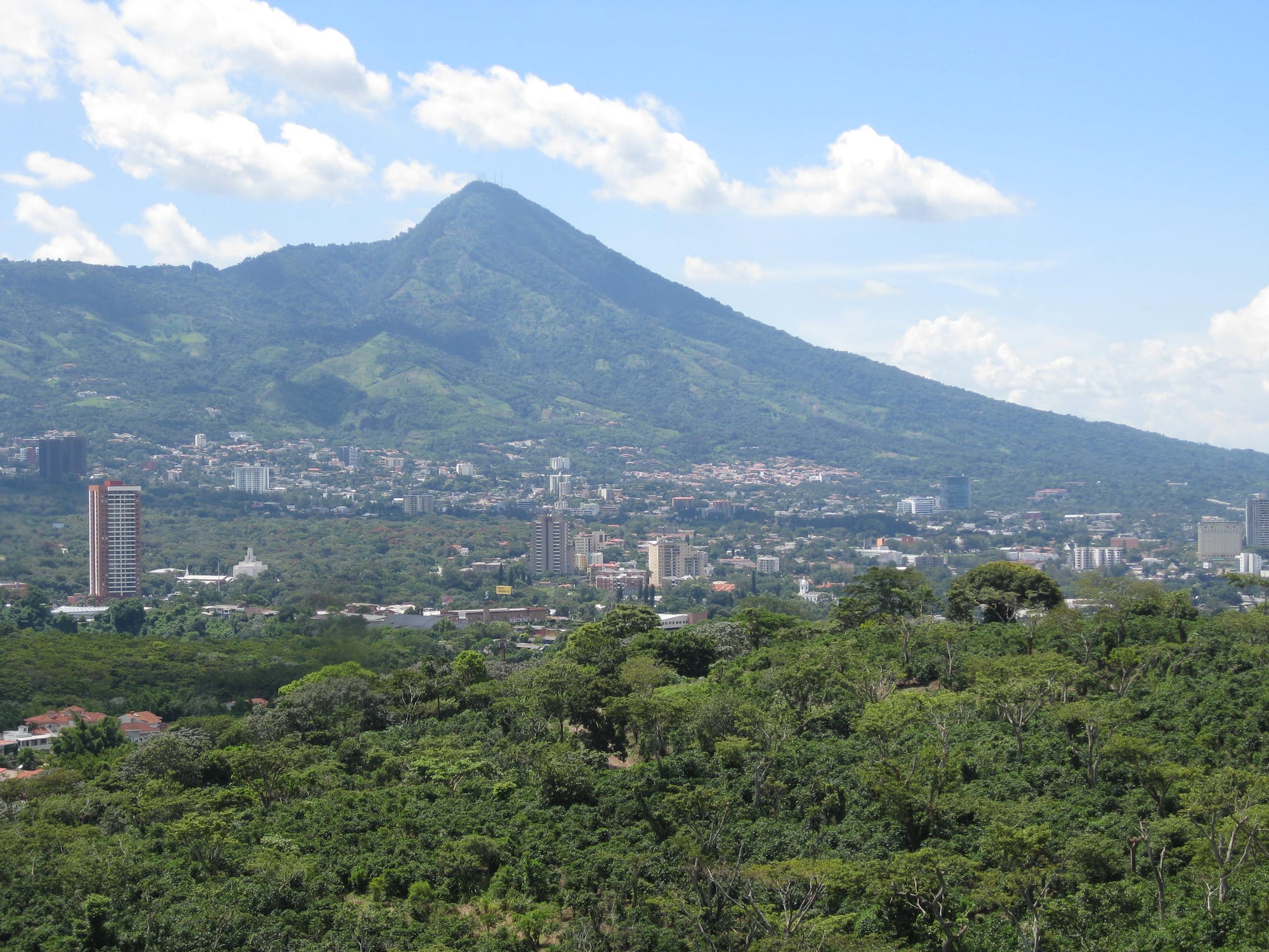
Tower blocks and low-rise districts of San Salvador spread below the green cone of the San Salvador volcano

El Salvador

San Salvador

San Salvador's western districts below the San Salvador volcano. (Sammiethedeadrat / Wikimedia Commons · CC BY-SA 3.0)

El Salvador's capital and largest city, in a valley below the San Salvador volcano and repeatedly shaken by earthquakes. Founded by the Spanish in 1525, it holds the country's government, cathedral and national institutions; today a worn but partly restored historic centre sits beside the towers, malls and restaurants of the western districts.

Neighbourhoods

  • Historic Downtown
    • Historic district
    • First-time visitors
    • Markets

    The city's centre since the 16th century, around the Plaza Libertad and Plaza Gerardo Barrios, with the cathedral, the National Palace and the National Theatre. Few old buildings survived the earthquakes; the area is busy with traders and buses by day and has been the focus of restoration work since 2009.

    Open in Maps
  • Zona Rosa and San Benito
    • Nightlife
    • Best for food
    • Museums

    A compact district in the west of the city known for bars, clubs and restaurants, with the art and anthropology museums close by and the offices of several international bus companies on Boulevard del Hipódromo in San Benito.

    Open in Maps
  • Colonia Escalón
    • Quiet and residential
    • Shopping
    • Best for food

    A wealthy, tree-lined district where office towers and business complexes have risen along Paseo General Escalón among shopping centres, restaurants and residential streets.

    Open in Maps
  • Antiguo Cuscatlán
    • Quiet and residential
    • Shopping

    A separate municipality south-west of the capital and part of its metropolitan area. Its old centre sits in the foothills of the Cordillera del Bálsamo, and it was once the capital of the Pipil before the Spanish conquest.

    Open in Maps

Things to do

Famous landmarks

  • Metropolitan Cathedrallandmark

    The seat of the archdiocese, inaugurated in 1999 with a tiled ceramic façade by Fernando Llort; the tomb of Archbishop Óscar Romero, assassinated in 1980, draws pilgrims to its crypt.

    Open in Maps
  • National Palacelandmark

    The palace built between 1905 and 1911 with materials imported from Europe and paid for by a tax on coffee exports, with four main rooms each in its own colour.

    Open in Maps
  • Plaza Gerardo Barrioslandmark

    The square between the cathedral and the palace, with a 1909 equestrian statue, where Romero's funeral in 1980 ended in disturbances and the end of the civil war was celebrated in 1992.

    Open in Maps
  • National Theatrelandmark

    The theatre on Calle Delgado, begun in 1911 and inaugurated in 1917, described as the oldest in Central America and used for plays, operas, recitals and dance.

    Open in Maps
  • National Librarylandmark

    The national library, opened in November 2023 on the site of the old Francisco Gavidia library and built with the cooperation of China.

    Open in Maps
  • Monument to the Divine Saviour of the Worldlandmark

    A statue of Christ standing on a globe atop a tall pedestal, a symbol of El Salvador, on its own plaza in the west of the city.

    Open in Maps

Museums

  • Museo de Arte de El Salvador (MARTE)museum

    An art museum in the Zona Rosa area, opened in 2003 and one of the two largest museums in the city.

    Open in Maps
  • National Museum of Anthropology (MUNA)museum

    The national anthropology museum, named after David Joaquín Guzmán, who founded it in 1883; its collections include Maya and Pipil artefacts.

    Open in Maps

Volcanoes, lakes and viewpoints

  • El Boquerón National Parkpark

    A park on top of the San Salvador volcano, around a crater five kilometres across and 558 metres deep with a smaller crater inside it, reached by short trails along the rim.

    Open in Maps
  • Lake Ilopangopark

    A crater lake filling a large volcanic caldera immediately east of the capital, ringed by a high, scalloped rim.

    Open in Maps
  • Los Planes de Renderosviewpoint

    A hill district south-east of the city overlooking San Salvador, known for its many pupuserías.

    Open in Maps
  • Puerta del Diabloviewpoint

    The Devil's Gate, a formation of three volcanic crags and a natural viewpoint at the highest point of Los Planes de Renderos.

    Open in Maps

Markets and sport

  • Mercado Nacional de Artesaníasmarket

    A crafts market on Avenida Manuel Enrique Araujo, selling work from around the country.

    Open in Maps
  • Mercado Ex-Cuartelmarket

    A market in the historic centre known for inexpensive souvenirs such as hammocks and local crafts.

    Open in Maps
  • Estadio Cuscatlánattraction

    The national football stadium, opened in 1976, which holds more spectators than any other football ground in Central America and the Caribbean; it was built for the national team's home matches.

    Open in Maps

Short trips from the city

  • Joya de Cerénattraction

    A Maya farming village buried by volcanic ash around AD 600 in the Zapotitán Valley, preserved so well it is called the 'Pompeii of the Americas'; a UNESCO World Heritage Site since 1993.

    Open in Maps
  • Panchimalcoattraction

    A town in the hills south of the capital whose people descend from Nahua families who fled the Spanish takeover of San Salvador in the 16th century.

    Open in Maps
  • Santa Teclaattraction

    The capital of La Libertad department, at the southern foot of the volcano and part of the metropolitan area, formerly called Nueva San Salvador and briefly the national capital after the 1917 eruption.

    Open in Maps

Seasonal events

  • Fiestas of the Divine Saviour of the WorldAugust

    The city's patron-saint festivities around the feast of the Holy Saviour on 5 and 6 August, with Plaza Gerardo Barrios as their focal point.

Eat and drink

Long-standing places and food districts in San Salvador. Hours, ratings and directions come from your maps app, always current.

San Salvador classics

  • Pupuserías of Los Planes de Renderosneighborhood

    The hill district overlooking the city where pupuserías line the road — the classic place for griddled pupusas with curtido and tomato salsa.

    Open in Maps

Food districts

  • Zona Rosaneighborhood

    The city's best-known restaurant and nightlife district, with bars, clubs and restaurants in a small area of the west side.

    Open in Maps
  • Paseo General Escalónneighborhood

    The main avenue of Colonia Escalón, lined with restaurants, cafés and shopping centres.

    Open in Maps

Experience San Salvador

History

The conquistador Gonzalo de Alvarado founded the town of San Salvador on 1 April 1525, during the Spanish conquest of the Pipil lands of Cuzcatlán, and Diego de Holguín became its first mayor. The settlement moved twice, in 1528 and 1545, settling in a valley the Pipil called Zalcuatitán and the Spanish called the Valle de las Hamacas — the Valley of the Hammocks. The old Plaza Mayor stood where Plaza Libertad is now, with the church of the Holy Saviour of the World on its east side.

Earthquakes have shaped the city's whole story. The worst struck in 1854, and in 1917 an eruption of the San Salvador volcano brought earthquakes so damaging that the government moved the capital temporarily to Santa Tecla. The National Palace went up between 1905 and 1911, funded by a tax on coffee exports, and work on the National Theatre began in 1911; it opened in 1917. Few old buildings survived these disasters.

The civil war reached the centre directly: Archbishop Óscar Romero's funeral in 1980 was hit by disturbances in Plaza Gerardo Barrios, in front of the cathedral, and the same square celebrated the end of the war in 1992. The earthquake of October 1986 destroyed many government buildings and left about 200,000 people homeless, and the two earthquakes of 2001 caused more damage. From 2009 the city began a programme to restore the historic centre and move street vendors into markets, and in 2023 a new national library opened there and the city hosted the Central American and Caribbean Games and the Miss Universe pageant.

Culture & Customs

San Salvador is the country's political, cultural, educational and financial centre, home to the government, the Supreme Court, the Catholic archdiocese and the headquarters of the Central American Integration System. Its cultural life is concentrated in a handful of institutions: the National Theatre downtown, the Teatro Presidente where the symphony performs, the art museum MARTE, opened in 2003, and the anthropology museum founded in 1883. The cathedral was completed in 1999 with a festive tiled façade by the Salvadoran artist Fernando Llort.

Religion remains central. The cathedral is the seat of the archdiocese and Archbishop Romero's tomb in its crypt draws pilgrims, while the city is also home to many Protestant churches, among them evangelical, Baptist and Pentecostal congregations. The patron-saint festival around the feast of the Holy Saviour on 5 and 6 August centres on Plaza Gerardo Barrios, and the statue of Christ on a globe in the west of the city is a symbol of El Salvador.

For football there is the Estadio Cuscatlán, built for the national team's home matches and the largest football stadium in Central America and the Caribbean. The city has also become a stage for large events, from the regional games it has hosted since 1935 to the Ibero-American Summit of 2008.

Daily Life

The municipality of San Salvador had about 526,000 inhabitants in 2024, and the metropolitan area, which takes in the capital and its neighbouring municipalities, about 2.4 million. The city is divided into districts with very different lives: the historic centre, crowded with street traders and buses by day, and the wealthy west, where Colonia Escalón and San Benito hold office towers, the World Trade Center and some of the largest malls in Central America.

The capital dominates the national economy as its commercial and financial hub, while neighbouring Soyapango and Ilopango are industrial and Nejapa and Apopa generate power. The US dollar has been the currency since 2001. Traffic congestion is a constant complaint, made worse by the 1980s decision to close downtown streets to cars, and the city's long avenues mean that most people who can afford it travel by car.

Natural hazards are part of daily life. The city sits in a seismically active valley below a volcano, and earthquakes, landslides and tropical storms have repeatedly caused damage. The security crackdown since 2022 has changed life in many neighbourhoods, ending the gangs' extortion of buses and businesses while drawing criticism over due process.

Food

The pupusa is the city's everyday meal: a thick handmade corn or rice tortilla stuffed with cheese, refried beans, chicharrón (fried pork) or loroco flower buds, griddled and eaten with curtido, a tangy cabbage slaw, and a thin tomato salsa. Pupuserías are everywhere, from street corners in the centre to the road through Los Planes de Renderos, the hill district above the city where families go to eat them with a view of the valley.

Beyond pupusas, the city eats the national staples — beans, rice, fried plantain, crema and queso fresco, tamales, yuca frita with chicharrón and panes rellenos, warm stuffed sandwiches — in comedores, simple eateries serving set meals at lunchtime. Zona Rosa and Colonia Escalón hold the city's restaurants, from international cuisine to steakhouses and sushi.

To drink there is horchata made from rice and morro seeds, coffee from the country's highlands, and beer from Industrias La Constancia, the country's largest brewer and bottler of water, which dominates the country's exports of beer and bottled water.

Planning tools

Budget

San Salvador is one of the more expensive places in El Salvador to stay, but still inexpensive by North American standards. The US dollar is the currency, so there is no exchange to manage. Pupusas and comedor meals cost very little; hotels in the western districts, restaurants in Zona Rosa and taxis or ride-hailing between districts are the main costs.

Daily Budget Midrange
USD 80–150 (hotel in the western districts, restaurant meals, museum entry, taxis or ride-hailing)
Daily Budget Shoestring
USD 35–55 (guesthouse, pupusas and comedor meals, city buses)

Carry small notes for buses and taxis; drivers may keep the change if there is no exact fare.

Best Time to Visit

November to April, the dry season, brings sunny days; April and May are the hottest months. From May to October afternoon and evening downpours are usual, and the hills around the city turn green. The patron-saint festivities fill the centre in August.

Suggested Number of Days

Two days cover the historic centre and the western districts. Allowing three or four makes room for the volcano, the lakes and the archaeological sites outside the city, and the capital works as a base for much of the country.

First Visit
2 days
With Surroundings
3–4 days

Transportation

The city is spread out, with long straight avenues and streets that do not follow a grid, so most visitors use taxis or ride-hailing apps. Taxi fares are agreed before getting in. City buses are cheap and cover everything, and four main bus terminals named after the points of the compass serve the rest of the country.

Use registered taxis or apps, agree the taxi fare first and carry exact change.

Airport & Station Connections

El Salvador International Airport (Saint Óscar Arnulfo Romero) is at San Luis Talpa near the Pacific coast, about 42 km from the capital by a four-lane motorway, around 30 minutes by car. Airport taxis and shuttles run into the city, and public bus 138 links the airport with the southern bus terminal. International coaches arrive from Guatemala City and other Central American capitals.

Walkability

Walking is practical within the historic centre and within Zona Rosa and its surroundings, but distances between districts are long and the avenues are built for traffic, so most journeys across the city are made by car. Pavements in the centre are crowded with street traders.

Safety

El Salvador was for years one of the most violent countries in the world, dominated by the MS-13 and Barrio 18 gangs. Since a "state of exception" declared in March 2022 and extended 55 times by September 2026, which suspended some civil liberties and led to more than 90,000 arrests, homicide rates have fallen dramatically, and tourist areas are much safer than a decade ago. In the capital, ordinary crime such as theft and scams is the main concern, above all in crowded areas.

Use registered taxis or apps rather than hailing cars in the street, keep valuables out of sight in the busy centre, and do not photograph police or military. Check current official travel advice before travelling.

Climate

A tropical wet and dry climate, very warm to hot all year, with a dry season from about November to April and a wet season from May to October. The city's height keeps it a little cooler than the coast, and earthquakes are a fact of life.

Summer
hot before the rains — in April and May average highs reach about 32 °C
Winter
the dry months from November to April are sunny, and the coolest months have daily means of about 22 °C

Local Customs

Spanish is spoken everywhere, with the Central American 'vos'. Greet people with a handshake and a 'buenos días' before getting down to business. Dress is neat in the city; shorts and beachwear look out of place in offices and churches. The cathedral and Romero's tomb are places of worship and pilgrimage, and visitors are expected to be quiet and respectful there.

Ask before photographing people, never photograph police, soldiers or prisons, and leave a small tip in sit-down restaurants.

Common Payment Methods

The currency is the US dollar, in use since 2001. Bitcoin was made legal tender in 2021 but lost that status in February 2025, and acceptance is limited. Cards are accepted in malls, hotels and many restaurants; cash in small notes is needed for markets, pupuserías, buses and taxis. ATMs are common in the western districts.