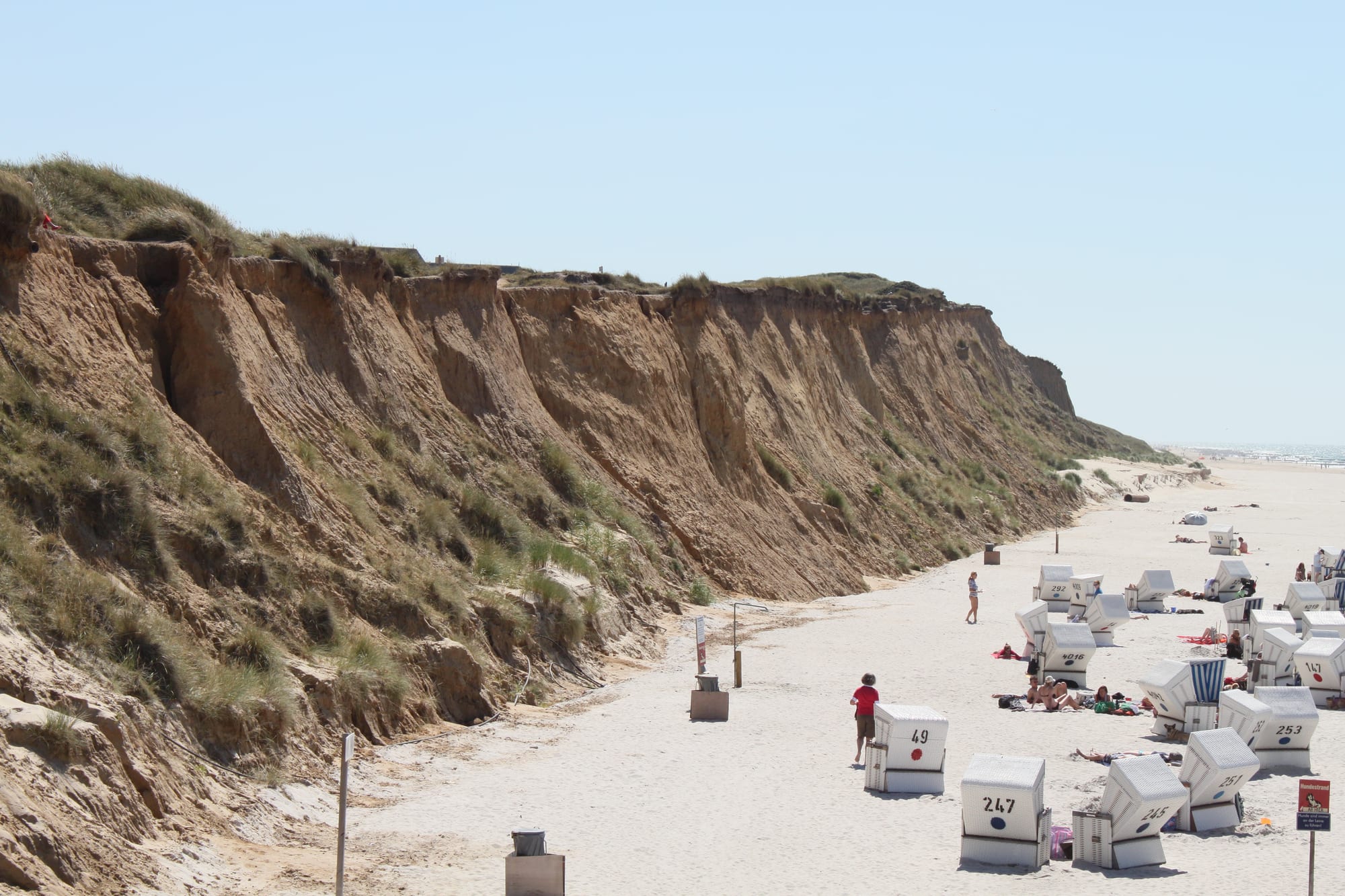
A tall eroded sand cliff with grassy top above a wide white beach dotted with roofed wicker beach chairs

Hamburg & Northern Germany, Germany

Sylt

The beach below the Red Cliff at Kampen on Sylt, lined with Strandkörbe. (Bin im Garten / Wikimedia Commons · CC BY-SA 3.0)

Germany's northernmost island, a long, narrow strip of dunes in the North Sea joined to the mainland since 1927 by a railway causeway. A 40 km sandy beach runs down its western shore and the tidal Wadden Sea lies to the east. Once a home of whalers and sea captains, it is now a resort of the German jet set, fighting constant erosion.

Neighbourhoods

  • Westerland
    • First-time visitors
    • Beaches
    • Close to public transport

    The island's largest town and transport hub, where the causeway trains end and nearly all the island buses meet. A seaside resort since 1855, it has the main shopping streets, a long promenade above the beach and most of the island's shops and restaurants.

    Open in Maps
  • Kampen
    • Nightlife
    • Beaches
    • Upmarket

    A thatched village north of Westerland, famous in the 1950s and 1960s for its celebrities and still the island's most exclusive address. Its beach lies below the Red Cliff, and the bars of the Strönwai are where the island goes out.

    Open in Maps
  • Wenningstedt
    • Families
    • Beaches

    A resort between Westerland and Kampen, known as a family resort for more than a century, with the Neolithic Denghoog grave on its northern edge.

    Open in Maps
  • Keitum
    • Historic district
    • Quiet and residential

    The old island capital on the Wadden Sea side, where wealthy whaling captains settled in the 17th and 18th centuries, with old captains' houses, the Romanesque church of St. Severin and the island museums.

    Open in Maps
  • List and Hörnum
    • Nature
    • Ferries

    The two ends of the island. List, Germany's northernmost municipality, has a harbour with ferries to Denmark and wandering dunes nearby; Hörnum, the youngest village, founded shortly after 1900, sits on the southern headland, losing sand to every winter storm.

    Open in Maps

Things to do

Beaches, cliffs and dunes

  • Red Cliffviewpoint

    A cliff about 30 m high between Wenningstedt and Kampen, where the island's ice-age core shows red above the beach.

    Open in Maps
  • Uwe Duneviewpoint

    The island's highest point, at 52.5 m, near Kampen.

    Open in Maps
  • Wandering dunes of Listtrail

    Shifting sand dunes near List in the island's north, part of the protected dune landscape and crossed only on marked paths.

    Open in Maps
  • Schleswig-Holstein Wadden Sea National Parkpark

    The tidal flats off the island's eastern shore, a bird sanctuary since 1935 and largely dry at low tide, with harbour and grey seals on the sandbanks.

    Open in Maps

Villages and landmarks

  • Kampen Lighthouselandmark

    A white conical stone tower with a broad black band, first lit in 1856, on the Red Cliff between Kampen and Wenningstedt.

    Open in Maps
  • Denghooglandmark

    A Neolithic passage grave from around 3000 BC at Wenningstedt, its name from the Söl'ring words for 'thing' and 'hill'.

    Open in Maps
  • St. Severinlandmark

    Keitum's Romanesque Lutheran church, first documented in 1240, standing apart from the village on higher ground.

    Open in Maps
  • Altfriesisches Hausmuseum

    A historic Frisian house in Keitum, one of the Sölring museums; the village also has the Sylt Museum.

    Open in Maps
  • Hindenburgdammlandmark

    The 11 km railway-only causeway opened in 1927, crossed by every train to the island over the Wadden Sea.

    Open in Maps

Seasonal events

  • Biikebrennen21 February

    Bonfire night across North Frisia, a custom with pagan roots, when great bonfires are lit at their traditional places on the island.

Eat and drink

Long-standing places and food districts in Sylt. Hours, ratings and directions come from your maps app, always current.

Food and nights out

  • Friedrichstraße, Westerlandneighborhood

    Westerland's main shopping street, with restaurants and pubs leading down towards the beach.

    Open in Maps
  • Strönwai, Kampenneighborhood

    Kampen's short street of bars and clubs, the focus of the island's nightlife.

    Open in Maps

Experience Sylt

History

Sylt was once part of the Jutland mainland, and people lived here by 3000 BC, when the Denghoog passage grave was built. The island in its present shape is only about 400 years old: storm floods tore away land again and again, and on 1 November 1436 a surge destroyed the village of Eidum, whose survivors founded Westerland further inland. In 1386 the island was divided between the Duke of Schleswig and the King of Denmark, and from 1435 all of it except List belonged to the Duchy of Schleswig; List stayed with the Danish crown.

In the 17th and 18th centuries whaling, fishing and oyster breeding made the islanders prosperous, and Keitum became the island's capital, where wealthy captains built their houses. Dunes drifting east threatened villages and fields, especially at Rantum, until marram grass was planted in the 18th century. Tourism began in the 19th century: Westerland became a seaside resort in 1855, received town rights fifty years later and replaced Keitum as the capital.

Sylt was a military outpost in the First World War. Visitors had come by boat from Højer, but when Højer became Danish in 1920, a rail causeway was built, and the Hindenburgdamm opened in 1927. In the 1950s and 1960s Kampen drew celebrities, and the island became a resort of the German jet set. In 2009 Westerland, Rantum and Sylt-Ost merged into a single municipality. The fight against erosion goes on: since 1972 tens of millions of cubic metres of sand have been pumped onto the beaches.

Culture & Customs

The old language of the island is Söl'ring, a dialect of insular North Frisian with elements of Danish, Dutch and English, while Listland in the north was traditionally Danish-speaking; village names still appear in Frisian and Danish forms. The Altfriesisches Haus and the Sylt Museum in Keitum keep the memory of the captains' island, with its thatched houses and seafaring families.

The great island custom is the Biikebrennen on 21 February, when bonfires are lit across North Frisia; its roots lie in pagan times, and its meaning has changed over the centuries. Beach culture has its own traditions: the Strandkorb, the roofed wicker beach chair, is rented by the day on the beaches, and Germany's first official nude-bathing beach opened on Sylt in 1920. The best-known groyne on the island, Buhne 16, gave its name to the local naturist beach; the groyne itself has since been removed.

Since the 1950s Sylt has also been a byword in Germany for wealth and glamour, centred on Kampen, and it is constantly in the media, both for its society life and for its exposed position in the North Sea and the land it loses to storm tides.

Daily Life

Sylt had 17,713 inhabitants in 2014 — about 17,700 — nearly half of them in Westerland. The population is far outnumbered by visitors in summer, and the island's economy is built almost entirely around them: shops, restaurants, services and trades are tailored to the needs of guests and of the people who let rooms and houses to them. Many wealthy Germans keep holiday homes here.

Coastal protection is a permanent part of island life. Dredgers pump sand and water onto the beaches, where bulldozers spread it, so that storms remove the artificial sand rather than the shore itself; the work costs around 10 million euros a year, paid by the federal and state governments and the EU. The dunes are nature reserves, the Wadden Sea to the east is a national park, and research stations, among them the Alfred Wegener Institute in List, study the sea and its wildlife.

Life follows the seasons: crowded beaches and late evenings in Kampen in summer, then quiet villages, storm warnings and the bonfires of February in winter. Most journeys to the mainland are made by train across the causeway.

Food

Almost every restaurant on Sylt serves seafood, and the fish burger is something of a takeaway speciality. Nordseekrabben, the small brown shrimps of the North Sea, belong to the traditional cooking of Schleswig-Holstein's west coast.

Oysters have a long history here. Oyster breeding helped make the islanders prosperous in the 17th and 18th centuries, but the native European oyster that once lived in great numbers off Sylt died out around 1950 from overfishing. In the mid-1980s Pacific oysters were introduced and farmed between List and Kampen, and they have since spread well beyond the original beds.

At the other end of the scale, four of the island's restaurants held Michelin stars in 2025. Warming drinks suit the wind: the north's hot specialities include the Pharisäer, sweetened coffee with brown rum under a cap of whipped cream, and Tote Tante ('dead aunt'). In Westerland restaurants line Friedrichstraße, while Kampen's Strönwai is where the island goes for a drink.

Planning tools

Budget

Sylt is the most expensive island in Germany: rooms, beach chairs and restaurant meals cost far more than on the mainland coast, and many houses belong to wealthy Germans as holiday homes. July and August are the dearest months. The bus network and bicycles keep transport costs down, and the beach, the dunes and the cliff walks are free.

Daily Budget Midrange
USD 220–400 (guesthouse or holiday flat, restaurant dinners, a Strandkorb, bike hire)
Daily Budget Shoestring
USD 90–140 (youth hostel or campsite, fish takeaways and supermarket food, island bus pass)

Book accommodation months ahead for July and August.

Best Time to Visit

June to September for swimming weather, long days and open beach bars; June is quieter than the school holidays of July and August, when the island is booked solid. Spring and autumn bring bracing walks, migrating birds and lower prices. Winter is stormy and empty, with the Biikebrennen bonfires on 21 February.

Suggested Number of Days

Two or three days give a feel for the island's villages and beaches. Most holidaymakers stay a week, and a longer stay allows for the quieter ends of the island, cycling and walks on the Wadden Sea side.

First Visit
2–3 days
With Surroundings
5–7 days

Transportation

Buses are the easiest way around and serve the whole island; all routes but one meet at Westerland station, and bicycles can be taken on board. The island is flat, bike paths run its whole length, and bikes can be hired in many places. A car is optional — and has to be brought over by train or ferry.

Stay on the marked paths through the dunes, which are nature reserves; wild paths speed up erosion.

Airport & Station Connections

Trains from Hamburg and the rest of Germany cross the 11 km Hindenburgdamm causeway to Westerland. Cars travel on the shuttle trains between Niebüll and Westerland, or on the car ferry between Havneby on the Danish island of Rømø and List. Sylt Airport, at Westerland, has mostly seasonal flights from major German cities.

Walkability

Westerland, Kampen and Keitum are pleasant on foot, and the beach makes a continuous walking route along the west coast. Distances between the villages are long — the island stretches for many kilometres from List to Hörnum — so most people combine walking with buses or bicycles.

Safety

Germany is a safe country with low levels of violent crime. On Sylt the danger is the sea: concrete groynes hidden at high tide are a hazard to bathers, and storm floods strike the coast.

Swim only at lifeguarded beaches, watch for submerged groynes, and never cross the mudflats without a guide or a tide table. Check current official travel advice before travelling.

Climate

Marine and windy, influenced by the Gulf Stream, with an annual mean temperature of about 8.5°C. The island gets more sunshine than the mainland — on average more than four hours a day across the year.

Summer
cool and bright — summer months average about 17°C, cooler than the mainland despite the longer sunshine
Winter
mild for the north — winter months average about 2°C, with storms

Local Customs

German manners apply: people shake hands with eye contact, and Herr or Frau with the surname is used until first names are offered. When paying in a restaurant, tell the server the total including any tip rather than leaving money on the table. Nude bathing is an old tradition here — Germany's first official naturist beach opened on Sylt in 1920.

Renting a Strandkorb, the roofed wicker beach chair, is the classic way to spend a beach day; ask before photographing anyone, and keep noise down on Sundays.

Common Payment Methods

The currency is the euro. Cards are widely accepted in shops, hotels and restaurants, but some kiosks, bakeries and beach stalls prefer cash. ATMs are found in Westerland and the larger villages.