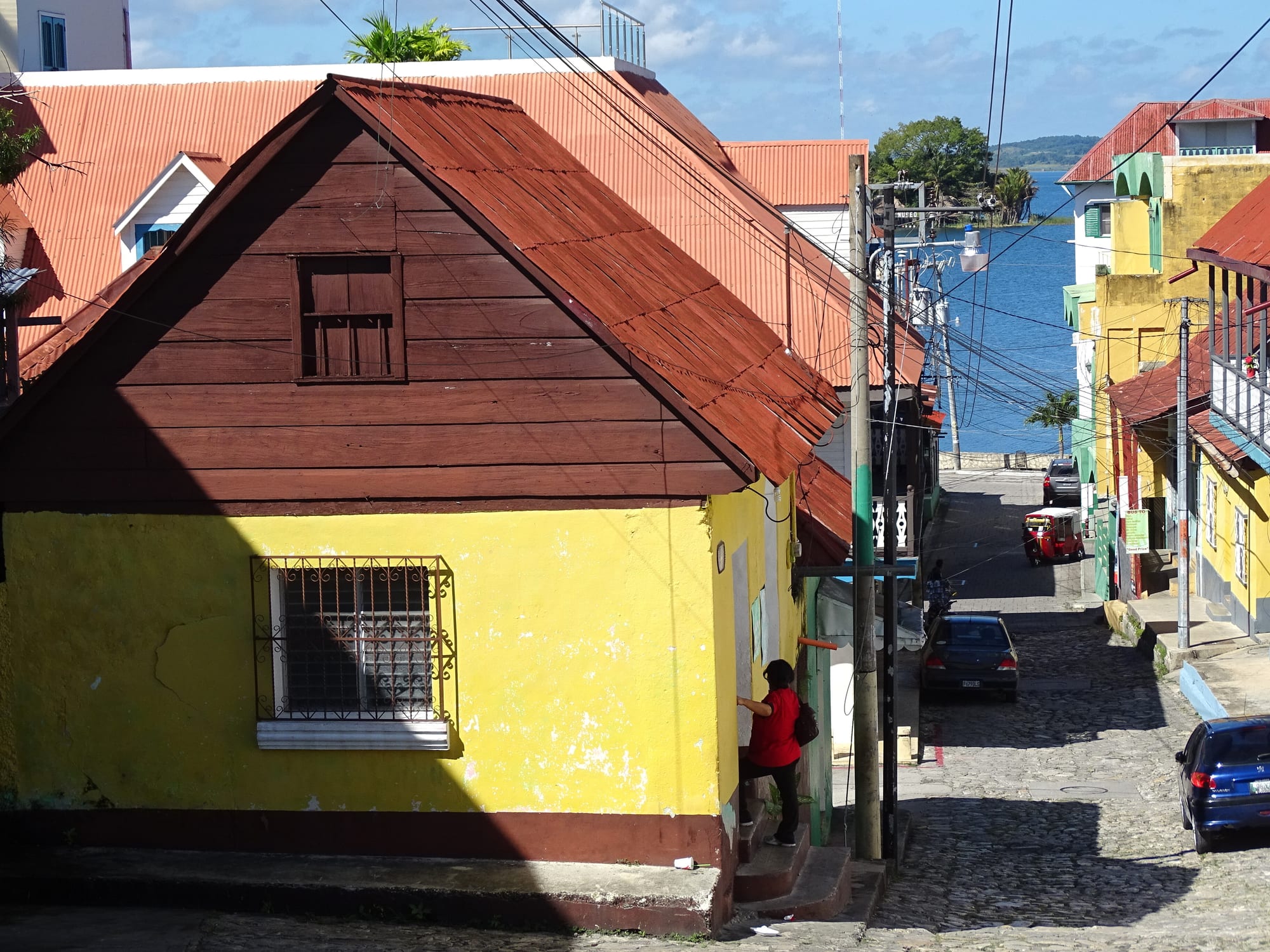
A cobbled street of yellow houses with red tin roofs sloping down to the blue water of the lake

Tikal, the Verapaces & the Caribbean, Guatemala

Flores

A cobbled street on the island of Flores running down to Lake Petén Itzá. (Adam Jones from Kelowna, BC, Canada / Wikimedia Commons · CC BY-SA 2.0)

The capital of Petén, Guatemala's northernmost department — an island town on Lake Petén Itzá joined to the mainland by a short causeway. It stands on the site of Nojpetén, the Itza Maya capital that held out against Spain until 1697, and today its cobbled streets of colourful houses are the usual base for visiting Tikal and the other Maya cities of the Petén forest.

Neighbourhoods

  • Isla de Flores
    • First-time visitors
    • Historic district
    • Lake views

    The old town on the island itself, small enough to walk round in about a quarter of an hour. Red-roofed houses and narrow cobbled streets climb to the central plaza and church at the top, and the lakeside streets are lined with hotels and restaurants looking out over the water.

    Open in Maps
  • Santa Elena
    • Local life
    • Markets
    • Close to the airport

    The mainland town at the far end of the causeway, with the airport, the bus terminals, banks and the sprawling old market. It is busier and less polished than the island, with traffic and street food, and it is where most of the area's everyday business is done.

    Open in Maps
  • San Miguel and the north shore
    • Quiet and rural
    • Lake views

    The small village on the peninsula directly across the water from the island, reached by short boat rides from a pier at the island's northern end. The overgrown ruins of Tayasal lie on the same peninsula, and villages such as San José are reached along the north shore.

    Open in Maps

Things to do

On the island

  • Central plaza and its Maya sculptureslandmark

    The square on the island's highest point, around a central kiosk, with Maya sculptures brought from the ruins of Ixlu at the eastern end of the lake.

    Open in Maps
  • Cathedral of Floreslandmark

    The church on the hilltop plaza, Nuestra Señora de los Remedios y San Pablo Itzá, the cathedral of the Apostolic Vicariate of El Petén.

    Open in Maps
  • Castillo de Arismendilandmark

    Colonial barracks built immediately after the conquest of the Itza in 1697, on the north side of the plaza, now a tourist information centre with a handicraft shop.

    Open in Maps

Around the lake

  • Lake Petén Itzápark

    Guatemala's third-largest lake, about 32 km long, with no surface outflow; boats from the island cross to the villages of the north shore, and there are piers on the island's west side set aside for swimming.

    Open in Maps
  • Tayasal ruinslandmark

    An overgrown Maya site on the San Miguel peninsula just across the water, reached by boat, where a wooden tower on top of the first pyramid gives views across the lake to the island.

    Open in Maps
  • Petencito Zoopark

    A small zoo a short boat ride from the island, with animals of the region, among them monkeys and jaguars, and some rescued by a local wildlife charity.

    Open in Maps
  • Aktun Kanattraction

    The 'cave of the serpent' on the edge of Santa Elena, with formations of stalactites and stalagmites likened to animals and people.

    Open in Maps
  • San Joséattraction

    A small town on the north shore of the lake, reached by boat or road, home to the last speakers of the Itza Maya language; the Classic Maya ruin of Motul de San José lies a few kilometres away.

    Open in Maps

Short trips from the town

  • Tikallandmark

    One of the largest cities of the ancient Maya, capital of one of their most powerful kingdoms, its temple-pyramids rising above the rainforest of Tikal National Park, a UNESCO World Heritage Site since 1979.

    Open in Maps
  • Yaxhalandmark

    A large Maya city on a ridge between Lake Yaxha and Lake Sacnab, once the largest city of the eastern Petén lakes region and at its most powerful in the Early Classic period.

    Open in Maps
  • El Remateattraction

    A village on the eastern tip of the lake, on the road to Tikal, known for small workshops selling handmade wood carvings and for boat trips on the lake.

    Open in Maps
  • Ixlulandmark

    A small Maya site on the isthmus between Lake Petén Itzá and Lake Salpetén, about 23 km east of Flores, once an important lake port.

    Open in Maps

Eat and drink

Long-standing places and food districts in Flores. Hours, ratings and directions come from your maps app, always current.

Flores classics

  • Lakeside restaurants on the islandneighborhood

    Restaurants along the island's waterfront serving lake fish, grilled meats and tortillas alongside international food, many with terraces facing the sunset over the lake.

    Open in Maps
  • Food stands in the island's central parkneighborhood

    Local food stands set up in the plaza at the top of the island and in the little park halfway along the causeway, the cheapest way to eat on the island.

    Open in Maps

Food districts and markets

  • Mercado Viejo, Santa Elenamarket

    Santa Elena's sprawling indoor and outdoor old market, around the old bus terminal, with the area's cheapest street food.

    Open in Maps
  • Grilled chicken stalls by the Santa Elena bus stationneighborhood

    After dark, street sellers near the bus station grill chicken with spring onions and serve it with tortillas.

    Open in Maps

Experience Flores

History

Flores stands on the site of Nojpetén, "great island" in the Itza language, which the Spanish called Tayasal. The earliest archaeological traces on the island date from around 900–600 BC, and the settlement grew substantially around AD 250–400. Later the Itza Maya, who had come from the Yucatán, made the island their capital, a planned ceremonial centre with more than twenty temples, plazas and defences laid out across the lake.

Hernán Cortés stopped at the island on his way to Honduras but moved on without attempting a conquest, and the Itza kingdom remained independent until more than 200 years after Columbus first reached the Americas. In 1697 the Spanish attacked by boat and destroyed the city, making it the capital of the last Maya kingdom to fall to the Spanish; many Itza fled. The colonial town of Flores rose from the ruins, and barracks were built on the plaza immediately after the conquest. Because the island has been lived on since before the conquest, it is counted among the oldest continuously inhabited settlements in the Americas.

For most of the following centuries Flores was a remote outpost of a sparsely populated department; the first photographs of the town were taken in 1897 by the engineer Claudio Urrutia of the Guatemala–Mexico border commission. It became the capital of Petén. From the 1960s the government offered land in Petén to settlers, and the airport and Tikal, a UNESCO World Heritage Site since 1979, made the town the gateway to the Maya cities of the north.

Culture & Customs

Flores is the heart of a conurbation that people usually call by its name alone, taking in Santa Elena and San Benito across the causeway. The island's identity is bound up with Nojpetén and the Itza: the name of the lake itself echoes theirs, and the plaza at the top of the island displays Maya sculptures brought from the ruins of Ixlu. Itza Maya, once the language of the island, is now close to extinction, and the village of San José on the north shore is home to its last speakers. Spanish is the common tongue, and since the 1960s, when the government began offering land in Petén to settlers, the department has been shaped by newcomers from other parts of Guatemala.

The church on the hilltop is the cathedral of the Apostolic Vicariate of El Petén, and Catholic and evangelical churches anchor community life, as across the country. The lake is part of daily culture: people swim from the piers on the island's west side, boatmen ferry passengers to the north-shore villages, and evenings are spent on the waterfront watching the sun go down.

Crafts reflect the forest. Carved woodwork, sold along the road between Ixlu and El Remate, is the typical souvenir of Petén, and shops on the island sell textiles and copies of Maya jade masks found in royal tombs. Spanish schools on the island draw students who stay with local families.

Daily Life

Flores shares an urban area with Santa Elena and San Benito on the mainland shore. As the capital of Petén, Flores is the department's administrative centre, and the conurbation concentrates its commerce, services and tourism; the municipality also stretches far north across thinly populated forest to the Mexican border.

Tourism, above all visits to the Maya sites, is the main source of income. On the island, many houses have become hotels, hostels, restaurants and travel agencies selling shuttles to Tikal, Spanish classes and treks to El Mirador. Santa Elena is where most local people shop and work, around the old market, the bus terminals, the banks and a shopping mall at the end of the causeway.

The day starts early. Tikal shuttles leave before dawn to beat the heat, which builds towards the middle of the day, and life on the island moves to the waterfront in the late afternoon. Tuk-tuks buzz between the island and the mainland, and boats take people across the lake to San Miguel and the north-shore villages.

Food

Flores eats much as the rest of Guatemala does, with tortillas at almost every meal, black beans, and tamales for holidays such as Christmas. Lake fish is the local speciality, served in the restaurants along the island's waterfront alongside grilled meats and tortillas. The Petén forests have long supplied chicle, the natural gum gathered from wild trees, and wild honey from the Tikal forest is sold in the town.

The cheapest food is on the mainland. Around Santa Elena's old market, street stalls sell simple meals, and after dark sellers near the bus station grill chicken with spring onions and serve it with tortillas. On the island itself, food stands set up in the central plaza and in the little park halfway along the causeway, and taquerías cluster at the island's entrance.

Licuados, fruit smoothies made with water or milk, are the everyday drink, and Guatemalan coffee is served in the island's cafés. A locally produced habanero chilli sauce is sold in Flores.

Planning tools

Budget

Flores is inexpensive by international standards, though restaurants on the island cost more than elsewhere in Guatemala, and the cheapest food is in Santa Elena. The main extra costs are Tikal — the entrance fee, guides and shuttles — and private boats on the lake, whose prices are not fixed.

Daily Budget Midrange
USD 65–130 (lakeside hotel, restaurant meals, a guided Tikal visit, private boats)
Daily Budget Shoestring
USD 25–45 (hostel bed on the island, market and street food, shared shuttles and tuk-tuks)

Agree the price with boatmen before setting off, and bring cash: the island's cash machines charge high fees.

Best Time to Visit

The short dry season from February to April is the best time for Tikal and the other ruins, though the heat builds to its peak just before the rains begin. The long wet season, from May to January, brings heavier rain, greener forest and fewer visitors.

Suggested Number of Days

Two or three days cover the island and a visit to the great ruins. Allow longer to reach the other Maya sites of the lakes and forest, which lie some distance away; a multi-day jungle trek to El Mirador adds the best part of a week.

First Visit
2–3 days
With Surroundings
4–6 days

Transportation

The island is walked in minutes, and the causeway to Santa Elena and San Benito takes about ten minutes on foot. Tuk-tuks, vans and buses cover the mainland towns. Boats leave from the island's piers for San Miguel, the zoo and lake tours, and vans and buses run from the Santa Elena market to the villages of the north shore. Shuttles and buses go to Tikal and the other ruins.

Tuk-tuk fares rise at night; agree the fare before getting in.

Airport & Station Connections

Mundo Maya International Airport, the country's second-busiest, is in Santa Elena, about 2 km from the causeway, with flights from Guatemala City. Overnight and daytime buses make the 8–10-hour road trip from the capital to the bus terminal in southern Santa Elena, and shuttles and buses come from Cobán, Lanquín and from Belize by way of the border at Melchor de Mencos.

Walkability

The island is one of the easiest places in Guatemala to explore on foot: a walk round its edge takes about fifteen minutes, though the cobbled streets climb steeply to the plaza. The causeway has pavements to Santa Elena, whose streets are busier and less pleasant to walk.

Safety

Guatemala has significant crime, including gang activity and armed robbery, concentrated in parts of Guatemala City and on some highways and rural routes. The island of Flores itself is generally considered very safe, and the tourist circuit around it is calm. Santa Elena calls for a little more care, with armed guards outside banks and pharmacies, though attacks on individuals are reported to be uncommon. The lake becomes too deep to stand in almost at once off the swimming piers.

Swim only from the designated piers and only if a confident swimmer, use registered shuttles for Tikal, and visit remote Petén sites only with licensed guides. Check current official travel advice before travelling.

Climate

A tropical monsoon climate, hot all year. A long wet season runs from May to January and a short dry season from February to April, though some rain falls even then.

Summer
Daytime highs are typically 30–33°C for most of the year, and often pass 35°C just before the wet season begins.
Winter
In the cooler months around the turn of the year highs fall to about 27–30°C, with rain still frequent.

Local Customs

Spanish is the everyday language; Itza Maya, once spoken here, is now close to extinction. Many people working in tourism also speak English. Bargaining is normal with boatmen and for textiles and crafts, and the road between Ixlu and El Remate is known for carved woodwork, the typical craft of Petén.

Greet people before asking for anything, dress modestly in the cathedral, and ask before photographing people.

Common Payment Methods

The currency is the quetzal (GTQ). Cash in quetzales is needed for boats, tuk-tuks, markets and street food. The cash machines on the island charge high fees, so many visitors bring enough cash with them.