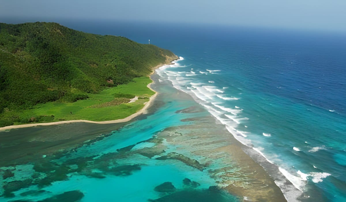
Aerial view of a green, forested headland on Guanaja with a thin beach, turquoise lagoon and waves breaking on the reef

The Bay Islands & the Caribbean East, Honduras

Guanaja

The reef, beach and forested hills along Guanaja's coast. (Denise Clark / Wikimedia Commons · CC BY-SA 2.0)

One of Honduras's three main Bay Islands, about 70 km off the mainland and 12 km from Roatán — a hilly, pine-covered island ringed by reef, where most people live on a small cay crossed by waterways. Columbus landed here in 1502; Hurricane Mitch destroyed most of its buildings in 1998, and it remains the quietest of the islands.

Neighbourhoods

  • Bonacca (The Cay)
    • Island life
    • Historic settlement
    • Close to boats

    A small, densely built cay just off the main island's south shore that holds most of Guanaja's people. Houses stand close together with waterways running between them, which is why it has been called the Venice of Honduras. Boats leave from here for the rest of the island.

    Open in Maps
  • Mangrove Bight
    • Quiet
    • Local life

    One of the two main settlements on the main island, founded by the Moore family, who had come to the Bay Islands from Belize, and one end of the island's single short road.

    Open in Maps
  • Savannah Bight and East End
    • Quiet
    • Local life

    Savannah Bight, at the other end of the road, was founded by families from Olancho and later joined by Cayman Islanders, who also settled the smaller village of East End beyond it.

    Open in Maps

Things to do

Reef and coast

  • The reefattraction

    Clear, warm water around the whole island holds part of the Mesoamerican Barrier Reef, visited by divers and snorkellers from the island's few small resorts.

    Open in Maps
  • Soldado Beachbeach

    The beach on the north side of the island where Christopher Columbus landed in 1502 on his fourth voyage.

    Open in Maps
  • The Canalattraction

    A channel cut through the island that lets boats pass from the south side to the north without sailing all the way around.

    Open in Maps

Hills and waterfalls

  • The island's summitviewpoint

    A hike to the top of the island, which rises to over 350 metres — the highest point in the Bay Islands — gives views of the whole island, its coastline and the surrounding reef.

    Open in Maps
  • North-side waterfall trailtrail

    A nature walk to a waterfall on the north side; Guanaja has more than ten waterfalls.

    Open in Maps

Getting around

  • Guanaja Airporttransit hub

    The island's airstrip, with flights to La Ceiba and Roatán.

    Open in Maps

Short trips from the island

  • Roatánattraction

    The largest Bay Island, 12 km away across the water, with dive villages, long beaches and the Roatán Marine Park.

    Open in Maps

Eat and drink

Long-standing places and food districts in Guanaja. Hours, ratings and directions come from your maps app, always current.

Guanaja classics

  • Seafood on the Cayneighborhood

    Small restaurants on Bonacca cay, where most islanders live, serve the island's catch.

    Open in Maps
  • Mangrove Bight and Savannah Bightneighborhood

    The main island's villages have a few simple places to eat, mostly serving fish and island home cooking.

    Open in Maps

Experience Guanaja

History

Guanaja was home to the Pech, called the Paya by the Spanish, when Christopher Columbus landed at Soldado Beach on its north side on 30 July 1502, on his fourth voyage. There he met a large trading canoe carrying goods from the mainland, and it was on this voyage that he first came across cacao. He named the island Isla de los Pinos, the Isle of Pines, although its people called it Guanaca. Spanish slave raids between 1516 and 1526 were followed by the removal of the remaining native people, and in the 16th and 17th centuries buccaneers used the island and its sheltered waters.

English settlers turned Guanaca into Bonacca, a name older islanders still use. Settler families arrived in the 19th century: the first moved onto two small cays about half a kilometre off the south shore to escape the flies that plagued them on calm nights, and by the 1880s a thriving community had grown up there. Families from Olancho founded Savannah Bight, Cayman Islanders settled East End, and others from Belize built Mangrove Bight. The islands became a British colony in 1852 and passed to Honduras in 1861.

In late October 1998 Hurricane Mitch passed over Guanaja, and two days of winds above 200 km/h destroyed most of its buildings and nearly all of its trees, including almost the entire mangrove forest. The islanders rebuilt, and the forests have slowly been recovering. In October 2021 a fire swept through about 200 structures, without loss of life, and the same year the whole island and its cays were declared a protected Ramsar site.

Culture & Customs

Guanaja's native islanders belong to the Caracol people of the Bay Islands, English-speaking families with roots in the English-speaking Caribbean, established in the islands since the early 19th century. The name is the Spanish word for conch or shell, a nod to their seafaring life. English is the first language of all native islanders, whatever their background, and their form of it keeps many old standard English words; Spanish comes second, though it is spreading as people move in from the mainland.

The island keeps its own calendar of celebrations. Honduran Independence Day on 15 September, Halloween and Christmas are all occasions, and islanders keep the custom of Old Junk, or Junkanoo: groups of people in masks and costumes of old rags run through the streets of the Cay, a custom they consider great fun and one that has gone on for years.

Island identity runs deep. When Honduras took over the Bay Islands it made Guanaja the official name, but the residents kept using Bonacca for as long as they could, and the island's people still see their culture as distinct from the mainland's.

Daily Life

At the 2013 census Guanaja municipality had 5,445 people, most of them on Bonacca, the small cay off the south shore, where houses, shops and walkways crowd together over the water. The other main settlements are Mangrove Bight and Savannah Bight on the main island, with smaller villages such as Pelican Reef, East End and North East Bight. At the census most residents identified as mestizo, with Afro-Honduran, white and Miskito minorities.

Fishing and shrimping are the main sources of income, and tourism is limited to a handful of small resorts that cater to divers, snorkellers and adventure travellers, together with small hotels, restaurants and boat services. The island has piped water, schools, supermarkets, cable television and internet, but its electricity, supplied by a private company, costs several times as much as on the mainland.

Life moves by boat. There is only one road, open since 2006 between Mangrove Bight and Savannah Bight, and there were only about 40 cars on the island by the end of 2011. Boats remain the everyday way to reach school, work and the shops.

Food

Guanaja eats from the sea. Fishing and shrimping are the island's main source of income, shrimping companies are among its employers, and the catch is the base of island cooking.

Island cooking is Caribbean, with coconut running through it: in the coastal areas and the Bay Islands, seafood and some meats are prepared in many ways, including with coconut milk. Sopa de caracol, conch cooked in coconut milk and its own broth with spices, yuca, cilantro and green bananas, is one of the most representative dishes of Honduran cuisine, and rice and beans is a popular side dish along the Caribbean coast.

Mainland food has crossed the water too. Baleadas, flour tortillas filled with refried beans, crumbled hard cheese and cream, are believed to have originated on the north coast. Plato típico, one of Honduras's national dishes, is meat served with refried beans, plantains, chorizo, cheese, chismol salsa and tortillas. Tajadas, fried green bananas, often come with refried beans, and horchata and agua de nance are common drinks with meals.

Planning tools

Budget

Guanaja has no cheap backpacker scene: tourism is limited to a handful of small resorts for divers and adventure travellers. Electricity is far dearer than on the mainland, and getting around depends on boats, which add to the cost of every outing.

Daily Budget Midrange
USD 120–250 (small dive resort or guesthouse, meals, boat transfers and diving)
Daily Budget Shoestring
USD 50–80 (simple guesthouse on the Cay, local food, shared boats)

Ask about boat transfers when booking a room; many places to stay are reached only by water.

Best Time to Visit

February to August usually brings the calmest seas and clearest water around the Bay Islands. The hurricane season runs from June to November, and northern cold fronts bring rain and wind from about October to January. Diving is possible all year.

Suggested Number of Days

Three or four days give time for the Cay, a hike and several dives. A week suits divers and those who want to slow down, and allows for weather that can keep boats in harbour.

First Visit
3–4 days
With Surroundings
1 week

Transportation

Boats are the main way to get around. There is only one road, a short stretch between Mangrove Bight and Savannah Bight, with a few dozen cars and some small motorcycles for rent. Boats link the Cay with the villages and the rest of the island, and the Canal lets boats cut through from the south side to the north.

Agree the price of a boat ride before setting off.

Airport & Station Connections

Guanaja Airport has flights from La Ceiba on the mainland and daily flights from Roatán, as well as charters. Ferries have linked the island with Roatán and, at times, with Trujillo and La Ceiba on some days of the week; schedules change, so they need checking locally. The island is about 70 km off the north coast of Honduras.

Walkability

The Cay is small enough to cross on foot. The villages on the main island can also be walked, but they are separated by hills and water, so moving between them usually means a boat. The trails to the summit and the waterfalls are steep, hot walks.

Safety

Honduras has had one of the highest homicide rates in the world, driven by gangs (MS-13 and Barrio 18) and drug trafficking, and San Pedro Sula and parts of Tegucigalpa remain dangerous. The Bay Islands are the safest part of the country, and Guanaja, the least developed of them, is quiet and small. The practical risks are the sea, the sun and the weather: boat and diving standards vary, and storms can cut the island off.

Choose licensed dive operators, wear a life jacket on small boats, keep an eye on hurricane forecasts from June to November, and avoid isolated beaches after dark. Check current official travel advice before travelling.

Climate

Very warm to hot and humid all year, with rainfall that ranges from moderate to very heavy depending on the trade winds and Caribbean storms. Across the Bay Islands region, temperatures stay at about 27–31°C year-round, and hurricanes are a risk from June to November.

Summer
hot and humid across the region, about 28–33°C, with sea breezes and the hurricane season from June
Winter
warm across the region, about 24–30°C, with rain and wind from northern cold fronts from October to January

Local Customs

English is the first language of native islanders, who are part of the English-speaking Caracol people of the Bay Islands; Spanish is spoken second and is spreading as mainland Hondurans move to the island. Older residents still call the island Bonacca. Holidays matter: Honduran Independence Day, Halloween and Christmas are all marked, and the masked Old Junk, or Junkanoo, runners are part of island tradition.

Greet people in the street, ask before photographing homes and people on the Cay, and dress modestly away from the beaches and boats.

Common Payment Methods

The currency is the Honduran lempira, and US dollars are widely accepted on the Bay Islands. Resorts and dive operators take cards, but the Cay's shops, restaurants and boat drivers mostly work in cash, so it is wise to arrive with enough of it.