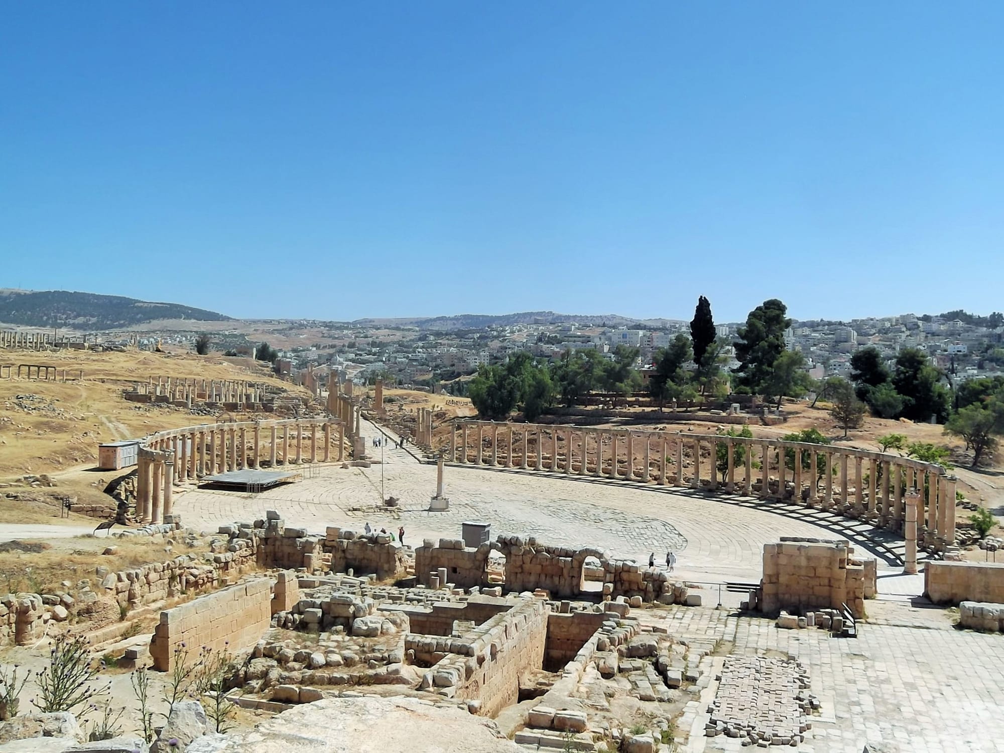
The oval colonnaded plaza of Roman Jerash with a paved street of columns running uphill and the modern town on the slope beyond

Amman, the Dead Sea & the North, Jordan

Jerash

The oval plaza and colonnaded street of ancient Gerasa, with modern Jerash on the hillside behind. (لا روسا / Wikimedia Commons · CC BY-SA 3.0)

A hill town in northern Jordan, about 50 kilometres from Amman, built beside the ruins of Roman Gerasa. The ancient city, buried by earthquake and abandonment and uncovered from the 1920s, keeps colonnaded streets, temples, two theatres and an oval plaza. The modern town, settled by Circassians from the 1880s, spreads across the valley opposite.

Neighbourhoods

  • The archaeological site
    • First-time visitors
    • Historic district
    • Walks

    The walled ruins of Gerasa on the western side of the valley, entered through Hadrian's Arch beside the hippodrome. Almost everything visitors come for lies inside, and covering it takes several hours on uneven stone.

    Open in Maps
  • Town centre
    • Local life
    • Best for food
    • Markets

    The busy streets east of the ruins, where the main road carries traffic between Amman and Irbid past vegetable stalls, bakeries, grills and small shops. Little of it is old, but it is where the town actually eats and shops.

    Open in Maps
  • The Amman road approach
    • Close to transport
    • Hotels

    The southern entrance to the town, where the site car park, ticket office, visitor centre and craft shops sit near the minibus stop. Most of the town's accommodation and coach traffic is concentrated here.

    Open in Maps
  • Souf and the hills
    • Quiet and residential
    • Views

    The olive-covered slopes north-west of the town, with the town of Souf, home to more than 14,000 people, on the heights above. Green and cool by Jordanian standards, and popular with families for picnics in spring.

    Open in Maps

Things to do

The Roman city

  • Arch of Hadrianlandmark

    A triple triumphal gateway at the southern entrance to the site, raised to mark the emperor Hadrian's visit in 129–130 AD.

    Open in Maps
  • Oval Plazalandmark

    The broad oval forum ringed by Ionic columns, paved in limestone slabs laid in curves, where the colonnaded main street begins.

    Open in Maps
  • Temple of Artemislandmark

    The city's temple to its patron goddess, reached by monumental stairways, with eleven Corinthian columns over 13 metres tall still standing.

    Open in Maps
  • South Theatrelandmark

    The larger of the site's two theatres, steeply tiered, with a marked point in front of the stage from which ordinary speech carries to the top rows; it is used during the summer festival.

    Open in Maps
  • Hippodromelandmark

    The elongated arena near the southern gate, built for chariot racing and other public games.

    Open in Maps
  • Jerash Archaeological Museummuseum

    A small museum on Camp Hill above the Oval Plaza, with a chronological display of finds from prehistoric to Islamic times, including sculpture and mosaics.

    Open in Maps

Short trips from the town

  • Ajloun Castlelandmark

    A 12th-century Muslim fortress on a hilltop west of Jerash, built to watch the Jordan Valley and the iron mines around it.

    Open in Maps
  • Ajloun Forest Reservepark

    A protected area of evergreen oak, pistachio and strawberry trees in the hills, with marked walking trails and cabins.

    Open in Maps
  • Dibeen Forest Reservepark

    A reserve of Aleppo pine and oak just south of Jerash, one of the last of Jordan's Mediterranean pine forests.

    Open in Maps
  • Umm Qaislandmark

    The hilltop ruins of Gadara in the far north, with basalt streets and a view over the Sea of Galilee and the Yarmouk valley.

    Open in Maps
  • Pellalandmark

    Another Decapolis city, set on a mound above the Jordan Valley west of Jerash, with layers of settlement from the Bronze Age onwards.

    Open in Maps

Seasonal events

  • Jerash Festival of Culture and Artssummer

    Jordan's largest arts festival, first held in 1981, filling the Roman theatres and the colonnaded street with music, poetry and dance for about three weeks.

  • Olive harvestOctober and November

    The hills around the town are picked and pressed, and fresh oil, olives and soap appear in the local shops.

  • Spring wildflowersMarch and April

    The slopes around the ruins and the Ajloun hills turn green and are covered in poppies, anemones and black iris, drawing families for picnics.

Eat and drink

Long-standing places and food districts in Jerash. Hours, ratings and directions come from your maps app, always current.

Around the ruins

  • Restaurants at the site entranceneighborhood

    Buffet restaurants and cafés beside the visitor centre serve mezze, grilled meat and tea to coach groups and independent visitors.

    Open in Maps
  • Town centre grills and bakeriesneighborhood

    Small shawarma counters, rotisserie chicken shops, falafel stands and bakeries line the main road through the modern town.

    Open in Maps

Local specialities

  • Olive oil and olivesmarket

    Jerash lies in one of Jordan's main olive-growing districts, and shops sell local oil, table olives and olive-oil soap, especially after the autumn pressing.

    Open in Maps
  • Circassian cookingrestaurant

    Descendants of the Circassian settlers keep their own dishes, chicken with garlic sauces among them, which appear at family meals and occasional local restaurants.

    Open in Maps

Experience Jerash

History

People have lived on this small river, the Chrysorrhoas, since prehistory, but the city takes its shape from the Hellenistic foundation of Gerasa, which ancient inscriptions credit to Alexander and his general Perdiccas settling aged Macedonian soldiers there, while other accounts name the Seleucid king Antiochus IV or Ptolemy II. Pompey's campaigns brought it under Rome in 63 BC, and Gerasa became one of the Decapolis, the league of Greek-speaking cities east of the Jordan. Its wealth came from farming the surrounding hills and from the trade that crossed them, and it grew fastest after Rome annexed the Nabataean kingdom in 106 AD and routed caravan traffic through the province of Arabia.

The second and early third centuries were the high point. The temples of Zeus and Artemis, two theatres, the oval plaza, the long colonnaded cardo, baths, gates and the hippodrome all belong to that time; Hadrian's visit in 129–130 AD was marked with the arch that still stands south of the walls. Under Byzantine rule, churches were built with mosaic floors, many of them reusing older stone, and the city remained a bishopric after the Muslim conquest of the 630s.

Decline followed. Earthquakes, above all the great shock of 749, brought down much of the city, and the population dwindled until the site was farmland with ruins standing in it. Crusader and Ayyubid forces passed through, but no town was rebuilt. In 1885 the Ottoman authorities directed Circassian immigrants from the Caucasus to settle at Jerash and shared out farmland among them, founding the modern town on the eastern bank. Excavation has continued since 1925, uncovering one of the most complete Roman provincial cities in the Middle East.

Culture & Customs

Jerash has two identities that sit side by side. One is archaeological: the town has grown up as the gateway to the ruins, and guiding, ticketing, souvenir selling and restoration work employ many families. The other is agricultural and tribal, rooted in the olive groves and wheat fields of the surrounding governorate, where extended families and their elders still carry weight in local affairs.

The Circassian founders left a lasting mark. Their descendants, Muslims who came from the Caucasus in the 19th century, keep their own language among older relatives, their own dishes, and a tradition of dance and horsemanship that appears at weddings and public occasions. Later Palestinian arrivals, including the population of a long-established refugee camp near the town, add another layer, and there is a small Christian community with its own churches.

Since 1981 the Jerash Festival of Culture and Arts has brought Arab and international performers into the Roman theatres each summer, and it remains the event by which many Jordanians know the town. On ordinary days life is slower and conservative: men gather in coffee houses on the main street, weddings fill the road with car horns, and the week turns on Friday prayers and the family lunch that follows. The ruins are a constant presence: schoolchildren are taken round them, and the floodlit columns stand over the town at night.

Daily Life

The town had about 50,700 residents at the 2015 census, and Jerash Governorate — the smallest of Jordan's twelve by area, and the second most densely settled — about 237,000 in all. Much of the working population farms: olives above all, along with wheat, barley, tomatoes and stone fruit on terraced slopes, and the olive harvest in autumn draws whole families into the groves. Government employment, the army and the security services are the other mainstays, as across northern Jordan, and tourism supports hotels, restaurants, guides and craft shops concentrated near the site.

The main road through the town is the spine of daily life, carrying traffic between Amman and Irbid past vegetable stalls, bakeries, phone shops and mechanics. Newer housing climbs the ridges on both sides, and the long-established Palestinian refugee camp on the edge of the town is now an ordinary, if crowded, urban quarter. Unemployment among young people is high, and many commute to Amman or work abroad for periods.

Days begin early, with bread bought fresh and the first shift of the ruins' staff arriving before the coaches. Shops close for a few hours in the afternoon, then reopen into the evening. Water reaches houses on a weekly schedule and is stored in rooftop tanks. In spring and early summer, families drive out to the pine forest at Dibeen or the Ajloun hills to eat outdoors, and in winter the streets empty early in the rain.

Food

The food of Jerash is the food of the northern hills: olive oil in quantity, bread, dairy and vegetables, with meat reserved for guests and occasions. Breakfast is hummus, foul — stewed fava beans with oil, lemon and cumin — and falafel, eaten with raw onion, mint and pickles, or else labneh, strained yoghurt, drizzled with oil and dusted with za'atar, the thyme and sumac mixture that also flavours the flat bread called manaqish baked in the town's ovens.

Mansaf, the national dish of lamb cooked in a sauce of jameed — hard dried fermented yoghurt — and served over rice and shrak bread, appears at weddings, funerals and Friday lunches. Maqluba, the upside-down pot of rice, aubergine and meat, and musakhan, chicken roasted on bread heaped with onions and sumac, come from the Palestinian kitchen and are cooked widely here. Galayet bandora, tomatoes fried hard with onion, chilli and oil, is the everyday standby, and mahshi, vegetables stuffed with rice and minced meat, the Sunday-best version.

Circassian families keep their own dishes, among them chicken served with garlic and soured-milk sauces. The olive oil pressed in the surrounding hills each November is a point of pride, sold in tins at the roadside along with olives, olive-oil soap and jars of wild honey. Sweets mean knafeh, cheese pastry in syrup, brought hot from Amman or made locally, and the drinks are strong tea with mint or sage and small cups of cardamom coffee.

Planning tools

Budget

Jerash is an inexpensive stop. The main cost is the site ticket, which is covered by the Jordan Pass bought before arrival, and transport from Amman. Guesthouses in and around the town and in nearby Ajloun cost far less than hotels in the capital, and food in the town centre is cheap.

Daily Budget Midrange
USD 110–240 (mid-range hotel, restaurant meals, a hire car or driver from Amman, site entry)
Daily Budget Shoestring
USD 35–60 (guesthouse room, falafel and shawarma meals, minibuses from Amman)

The Jordan Pass covers entry here and at most other sites and includes the entry visa, so it usually pays for itself.

Best Time to Visit

March to May and October to November, when the ruins can be walked without heat and the hills are green or freshly harvested. The summer festival brings crowds. Midsummer days are hot and there is almost no shade on the site; winter is cold and wet, with snow in some years, though the ruins are quiet and dramatic under cloud. The war that began in February 2026 has disrupted aviation and tourism across the region.

Suggested Number of Days

Most visitors come from Amman for half a day and return the same afternoon. Staying overnight allows a slower visit and time for the hills and castles to the west. Festival dates and a strong interest in archaeology both push the number up.

First Visit
half a day
With Surroundings
2 days

Transportation

The town is small enough to cross on foot, and the site entrance is a short walk from the main road. Minibuses run to Amman's northern terminal, to Irbid and to Ajloun through the day, leaving when full and thinning out by late afternoon. Taxis wait near the entrance, and many visitors arrive with a hire car or a driver hired for the day.

Check the last minibus back before setting out; services are sparse in the evening and on Fridays.

Airport & Station Connections

Jerash lies about 50 kilometres north of Amman, roughly an hour by road on the highway through the hills, and about 40 kilometres south of Irbid. There is no railway. Most visitors come by hire car, by taxi or driver from the capital, on an organised coach trip, or by minibus from Amman's northern bus station. Aviation across the region has been disrupted by the war that began in February 2026.

Walkability

The archaeological site is walked end to end over Roman paving and slopes, and the stones are uneven and slippery when wet, so firm shoes matter. The modern town is compact but hilly, with narrow pavements along a busy through road. Shade is scarce everywhere.

Safety

Jerash is a quiet town with very low crime, and visitors are commonly approached only by souvenir sellers and guides near the entrance. The practical risks are heat and sun on the open site, uneven ancient paving, and traffic on the main road. Since February 2026 the wider region has been at war.

Carry water and a hat, take care on worn paving, and agree any guide's fee before starting. Check current official travel advice before travelling.

Climate

A Mediterranean climate in the northern hills, wetter and greener than most of Jordan: the governorate's yearly rainfall, between about 400 and 600 millimetres, is among the highest in the country. Rain falls between November and April; the rest of the year is dry.

Summer
hot and dry, usually around 30–34°C by day, with cooler evenings in the hills
Winter
cool and wet, typically 5–13°C, with heavy rain and occasional snow

Local Customs

The town is more conservative than western Amman. Covered shoulders and knees are appropriate, particularly in the town centre and markets, and long trousers are usual for men. Greetings are exchanged before business, hospitality is offered readily, and alcohol is rarely seen outside hotels. During Ramadan most eating places are closed in daylight and visitors avoid eating or drinking in the street.

Ask before photographing residents, and expect to bargain politely with the souvenir sellers near the site entrance.

Common Payment Methods

The currency is the Jordanian dinar. The ticket office, hotels and the larger restaurants take cards, but shops, stalls, minibuses and small eating places are cash only. There are a few ATMs in the town centre; it is easier to draw cash in Amman before coming.