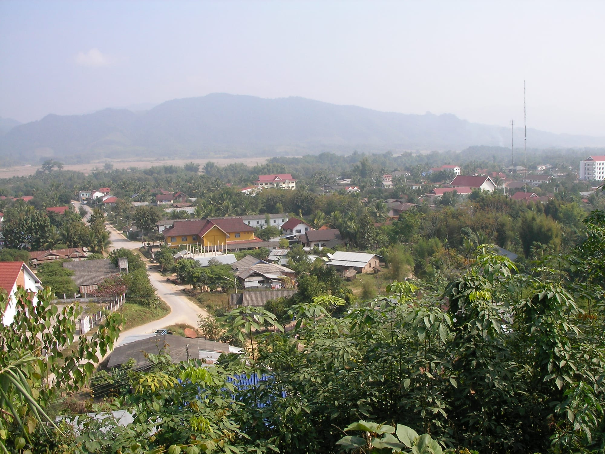
Low houses with red and yellow roofs among palms and trees in a wide valley, with hazy forested ridges behind

Luang Prabang & the North, Laos

Luang Namtha

The northern part of Luang Namtha in its valley, with the surrounding hills beyond. (Brian Dell / Wikimedia Commons · Public domain)

The capital of Luang Namtha province in the far north-west of Laos, a low-rise town of one long main street set in a broad rice valley between forested ridges. Rebuilt on a new site after the war, it lives from farming, cross-border trade with China and Thailand, and from community trekking into the Nam Ha protected area.

Neighbourhoods

  • The main street and the night market
    • First-time visitors
    • Best for food
    • Close to transport

    The new town runs along a single broad road holding the guesthouses, trekking agencies, banks and restaurants. The night market at its centre is where the town eats in the evening, and the district bus stand is a short walk away.

    Open in Maps
  • Around the morning market
    • Local life
    • Markets
    • Cheaper stays

    A block of covered stalls and shopfronts that fills before dawn with traders from the valley villages and from the Chinese border, selling produce, textiles, tools and Chinese goods. The surrounding streets are workaday and inexpensive.

    Open in Maps
  • The old town and the rice valley
    • Quiet and residential
    • Cycling
    • Views

    A few kilometres south, around the airfield and the stupa hill, lie the remains of the older settlement and a spread of villages among paddy fields. Flat lanes between the fields make this the part of the district most people explore by bicycle.

    Open in Maps

Things to do

In and around the town

  • That Luang Namthalandmark

    A gilded stupa on a hill south of the new town, rebuilt after the war, with a view over the valley and its rice fields.

    Open in Maps
  • Luang Namtha Museummuseum

    The provincial museum, with displays on the ethnic groups of the north-west, their dress, textiles, tools and musical instruments, and on the province's history.

    Open in Maps
  • Luang Namtha night marketmarket

    An open hall of food stalls on the main street where the town gathers after dark for grilled meat, noodles, sticky rice and rice wine.

    Open in Maps
  • Ban Nam Dee waterfallattraction

    A modest waterfall a few kilometres north of the town, reached through a Lanten village and bamboo groves, and a common short bicycle ride.

    Open in Maps

Forest and villages

  • Nam Ha National Protected Areapark

    A protected forest of about 2,200 square kilometres west and north of the town, monsoon forest that also holds an important bird area, where guided one- to three-day treks stay in Khmu, Akha and Lanten villages under a long-running community tourism scheme.

    Open in Maps

Short trips from the town

  • Muang Singattraction

    A small town in a valley about 60 kilometres north-west, once a Tai Lue principality on the opium trade route, with a morning market that draws Akha and Tai Dam villagers from the hills.

    Open in Maps
  • Botenattraction

    The crossing into China north-east of the town, opposite Mohan, where a special economic zone is being developed and the Laos–China Railway has its northernmost Lao station; a casino built in 2002 was closed at China's request in 2011 and stands abandoned.

    Open in Maps

Seasonal events

  • Pi Mai Lao (Lao New Year)mid-April

    Water throwing, temple offerings and family gatherings across the province, celebrated alongside the new year customs of the valley's Tai communities.

  • Boun Bang Fai (rocket festival)May

    Bamboo rockets are fired from village monasteries to ask for rain before the rice is planted in the valley.

  • Akha and Hmong new year celebrationsNovember to January

    Held village by village after the harvest, with embroidered and silver-hung costume, swings, courtship games and feasting in the hills around the town.

Eat and drink

Long-standing places and food districts in Luang Namtha. Hours, ratings and directions come from your maps app, always current.

Where the town eats

  • The night market food hallmarket

    Rows of stalls selling grilled chicken and pork, sai oua sausage, papaya salad, sticky rice, noodle soups and fried river fish, eaten at shared tables.

    Open in Maps
  • The morning marketmarket

    Produce from the valley and the hills — bamboo shoots, forest greens, herbs, chillies, river fish, buffalo meat — traded from before dawn, with noodle stalls for breakfast.

    Open in Maps
  • Main street restaurantsrestaurant

    Small kitchens along the main road serve Lao dishes such as laap and jaew with sticky rice, Tai Lue specialities, Chinese stir-fries and travellers' standards.

    Open in Maps

Experience Luang Namtha

History

The Nam Tha valley has long been a corridor between the Mekong, the Sipsong Panna country of southern China and the Tai principalities of the upper Mekong. Tai Lue and Tai Dam settlers farmed the flat land, while Khmu villages held the slopes and Akha, Lanten and Hmong communities arrived later on the higher ridges, many migrating south from Yunnan during the 19th century. Caravan traffic in salt, cotton, tea and opium passed through the valley and through Muang Sing to the north-west.

Under the French protectorate the area was governed lightly from a small administrative post, and its trade continued to face north and west rather than towards Vientiane. The town was fought over in the Battle of Luang Namtha from January to May 1962, when Royal Lao Army troops were driven out by Pathet Lao and North Vietnamese forces and retreated south across the Mekong, and the north-west lay on contested supply routes through the war years; what survives of the older settlement stands near the airfield and the stupa hill several kilometres south of the present centre, which was laid out afterwards along a single wide road.

Two developments have shaped the town since. The Nam Ha National Protected Area was decreed in 1993 and enlarged in 1999, and the Nam Ha Ecotourism Project, run jointly with UNESCO, trained village guides and routed trekking income into the villages themselves; it won the Equator Prize in 2006 and put Luang Namtha on the backpacker map. Then came China: the border crossing at Boten, the highway, rubber and banana plantations and, from 2021, the Laos–China Railway, which has bound the province into Chinese trade and travel far more tightly than into the rest of Laos.

Culture & Customs

Luang Namtha province counts more than twenty ethnic groups, and this is the thing residents mention first about it. Lowland Lao and Tai Lue keep Theravada Buddhist monasteries and festivals in the valley; Khmu villages on the middle slopes follow their own spirit practices; Akha villages on the ridges are known for indigo cloth, elaborate headdresses heavy with silver and coins, and the carved gates and swings that mark the village boundary and calendar; Lanten households, closely related to the Yao, make their own paper and dye cloth a deep blue.

Textiles are the strongest craft. Tai Lue weaving on frame looms, Akha embroidery, Lanten indigo and Hmong batik are all made in villages within a day of the town and sold at the markets and in shops on the main street. Music and ceremony follow each group's own calendar rather than a shared one, and the mixture is what the provincial museum sets out to explain.

Trekking has made cultural etiquette a practical matter here, because most routes stay overnight in villages. Guides explain the rules that matter: not touching spirit gates or carved figures, waiting to be invited into a house, asking before photographing, and treating a homestay as a household rather than a hotel. Lao manners otherwise apply — soft voices, the nop, modest dress and shoes at the door.

Daily Life

Luang Namtha is a small district capital, and the province around it held about 176,000 people at the 2015 census, thinly spread over forested hills. Wet rice in the valley and upland rice, maize and livestock on the slopes are still the base of most household economies, with government work, market trade, transport and tourism in the town itself.

The Chinese border, an hour away, is the strongest force on the local economy. Rubber and banana plantations have replaced forest and swidden fields on land leased to Chinese companies, traders sell Chinese goods in the markets, warehouses and freight yards have grown around the railway, and young people cross for work. The changes have brought cash, roads and electricity, and also disputes over land, falling rubber prices in weak years and concern about forest loss in a province that markets itself on nature.

Days are early and short: markets before dawn, fields and offices through the morning, a quiet afternoon, and the night market at dusk before the town goes still. Health care is a provincial hospital with limited facilities, secondary schooling draws families in from the villages, and seasonal work in Thailand supports many households. Mobile coverage is good in the valley and patchy in the hills.

Food

Cooking here belongs to upland Laos, with Tai Lue and Chinese influences from across the border. Sticky rice is eaten at every meal with jaew, a pounded chilli dip, and laap, minced meat or fish tossed with herbs, lime, chilli and toasted rice powder. Bamboo shoots boiled with dill and yanang leaf, stewed buffalo, and pork grilled over charcoal are standard, and river fish from the Nam Tha is grilled whole or steamed in banana leaf as mok pa.

The forest fills the markets according to season: wild mushrooms, ferns, banana flower, tamarind leaf, river weed and herbs that have no English names, alongside the valley's rice and the cabbages and greens grown on the cooler slopes. Tai Lue households make fermented and pickled vegetables and their own rice spirit, and Akha and Khmu villages serve visitors lao hai, rice beer drunk through reeds from a communal jar.

Breakfast is khao piak sen, soft hand-cut rice noodles in chicken broth, or a bowl of feu with herbs and lime. Chinese noodle shops and stir-fry kitchens on the main street reflect the border trade, and sai oua sausage, coconut sweets and grilled sticky rice cakes are the standards of the night market. Lao coffee with condensed milk, green tea grown in the north and Beerlao complete the table.

Planning tools

Budget

Luang Namtha is cheap. Guesthouse rooms and market food cost very little, and the significant expense is a guided trek into the Nam Ha protected area, priced per group so that costs fall sharply when travellers join together. Bicycle and motorbike hire and the long bus journeys in and out are the other outlays.

Daily Budget Midrange
USD 40–90 (better hotel, restaurant meals, a two-day guided trek or a private driver)
Daily Budget Shoestring
USD 15–30 (guesthouse room, night market meals, bicycle hire, local buses)

Draw kip in the town before heading to Muang Sing or into the hills, where cash machines are scarce and only cash is taken.

Best Time to Visit

November to February is the trekking season: dry trails, clear valley views and cool nights, with mist over the rice fields at dawn. March and April are hot and hazy with smoke from field burning. The rains from May to October leave the valley intensely green but make forest paths muddy and leeches common.

Suggested Number of Days

Most visits to the town itself last about two days. Four suit travellers taking a longer guided trek or continuing to other towns in the north-west. Road journeys in and out are long, which is worth allowing for.

First Visit
2 days
With Surroundings
4 days

Transportation

The new town is walkable and the flat valley is ideal for the bicycles and scooters hired along the main street. Tuk-tuks and shared songthaews run to the old town, the bus station and nearby villages. Buses and minivans link the town with Huay Xai, Oudomxay, Luang Prabang, Muang Sing and the Chinese border at Boten, where the railway can be joined.

Mountain roads are slow and wet-season landslides are common, so allow a full day for any long journey and expect departures early in the morning.

Airport & Station Connections

Louangnamtha Airport, 6 kilometres south of the centre, handles domestic flights. Most travellers arrive by road, from Huay Xai on the Thai border, from Oudomxay, or over the mountains from Luang Prabang, which takes most of a day. The Laos–China Railway runs through the east of the province, and travellers join it at the border town of Boten, about an hour away by minivan.

Walkability

The centre is a flat, straight kilometre or so, and everything a visitor needs — guesthouses, agencies, banks, markets — lies along it. Pavements are patchy and lighting thin after dark. The stupa, the old town and the village lanes are too far to walk comfortably but easy by bicycle on level ground.

Safety

The town is quiet and crime against visitors is rare. The main hazards are road traffic and rented scooters on rough roads, river currents in the wet season, and the forest itself: trails are remote, and treks should be made with licensed guides. Unexploded ordnance remains a risk in the wider north, so paths matter. The province borders areas associated with smuggling and cross-border crime, though this does not usually touch travellers.

Trek with a licensed guide, keep to marked paths, carry insect repellent and treat leech and tick bites promptly, and carry enough cash and any medication. Check current official travel advice before travelling.

Climate

Tropical monsoon weather moderated by an upland valley setting, with a distinct dry season from November to April and heavy rain from May to October. Valley mist is common on winter mornings.

Summer
warm and very wet, generally 27–33°C, with rain most days from June to September
Winter
dry and mild by day at about 24–28°C, falling to 8–12°C at night, with dawn mist over the fields

Local Customs

The province is one of the most ethnically diverse in Laos, with Khmu, Akha, Lanten, Tai Lue, Tai Dam and Hmong communities alongside lowland Lao. Village customs vary: some Akha villages have spirit gates at the entrance that outsiders must not touch, houses should only be entered when invited, and ceremonies are not public events. Temple manners are the Lao ones, with covered shoulders and shoes left at the door.

Follow a guide's instructions in villages, ask before photographing people, and buy handicrafts directly from weavers rather than photographing them at work without asking.

Common Payment Methods

The Lao kip is the currency, and cash is needed for nearly everything. Cash machines on the main street accept foreign cards, with limits and fees, and a few hotels and agencies take cards. Chinese yuan and Thai baht circulate near the borders but give poor value, and mobile payment apps used across the Chinese border are not a substitute for kip.