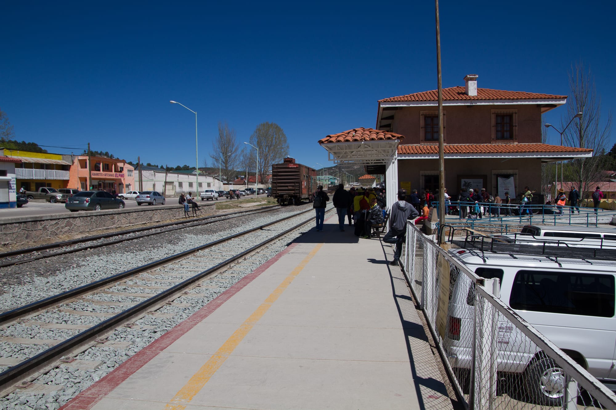
A railway platform beside the tracks, with a two-storey station building with a red tiled roof and travellers waiting under a deep blue sky

Sonora, Chihuahua & the Northwest, Mexico

Creel

The platform and station building of the Chepe railway in Creel. (Foto Eule / Wikimedia Commons · CC BY-SA 4.0)

A small mountain town in the pine forests of the Sierra Tarahumara in Chihuahua, founded in 1907 as a station on the Chihuahua–Pacific railway. Once a logging town, it now lives mainly on tourism as a base for the Copper Canyon, Lake Arareco and the waterfalls of the sierra, and many of its people are Rarámuri.

Neighbourhoods

  • Town centre and the station
    • First-time visitors
    • Close to public transport
    • Best for food

    The railway station faces the central plaza, with the Catholic church and a mission craft shop beside it. Most hotels, restaurants, souvenir shops and tour offices line the main street, Avenida López Mateos, within a few minutes' walk.

    Open in Maps
  • The Arareco lands
    • Nature
    • Walking and cycling
    • Rarámuri communities

    The forested mesa immediately east of town, with the Valley of the Frogs, the Valley of the Monks and Lake Arareco. Dirt roads and paths lead past rock valleys, the San Ignacio mission church and the lake, and can be covered on foot, by bicycle or on horseback.

    Open in Maps

Things to do

Around the town

  • Creel stationtransit hub

    The stop of the Chepe, the passenger railway across the Sierra Madre between Chihuahua and Los Mochis, standing in front of the town's central plaza.

    Open in Maps
  • Main plaza and mission shopattraction

    The central square with the Catholic church, where the Tarahumara mission store sells maps, guidebooks and local crafts, its proceeds supporting Rarámuri schools and clinics.

    Open in Maps

Lakes, valleys and waterfalls

  • Lake Ararecopark

    A U-shaped lake south of Creel, surrounded by unusual rock formations and pine forest.

    Open in Maps
  • Valle de los Monjesviewpoint

    The Valley of the Monks, a valley of rock formations on the mesa east of town, often visited on foot, by bike or on horseback.

    Open in Maps
  • Valle de las Ranasviewpoint

    The Valley of the Frogs, another valley of rock formations on the same mesa east of Creel.

    Open in Maps
  • Misión de San Ignaciolandmark

    The mission church of San Ignacio near Creel, one of the classic stops on the circuit of sights around Creel.

    Open in Maps
  • Cusárare Fallstrail

    A waterfall about 30 metres high in a canyon a few kilometres beyond Lake Arareco, reachable by bicycle or on foot.

    Open in Maps
  • Recohuata hot springstrail

    Hot springs in a canyon below the mesa, reached by following the stream that flows out of Lake Arareco as it gradually cuts the Tarahueca canyon.

    Open in Maps

Short trips from the town

  • Copper Canyonpark

    A system of six canyons covering about 65,000 square kilometres, carved by rivers draining the western Sierra Tarahumara, with walls of a copper-green colour.

    Open in Maps
  • Divisaderoviewpoint

    A key stop on the railway and a lookout over the Urique Canyon, with trailheads for hiking down into the gorge.

    Open in Maps
  • Basaseachic Falls National Parkpark

    A national park around Basaseachic Falls, at 246 metres the second-highest waterfall in Mexico, which runs dry in the spring and autumn dry seasons.

    Open in Maps
  • Batopilasattraction

    An old silver-mining town at the bottom of the Batopilas canyon, prominent from the early 18th to the early 20th century and the second town in Mexico to have electricity.

    Open in Maps

Eat and drink

Long-standing places and food districts in Creel. Hours, ratings and directions come from your maps app, always current.

Creel classics

  • Avenida López Mateosneighborhood

    The main street, where most of the town's restaurants serve regional Mexican food, with food carts selling hot dogs and burgers in the evening.

    Open in Maps
  • Tío Molcasrestaurant

    A long-popular restaurant on the main street, serving regional Mexican dishes, with a bar and a fireplace for the cold mountain nights.

    Open in Maps
  • Market grillsmarket

    Grills set up during the day near the town's small market area.

    Open in Maps

Experience Creel

History

Creel began on 26 May 1907 as Estación Creel, a depot on the new Chihuahua al Pacífico railway, built on a Rarámuri settlement called Seegórachi. It took its name from Enrique Creel, the governor of Chihuahua at the time, whose railway company completed the line from Chihuahua as far as here. The town was planned as an agricultural colony in which a small number of Mexican families would spread their way of life among a Rarámuri majority — 25 Mexican and 75 Rarámuri families were intended — but in its early years only about 30 Rarámuri families settled.

For many years the railway ended at Creel, and the town grew as a logging centre in the pine forests of the sierra. The line was finally carried across the Sierra Madre to the Pacific in 1961, making Creel a stop on one of the most celebrated train journeys in Mexico.

Over the last twenty years or so tourism has replaced timber as the main source of work, as visitors have come for the Copper Canyon, Basaseachic Falls and the lakes and rock valleys around the town. Hotels, restaurants and tour companies have multiplied, and in 2007 Creel was named a Pueblo Mágico, the federal title given to towns with history, traditions and appeal for visitors. A regional airport was opened outside the town in 2023.

Culture & Customs

Creel's identity is bound up with the Rarámuri, the Indigenous people of the Sierra Tarahumara, called Tarahumara by the Spanish. Estimates put their numbers at between 50,000 and 70,000. Many live in scattered settlements, some moving between the cooler uplands in summer and the warmer canyon floors in winter, and many keep their independence by living far from town life. In Creel itself their language is widely used, including at mass.

The Rarámuri are known around the world for long-distance running, which has ceremonial as well as practical meaning. In rarajipari races, men kick a wooden ball along mountain paths in relays, while women race with a stick and hoop; their running in huaraches, simple sandals, became famous through the book Born to Run. Community gatherings, called tesgüinadas after the corn beer drunk at them, mark rain and harvest ceremonies, healing, the feast of Guadalupe, races and Holy Week. Matachín dancers, lavishly dressed in colourful costume, perform with rattles.

Along the railway, Rarámuri families lay out food, crafts and other wares for sale. Tourism is a growing industry but its acceptance is debated in local communities. Holy Week is the busiest time of year in Creel, when visitors from the large cities of central Mexico fill the town.

Daily Life

The 2010 census counted about 5,000 people in Creel, the second-largest town of Bocoyna municipality after San Juanito. At about 2,350 metres it is one of the highest points on the railway, and it serves as a centre of commerce for the surrounding sierra as well as for visitors.

Work now revolves around tourism: hotels and guesthouses, restaurants, souvenir shops, guides, horse and bike hire and transport to the canyons. Logging, the town's original industry, has faded in importance. Outside the town, Rarámuri families farm maize and beans and keep cattle, sheep and goats, and the mission store on the plaza helps to fund schools and clinics for Rarámuri children. The sierra faces pressures from population growth and open-pit mining, which has polluted the air and damaged wildlife.

Life follows the sun and the trains. Days are bright and mostly mild, and nights are cold for much of the year. The main street fills when tour groups arrive, and in the evening food carts set up downtown.

Food

Creel's kitchens serve the food of Chihuahua: dishes in red chile colorado sauce, beef, flour tortillas and the mild melting cheese made by the state's Mennonite farmers, sold as queso menonita or queso Chihuahua. Most restaurants on the main street offer a similar menu of regional Mexican dishes, and in the evening carts sell hot dogs and burgers, while grills work near the small market area by day.

Rarámuri cooking rests on maize. Corn is planted in February and March and harvested in November, and is eaten as pinole, ground toasted corn, as tortillas, atole, tamales and roasted ears, with beans, squash and greens alongside. Batári, known in Spanish as tesgüino, is a fermented drink made from sprouted corn, central to Rarámuri gatherings.

The state spirit is sotol, distilled from plants of the genus Dasylirion and produced only in Chihuahua, Coahuila and Durango. Many visitors eat on the main street, where one popular restaurant keeps a bar with a fireplace for cold nights, a reminder that this is mountain country even when the days are warm.

Planning tools

Budget

Creel itself is inexpensive, with small hotels, guesthouses and simple restaurants. The costs come from getting here and getting around: the railway's first-class carriages, guided tours into the canyons, hired bikes, horses or cars, and lodges on the canyon rim are priced for visitors.

Daily Budget Midrange
USD 80–180 (comfortable hotel or lodge, restaurant meals, guided canyon tours, first-class train)
Daily Budget Shoestring
USD 30–50 (budget hotel, main-street meals, buses and economy-class train)

Prices and crowds rise in Holy Week, when the town fills with visitors from Mexico's big cities; shop around among the many local guides.

Best Time to Visit

October and November bring clear skies after the summer rains and full waterfalls, and March and April are also good. Winter days are bright and comfortable, but nights are cold, with frost most mornings from October to April. Summer is green, with afternoon storms. Basaseachic Falls dries up in the spring and autumn dry seasons.

Suggested Number of Days

Two or three days cover the town and the lakes and valleys around it. Allow four to six for longer trips into the canyons or an overnight stop on the rim; the train and bus timetables often decide the number.

First Visit
2–3 days
With Surroundings
4–6 days

Transportation

The centre is walkable, and the sights of the nearby mesa are reached on foot, by hired mountain bike, on horseback or with a local guide. Tours run to the canyons and waterfalls, and buses go to Divisadero, Batopilas and other towns of the sierra.

Take local advice before going deeper into the sierra, and treat the canyon roads beyond Creel with caution.

Airport & Station Connections

Creel is about 175 km south-west of Chihuahua City, whose international airport is the nearest with regular flights; buses run between the two cities. The town is a stop on the Chepe railway between Chihuahua and Los Mochis on the Pacific coast, but services on parts of the line have changed in recent years, so current timetables need checking. A regional airport opened outside town in 2023.

Walkability

The town is small and easy on foot, with the station, plaza and main street together. The mesa to the east is good walking and cycling country, with Lake Arareco and the rock valleys within reach; at 2,350 metres, the altitude makes climbs harder than they look.

Safety

Safety varies enormously by state and even neighbourhood. The main Copper Canyon stops, Creel among them, receive visitors, but remote parts of the Sierra Tarahumara see serious violence linked to organised crime, and the situation can change quickly.

Stay on the main tourist circuit, use local guides for trips into the canyons, avoid remote roads and night travel, and dress for cold nights. Check current official travel advice before travelling.

Climate

At about 2,350 metres, Creel has a cool subtropical highland climate: mild days and cold nights, with frost on most mornings from October to April. Winter brings some rain, but snow falls on only a few days a year in the town, more often on the surrounding peaks.

Summer
mild, with the region's figures for the sierra at 20–28°C and afternoon storms
Winter
comfortable by day and cold at night, with frost most mornings, occasional snow and lows that can fall as far as −15°C

Local Customs

Many people in and around Creel are Rarámuri, and their language is heard in daily life and at church services. Ask before photographing anyone, and buy crafts directly from the makers. A tip of 10–15 per cent is usual in restaurants. Hats and sunglasses come off in church, and the formal usted is the polite way to address strangers.

Tourism is welcomed by some Rarámuri communities and debated in others; keep to public paths and visit communities with a local guide.

Common Payment Methods

The currency is the Mexican peso. Cards are taken at the larger hotels and some restaurants, but this is a small mountain town: bring enough cash for meals, guides, bike or horse hire and crafts, and for trips to places with no cash machines.