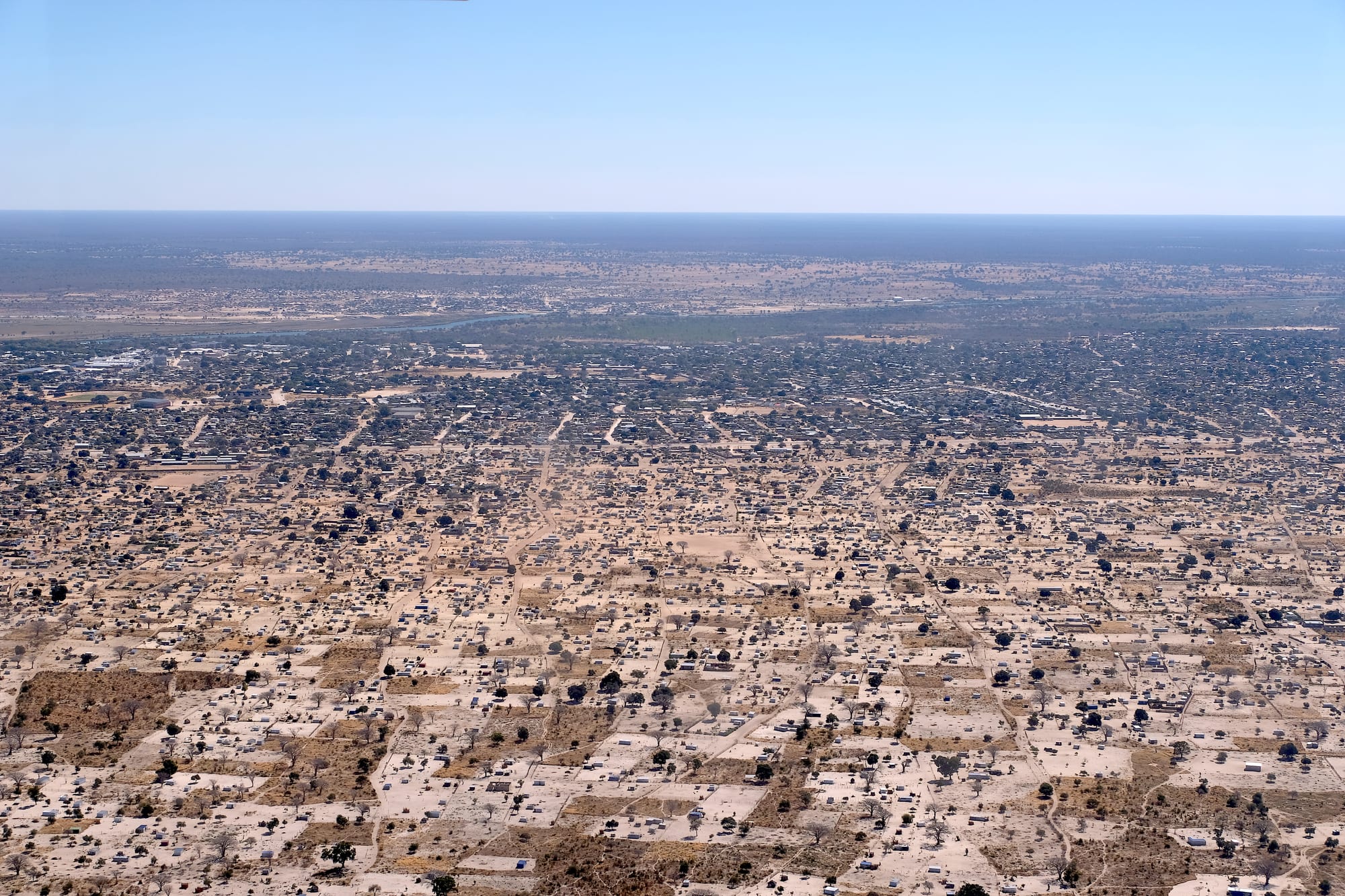
An aerial view of a wide low town of fenced plots and scattered trees reaching towards a river and flat bush beyond

Etosha & the North, Namibia

Rundu

Rundu from the air, its housing plots spreading south from the Okavango river, with Angola on the far bank. (Hp.Baumeler / Wikimedia Commons · CC BY-SA 4.0)

The capital of the Kavango East Region, spread along the south bank of the Okavango river in Namibia's wet north-east, with the Angolan town of Calai visible across the water. It has grown into one of the country's largest towns, a trading centre for a densely settled river district and the main stop on the long road east towards the Zambezi region.

Neighbourhoods

  • The town centre
    • First-time visitors
    • Practicalities
    • Markets

    A cluster of shopping centres, banks, fuel stations, government offices and open-air stalls set back from the river on the main road. It is busy from early morning, and it is where the whole district comes to trade, bank and catch transport.

    Open in Maps
  • The riverfront
    • Views
    • Quiet and residential
    • Birdwatching

    The strip along the Okavango east and west of the centre, where lodges and campsites sit under big trees above the water, looking across to Angola. Fishermen work the channels below, and it is the part of Rundu most visitors actually stay in.

    Open in Maps
  • The southern suburbs
    • Local life
    • Quiet and residential

    The residential areas spreading south and east from the centre, among them Sauyemwa, Ndama and Kaisosi, a mix of built houses, fenced plots and homesteads with mahangu fields at the edges. This is where most of Rundu's people live.

    Open in Maps

Things to do

On the river

  • Okavango Riverattraction

    The broad, permanent river that gives the town its reason to exist, running east towards the Okavango Delta; boat trips from the lodges go out for birds, hippos and the light at the end of the day.

    Open in Maps
  • The riverfront viewpointsviewpoint

    The high bank above the water east of the centre, where the ground drops to reed beds, fishing canoes and the Angolan town of Calai on the far side.

    Open in Maps

Markets and crafts

  • The woodcarvers' stallsmarket

    Open-air stands along the main road selling bowls, drums, masks, animals and furniture carved from local hardwoods, the craft the Kavango regions are known for across Namibia.

    Open in Maps
  • Rundu open marketmarket

    The town's main trading ground, with mahangu meal, dried fish, vegetables, second-hand clothes and grilled meat sold from stalls and from the ground.

    Open in Maps

Short trips from the town

  • Nkurenkuruattraction

    A small riverside town west of Rundu, capital of Kavango West, in a stretch of villages, mahangu fields and mission churches along the Okavango.

    Open in Maps

Eat and drink

Long-standing places and food districts in Rundu. Hours, ratings and directions come from your maps app, always current.

Eating in Rundu

  • Grills and stalls at the open marketmarket

    Beef, goat and chicken grilled over open fires and sold by the piece with pap or fat cakes, alongside dried river fish and sacks of pounded mahangu meal.

    Open in Maps
  • The town centre's cafés and takeawaysneighborhood

    Chicken and chip counters, bakeries and a few sit-down restaurants in and around the shopping centres, serving the standard Namibian mix of grills, burgers, pies and stews.

    Open in Maps
  • The river lodges' kitchensneighborhood

    The places along the bank cook the local bream whole over coals or fried, along with steaks and game, and are the usual spot for a drink over the water.

    Open in Maps

Experience Rundu

History

Five small kingdoms grew up along this stretch of the Okavango, among them the Kwangali, Mbunza, Shambyu, Gciriku and Mbukushu, whose people farmed millet on the floodplain, fished the river and kept cattle back from the water. The river was a route rather than a barrier, and families and cattle moved between both banks long before any border was drawn on a map. The line that separated German South West Africa from Portuguese Angola cut through that world, and left communities divided between two colonial states.

The Germans never ruled this far north directly, and the area lay outside their Police Zone; Catholic and Protestant missions arrived instead, and the South African administration that followed the First World War governed lightly and recruited labour heavily, sending men south to the mines and farms under the contract system. Rundu itself grew from an administrative post on the river, and in 1936 it became the seat of the local governor, replacing Nkurenkuru as the capital of the Kavango district.

Its modern size comes from war. Fighting between South African forces and SWAPO's guerrillas spilled across the border through the 1970s and 1980s, and the Angolan civil war drove refugees and returnees to the Namibian bank, while the military built roads, an airfield and a garrison. After independence in 1990 and the end of the Angolan war in 2002, people stayed and more arrived, and the town has expanded across the sand for kilometres. The Kavango was split into two regions in 2013, and Rundu became the capital of Kavango East.

Culture & Customs

Rundu is a Kavango town, and the traditional authorities of the river's kingdoms still carry weight in matters of land, custom and dispute alongside the elected regional government. Rukwangali is the most widely used language, with Thimbukushu and other Kavango languages, and Portuguese and Angolan music are heard because of the traffic across the water. Extended families organise life, and a great many households divide themselves between a town job and a homestead in a village along the river.

Woodcarving is the craft the region is known for across Namibia. Carvers work hardwood into bowls, drums, masks, animals and furniture, sell along the main road here, and supply the big craft markets in the centre of the country; some families have done it for generations. Basketry, pottery and drumming are strong local traditions too, and Kavango dance groups perform at public events.

Christianity is near-universal, Catholic and Lutheran above all, and church gatherings, weddings and funerals are the big social occasions, often lasting a whole weekend and drawing relatives from far away. Fishing is both work and identity, done from dugout canoes with nets and lines. Manners are formal in a quiet way: greetings, handshakes and enquiries after the family come first, and respect for elders and for chiefs is expected.

Daily Life

About 118,600 people were counted in Rundu at the 2023 census, which makes it one of Namibia's largest towns, and it has grown faster than almost anywhere else in the country. The growth is horizontal: fenced sand plots with a built house or a homestead stretch for kilometres south of the river through Sauyemwa, Ndama and newer areas, many of them without piped water, tarred roads or connections to the grid, while the centre holds the shops, banks and offices.

Work is scarce and mostly informal. Government offices, schools, the hospital and the shopping centres provide the salaried jobs; beyond them people trade, carve, fish, farm mahangu and vegetables on the floodplain, and run stalls and shared taxis. Cross-border trade with Angola adds to the market, and tourism supports the river lodges. Rural poverty in the Kavango regions is deeper than elsewhere in Namibia, and unemployment among the young is the dominant issue.

The day begins before sunrise, when the market fills and the river is busiest, and slows in the afternoon heat. The river sets the rhythm of the year as much as the calendar does: high water after the rains, fields planted with the first storms, fish traps and canoes at low water. Malaria, flooding in wet years and drought in dry ones are the recurring hardships.

Food

The staple is oshifima, a stiff porridge of pounded mahangu — the pearl millet grown on the floodplain — eaten with the fingers with a relish of meat, beans or wild greens. Mahangu is pounded by hand in wooden mortars, and sacks of the meal are one of the market's main trades. Maize meal is eaten the same way when millet is short.

Fish is what makes the food here different from the rest of Namibia. Bream from the Okavango is grilled whole over coals, fried, or dried and smoked for keeping and for trade, and catfish and tigerfish are caught too. River fish with porridge is the everyday meal in the villages, and the lodges serve the same bream cooked whole for visitors. Goat and beef are grilled over open fires at the market and sold by the piece, as kapana is elsewhere in the country.

Drinks and seasonal foods come from the trees and the rains. Oshikundu, a lightly fermented millet drink, is made at home and sold in containers at the market; marula fruit makes a fermented drink brewed for celebrations, and its kernels are pressed for oil. Wild fruits, mopane caterpillars and the big mushrooms that grow on termite mounds after the rains are gathered and sold at the roadside. Lager and Portuguese-influenced tastes from Angola round out the town's drinking.

Planning tools

Budget

Rundu is one of the cheaper places to stay in Namibia. Guesthouses in town and campsites along the river cost little, market food costs even less, and the riverside lodges are moderate by national standards, with boat trips charged separately. Fuel for the long distances on either side of the town is usually the largest single expense.

Daily Budget Midrange
USD 130–300 (a river lodge or guesthouse, restaurant meals, a hire car, a boat trip)
Daily Budget Shoestring
USD 40–75 (a campsite or basic guesthouse, market food, a shared hire car)

This is the last large town with banks, workshops and full-sized supermarkets before the long drive east towards the Zambezi region.

Best Time to Visit

May to October is dry, warm and comfortable, with clear skies, low water and the least malaria risk, and it lines up with the main season for the parks further east. The rains from about December to April bring heat, humidity, heavy afternoon storms, green floodplains and a great many birds.

Suggested Number of Days

Most travellers stay one night, breaking the drive between Etosha and the Zambezi region, which is enough for the river and the markets. A second night suits anyone who wants a boat trip, the villages along the river road, or a slower look at the town.

First Visit
1 day
With Surroundings
2 days

Transportation

The paved Trans-Caprivi Highway runs through the town, and everything else is done on gravel roads along the river or by boat. Shared taxis circulate between the centre and the residential areas for a set fare, and minibuses link Rundu with Grootfontein, the Owambo towns and Katima Mulilo. There is no public transport to the lodges, so a hire car or a lodge transfer is needed.

Roads through the villages carry pedestrians, cattle, goats and donkeys at all hours, so speeds need to be low, and driving after dark is best avoided.

Airport & Station Connections

Rundu lies on the Trans-Caprivi Highway about 250 kilometres north of Grootfontein, roughly three hours by car, and about 510 kilometres, or six hours, west of Katima Mulilo; Windhoek is a long day's drive away. Minibuses and coaches serve all these routes. The town has a small airport a few kilometres to the south-west, used mostly for tourism and cargo flights, and the Angolan town of Calai lies directly across the river.

Walkability

The centre and its markets can be walked, though the shopping centres are spread out along the main road and the ground is sandy and hot. The residential areas stretch for kilometres and the lodges are strung along the riverbank well outside the middle, so almost everyone uses a car or a shared taxi. There is little street lighting after dark.

Safety

Rundu is calm, and the crime visitors meet is petty: theft from vehicles, pickpocketing in the market and around the shopping centres. The serious risks are health and water. Malaria is present, especially during and after the rains, and the Okavango holds crocodiles and hippos, so swimming and walking on the bank at night are dangerous.

Namibia is one of the safer countries in Africa for visitors. Take malaria precautions, do not swim in the river, keep away from the bank after dark, avoid driving at night, and leave nothing visible in a parked car. Check current official travel advice before travelling.

Climate

One of the wettest and hottest corners of Namibia, on the edge of the tropics. Rain falls in heavy summer thunderstorms, and winter is dry and warm by day with cool nights. Southern hemisphere seasons apply, so summer runs from December to February and winter from June to August.

Summer
hot and humid, about 30–35°C by day from December to February, with heavy afternoon storms
Winter
dry and warm, about 24–27°C by day from June to August, with cool nights around 5–9°C

Local Customs

This is Kavango country: Rukwangali and the other Kavango languages are the languages of daily life, with Oshiwambo, Portuguese from across the river, Afrikaans and English also heard. Traditional authorities and chiefs still matter in land and custom, church membership is near-universal, and greetings are unhurried and expected before any business.

Ask before photographing people, homesteads or fishing canoes, and do not photograph the river crossing, the border or officials. Tipping is usual at around ten per cent in restaurants and a few dollars for guides and boatmen.

Common Payment Methods

The Namibian dollar (N$) is used, pegged one-to-one to the South African rand, and rand notes are accepted. Banks, ATMs, supermarkets and fuel stations in the town take cards, but this is the last reliable place for them on the road east. Cash in small notes is needed for markets, carvings, shared taxis and village stalls.