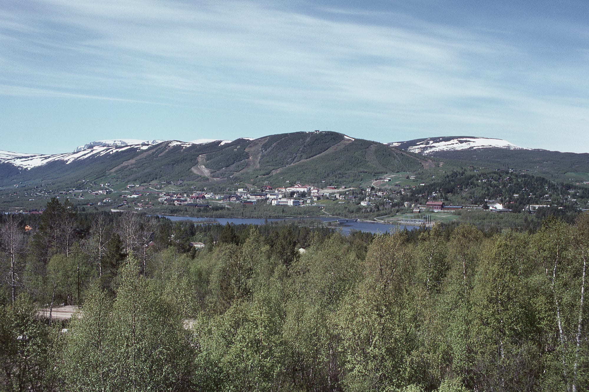
Small town beside a lake below a rounded, ski-run-scarred hill, with snow-patched mountains behind and birch woods in front

Oslo & Eastern Norway, Norway

Geilo

Geilo in early summer. (Giorgio Galeotti / Wikimedia Commons · CC BY-SA 4.0)

A ski resort town in the upper Hallingdal valley, about 800 metres up on the edge of the Hardangervidda plateau, roughly halfway between Oslo and Bergen. A handful of farms until the Bergen Line arrived, it grew into the country's first skiing resort and is still one of its largest, busy with skiers in winter and walkers and cyclists in summer.

Neighbourhoods

  • Geilo centre and the station
    • First-time visitors
    • Close to public transport

    The small centre around the railway station on the Bergen Line, mostly a group of large wooden buildings holding the tourist information, supermarkets, sports shops, cafés and restaurants. The slopes on the town side of the valley rise just behind, and a floodlit cross-country track starts nearby.

    Open in Maps
  • Geilolia
    • Families
    • Ski school
    • Summer activities

    The ski area across the valley from the centre, with the easier green and blue runs and the main ski school. In summer it becomes a summer park, with downhill biking, canoe hire and a climbing park in the trees.

    Open in Maps
  • Havsdalen
    • Skiing
    • Cabins

    The ski area over the back of the mountain from the town, part of the same resort, surrounded by holiday cabins — Geilo is known for some of the most expensive cabins in Norway.

    Open in Maps

Things to do

Skiing and the mountains around town

  • Geilo's alpine slopesattraction

    Several small ski centres sold as one resort, with about 20 lifts and slopes on both sides of the valley and in Havsdalen; the season runs from late autumn until late April.

    Open in Maps
  • Cross-country trailstrail

    An extensive network of about 220 km of prepared tracks across the plateau, with a stretch under floodlights for evening skiing.

    Open in Maps
  • Hallingskarvet National Parkpark

    A national park established in 2006 around the Hallingskarvet range, which stretches from Geilo towards Finse and rises to 1,933 metres.

    Open in Maps
  • Ustedalsfjordenpark

    One of the three lakes that lie beside the town.

    Open in Maps

Short trips from the town

  • Hardangervidda National Parkpark

    Norway's largest national park, a high plateau of lakes and moorland stretching south and west of Geilo.

    Open in Maps
  • Rallarvegentrail

    The construction road built in 1902–04 for the Bergen Line, now a popular cycling route in summer from Haugastøl past Finse towards Flåm.

    Open in Maps
  • Finseattraction

    A mountain hamlet on the Bergen Line, beside the lake Finsevatnet and the highest station of the Norwegian railway system, near the Hardangerjøkulen glacier.

    Open in Maps
  • Torpo Stave Churchlandmark

    A stave church built in 1192 in the small village of Torpo, beside the main road down Hallingdal towards Oslo.

    Open in Maps

Eat and drink

Long-standing places and food districts in Geilo. Hours, ratings and directions come from your maps app, always current.

Food in Geilo

  • Geilo centreneighborhood

    The cafés and restaurants of the town centre, gathered with the supermarkets and shops in the wooden buildings around the station.

    Open in Maps
  • Skarvegrottarestaurant

    A restaurant at the Geilolia ski area and summer park, across the valley from the centre.

    Open in Maps

Experience Geilo

History

Geilo takes its name from the old farm Gjeilo, from a word for a fenced road for cattle. Until the early 20th century the upper part of Hallingdal, the Ustedalen valley, had only a few scattered farms, and there was no road across Hardangervidda to the west, only hiking trails.

The Bergen Line changed everything. Work crews laying track from both ends met at nearby Ustaoset in 1907, the station at Geilo, first named Gjeilo, opened on 21 December 1907, and in November 1909 the whole railway between Bergen and Oslo was opened. The station was built on the Gjeilo farm, and the tourist trade began when Lars Gjeilo fitted out rooms for a handful of guests arriving by train. The railway made Geilo the first skiing resort in the country, and it drove the growth of the village, its tourism and some small industry.

In the late 20th century Geilo emerged as one of the most popular winter resorts in Norway, within reach of both Oslo and Bergen. National Road 7 now runs through the town over Hardangervidda to the west, the lifts have spread across both sides of the valley and over the mountain into Havsdalen, and the hillsides have filled with holiday cabins — some among the most expensive in the country.

Culture & Customs

Skiing is the town's reason for being. Alpine slopes on both sides of the valley, an extensive cross-country network of around 220 km of tracks, telemark skiing, dog sledging, ski orienteering and kiting fill the long season, which runs from late autumn until late April. Evening skiing is possible most evenings, and a floodlit track and a biathlon range lie just behind the centre.

The town belongs to Hallingdal, a valley with strong folk traditions: the halling, an acrobatic dance in which the dancer kicks down a hat held high on a stick, the Hallingdal style of rosemaling, the painted floral decoration on furniture, and stave churches such as the one at Torpo, built in 1192, further down the valley. The bunad, the folk costume, is worn on Constitution Day and at weddings.

In summer the mood changes. Geilo becomes a base for hiking on Hallingskarvet and Hardangervidda, mountain biking on downhill trails and woodland paths, rafting, fishing and glacier walks, and for the Rallarvegen, the old navvies' road beside the railway that is now a popular cycle route.

Daily Life

Geilo had about 2,600 inhabitants in 2025. It is a centre within Hol Municipality and is primarily a ski resort, and its population is small beside the numbers of visitors who arrive in the winter season from December to Easter, when they greatly outnumber the locals.

The centre is compact: a few large wooden buildings hold supermarkets, sports shops, a newsagent, the tourist information and a police station, and a cinema, library and school stand a short way down the road. Geilohallen, the large sports hall, is home to the local sports club. Tourism is the main business, alongside some small industry, and after Gol, Geilo is the most important centre for services and trade in Hallingdal.

The town lies at about 800 metres above sea level, and its daily rhythm follows the snow: long months of skiing and busy holiday weeks, then quieter summers of walkers and cyclists passing through on the road and railway between Oslo and Bergen.

Food

Food in Geilo is that of the mountain resorts of Hallingdal and inland Norway. Everyday staples include smørbrød, open sandwiches with several toppings, and brunost, the sweet brown cheese made from caramelised whey, eaten with bread. Lefse, a soft flatbread made from potato, milk or cream and flour, is a staple of the valleys.

Hearty home dishes suit the climate: fårikål, the mutton and cabbage stew counted as the national dish, in autumn; and kjøttkaker, meat patties of ground beef and onion in brown sauce.

Most eating out happens in the town centre, where cafés and restaurants share the wooden buildings with the supermarkets, and at the ski areas, where restaurants serve skiers on the slopes. Many visitors self-cater in cabins, stocking up in the supermarkets around the station. To drink, akevitt, flavoured with caraway or dill, is the traditional Norwegian spirit; supermarkets sell only beer up to 4.75 per cent, and wine and spirits come from the state Vinmonopolet shops or the bars and restaurants.

Planning tools

Budget

Geilo is a resort and prices follow the seasons: rooms and cabins cost most in the winter holidays and at Easter, when visitors greatly outnumber the locals, and lift passes and ski hire add to the bill. Self-catering cabins and supermarket food are the main ways to save.

Daily Budget Midrange
USD 220–420 (mid-range room or cabin, restaurant dinners, a lift pass and ski hire)
Daily Budget Shoestring
USD 90–150 (cabin share or budget room, supermarket food, cross-country skiing on free trails)

Wine, spirits and strong beer are sold only at Vinmonopolet shops; buy supplies before arriving at a cabin on the mountain.

Best Time to Visit

December to Easter is the main ski season, though at this height the ski season does not end until late April or early May. Summer and autumn bring hiking, mountain biking, fishing, rafting and the Rallarvegen cycle route, when the town is far quieter.

Suggested Number of Days

Two or three days give a taste of the slopes or the plateau. A ski holiday or a summer visit with longer walks and bike rides on the mountain plateaus needs more time.

First Visit
2–3 days
With Surroundings
4–7 days

Transportation

The centre and the town-side slopes can be walked; the ski areas across the valley and over the mountain are easiest to reach by car. National Road 7 runs through the town, west over Hardangervidda to the Hardanger fjord and east down Hallingdal; a road also leads south to Numedal over Dagali.

In bad winter weather Road 7 can be closed between Haugastøl and Vøringsfossen; winter tyres are needed in winter conditions.

Airport & Station Connections

Geilo station is on the Bergen Line, and trains take about three hours 40 minutes from Oslo, with services on to Bergen and a nightly sleeper. By road it is about 250 km from Oslo, roughly halfway to Bergen, and buses run from both cities. The small airport at Dagali, 24 km away, closed to commercial flights in 2003 and now takes only private aircraft; the nearest airport with scheduled flights is Fagernes, and most visitors fly into Oslo or Bergen.

Walkability

The centre is small and easy to walk, with the station, shops and the town-side lifts close together. Geilolia across the valley, Havsdalen and the cabin areas are spread out on the hillsides, so a car is useful. Snow and ice cover paths for much of the year.

Safety

Norway has among the lowest crime rates in the world. In Geilo the risks come from the mountains: fast-changing weather and white-outs on the open plateau, avalanche terrain off the marked pistes, cold, and winter driving on Road 7.

Check the weather and the avalanche forecast before skiing off-piste or crossing the plateau, and carry warm layers in every season. Check current official travel advice before travelling.

Climate

A mountain climate at about 800 metres: summers are mild and winters are mostly cold with stable weather. On average there is a solid snow cover for about 150 days each winter, and cold weather allows snow-making on the slopes.

Summer
mild — the July average in Geilo is about 11°C, and the weather on the surrounding mountains is changeable
Winter
cold and snowy — the January average in Geilo is about −8°C, with solid snow cover for about 150 days

Local Customs

Geilo is a resort community: in the winter season visitors greatly outnumber the people who live here, and many of them own cabins. Ski culture runs through the town, from evening skiing on floodlit tracks to ski orienteering and dog sledging. On 17 May the bunad, the folk costume, is worn for Constitution Day.

Keep to prepared tracks and slopes in poor weather; wine, spirits and strong beer are sold only at Vinmonopolet shops.

Common Payment Methods

The currency is the Norwegian krone (NOK). Cards and the Vipps app are used for almost everything, although staffed shops have been required by law to accept cash since October 2024. Contactless card payment is widespread.