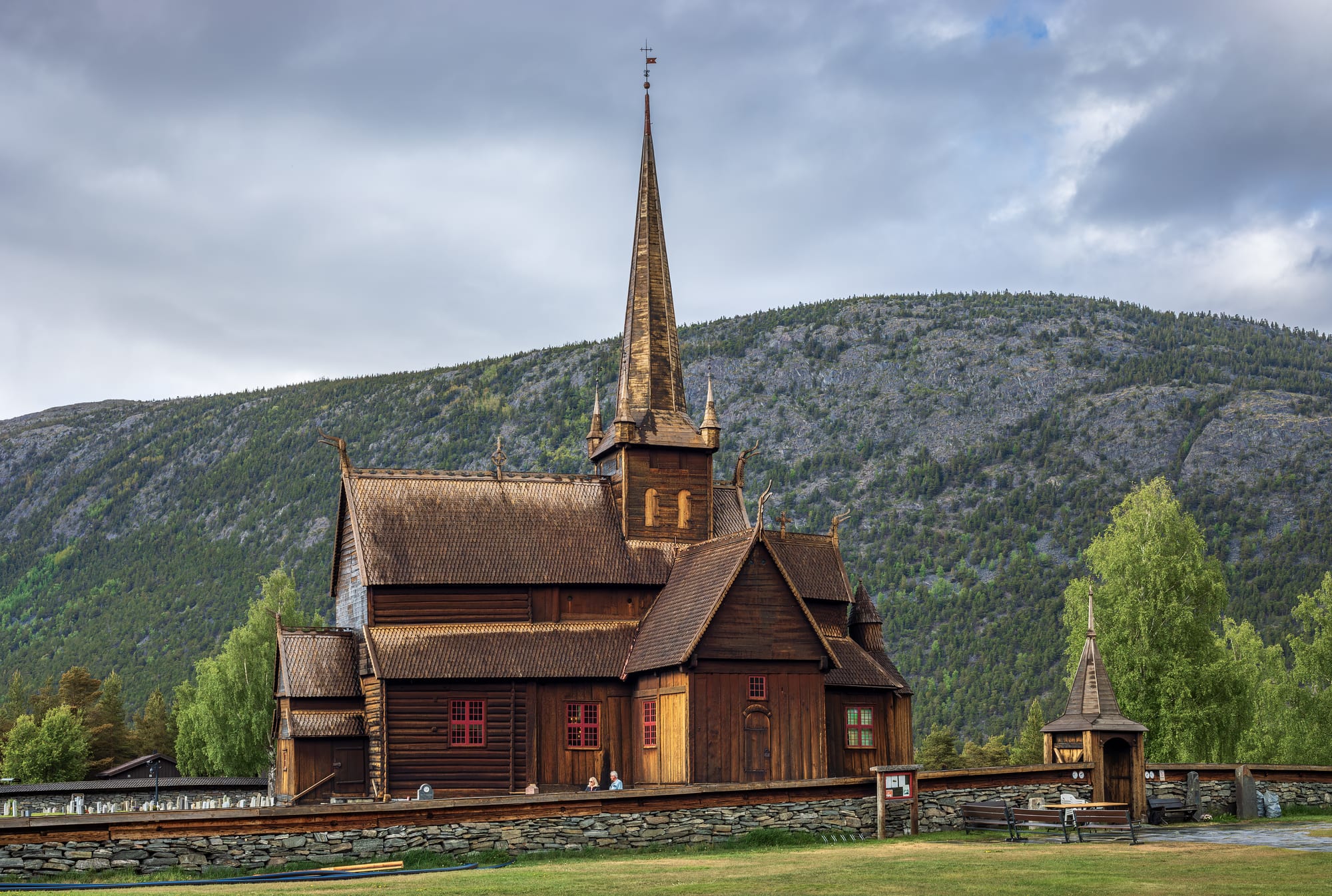
Dark timber stave church with a tall spire and dragon-head gables behind a stone wall, below a forested mountainside

Oslo & Eastern Norway, Norway

Lom

Lom Stave Church in the village of Fossbergom. (Ximonic (Simo Räsänen) / Wikimedia Commons · CC BY-SA 4.0)

A mountain village, properly called Fossbergom, where the Bøvra river falls into the Otta in the upper Gudbrandsdal country. Home to a 12th-century stave church, it sits at the junction of the roads between eastern and western Norway, and it is now the main gateway to Jotunheimen, Galdhøpiggen and the Sognefjell mountain road.

Neighbourhoods

  • Fossbergom village centre
    • First-time visitors
    • Museums
    • Best for food

    The small village on the south bank of the Otta, around the roundabout where the roads from Stryn, Sogn and eastern Norway meet. The stave church, the mountain museum, the stone centre and the bakery beside the Prestfossen falls are all within a few minutes' walk.

    Open in Maps
  • Bøverdalen
    • Hiking
    • Scenic drives

    The 50-km valley of the Bøvra river running south-west from the village towards the Sognefjell, followed by the mountain road. Scattered farms line the valley floor, and side roads climb to the high plateaus where the routes to Galdhøpiggen begin.

    Open in Maps

Things to do

In the village

  • Lom Stave Churchlandmark

    One of the largest stave churches in Norway, built around 1170 from timber felled in 1157–58 and enlarged in the 17th century, and one of very few to keep its original medieval roof crest with a dragon head.

    Open in Maps
  • Norwegian Mountain Museummuseum

    Norsk Fjellmuseum, founded in 1994 in the village's mountain centre, the authorised visitor centre for the Jotunheimen, Breheimen and Reinheimen national parks, with prehistoric skis, shoes and a bow found in melting ice.

    Open in Maps
  • Fossheim Stone Centremuseum

    Fossheim Steinsenter, a geological museum with one of the larger collections of minerals and precious stones in the country.

    Open in Maps
  • Prestfossenviewpoint

    The waterfall in the middle of the village where the Bøvra pours into the Otta, the falls that give Fossbergom its name.

    Open in Maps

Short trips from the village

  • Galdhøpiggentrail

    Norway's and Northern Europe's highest mountain, 2,469 metres, first climbed in 1850 by three men from Lom; the summit is reached from the Juvvass plateau or, on guided trips in season, across the Svellnosbreen glacier from Spiterstulen.

    Open in Maps
  • Glittertindtrail

    The second-highest mountain in Norway, 2,452 metres, in Jotunheimen National Park; its summit glacier has shrunk in recent years.

    Open in Maps
  • Sognefjellsvegenviewpoint

    The highest mountain pass road in Northern Europe, opened in 1938, a national tourist road climbing from Lom over the Sognefjell to 1,434 metres at Fantesteinen and down to the Sognefjord.

    Open in Maps
  • Jotunheimen National Parkpark

    The national park of Norway's highest mountains, created in 1980, with more than 250 peaks above 1,900 metres and wildlife including reindeer, moose, lynx and wolverine live; more than half of it lies in Lom.

    Open in Maps

Eat and drink

Long-standing places and food districts in Lom. Hours, ratings and directions come from your maps app, always current.

Lom classics

  • Bakeriet i Lomcafe

    The village bakery and café just off the roundabout, with sweet and savoury baking and outdoor seating looking over the Prestfossen rapids.

    Open in Maps
  • Fossbergom village centreneighborhood

    The handful of cafés, cafeterias and restaurants around the road junction, busiest in summer when the mountain roads are open.

    Open in Maps

Experience Lom

History

The name Lom comes from Loar, the flat land by the site of the stave church, and the village itself takes its name, Fossbergom, from Prestfossen, the waterfall where the Bøvra pours into the Otta. The first church here was a small wooden post church built in the 11th century. Around 1160–1170 it was torn down and replaced by a larger stave church, whose timber has been dated by its tree rings to 1157–58; the building was restored and enlarged in the 17th century by a builder who also worked at Vågå and Ringebu.

For centuries the valley lay on a trade route across the mountains between the west coast and the inland valleys: fish and salt came east, and grain went west to the coast. The municipality's coat of arms shows three water scoops, once used to irrigate the farmland.

Tourism came with the climbers. In 1850 three men from Lom — the guide Steinar Sulheim, the teacher Lars Arnesen and the church warden Ingebrigt Flotten — made the first ascent of Galdhøpiggen. A road was built up to the Juvvass plateau in 1936, and in 1938 the Sognefjell road opened across the mountains to the Sognefjord, making Lom a summer junction between eastern and western Norway. Jotunheimen National Park was established in 1980, and the Norwegian Mountain Museum opened in the village in 1994.

Culture & Customs

Lom's identity is bound up with its mountains. Seven of Norway's ten highest peaks, Galdhøpiggen and Glittertind among them, lie within the municipality, and more than half of Jotunheimen National Park. The Norwegian Mountain Museum tells the story of people in the high country, including the first mountain tourists, with prehistoric skis, shoes and a bow preserved in the ice, and it serves as the visitor centre for the Jotunheimen, Breheimen and Reinheimen national parks.

The stave church is the village's landmark and still its parish church, one of the largest of its kind and among the very few to keep its medieval dragon-head roof crest. The church holds 17th- and 18th-century paintings by the local artist Eggert Munch and carved acanthus work on the pulpit, and the bunad, the folk costume, is worn on Constitution Day and at weddings.

Galdhøpiggen was first climbed by local men, one of them a guide, and guided summit trips across the glacier still run in the main season. A small glacier ski centre by the Juvvass plateau, the highest in Scandinavia, usually runs from late May into October, and the Sognefjell road, a national tourist road, brings a steady stream of visitors through in summer.

Daily Life

Fossbergom, at 382 metres above sea level in the Otta valley, had 863 people at the start of 2025. It is the administrative centre of Lom Municipality and its main population centre, and a large share of the residents work in tourism, commerce and services. Other settlements in the municipality include Garmo, Bøverdalen and Lia.

The year has two rhythms. From May to September the mountain roads open, the bakery, cafés, campsites and lodges fill, and traffic heading between eastern and western Norway passes through the roundabout at the centre of the village. From autumn to spring the Sognefjell road is closed, the road up to the Juvvass plateau shuts, and Lom returns to being a quiet rural community.

Daily services — the shops, the municipal offices and the church — are concentrated in the village, and longer journeys mean the 60-km trip down the valley to the railway at Otta.

Food

Lom lies in the upper Gudbrandsdal country, the valley that gave its name to Gudbrandsdalsost, the most popular kind of brunost, the brown whey cheese. The modern firm, rich version is attributed to the milkmaid Anne Hov, who in 1863 began adding cream to the whey and boiling it down in an iron pot at a mountain farm near Gålå.

Everyday food here is that of inland Norway: lefse, a soft flatbread made from potato, milk or cream and flour, and home dishes such as fårikål, the mutton and cabbage stew counted as the national dish, in autumn, and kjøttkaker, meat patties of ground beef and onion in brown sauce.

The village bakery, just past the roundabout, serves sweet and savoury baking, with outdoor seating looking over the rapids. With few shops in the mountains, the village is the place to buy bread and supplies before heading into Jotunheimen, and in summer the cafés fill with travellers crossing between eastern and western Norway.

Planning tools

Budget

Lom is a small mountain village, and prices are those of rural Norway — lower than Oslo for rooms but high for meals out. Campsites, cabins and staffed mountain lodges in Jotunheimen keep a walking trip affordable by Norwegian standards, and self-catering from the village shops saves most.

Daily Budget Midrange
USD 200–380 (mid-range room or mountain lodge, café lunches and dinners, a hire car)
Daily Budget Shoestring
USD 85–140 (campsite or cabin, supermarket food, the summer bus)

Buy food in the village before heading into the mountains, where there are few shops.

Best Time to Visit

June to September, when the Sognefjell road and the road up to the Juvvass plateau are open and the high routes to Galdhøpiggen are walkable; summers are often sunny. The mountain road is closed from October or November until about the end of April or early May, and the village is quiet in winter.

Suggested Number of Days

One or two days cover the village and a drive over the Sognefjell. Three to five allow for a summit or a few days walking in Jotunheimen; the weather on the high routes decides the number.

First Visit
1–2 days
With Surroundings
3–5 days

Transportation

Lom sits on a main road junction: Route 15 leads west to Stryn and the fjords and east down the valley, and County Road 55, the Sognefjell road, leads south-west over the mountains to Sogn. A car is the practical way to reach the trailheads; buses are few, and some run only in July and August.

Check road status before setting out: the Sognefjell road and the road up to the Juvvass plateau close for much of the year, and mountain driving needs care in snow.

Airport & Station Connections

The nearest railway station is at Otta, on the line between Oslo and Trondheim, about 60 km away; buses cover the rest of the journey. From the west, a summer-only bus crosses the Sognefjell from Luster. Most visitors arrive by car.

Walkability

The village centre is tiny and easily walked: the stave church, the museums, the bakery and the falls are within a few minutes of each other. Everything beyond — the valley farms, the plateaus and the national parks — needs a car or a long walk.

Safety

Norway has among the lowest crime rates in the world. In and around Lom the hazards are the mountains: fast-changing weather, snow possible even in summer above 2,000 metres, glacier crossings and long, exposed days on high routes. Moose on inland roads are a danger at dusk.

Cross glaciers only with a guide, carry warm layers and check the weather before high walks. Check current official travel advice before travelling.

Climate

An inland climate with very little precipitation — about 321 mm a year in Fossbergom — cold winters, warm summers and large differences between day and night temperatures in summer. The surrounding mountains are much colder and have more precipitation, and snow can fall above 2,000 metres even in summer.

Summer
often sunny, with daytime temperatures typically between 14 and 25°C; nights are much cooler
Winter
cold and dry in the valley — the 24-hour average in Fossbergom is about −10°C in January — and the mountains are colder still

Local Customs

Lom is a farming and tourism community where outdoor life comes first. The right to roam allows walking and wild camping in the open mountains, and the stave church is still the parish church of Lom. The bunad, the folk costume, comes out on 17 May.

Wine, spirits and strong beer are sold only at Vinmonopolet shops, so buy before travelling into the mountains; ask before photographing people at church.

Common Payment Methods

The currency is the Norwegian krone (NOK). Cards and the Vipps app are used for almost everything, although staffed shops have been required by law to accept cash since October 2024. Contactless card payment is widespread.