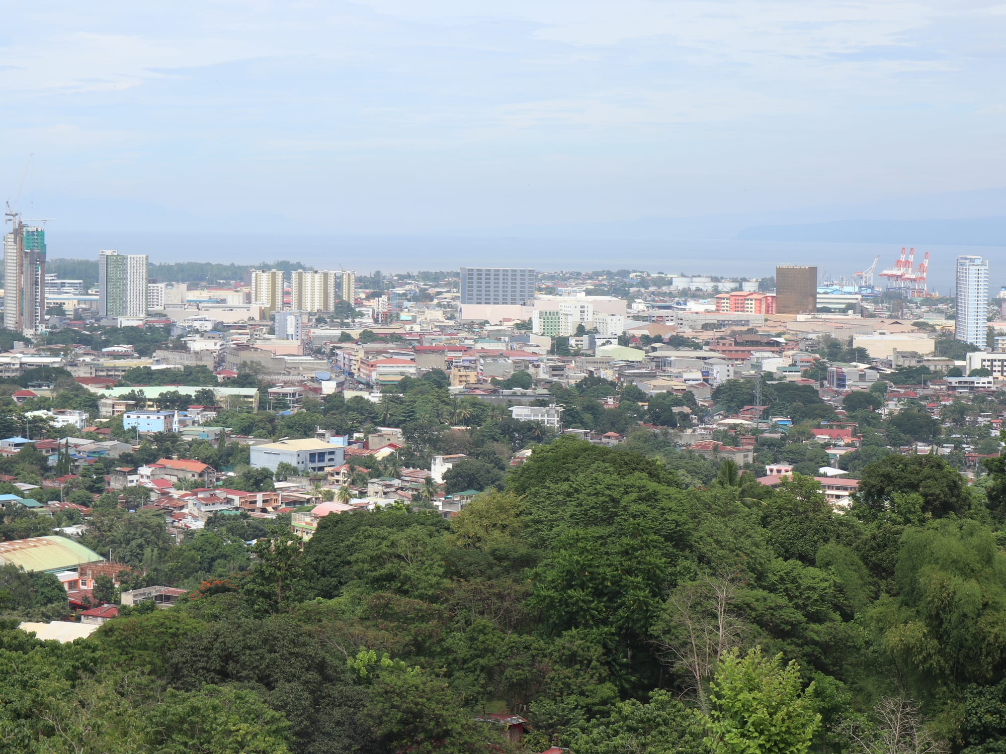
A low-rise tropical city seen from a green wooded ridge, with towers and port cranes along the shore of a wide bay under hazy hills

Mindanao, Philippines

Cagayan de Oro

Cagayan de Oro and Macajalar Bay seen from the ridge above the city. (patrickroque01 / Wikimedia Commons · CC BY-SA 4.0)

The main city of northern Mindanao, on Macajalar Bay where the Cagayan de Oro River meets the sea. A Spanish mission town that grew into a port, university centre and regional capital, it is known for white-water rafting on the river above the city, for its August festival, and as the gateway to the Bukidnon highlands and the island of Camiguin.

Neighbourhoods

  • Divisoria and the old centre
    • First-time visitors
    • Historic district
    • Close to public transport

    The heart of the city on the west bank of the river, built around a long central plaza and the cathedral. Government offices, old shophouses, hotels and cheap eateries are within a few blocks, and the plaza fills with food stalls and families in the evening.

    Open in Maps
  • Lapasan and the Limketkai area
    • Shopping
    • Best for food
    • Hotels

    The commercial strip east of the river along Claro M. Recto Avenue, with the city's largest shopping centres, chain restaurants, cinemas and much of its mid-range hotel stock. It is convenient rather than characterful, and easy to reach by jeepney.

    Open in Maps
  • Carmen
    • Local life
    • Markets
    • Quiet and residential

    A large district on the higher ground west of the river, residential and busy, with its own market and eateries. The main road out towards the airport and the west coast runs through it, and the ridge above gives the standard view over the city and the bay.

    Open in Maps
  • Macasandig and Balulang
    • Quiet and residential
    • Riverside

    Upriver neighbourhoods on both banks, a mix of subdivisions, schools and older riverside barangays. Some of the worst flooding of 2011 happened here, and stretches of riverbank have since been cleared and rebuilt.

    Open in Maps
  • Gusa and Cugman
    • Quiet and residential
    • Beaches

    The eastern coastal stretch towards Misamis Oriental, where the city thins out into housing estates, resorts and schools along the shore of Macajalar Bay, with the road to Balingoan and the Camiguin ferry running through.

    Open in Maps

Things to do

Landmarks and historic sites

  • Saint Augustine Metropolitan Cathedrallandmark

    The seat of the archdiocese beside the old plaza, rebuilt after the Second World War on the site of the mission church that founded the town.

    Open in Maps
  • Gaston Parkpark

    The square facing the cathedral, laid out in the Spanish period as the town's plaza and still the place where the city gathers for fiestas and public events.

    Open in Maps
  • Plaza Divisoriapark

    A long strip of park running through the old centre, also called the Golden Friendship Park, laid out as a firebreak in the early twentieth century and lined with monuments, benches and evening food stalls.

    Open in Maps
  • Macahambus Caveattraction

    A cave and a deep sinkhole on the upland edge of the city, beside the hill where Filipino forces defeated American troops in June 1900.

    Open in Maps

The river and the outdoors

  • Cagayan de Oro Riverattraction

    The river that gives the city its name, whose rapids upstream are the base of a white-water rafting industry that has become the city's signature activity.

    Open in Maps
  • Mapawa Nature Parkpark

    A large private tract of forest, river and waterfalls in the hills south of the city, used for walking, canyoning and horse riding.

    Open in Maps
  • Gardens of Malasag Eco-Tourism Villagepark

    A hillside park above Cugman with gardens, replica tribal houses and a view over Macajalar Bay towards Camiguin.

    Open in Maps

Markets and shopping

  • Cogon Marketmarket

    The city's main public market, opened in 1959, a dense grid of stalls selling fish, meat, fruit, dried goods and cooked food, busiest in the early morning.

    Open in Maps

Short trips from the city

  • Camiguinattraction

    The volcanic island across Macajalar Bay, reached by ferry from Balingoan about two hours east by bus, with hot springs, waterfalls and the White Island sandbar.

    Open in Maps
  • Mount Kitangladtrail

    A high forested massif in Bukidnon, protected as a natural park and sacred to the Higaonon and Talaandig, with guided climbs arranged through local communities.

    Open in Maps
  • Maria Cristina Fallsattraction

    A large twin waterfall on the Agus River at Iligan, west along the coast, harnessed for hydroelectric power and viewed from a park above the gorge.

    Open in Maps
  • Malaybalayattraction

    The capital of Bukidnon on the cool plateau south of the city, known for its pine-shaded monastery, coffee and the Kaamulan gathering of the province's tribes.

    Open in Maps

Seasonal events

  • Higalaay FestivalAugust, around the feast of Saint Augustine on the 28th

    The city fiesta around the feast of Saint Augustine, with street dancing, a river float procession, trade fairs and concerts; the name comes from the Cebuano word for friendship.

  • KaamulanFebruary to March

    The gathering of Bukidnon's Indigenous peoples in Malaybalay, a few hours south, with rituals, music and dress from seven tribal groups.

  • Holy WeekMarch or April

    Processions, vigils and closed offices across the city, followed by an exodus to the beaches and to Camiguin over the long weekend.

  • Christmas seasonDecember

    Lanterns, dawn Masses in the weeks before Christmas and carol competitions, in a country with one of the longest Christmas seasons anywhere.

Eat and drink

Long-standing places and food districts in Cagayan de Oro. Hours, ratings and directions come from your maps app, always current.

Cagayan de Oro classics

  • Sinuglaw and grilled fishrestaurant

    The northern Mindanao pairing of grilled pork belly with kinilaw, raw fish cured in vinegar and calamansi, is on most local menus alongside grilled tuna and squid.

    Open in Maps
  • Binakimarket

    Steamed sweet corn cakes wrapped in corn husk, sold warm by vendors at the markets and bus terminals, a speciality of the corn-growing highlands inland.

    Open in Maps

Food districts and markets

  • Cogon Marketmarket

    Cooked-food stalls, fruit, fish and dried goods in the city's main market, where the cheapest and most local eating is done.

    Open in Maps
  • Divisoria night stallsneighborhood

    The central plaza turns into an open-air eating place after dark, with barbecue grills, rice meals, halo-halo and families out walking.

    Open in Maps
  • Lapasan and Recto Avenueneighborhood

    The modern restaurant strip around the shopping centres, with Filipino chains, Korean and Japanese places, bakeries and coffee shops.

    Open in Maps

Experience Cagayan de Oro

History

The settlement that became Cagayan de Oro began upriver. Huluga, on bluffs above the Cagayan de Oro River, was an inhabited site long before the Spanish arrived, and the village there, known to the missionaries as Himologan, stood under its own datu when Augustinian Recollect friars reached it in 1622. Its chief, Datu Salangsang, was persuaded in 1626 to move the community downstream to the present site, where a church was built beside what is now Gaston Park and the town of Cagayan took shape as a mission centre and small port on Macajalar Bay.

Its position on the north coast, at the mouth of a navigable river and at the foot of the route into the Bukidnon plateau, made it a natural trading point. The Philippine–American War reached it in June 1900, when Filipino forces defeated American troops at Macahambus Hill, the first Filipino victory of that campaign. Under American rule the town became the capital of Misamis Oriental, gained schools and a pier, and drew migrants from the Visayas. It was occupied during the Second World War and badly damaged in 1945, and rebuilt afterwards; a city charter followed in 1950, when the name Cagayan de Oro was formally adopted.

Post-war growth was fast. The port, the highway system, Xavier University and a string of colleges, and industries on the coast east and west of the city turned it into the commercial centre of northern Mindanao. In December 2011 Tropical Storm Washi, known locally as Sendong, sent the river over riverside barangays at night and killed more than a thousand people in Cagayan de Oro and neighbouring Iligan, the worst disaster in the city's history and the reason for much of the flood engineering and relocation housing visible today.

Culture & Customs

The city calls itself the City of Golden Friendship, and its August fiesta, Higalaay, takes its name from the Cebuano word for friend. The festival marks the feast of Saint Augustine, the town's patron, and combines Mass and procession with street dancing, a float parade on the river, fairs and concerts — the one week when the whole city is on the streets. Holy Week and the long Christmas season, with its dawn Masses, are the other fixed points of the year.

Cagayan de Oro is a Cebuano-speaking, Catholic, migrant city: most families trace themselves to the Visayas or to the surrounding Misamis countryside within a few generations, and it sits at the meeting point of settler, Indigenous and Muslim Mindanao. Higaonon and other lumad communities from the hills come down to the markets, students arrive from across the region, and there is a small Muslim population with its own quarter and mosques. That mixture is reflected in the university museums and in the crafts and textiles sold in town.

It is above all a student city — Xavier University, founded by Jesuits, and a dozen other colleges give it a young population — and an outdoors one, with the river, the highlands and the bay close enough to structure weekends. Basketball courts fill every barangay, karaoke carries from houses on Sunday afternoons, and the evening promenade along the plaza is a long-standing habit.

Daily Life

About 740,000 people live in the city, which spreads from the bay up onto the plateau behind and is the largest urban centre in northern Mindanao. Divisoria and the old streets west of the river hold the offices and the markets; Lapasan and the Recto Avenue corridor hold the malls and much of the formal employment; and the population lives in a wide ring of barangays, from middle-class subdivisions in Macasandig to dense, poorer settlements on the riverbanks and coastal strips.

The economy rests on the port and the regional trade it carries, on food processing and light manufacturing in the coastal industrial zones, on outsourcing offices that employ thousands of young English speakers on night shifts, and on education and healthcare for the whole of the region. Agriculture in the hinterland — pineapple, corn, coconut, sugar and coffee from Bukidnon — moves through the city, and tourism adds the rafting operators and the traffic heading on to Camiguin.

Daily life runs early: markets before dawn, school and office traffic that gridlocks the bridges by seven, and a second peak in the evening when the plaza and the malls fill. Flooding remains the central civic issue, along with housing for families relocated after 2011, water supply, and the congestion that comes with a city growing faster than its road network.

Food

Cagayan de Oro eats Cebuano-style food with a strong bias towards grilled meat and fresh fish from Macajalar Bay. Kinilaw — raw fish cured in vinegar and calamansi with onion, ginger and chilli — is the regional dish, and sinuglaw combines it with grilled pork belly in one plate. Lechon, whole roast pig, appears at every celebration, and barbecue stalls grilling pork skewers, chicken intestines and sausages over coals are a fixture of the evening streets. Rice, always, and a soup such as tinola or the sour sinigang beside it.

The inland highlands supply the city's other specialities. Binaki, sweet steamed corn cakes in husk wrappers, are sold warm at terminals and markets; Bukidnon coffee and pineapple come down the same road; and highland vegetables fill the Cogon Market stalls. From Camiguin come pastel, soft buns filled with milk-and-egg yema, sold in boxes all over the city, and lanzones when the crop comes in.

Merienda between meals means puto and other rice cakes, bibingka, banana cue, and halo-halo shaved ice with beans, fruit and purple ube. The student population supports a large cheap-eating scene of carinderias, milk-tea shops and late-night silog plates of garlic rice, egg and cured meat, while the malls carry the national chains and Korean and Japanese restaurants.

Planning tools

Budget

Cagayan de Oro is inexpensive by Philippine standards and good value for food and hotels, since it is a business and university city rather than a resort. The main discretionary costs are rafting trips on the river, hire cars or vans for the Bukidnon highlands, and the ferry and accommodation if the trip is extended to Camiguin.

Daily Budget Midrange
USD 65–140 (mid-range hotel, restaurant meals, a rafting trip or a day tour to the highlands)
Daily Budget Shoestring
USD 25–40 (guesthouse or dorm, carinderia meals, jeepneys and buses)

Rooms and buses fill during the August fiesta, Holy Week and the Christmas weeks, when booking ahead matters more than at any other time.

Best Time to Visit

The city has no strong dry season, but February to May is generally the calmest and best for the rivers and the coast. August brings the Higalaay fiesta and the city at its liveliest. Rafting runs through the year, with higher and faster water after heavy rain and gentler conditions in the drier months. The wettest and stormiest period is around November to January.

Suggested Number of Days

The city itself is compact and a day or two covers it. Most visitors use it as a base, and adding the rivers, the highlands inland or the islands off the coast lengthens the stay to four or five days.

First Visit
1–2 days
With Surroundings
4–5 days

Transportation

Jeepneys run fixed numbered routes across the city for a few pesos and are the standard way to move between Divisoria, Lapasan and Carmen. Motorela three-wheelers cover shorter local trips, taxis are metered, and Grab works here. Long-distance buses to Iligan, Bukidnon, Davao and Balingoan leave from the Agora and Westbound terminals on either side of the city.

Traffic on the bridges and along Recto Avenue is heavy at peak hours, so allow far longer than the distance suggests.

Airport & Station Connections

Laguindingan Airport, about 45 kilometres west of the city in Misamis Oriental, serves Cagayan de Oro with flights from Manila, Cebu and other domestic points; shuttle vans and buses take roughly an hour into the centre. Ferries from Manila, Cebu, Bohol and Iloilo call at the port, and buses connect the whole of northern and central Mindanao. Citizens of the EU, the UK, the US, Canada, Australia, New Zealand and many other countries enter the Philippines visa-free, usually for 30 days, with a passport valid for six months and an onward ticket; arriving passengers register online through the government's eTravel form shortly before the flight.

Walkability

The old centre around Divisoria, the cathedral and the plaza is flat and walkable, and the riverside and the plaza strip are pleasant in the early morning and evening. Elsewhere the city spreads out along wide, hot roads with uneven pavements and fast traffic, and the gap between the centre and the Lapasan shopping strip is more comfortable by jeepney than on foot.

Safety

Cagayan de Oro is among the calmer parts of Mindanao, together with Davao, Siargao and Camiguin, and normal city precautions are enough: watch for pickpockets in markets and on crowded jeepneys, and use Grab or a metered taxi late at night. The travel warnings that cover parts of Mindanao apply to the west and centre of the island rather than here. The serious hazards are natural — the Cagayan de Oro River floods heavily in extreme rain, as it did in 2011, and earthquakes occur.

Monitor PAGASA for storms, keep away from volcanic danger zones, take dengue precautions year-round, and do not travel to the Sulu provinces or the Zamboanga peninsula. Check current official travel advice before travelling.

Climate

Tropical and humid all year, tempered a little by sea breezes on the bay and by the hills behind. Rain is spread through the calendar rather than concentrated in one monsoon, and the city lies south of the usual typhoon track, though storms that do reach this coast can bring severe flooding down the river.

Summer
hot and humid, about 25–33°C from March to May, with afternoon and evening showers
Winter
warm, about 24–31°C from November to February, the wettest and stormiest stretch

Local Customs

The city is Cebuano-speaking and Catholic, with English widely understood. Older people are greeted with po and opo in Tagalog or with the mano gesture of touching an elder's hand to the forehead, and titles such as ma'am and sir are used freely. Dress modestly in churches. Karaoke is a social institution, and an invitation to eat is meant seriously and is best not refused outright.

Tipping is not expected, though rounding up a fare or leaving small change is normal; ask before photographing people, market stalls or children.

Common Payment Methods

The currency is the Philippine peso. Cards work in hotels, malls and larger restaurants, and e-wallets are widely used, but jeepneys, motorelas, markets, carinderias and small shops are cash only. Cash machines are easy to find in the centre and the malls, with low per-transaction limits and withdrawal fees.