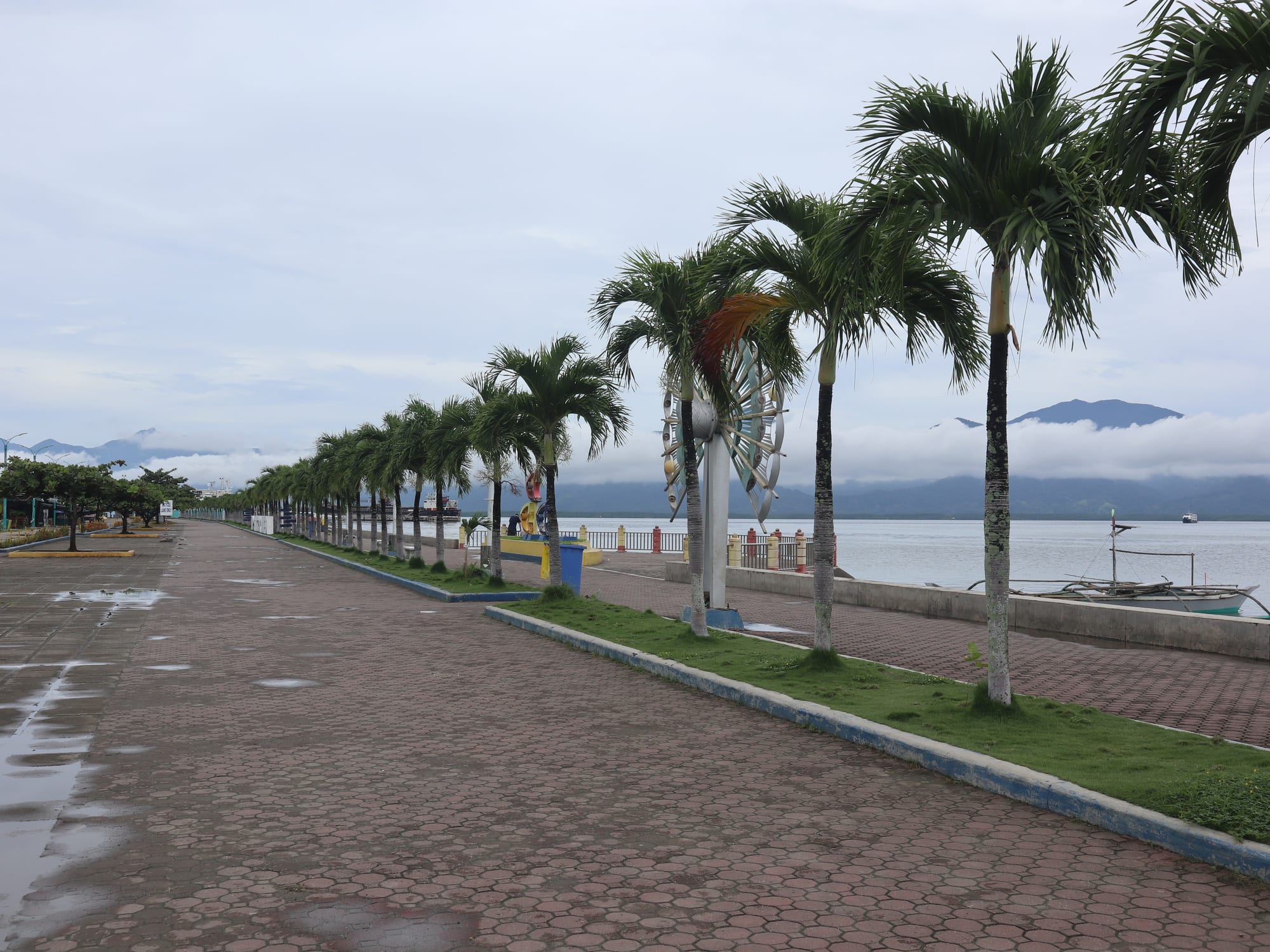
A wide paved promenade lined with palm trees beside a grey bay, with mountains and low cloud on the far shore

Palawan & Mimaropa, Philippines

Puerto Princesa

The baywalk along Puerto Princesa Bay, with the hills of the mainland across the water. (Patrickroque01 / Wikimedia Commons · CC BY-SA 4.0)

The capital and main airport city of Palawan, on a deep bay on the island's eastern coast. Founded as a Spanish settlement in 1872 and rebuilt after heavy damage in the Second World War, it is a low-rise provincial city of wide avenues and a long baywalk, better known as the gateway to the underground river and the islands of Honda Bay than for itself.

Neighbourhoods

  • The city centre and Rizal Avenue
    • First-time visitors
    • Best for food
    • Close to transport

    The main axis of the city, running from the airport down towards the bay, lined with hotels, restaurants, banks, tour offices and shops. The cathedral, the provincial capitol and the city's markets are within a short ride, and most visitors base themselves along it.

    Open in Maps
  • The baywalk and the port
    • Sunsets
    • Evening walks
    • Seafood

    The reclaimed waterfront on Puerto Princesa Bay, with a paved promenade, food stalls and open ground where families gather in the evening, and the ferry pier a short way along the shore.

    Open in Maps
  • Sabang
    • Beaches
    • Nature
    • Quiet

    A coastal barangay about 80 km away by road on the far side of the mountains, facing the South China Sea. It is the landing point for boats to the underground river and has a long beach and a scattering of resorts, with a slow pace that has little in common with the city.

    Open in Maps
  • Santa Lourdes and the Honda Bay side
    • Island trips
    • Close to the wharf

    North of the centre, where the road reaches the wharf used for boats to the islands of Honda Bay. It is a strip of small resorts, boat operators and roadside eateries rather than a district in its own right.

    Open in Maps
  • Irawan and the western barangays
    • Quiet and residential
    • Nature

    Inland and west of the built-up area, the city spreads into farmland and forest, with wildlife facilities, penal-farm land and villages along the road that crosses Palawan to the west coast.

    Open in Maps

Things to do

In the city

  • Puerto Princesa Cathedrallandmark

    The Neo-Gothic Immaculate Conception cathedral near the port, the mother church of the Apostolic Vicariate of Puerto Princesa and the city's most recognisable building.

    Open in Maps
  • Plaza Cuartellandmark

    A small park in the old Spanish garrison ground behind the cathedral, with a memorial to the American prisoners of war killed here on 14 December 1944.

    Open in Maps
  • Puerto Princesa Baywalkpark

    The promenade along the bay, busiest in the evening, with food stalls, benches and views across the water to the mountains.

    Open in Maps
  • Puerto Princesa International Airporttransit hub

    The province's main airport, unusually close to the centre of the city, with flights from Manila, Cebu and other Philippine cities.

    Open in Maps

Wildlife and the edges of the city

  • Palawan Wildlife Rescue and Conservation Centerattraction

    A government centre on the edge of the city, long known as the crocodile farm, which breeds and rehabilitates saltwater and Philippine crocodiles and other native wildlife.

    Open in Maps
  • Iwahig Prison and Penal Farmattraction

    An open penal colony authorised under American rule in November 1904, where inmates farm a very large area of land south-west of the city.

    Open in Maps
  • Honda Bayattraction

    The shallow bay north of the city, scattered with small islands and sandbars and reefs, visited on boat trips from the wharf at Santa Lourdes.

    Open in Maps

Beaches and the coast

  • Sabang Beachbeach

    A long grey-sand beach on the South China Sea coast of the city, in the barangay where boats leave for the underground river.

    Open in Maps
  • Nagtabon Beachbeach

    A cove on the west coast of the city, reached by a winding road through the hills, with surf in the monsoon months and a few small resorts.

    Open in Maps

Short trips from the city

  • Puerto Princesa Subterranean River National Parkpark

    A navigable river running through a limestone cave to the sea, inscribed as a UNESCO World Heritage Site in December 1999 and voted one of the New 7 Wonders of Nature in 2012; entry is by boat from Sabang, permits are limited each day and are arranged in advance.

    Open in Maps
  • Ugong Rockattraction

    A limestone outcrop in Tagabinet with caves, a scramble to the top and a zip line, usually visited on the way to or from the underground river.

    Open in Maps
  • Narraneighborhood

    A farming and fishing town south along the coast, with beaches, the Rasa Island bird sanctuary offshore and a quieter side of Palawan.

    Open in Maps

Seasonal events

  • Feast of the Immaculate ConceptionDecember

    The city's patronal feast, centred on the cathedral, with Masses, processions and street celebrations in the days around it.

  • Holy WeekMarch or April

    Processions and church services fill the city, offices close and Filipino visitors fill the flights and the beaches; it is the busiest week of the year in Palawan.

Eat and drink

Long-standing places and food districts in Puerto Princesa. Hours, ratings and directions come from your maps app, always current.

Markets and food districts

  • Puerto Princesa public marketmarket

    The main market on the northern side of the centre, where fish, squid and crab come in from the bay alongside rice, tropical fruit, dried fish and cashews.

    Open in Maps
  • Rizal Avenueneighborhood

    The city's main street, with the greatest concentration of restaurants, bakeries and cafés, from Filipino grills to Vietnamese, Korean and Italian cooking.

    Open in Maps
  • The baywalk food stallsneighborhood

    Open-air stalls and barbecue grills along the waterfront where the city eats in the evening, cheaply and outdoors.

    Open in Maps

Palawan dishes to look for

  • Chao longrestaurant

    Vietnamese-style beef noodle soup, sold across the city under this name and associated with the Vietnamese refugees who settled in Palawan; it is eaten with crusty bread.

    Open in Maps
  • Inihaw na isda and seafoodrestaurant

    Whole fish, squid, prawns and crab grilled over charcoal with calamansi and a soy-and-vinegar dip, from the boats working the bay and Honda Bay.

    Open in Maps
  • Tamilok and other local tastesrestaurant

    The mangrove shipworm eaten raw with vinegar, along with crocodile meat and Palawan honey, sold as local curiosities in city restaurants.

    Open in Maps
  • Palawan cashewsmarket

    Roasted and candied cashews and cashew tarts, the province's best-known souvenir, sold in the market and in shops across the city.

    Open in Maps

Experience Puerto Princesa

History

Puerto Princesa was founded on 4 March 1872 as a Spanish settlement on a deep, sheltered bay chosen as a naval and administrative base for a province Spain had never really controlled. The name honoured a Spanish princess — most accounts point to Infanta Eulalia, a daughter of Queen Isabella II — and within months the bay had become the centre of Spanish naval operations in the province. Taytay, further north, remained the capital until the American period. Puerto Princesa stayed small and malarial for decades, a garrison and a port on the edge of the empire.

American rule after 1898 brought the institutions that still shape the city's edges — above all the Iwahig Penal Colony, authorised in November 1904 a short way south-west, where prisoners farmed instead of being confined in cells. The Second World War brought the city its darkest episode: on 14 December 1944, as American forces approached, Japanese troops killed 139 of the American prisoners of war held in the city; eleven escaped. A memorial in Plaza Cuartel marks the massacre. The town was also bombed heavily, and little of the Spanish-era fabric survived.

Post-war Puerto Princesa grew as Palawan's administrative centre and as the destination for migrants from the Visayas and Luzon moving to a province with land to spare; Vietnamese refugees settled in the province in the same decades, leaving a culinary mark that remains. It became a chartered city in 1970 and was later reorganised with an enormous municipal area reaching from coast to coast. From the 1990s the city built a reputation for environmental policy — tree planting, bans and clean-up campaigns — and the inscription of the subterranean river as a UNESCO World Heritage Site in 1999 made tourism the driver of its growth.

Culture & Customs

Puerto Princesa is a city of arrivals. Its population came from across the Philippines — Ilonggo, Cebuano, Tagalog and Ilocano speakers, alongside Cuyonon families from the Cuyo islands who were among the earliest settlers, and Palawan's Indigenous peoples, the Tagbanwa, Palaw'an and Batak, who live mostly in the province's interior and southern uplands. Tagalog and English are the common languages of the city, with Cuyonon and Visayan spoken at home. The mixture gives the place a mild, unhurried character without the strong regional identity of older Philippine cities.

Catholicism provides the public calendar, from the cathedral's feast of the Immaculate Conception in December to Holy Week processions, and provincial anniversaries fill the capital with delegations from Palawan's municipalities. Evenings belong to the baywalk, where families, students and food stalls fill the promenade after the heat has gone.

The city takes its environmental reputation seriously and publicly: rules on wildlife products and waste are visible in signs and enforcement, and residents are proud of the city's environmental reputation. Vietnamese noodle soup, sold as chao long, has become a local speciality through the refugee settlement in the province, one of the clearest examples of how recent the city's traditions are and how readily it absorbs them.

Daily Life

About 316,000 people live in Puerto Princesa, the figure the 2024 census gives, in a city whose boundaries take in farmland, forest and two coastlines as well as the built-up area around the bay; by land area it is the second largest city in the Philippines after Davao, and thinly settled over most of it. About three-quarters of the population lives in the city proper on the shores of the bay. Most residents live in the barangays along the main road and the bay, in low buildings of concrete and iron sheet.

Government, tourism and trade drive the economy. Provincial and city offices, the courts, schools and the island's main hospitals are here; hotels, tour operators, vans and boats employ thousands, and the airport is the hinge of the whole province's travel. Fishing supplies the markets, and farming — rice, cashew, coconut, fruit — continues in the outer barangays, alongside the penal farm at Iwahig.

Days begin early and traffic builds on Rizal Avenue through the morning; afternoons are hot and slow; evenings fill the baywalk and the barbecue stalls. Power and water supply, waste disposal and the state of the roads are constant local complaints, and growth pressures — land prices, building on the shoreline, and the strain that visitor numbers put on the parks — are argued over in a city that has staked its reputation on conservation.

Food

Seafood is the everyday food. Fish, squid, prawns and crab from the bay and Honda Bay are grilled over charcoal as inihaw, served with rice, calamansi and a soy-and-vinegar dip; sinigang, the sour tamarind broth, and kinilaw, raw fish cured in vinegar and calamansi with ginger and chilli, are on most menus. Dried fish with rice and eggs is a standard breakfast.

The city's distinctive dish came with the Vietnamese refugees who settled in Palawan. Chao long, the local name for beef noodle soup, is eaten with crusty bread across the city and has become as much a Puerto Princesa habit as anything older. Palawan also offers the things visitors are urged to try once — tamilok, the mangrove shipworm eaten raw with vinegar, and crocodile meat from the wildlife centre's stock — alongside honey gathered in the forests.

Cashews are the province's signature product, roasted, candied and baked into tarts and sold in every market and souvenir shop; the market also stacks dried fish, seaweed, and fruit from the outer barangays. National staples fill the rest of the table: adobo, pancit noodles, lechon at celebrations, pandesal from the bakeries in the morning, and halo-halo, shaved ice with milk, beans, jelly and fruit, in the afternoon heat. Beer, calamansi juice and buko, young coconut, are the usual drinks.

Planning tools

Budget

Puerto Princesa is the cheapest of Palawan's visitor towns, with a wide range of hotels and inns, ordinary city prices for food, and public transport that costs very little. The expenses are the tours: the underground river with its permit, boat and transfers, island-hopping in Honda Bay, and the long van rides north to El Nido or the coast.

Daily Budget Midrange
USD 80–160 (hotel, restaurant meals, a day tour or two, van transfers)
Daily Budget Shoestring
USD 30–50 (guesthouse or dorm, market and carinderia meals, tricycles and jeepneys, a shared tour)

Arrange the underground river well ahead, since daily numbers are capped, and draw cash here before heading to smaller towns where machines are scarce.

Best Time to Visit

December to May is the dry season and the time for boats and beaches, with March to May the calmest and hottest. January and Holy Week are the busiest. From about June to October the southwest monsoon brings heavy rain and rough water on the west coast, which can close the underground river and Honda Bay trips for days at a time.

Suggested Number of Days

Two or three days is enough for the city and a day trip or two. Four or five suits anyone adding the coast or using the city as the start of a longer journey up the island, and weather makes a spare day worthwhile.

First Visit
2–3 days
With Surroundings
4–5 days

Transportation

Multicabs and jeepneys run along the main roads for a few pesos, and tricycles cover everything else within the built-up area; motorbikes and cars are rented easily. Vans leave from terminals on the edge of the city for El Nido, Port Barton, San Vicente and the southern towns, and boats for Honda Bay go from the wharf at Santa Lourdes. The city covers a very large area, so distances are longer than they look.

Agree tricycle fares in advance, and book van seats the day before in the busy season; journeys to Sabang and the north take longer than the distance suggests.

Airport & Station Connections

Puerto Princesa International Airport sits in the middle of the city, a few minutes from Rizal Avenue, with flights from Manila, Cebu and other Philippine cities. Ferries from Manila and Iloilo call at the port. By road, El Nido is about 270 km north, roughly five to six hours by van, and Sabang about 80 km away by road over the mountains, around two hours.

Walkability

The centre around Rizal Avenue and the baywalk can be walked, and the cathedral, plaza and main shops are close together, but the city sprawls over a huge municipal area and most journeys are by tricycle or jeepney. Pavements are uneven or missing on smaller streets, traffic is constant on the main road, and the heat makes long walks tiring.

Safety

Puerto Princesa is one of the calmer cities in the Philippines and serious crime against visitors is uncommon, though petty theft and overcharging occur where tourists gather. The practical risks are road traffic, sun and heat, mosquito-borne illness, and rough seas on boat trips in the monsoon months. Medical care is the best on the island but limited by city standards elsewhere.

Use registered boats and tour operators, keep valuables out of sight on beaches and in tricycles, and use repellent, since dengue occurs year-round. Monitor PAGASA for storms, keep away from volcanic danger zones, take dengue precautions year-round, and do not travel to the Sulu provinces or the Zamboanga peninsula. Check current official travel advice before travelling.

Climate

Tropical, hot and humid all year, with a dry season from about December to May and a wet southwest monsoon from June to October. Palawan lies south of the main typhoon belt and is hit less often than Luzon, though storms do reach the island, and the west coast is wetter and rougher than the bay side in the monsoon.

Summer
hot and humid, typically 28–34°C, driest from March to May
Winter
warm and mostly dry, 24–31°C, with breezier seas from December to February

Local Customs

The city is Catholic, relaxed and used to visitors, and dress is casual, though swimwear stays at the beach and shoulders are covered in church. Elders are addressed respectfully with po and opo, and greetings come before requests. Palawan takes its environmental rules seriously, with restrictions on taking shells, coral or wildlife products out of the province.

Do not buy souvenirs made from coral, turtle shell or other wildlife, keep to marked paths in the parks, and tip guides and boat crews modestly.

Common Payment Methods

The currency is the Philippine peso. Hotels, malls, larger restaurants and tour agencies take cards, and cash machines are far more common here than anywhere else on the island, but tricycles, jeepneys, market stalls, small eateries and most boat operators want cash. It is the practical place to withdraw money before travelling on into Palawan.