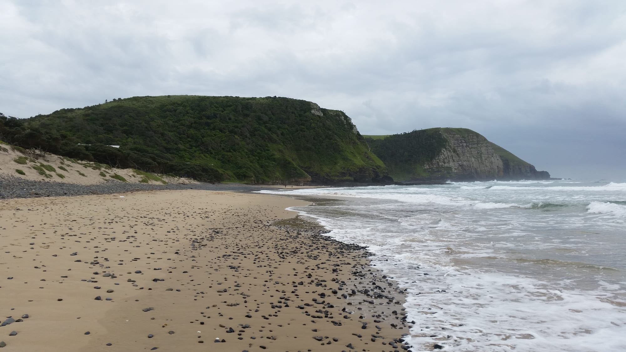
A pebble-strewn sand beach curving towards steep green headlands that end in cliffs above breaking surf

The Eastern Cape & the Wild Coast, South Africa

Coffee Bay

The beach at Coffee Bay, with the grassy headlands and cliffs of the Wild Coast beyond it. (hermansmit / Wikimedia Commons · CC BY-SA 3.0)

A small village on the Wild Coast of the Eastern Cape, where green hills of the former Transkei break off in cliffs above the Indian Ocean. A handful of backpacker lodges, a beach at a river mouth and the sea arch of Hole-in-the-Wall a short way down the coast draw travellers to a shore of scattered Xhosa homesteads and long, empty walks.

Neighbourhoods

  • The bay and the village
    • First-time visitors
    • Beaches
    • Backpackers

    The cluster of lodges, a few shops and a police station at the end of the tarred road, set behind the beach where a small river reaches the sea. Everything a visitor needs is within a few hundred metres, and the hills rise straight up behind.

    Open in Maps
  • The hillside homesteads
    • Local life
    • Walks and viewpoints

    Round huts and small rectangular houses in painted turquoise and white are scattered across the grassy slopes above the bay, with cattle paths running between them. Walking through them is the ordinary way to reach the headlands and the next beaches.

    Open in Maps
  • The coast towards Hole-in-the-Wall
    • Walks and viewpoints
    • Quiet and residential

    South of the village the shore runs past cliffs, coves and the Mpako River mouth to the sea arch, along a rough road and a well-walked coastal path. A few lodges and homesteads sit along the way, and the country is open grassland above the sea.

    Open in Maps

Things to do

The coast

  • Coffee Bay beachbeach

    A sheltered sand beach at the river mouth between headlands, used for swimming, surfing and fishing and backed by the village.

    Open in Maps
  • The coastal walk to Hole-in-the-Walltrail

    A walk of several hours along cliffs, beaches and river mouths between the village and the sea arch, usually done with a local guide.

    Open in Maps

Nearby on the Wild Coast

  • Hole-in-the-Walllandmark

    A tidal island pierced by a wave-cut arch at the mouth of the Mpako River, about 8 km south along the coast, called esiKhaleni, the place of sound, in isiXhosa, after the roar of the sea through the hole.

    Open in Maps
  • Mdumbibeach

    A beach in a sweeping bay about 24 km north along the coast, lined with shady milkwood trees and Xhosa huts below rolling green hills, with good, uncrowded surf.

    Open in Maps

Short trips inland

  • Mthathaattraction

    The main town of the former Transkei, about 80 km inland, with the region's shops, hospitals and airport and the museum devoted to Nelson Mandela.

    Open in Maps
  • Qunuattraction

    The village south-west of Mthatha where Nelson Mandela spent his childhood and where he is buried, about 110 km from the coast by road.

    Open in Maps

Eat and drink

Long-standing places and food districts in Coffee Bay. Hours, ratings and directions come from your maps app, always current.

Eating in the village

  • The lodge kitchens and village cafésneighborhood

    Almost all cooked meals here come from the backpacker lodges and a few small cafés, serving fish, curries, braais and Xhosa dishes on set menus.

    Open in Maps
  • Fish and seafood from the shoreneighborhood

    Line fish, mussels and crayfish gathered or caught locally are the village's speciality, grilled simply or cooked into a potjie stew.

    Open in Maps
  • Spaza shops and the roadsidemarket

    Small general shops sell bread, maize meal, tinned food and cool drinks, and women sell fruit, vegetables and amagwinya, fried dough balls, along the road.

    Open in Maps

Experience Coffee Bay

History

The coast between the Kei and the Mzimvubu has been Xhosa-speaking country for centuries, farmed and grazed by Thembu and Bomvana communities living in scattered homesteads rather than towns. The shore was known to sailors long before it was settled by outsiders: the run of reefs and river mouths wrecked enough ships to give the coast its name, and survivors of those wrecks were sometimes absorbed into local communities.

The village's own name is explained by one of those wrecks: a ship is said to have lost a cargo of coffee beans off this shore, and the coffee trees that grew from them gave the bay the name it has carried since 1893. British control reached this country late, after the frontier wars of the nineteenth century, and the district was governed as part of the Transkeian Territories, where colonial magistrates ruled alongside chiefs. Under apartheid the area became part of Transkei, declared a nominally independent homeland in 1976 and recognised only by South Africa and the other homelands. It was reincorporated into South Africa in 1994 as part of the new Eastern Cape province.

Coffee Bay itself grew from a trading store and a pair of resort hotels into a stop on the backpacker route, with lodges on the bay and shuttles up to the N2. Tourism now sits alongside farming and remittances as one of the few sources of cash in the district. Roads, electricity and water have arrived unevenly, and plans for coastal development and for a new highway through the region have been contested for years by residents and conservationists alike.

Culture & Customs

Life here is Xhosa life, and specifically that of the former Transkei, where custom remained strong through the homeland years. Homesteads hold extended families, cattle are wealth as well as food and are central to ceremony, and decisions are taken in meetings with headmen and chiefs as well as elected councillors. Ancestors are addressed at important moments, and church-going and traditional practice usually run side by side in the same family.

Visitors see some of this from a distance. Young men returning from initiation in the hills, their faces and bodies marked with white clay, are a familiar sight in the winter and summer seasons; the rite is private and not a spectacle. Women wear printed cloth, headscarves and beadwork for ceremonies, and the ochre-dyed dress associated with the region appears at weddings and funerals.

Music and dance are part of everyday gathering rather than performance: clapping and call-and-response singing, drumming at ceremonies, and the umrhubhe mouth bow and uhadi bow that gave Xhosa music its characteristic sound. Around the lodges a second culture has grown up, of surfers, hikers and long-stay travellers, and the two meet at guided village walks, football matches on the beach and the informal economy of guiding, cooking and craft that tourism supports.

Daily Life

Only a few hundred people live in Coffee Bay itself, with a much larger population spread through the surrounding homesteads and the villages inland, in a district where poverty and poor health are pervasive. Households are often headed by women and grandparents, because many working-age adults live in Cape Town, Gqeberha or Gauteng and send money home; government grants are the other main income.

The economy is subsistence farming — maize, pumpkins, vegetables, cattle, goats and chickens — plus fishing and gathering from the shore, small shops and the lodges, which are the biggest local employer. Craft work, guiding and transport fill in the rest. There is no bank and only limited electricity supply, and mobile signal is patchy across the hills.

Days follow the light. Cattle are taken out to graze in the morning and brought back at dusk, water is fetched from taps or the river, school children in uniform walk long distances over the hills, and the minibus taxi to Mthatha leaves early and returns in the afternoon. Grant day fills the road. The persistent local issues are the state of the access road, water and electricity supply, distance from clinics and hospitals, and the argument over how far the coast should be developed.

Food

Xhosa cooking is the everyday food. Umngqusho, samp — stamped maize kernels — simmered for hours with sugar beans, is the staple dish, and umphokoqo, a dry crumbly maize porridge, is eaten with amasi, thick soured milk. Imifino, wild greens gathered from the fields, are cooked with maize meal, and amagwinya, fried dough balls sold warm from roadside tables, are the common snack. Meat is eaten mainly at ceremonies, when an animal is slaughtered for the family and the ancestors.

The sea provides the rest. Mussels are prised off the rocks at low tide, crayfish are caught in the shallows, and line fish taken from the rocks and the river mouths are grilled over coals or cooked into a potjie, the slow stew of the three-legged pot. Lodge kitchens combine the two traditions, serving seafood, curries and braais alongside samp and beans.

Umqombothi, the thick, sour home-brewed beer of maize and sorghum, is made for ceremonies and shared from a communal container, and commercial beer and brandy are sold at the shops and taverns. Tea is drunk strong and sweet throughout the day, and rooibos, the red bush tea of the Western Cape, is widely available.

Planning tools

Budget

Coffee Bay is one of the cheapest places to stay in South Africa. Dormitory beds and simple rondavels cost very little, meals are eaten where people sleep, and the walking and the beaches are free. The real costs are getting here — fuel over a long, slow road, or a shuttle from Mthatha — and guided walks or village visits.

Daily Budget Midrange
USD 90–180 (private room or rondavel at a lodge, all meals, hire car, guided walks)
Daily Budget Shoestring
USD 25–45 (dormitory bed, lodge meals, shared transport)

Draw cash in Mthatha before setting out, as card payment and cash machines are unreliable in the village, and budget for a shuttle if not driving a high-clearance vehicle.

Best Time to Visit

The Wild Coast is warmest and greenest from about November to April, the summer-rain season, with swimmable sea and thunderstorms that can make the access roads worse. May to September is drier and sunnier with cooler water and clearer air, which suits the coastal walks. December fills the lodges with South African holidaymakers.

Suggested Number of Days

Two or three days is the usual stay, given how long the journey in takes. Four to six suit walkers moving along the coast between villages. Weather and the state of the roads change the number more than anything else.

First Visit
2–3 days
With Surroundings
4–6 days

Transportation

There is no public transport for visitors beyond shared minibus taxis, which run between the village and Mthatha on their own schedule and fill before they leave. Most people drive or take a lodge shuttle from Mthatha. Within the village and along the coast, walking is the only way to move, often on paths across the hills rather than roads.

The access roads from the N2 are slow, potholed and crossed by cattle, goats and pedestrians; drive them by day only and allow far more time than the distance suggests.

Airport & Station Connections

Coffee Bay lies about 80 km from Mthatha by road, a drive that usually takes two hours or more on a narrow route through the hills. Mthatha has a small airport with flights from Johannesburg, and the N2 between East London and Durban passes through the town. Lodges run shuttles from Mthatha, which is also where the long-distance coaches stop.

Walkability

The village itself is tiny and covered on foot in minutes, and the country around it is walked rather than driven — over headlands, down to river mouths and through homesteads. There are no pavements, the paths are steep, grassy and slippery after rain, and there is no street lighting, so walking stops at dusk.

Safety

The everyday risks here are the sea and the roads rather than crime. Rip currents are strong on unguarded beaches, the cliffs are unfenced and the rock is slippery, and river mouths can run hard after rain. On the roads, livestock, pedestrians and potholes make night driving dangerous. Opportunistic theft happens, and walkers usually go with a local guide.

The Wild Coast's main risks are the roads — cattle, pedestrians and potholes — plus isolated opportunistic theft and strong rip currents on unguarded beaches. Avoid driving after dark, swim only where locals advise, walk the coast with a guide, and carry water, sun protection and cash. Check current official travel advice before travelling.

Climate

Subtropical and humid, with rain falling mostly in the warm months and a sea warmed by the Agulhas Current. In the southern hemisphere summer runs from December to February and winter from June to August; frost is unknown on this coast and mist often sits on the hills.

Summer
warm and humid, roughly 22–28°C, with heavy afternoon thunderstorms
Winter
mild and mostly dry, roughly 12–22°C, with cool nights and clear days

Local Customs

This is a deeply Xhosa part of the country, and the village sits among homesteads where traditional authority, cattle and ceremony still matter. isiXhosa is the first language of almost everyone; English is spoken at the lodges. Greetings come first in any encounter — molo to one person, molweni to several — and elders are addressed with respect.

Ask before photographing people, homesteads or ceremonies, dress modestly away from the beach, accept that initiation rites in the hills are private and not to be approached, and pay local guides directly and fairly.

Common Payment Methods

The currency is the South African rand (ZAR). Cash is the practical currency in the village: card machines depend on a mobile signal that comes and goes, and there is no reliable cash machine, so most travellers draw money in Mthatha before arriving.