A small town of white buildings and green trees spread on a dry plain, seen from a rocky ridge with flat-topped hills beyond

The Eastern Cape & the Wild Coast, South Africa

Graaff-Reinet

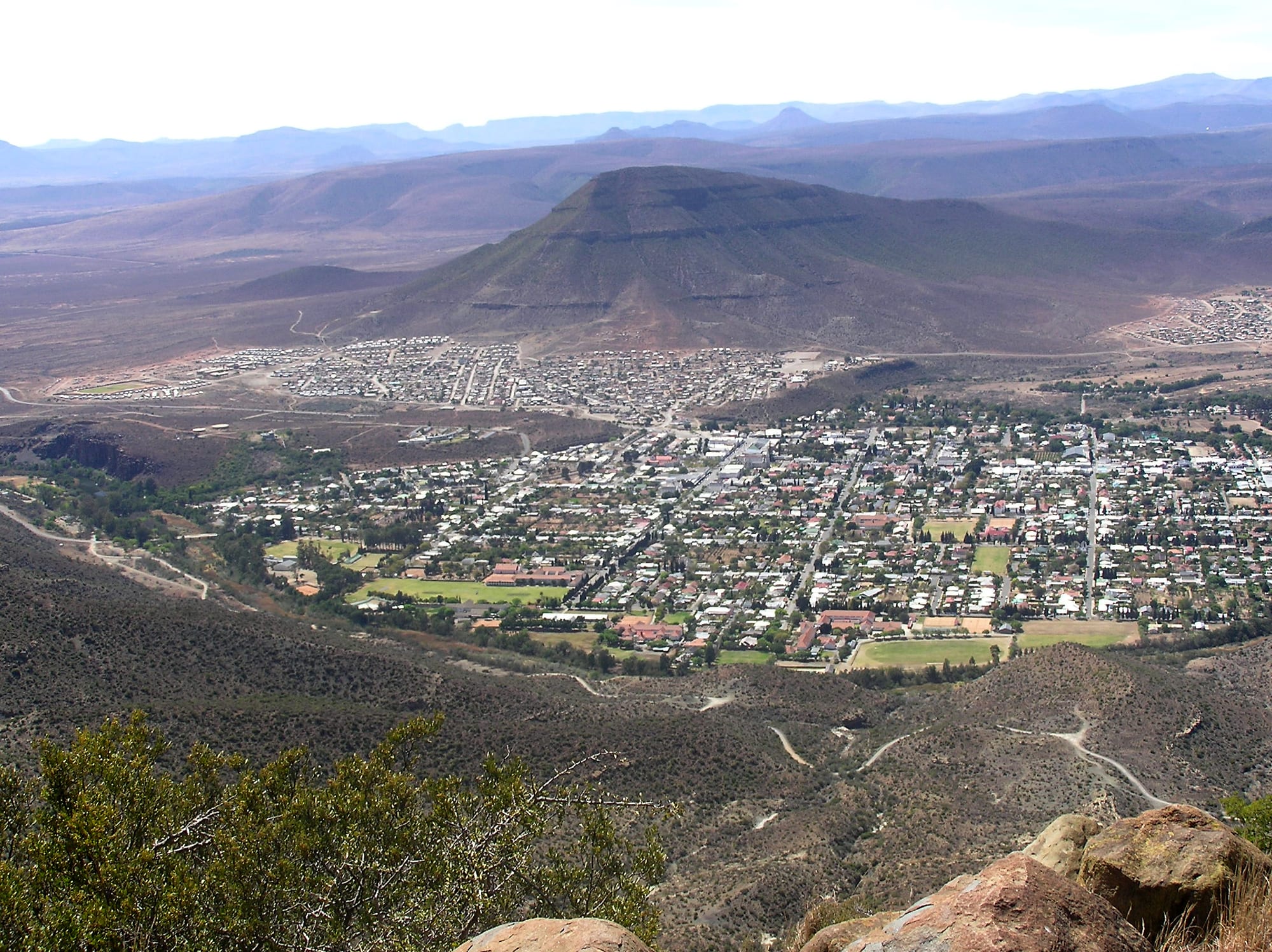
Graaff-Reinet on the Karoo plain, seen from the ridge of the Valley of Desolation in Camdeboo National Park. (Winfried Bruenken (Amrum) / Wikimedia Commons · CC BY-SA 2.5)

A Karoo town in the western Eastern Cape, founded in 1786 as a frontier outpost of the Dutch East India Company and grown around a bend of the Sundays River. Its grid of whitewashed Cape Dutch and Victorian houses, many of them declared heritage sites, is almost encircled by Camdeboo National Park, with the dolerite pillars of the Valley of Desolation on the ridge above. The town was officially renamed Robert Sobukwe Town in 2026.

Neighbourhoods

  • The historic centre
    • First-time visitors
    • Historic district
    • Architecture

    The old grid between Church Street and Somerset Street, laid out around the tall spire of the Dutch Reformed Church. Whitewashed Cape Dutch gables, flat-roofed Karoo cottages and Victorian verandas stand along wide streets, and most of the museums, guesthouses and restaurants are within a few blocks of each other.

    Open in Maps
  • Kroonvale and Umasizakhe
    • Local life
    • Quiet and residential

    The residential areas on the northern and western sides of town, separated from the old centre by the apartheid-era planning that shaped almost every South African town. Umasizakhe is the older township, with small churches, spaza shops and a long political history of its own.

    Open in Maps
  • The riverside and the park edge
    • Quiet and residential
    • Walks and views

    Where the streets run out towards the Sundays River and the boundary of Camdeboo National Park, which almost encircles the town. Pear and pecan trees, sports fields and a few lanes of older houses give way quickly to Karoo scrub and the road up to the viewpoints.

    Open in Maps

Things to do

The historic town

  • Groote Kerklandmark

    The large stone Dutch Reformed church at the head of Church Street, seating about 1,500 people, its spire closing the view up the main street.

    Open in Maps
  • Reinet Housemuseum

    The Cape Dutch parsonage of 1812, now a museum of household and rural life, with an old grape vine in the garden behind it.

    Open in Maps
  • The Drostdylandmark

    The early nineteenth-century magistrate's residence at the end of Church Street, designed by Louis Michel Thibault, who also drew Reinet House, and long since converted to other use.

    Open in Maps

Parks and viewpoints

  • Camdeboo National Parkpark

    Proclaimed in 2005 and almost entirely surrounding the town, with Karoo plains, plateau grassland, game-viewing loops and the valley viewpoints in its southern section.

    Open in Maps
  • Valley of Desolationviewpoint

    Cliffs and high columns of weathered dolerite, declared a national monument in 1935 and about 14 km from town by road, with the Camdeboo plains and the town itself laid out below.

    Open in Maps
  • Nqweba Dampark

    The dam on the Sundays River just north of town, inside the national park, whose water level rises and falls sharply with the Karoo rains.

    Open in Maps

Short trips from the town

  • Nieu-Bethesda and the Owl Houseattraction

    The house and concrete-sculpture yard made by the artist Helen Martins from the 1940s until her death in 1976, filled with owls, camels and figures built from cement and crushed glass.

    Open in Maps
  • Mountain Zebra National Parkpark

    A highland reserve created to save the Cape mountain zebra, which also holds cheetah, buffalo and antelope on its plateau grassland.

    Open in Maps

Eat and drink

Long-standing places and food districts in Graaff-Reinet. Hours, ratings and directions come from your maps app, always current.

Graaff-Reinet classics

  • Karoo lambrestaurant

    Lamb raised on the region's dry, aromatic scrub is the dish the town is known for, served roasted, grilled or in a slow potjie stew by most kitchens in the centre.

    Open in Maps
  • Church Street and Somerset Streetneighborhood

    The old centre holds nearly all the town's restaurants and coffee places, several of them in converted Cape Dutch houses with courtyards behind.

    Open in Maps
  • Karoo farm stallsmarket

    Roadside stalls on the N9 and R63 sell biltong and droëwors, preserves, honey, dried fruit and rusks made for dunking in coffee.

    Open in Maps

Experience Graaff-Reinet

History

The Cape's Dutch administration founded Graaff-Reinet in 1786 as the seat of a new frontier district, naming it for the governor Cornelis Jacob van de Graaff and his wife. It is the oldest town in the Eastern Cape and the sixth-oldest in South Africa. The site, in a loop of the Sundays River below the Sneeuberge, already lay in country used by Khoekhoe herders and San hunters and was being taken up by trekboer stock farmers moving out from the Cape.

The frontier was unruly from the start. In 1795 local burghers drove out the Company's landdrost and declared a short-lived republic, which lasted until British and then Batavian authority was restored. Through the nineteenth century the town settled into its role as the market and church centre of the Camdeboo: the Drostdy went up in the first years of the nineteenth century, Reinet House was completed in 1812, and a succession of larger churches ended with the Groote Kerk that still closes the top of Church Street. Wool from Karoo merino flocks paid for the gabled houses that give the streets their character.

The South African War of 1899–1902 divided the district, with local men on both sides. In the twentieth century apartheid planning moved Black and coloured residents to Umasizakhe and Kroonvale on the edges of town. Robert Sobukwe, founder of the Pan Africanist Congress, was born here in 1924. From the 1950s a conservation movement grew around the town, ending in the proclamation of Camdeboo National Park in 2005; protection of the old centre has left the town with more declared national monuments than any other in South Africa. In January 2026 the national government approved renaming the town Robert Sobukwe Town, a change made official the following month and opposed by many residents.

Culture & Customs

The town's public face is architectural. It has more declared national monuments than any other town or city in South Africa, and the mixture of Cape Dutch gables, flat-roofed Karoo cottages and Victorian ironwork is the reason most visitors come. The spire above Church Street sets the pace of the week for a largely churchgoing population, and the Dutch Reformed and Anglican congregations, along with independent churches in Umasizakhe, are the main social institutions alongside the schools and the sports clubs.

Two languages shape daily manners. Afrikaans is spoken by most people in the town, including the coloured community of Kroonvale, whose ancestors were among the labourers, freed slaves and Khoekhoe workers of the early district; isiXhosa is the language of Umasizakhe and of much of the surrounding farm labour force. Introductions are unhurried, and strangers are greeted in the street.

The wider Karoo has developed a strong literary and artistic identity, and Graaff-Reinet sits at its centre: the Owl House at nearby Nieu-Bethesda drew a generation of artists and writers to the district, and small galleries, craft workshops and second-hand bookshops occupy several of the old houses. Farming culture underlies everything else — sheep auctions, agricultural shows, hunting season and the endless talk of rain. Sunday lunch and the braai are the social fixtures of the weekend, and the town empties in the afternoon heat of midsummer.

Daily Life

About 35,000 people live in Graaff-Reinet and its surrounding areas, a figure that has grown as farm workers have moved into town. The centre is small and comfortable; the great majority of residents live in Umasizakhe and Kroonvale, where unemployment is high and many households depend on social grants and seasonal farm work. The gap between the guesthouse streets and the townships is as visible here as anywhere in the country.

Sheep and goat farming for wool, mohair and meat is the foundation of the district economy, with game farming and hunting alongside it. Tourism is the other pillar — guesthouses, restaurants, the museums and the national park — and it supports a good share of local jobs. Government offices, schools and the hospital make up much of the rest of formal employment.

Drought is the defining local issue. The Karoo's rainfall is unreliable, and dry years empty the Nqweba Dam and force farmers to sell stock and the municipality to restrict water; the debate over water supply, borehole use and the state of municipal infrastructure runs through local politics. Electricity interruptions have shaped business hours in recent years as they have across South Africa. The rhythm of the day is early: shops open soon after seven, the streets are quiet in the afternoon, and by nightfall the town is still.

Food

Karoo lamb is the local speciality and the reason the town appears on food itineraries. Sheep grazing on the dry, aromatic shrubs of the plains produce meat with a distinct flavour, eaten as chops off the braai, as a slow-roasted leg, or in a potjie — the three-legged cast-iron pot in which stew is cooked over coals for hours. Mutton and venison from the district's game farms appear on the same menus, along with springbok and kudu.

Everyday cooking is Afrikaans country food: pap or samp with tomato-and-onion sauce, boerewors, bobotie, pumpkin fritters, and milk tart or malva pudding afterwards. In Umasizakhe the Xhosa staples of the Eastern Cape are eaten as they are across the province — umngqusho, samp cooked with beans, umphokoqo crumbly porridge with sour milk, and meat at ceremonies. Biltong and droëwors, air-dried and spiced, are made locally and sold in butcheries and farm stalls.

Rusks — hard twice-baked biscuits dunked in coffee — are the standard breakfast of the region, and preserves, honey and dried fruit fill the farm stalls on the main roads. A few vineyards and olive groves have been planted along the Sundays River, and the restaurants of the old centre serve Cape wines by the glass. Coffee places in Church Street fill mid-morning, the town's busiest social hour.

Planning tools

Budget

Graaff-Reinet is inexpensive by South African standards outside the December and Easter holidays, when Karoo guesthouses fill with travellers breaking the drive between Johannesburg and the coast. Accommodation is mostly small guesthouses in historic houses; restaurant meals and the national park's day permits are cheap. The main cost is the hire car that almost every visitor needs.

Daily Budget Midrange
USD 120–220 (guesthouse in the old town, car hire, restaurant meals, a guided drive or a trip to Nieu-Bethesda)
Daily Budget Shoestring
USD 40–70 (backpacker or self-catering room, supermarket food, park day permit, shared fuel)

A day permit for Camdeboo National Park covers both the game-viewing loop and the road to the valley viewpoints, and the museums sell a joint ticket.

Best Time to Visit

March to May and September to November are the most comfortable months, with warm days and cold clear nights. Midsummer, from December to February, is very hot on the plains, though the viewpoints are pleasant at dawn and dusk. Winter days are sunny and mild and winter nights drop below freezing. Rain falls mostly in thunderstorms between October and March.

Suggested Number of Days

Most visits last one or two nights, which is enough for the old town and the national park. Adding the villages and reserves out on the Karoo roads stretches a stay to about three. Travellers breaking a long drive often stay a single night.

First Visit
1–2 days
With Surroundings
3 days

Transportation

The town is small enough to cross on foot, and almost everyone arrives by car. There is no local bus network; minibus taxis link the centre with the townships and run to Gqeberha and other regional towns. Trips into Camdeboo National Park and out to Nieu-Bethesda need a vehicle, and local operators run guided drives for those without one.

The road to the Valley of Desolation is tarred, but many Karoo side roads are gravel — check the surface before turning off, and watch for kudu and livestock at dusk.

Airport & Station Connections

Graaff-Reinet sits where the N9 meets the R63, roughly 250 km north-west of Gqeberha, a drive of about three hours, and a similar distance south of the N1 at Colesberg. The nearest airports with scheduled flights are at Gqeberha and East London. Intercity coaches on the Cape Town–Johannesburg and Gqeberha–Bloemfontein routes stop in or near the town.

Walkability

Very walkable. The historic grid is flat, the blocks are short and the museums, church, shops and restaurants all lie within about fifteen minutes' walk of one another. Distances to the residential areas on the edges are longer, and the park viewpoints are far beyond walking range. Streets are quiet after dark and poorly lit in places.

Safety

Graaff-Reinet is a calm country town and sees far fewer problems than the South African cities, though opportunistic theft from parked cars and houses does happen. The everyday risks are more practical: strong sun, long empty roads, and animals on the verges after dark.

Avoid driving after dark, swim only where locals advise, and hike the Wild Coast with a guide or lodge-arranged transfers. Check current official travel advice before travelling.

Climate

Semi-arid Karoo climate, with big daily swings between hot afternoons and cold nights, low humidity and around 300 mm of rain a year, most of it in summer thunderstorms. In the southern hemisphere summer falls between December and February and winter between June and August.

Summer
hot and dry — afternoons often 32–36°C, cooling sharply after sunset
Winter
sunny days around 17–20°C, with frost and sub-zero nights

Local Customs

Afrikaans is the first language of most people in and around the town, with isiXhosa widely spoken and English understood everywhere. Greetings matter: a handshake and a few words before business is normal. Dress is informal, though the older churches are still treated formally. Farming talk, rain and drought are the common subjects of conversation.

Tip about 10 per cent in restaurants and a few rand to informal car guards; ask before photographing people or their homes, especially in the townships.

Common Payment Methods

The currency is the South African rand. Cards are taken by hotels, restaurants, fuel stations and supermarkets, and ATMs are easy to find in the centre. Cash is useful for farm stalls, craft sellers, car guards and the smaller villages out in the Karoo, where card machines depend on a signal.