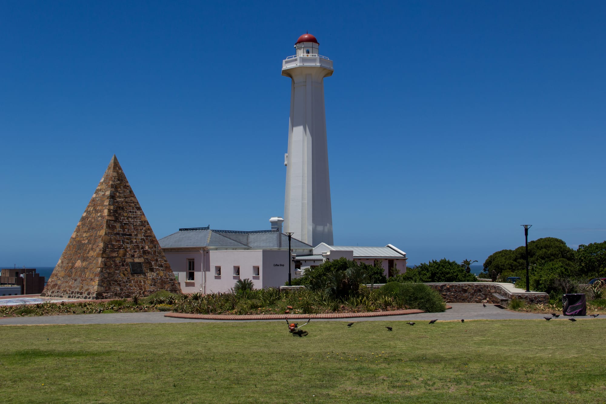
A stone pyramid and a white lighthouse with a red top standing on a grassy headland above the sea under a clear blue sky

The Eastern Cape & the Wild Coast, South Africa

Gqeberha

The stone pyramid and the Hill Lighthouse on the Donkin Reserve above the centre of Gqeberha. (Stefan Schäfer / Wikimedia Commons · CC BY-SA 3.0)

The largest city of the Eastern Cape, on Algoa Bay where the 1820 Settlers came ashore. Known as Port Elizabeth until it was renamed Gqeberha in 2021, it grew into a port and a centre of the South African motor industry, and now spreads along kilometres of swimming beaches within an hour of the elephants of Addo.

Neighbourhoods

  • Central and the Donkin
    • Historic district
    • Architecture
    • First-time visitors

    The oldest part of the city, climbing the hill above the port, with Victorian terraces, churches, the Donkin Reserve and its lighthouse and pyramid, and the Route 67 artworks. Parts are being restored while others are rundown, and the streets empty out after office hours.

    Open in Maps
  • Summerstrand
    • Beaches
    • Families
    • Close to the university

    The beachfront suburb east of the centre, facing Algoa Bay along Marine Drive, with Hobie Beach, hotels, a casino and shopping complex, and Nelson Mandela University's main campus. Most visitors stay along this strip.

    Open in Maps
  • Humewood
    • Beaches
    • First-time visitors

    The stretch of beachfront between the harbour and Summerstrand, with King's Beach, Humewood Beach, the museum and snake park, and a promenade used all day by walkers and runners.

    Open in Maps
  • Richmond Hill
    • Best for food
    • Nightlife

    A small inner suburb of old workers' cottages on the ridge above the centre, now the city's main concentration of restaurants, coffee shops and bars in a few walkable blocks.

    Open in Maps
  • Walmer
    • Quiet and residential
    • Close to the airport

    A leafy older suburb of large houses and gardens beside the airport, with shopping centres and guesthouses; the informal settlement of Walmer Township lies on its edge.

    Open in Maps
  • New Brighton and the northern areas
    • Local life
    • History

    The townships north of the centre, laid out under segregation and a stronghold of the anti-apartheid struggle, now dense residential districts with markets, taverns and a strong football and choral tradition.

    Open in Maps

Things to do

Landmarks and history

  • Donkin Reservelandmark

    The open hilltop in the centre with the 10-metre stone pyramid Sir Rufane Donkin raised in memory of his wife Elizabeth, who died in India in 1818, beside a lighthouse of 1861 and wide views over the bay.

    Open in Maps
  • Campanilelandmark

    A brick bell tower near the harbour, built in 1923 to commemorate the arrival of the 1820 Settlers, with a stair to a viewpoint over the city.

    Open in Maps
  • Fort Fredericklandmark

    A small stone fort built by British troops in 1799 above the mouth of the Baakens River, put up to block a French landing during the Napoleonic Wars.

    Open in Maps
  • Route 67attraction

    A walking trail of 67 public artworks climbing from the Campanile near the harbour to the Donkin Reserve, one for each of Nelson Mandela's years of public service.

    Open in Maps

Beaches and the bay

  • King's Beachbeach

    A long sheltered swimming beach beside the harbour, the city's busiest, with a promenade and lifeguards in season.

    Open in Maps
  • Hobie Beachbeach

    The Summerstrand beach in front of the hotels, used for sailing, paddling and windsurfing and backed by a pier and walkways.

    Open in Maps
  • Sardinia Baybeach

    A wild dune-backed beach in a marine protected area south-west of the city, with no development and strong surf.

    Open in Maps
  • Cape Recifelandmark

    The low point that closes Algoa Bay south of the city, with a lighthouse of 1849 inside a nature reserve of dunes, bush and seabirds.

    Open in Maps

Museums and parks

  • Bayworldmuseum

    The city museum complex on the Humewood beachfront, combining natural history and cultural collections with a snake park.

    Open in Maps
  • St George's Parkpark

    The city's oldest public park, with the cricket ground that staged South Africa's first Test match in 1889 and is known for the brass band that plays through matches.

    Open in Maps
  • Nelson Mandela Bay Stadiumattraction

    A stadium of overlapping white petals beside North End Lake, built for the 2010 FIFA World Cup and now used for rugby, football and concerts.

    Open in Maps

Short trips from the city

  • Addo Elephant National Parkpark

    A large national park about 70 km north, founded in 1931 to protect the last elephants of the district and now home to several hundred, along with buffalo, lion and rhino.

    Open in Maps
  • Van Stadens Wild Flower Reservepark

    A reserve of fynbos, forest and river gorge west of the city, with walking trails and flowering proteas and ericas in winter and spring.

    Open in Maps
  • Kariega (Uitenhage)attraction

    The industrial town north-west of the city, renamed from Uitenhage in 2021, built around a large Volkswagen plant and older Cape Dutch and railway buildings.

    Open in Maps

Seasonal events

  • Ironman African Championshipautumn

    A long-distance triathlon held in the city, with a sea swim off the beachfront, a bike leg along the coast road and a run through Summerstrand.

  • Cricket at St George's Parksummer, roughly November to March

    International and domestic matches at the old ground, where a brass band has played to the crowd for decades.

  • Whale and dolphin seasonroughly June to November

    Southern right and humpback whales pass through Algoa Bay in the southern winter and spring, and dolphins are seen offshore through the year.

Eat and drink

Long-standing places and food districts in Gqeberha. Hours, ratings and directions come from your maps app, always current.

Gqeberha classics

  • Richmond Hill restaurantsneighborhood

    The city's densest run of restaurants, cafés and craft-beer bars, in converted cottages on a few blocks above the centre.

    Open in Maps
  • Stanley Streetneighborhood

    The short street at the heart of Richmond Hill, lined with bistros, bakeries, delis and bars and busy in the evenings.

    Open in Maps

The beachfront and the sea

  • Summerstrand beachfrontneighborhood

    Seafood restaurants, grills and coffee shops face Hobie Beach along Marine Drive, serving line fish, calamari and prawns with a view of the bay.

    Open in Maps
  • Fish and chips at the harbour sideneighborhood

    Kiosks and casual places near the beaches sell hake and chips, calamari and snoek, the standard cheap meal of the South African coast.

    Open in Maps

Markets

  • Weekend farmers' marketsmarket

    Saturday markets in the suburbs and at the Baakens valley sell bread, cheese, preserves, coffee and cooked food from Eastern Cape producers.

    Open in Maps

Experience Gqeberha

History

Khoekhoe herders and, further east, Xhosa farmers used the country around Algoa Bay long before Europeans settled it. Portuguese navigators charted the bay in the fifteenth and sixteenth centuries and left a stone cross on a nearby headland. A British garrison built the stone Fort Frederick in 1799 above the mouth of the Baakens River, to guard Algoa Bay against a French landing during the Napoleonic Wars.

The town proper dates from 1820, when several thousand British settlers were landed here and sent inland to farm the frontier district. The acting governor of the Cape, Sir Rufane Donkin, named the new town after his wife Elizabeth, who had died in India, and raised a stone pyramid to her memory on the hill above it. Port Elizabeth grew fast as the outlet for wool from the interior, with a harbour, banks, a railway inland from 1873 and a merchant class whose villas and public buildings still define the old centre.

Industry followed in the twentieth century, above all motor assembly: General Motors and Ford built in the city and Volkswagen at neighbouring Uitenhage, now Kariega, making it the home of South Africa's motor vehicle industry. Segregation shaped the city hard — South End, a mixed district near the sea, was cleared under the Group Areas Act, and New Brighton and the northern townships became centres of resistance, producing leaders of the trade unions and the liberation movement. Since 1994 the city has been part of the Nelson Mandela Bay metro, and in February 2021 it was officially renamed Gqeberha, after the Xhosa name for the Baakens River.

Culture & Customs

The city's culture sits where Xhosa, Afrikaans and English-speaking South Africa meet. isiXhosa is spoken across the metro, Afrikaans is strong in the northern suburbs and among coloured communities, and English is the language of business and of the old settler institutions. Names on street signs and buildings have been changing since 2021, and both the old and new names remain in daily use.

Music and sport carry much of the local identity. The townships have a deep choral tradition, church and school choirs competing at a high level, alongside jazz and gospel. Cricket at St George's Park is famous for its brass band, which plays through the day's play, and rugby and football fill the World Cup stadium beside North End Lake. The city produced Sekunjalo-era jazz players, boxers and Springboks, and sport is followed across the community lines.

Public art is unusually visible. The Route 67 works climb the hill from the Donkin Reserve, marking Nelson Mandela's years of public service, and murals and memorials record the struggle history of the northern townships. The seafront shapes leisure: early-morning walkers and runners on the promenade, surf lifesaving clubs, weekend braais on the grass above the beaches and boat trips out to the seabird islands of Algoa Bay.

Daily Life

The Nelson Mandela Bay metro, of which Gqeberha is by far the largest part, has around 1.2 million people, making it the biggest urban area in the Eastern Cape. Life is divided by geography inherited from apartheid: the coastal suburbs of Summerstrand, Humewood and Walmer, the older inner districts around the centre and Richmond Hill, and the large townships to the north, where a majority of residents live and where services are thinnest.

Motor manufacturing remains the backbone of the economy, with assembly plants and a long chain of component suppliers, alongside two ports — the city harbour and the deepwater terminal at Ngqura north of it — plus food processing, call centres, a university and a growing tourism trade. Unemployment is high even by South African standards, and many households depend on grants and on work in other provinces.

Days begin early, with commuter traffic and minibus taxis heading in from the north, and end early outside the restaurant strips. Water has been the dominant local issue in recent years: the dams supplying the metro fell to critical levels in a long drought and restrictions became part of ordinary life, on top of the national electricity cuts. The wind is a constant, and locals plan beach days around it.

Food

The sea sets the menu. Line fish such as kob, yellowtail and elf come off the boats in Algoa Bay, calamari is landed along this coast and squid from the nearby harbours is a regional speciality, and hake and chips is the standard cheap meal. Seafood platters of prawns, mussels and calamari fill the beachfront restaurants, and mussels are gathered along the rocky shores.

Xhosa home cooking is the other foundation: umngqusho, samp and beans cooked slowly until soft, often described as Mandela's favourite dish; umphokoqo, a dry crumbly maize porridge eaten with sour milk; and meat from an animal slaughtered for a family ceremony. In the townships smiley, a singed and boiled sheep's head, and walkie-talkies, grilled chicken feet and heads, are sold from street grills, and shisa nyama grill houses cook meat to order.

The settler and Afrikaner traditions supply the rest: the braai as the weekend default, boerewors, biltong and droëwors, Karoo lamb from the interior, milk tart and koeksisters. Pineapples grown along the coast towards Bathurst and chicory from Alexandria are the district's crops, and local craft breweries and the fortified and table wines of the Eastern Cape and the Karoo edges round out the drinks list alongside rooibos tea.

Planning tools

Budget

Gqeberha is one of the cheaper South African cities for visitors. Beachfront hotels and guesthouses cost less than their equivalents in Cape Town, restaurant meals are inexpensive, and the beaches and the historic centre cost nothing. The main expenses are a hire car and the day permits, guided drives or lodge stays at the game reserves inland.

Daily Budget Midrange
USD 120–250 (guesthouse or beachfront hotel, restaurant meals, hire car, a day at Addo)
Daily Budget Shoestring
USD 45–75 (backpacker lodge, self-catering, shared car, beaches and free sights)

Self-drive Addo on a day permit rather than booking a guided transfer if the budget is tight, and expect prices to rise over the December school holidays.

Best Time to Visit

The city is mild all year. March to May and September to November bring settled, warm weather, thinner crowds and good game viewing at Addo, when the bush is dry. December and January are hot and busy with South African holidaymakers, and the winter months from June to August are cool, often clear and the season for whales in the bay.

Suggested Number of Days

Two days are enough for the beaches, the historic centre and a museum. Four or five suit anyone adding the game reserves inland and the coast on either side. Weather and the amount of driving planned are what change the number.

First Visit
2 days
With Surroundings
4–5 days

Transportation

The city is spread out and built around the car; most visitors hire one or use ride-hailing apps, which are cheap and widely available. Municipal buses run limited routes and minibus taxis serve residents on fixed lines rather than visitor routes. The beachfront promenade and cycle paths link the coastal suburbs, and the N2 runs through the city.

Driving is on the left; keep doors locked in traffic, avoid driving in the townships without local guidance, and use ride-hailing rather than walking between districts after dark.

Airport & Station Connections

Chief Dawid Stuurman International Airport sits about 3 km south of the centre in Walmer, with flights from Johannesburg, Cape Town and Durban and a ten- to fifteen-minute drive to the beachfront hotels. The N2 links the city west along the Garden Route — Jeffreys Bay is about 75 km away and Cape Town some 750 km — and east towards East London. Intercity coaches use the city as a hub, and a limited passenger rail service runs inland.

Walkability

Walking works within districts rather than between them. The beachfront promenade from King's Beach through Humewood to Summerstrand is several kilometres of flat, busy seafront, and Richmond Hill and the Donkin area are small and walkable by day. The centre is hilly, quiet after office hours and generally crossed by car; distances between suburbs are long.

Safety

Gqeberha has the urban crime patterns common to South African cities: muggings and theft in quiet parts of the centre, break-ins at parked cars, and higher rates of violent crime in areas well away from the tourist suburbs. The beachfront, Summerstrand, Richmond Hill and the main roads are busy and routine by day. Rip currents and cold water are a real risk on the unguarded beaches.

Violent crime rates are high, but most of it is concentrated in areas visitors do not go; the main tourist routes — Cape Town centre, the Winelands, the Garden Route, Kruger and the private reserves — are heavily travelled and generally fine with sensible precautions. Leave nothing visible in a parked car, keep the historic centre for daylight hours, use ride-hailing at night, and swim where lifeguards are on duty. Check current official travel advice before travelling.

Climate

Mild and maritime, with rain spread through the year and a strong, near constant wind that gave the city its old nickname. In the southern hemisphere summer runs from December to February and winter from June to August; frost is unknown and the sea is swimmable for much of the year.

Summer
warm and humid, roughly 18–27°C, with strong south-westerly and easterly winds
Winter
mild, roughly 9–21°C, sunny between cold fronts that bring rain and swell

Local Customs

isiXhosa, Afrikaans and English are all widely spoken, and people switch between them easily. The city calls itself friendly and the pace is unhurried; greetings come before requests, and a handshake is usual. Beach dress stays on the beach, and Sunday mornings are quiet, with churches full across the city.

Tip about 10–15 per cent in restaurants and a few rand to car guards and petrol attendants, ask before photographing people or homes, and visit the townships with a local guide rather than alone.

Common Payment Methods

The currency is the South African rand (ZAR). Cards and contactless payment work in shops, restaurants, fuel stations and at park gates, and ATMs are common in shopping centres — safer to use than street machines. Cash in small notes is needed for car guards, markets and informal traders.