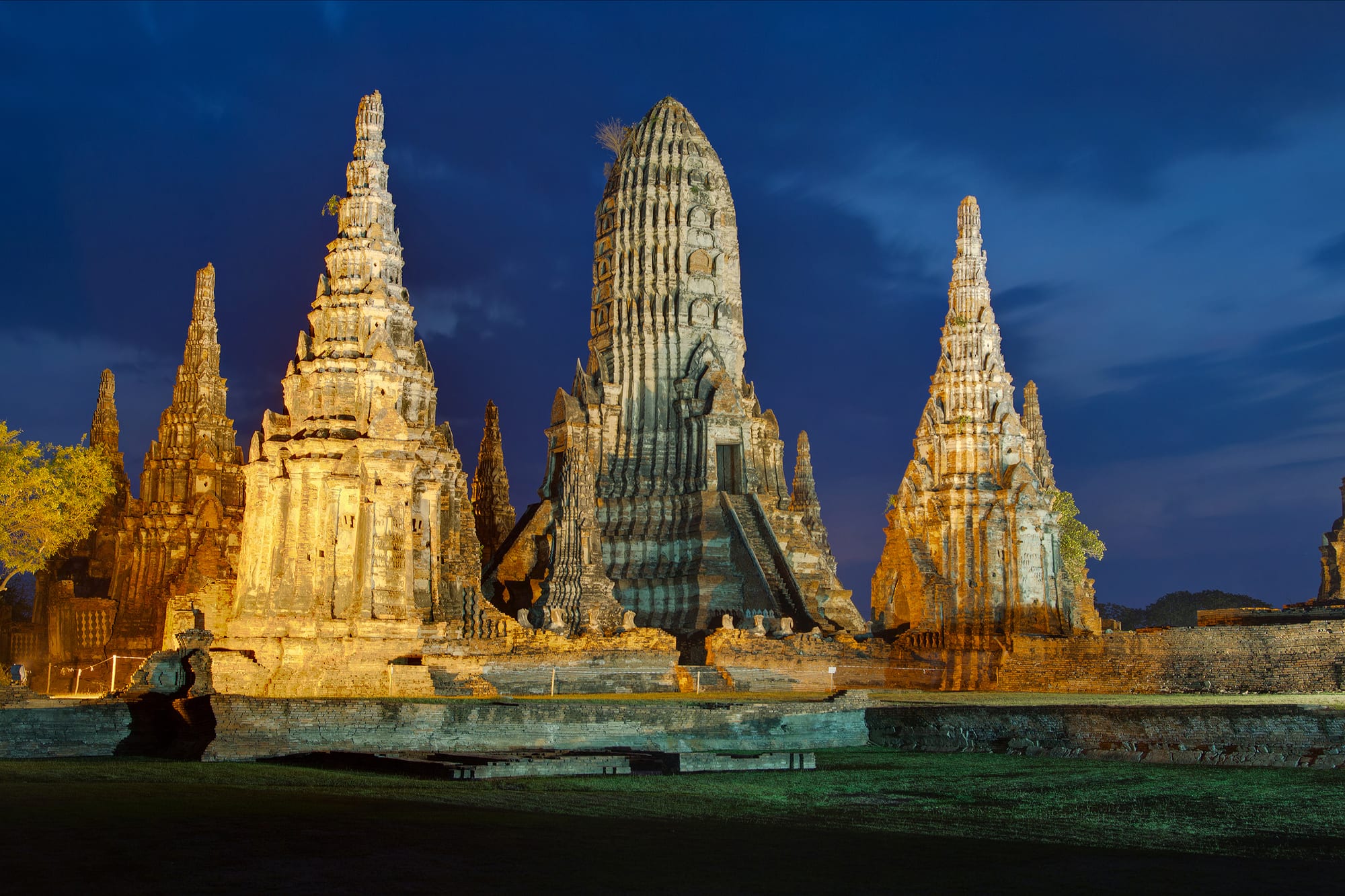
Floodlit brick prangs and chedis of Wat Chaiwatthanaram rising against a deep blue evening sky above cut grass

Bangkok & the Central Plains, Thailand

Ayutthaya

The prangs of Wat Chaiwatthanaram, on the river bank west of Ayutthaya's island, lit at dusk. (JJ Harrison / Wikimedia Commons · CC BY-SA 3.0)

The old capital of Siam, on an island where the Chao Phraya, Lopburi and Pa Sak rivers meet about 65 kilometres north of Bangkok. Founded in 1351 and destroyed in 1767, it left brick prangs, chedis and weathered Buddha images that are now a UNESCO World Heritage Site, ringed by an ordinary working provincial town.

Neighbourhoods

  • The historical park
    • First-time visitors
    • Historic district
    • Cycling

    The western half of the island, where the royal palace, Wat Phra Si Sanphet and the main ruins stand in open parkland cut by quiet roads. Little of it is residential, and the flat ground and short distances make it easy to cover by bicycle.

    Open in Maps
  • Hua Ro and the north-east island
    • Local life
    • Markets
    • Best for food

    The busy corner of the island near the confluence of the Lopburi and Pa Sak rivers, with the town's main fresh market, riverside shophouses, the Chantharakasem palace and boat piers. This is where much of everyday Ayutthaya shops and eats.

    Open in Maps
  • Naresuan Road and the town centre
    • Budget travellers
    • Close to transport
    • Nightlife

    The commercial streets between the ruins and the market, including the lane of guesthouses, tour offices and small bars long known to travellers as Soi Farang. Most of the island's accommodation, minivan stops and bicycle hire are here.

    Open in Maps
  • Across the rivers
    • Temples
    • Quiet and residential
    • Riverside

    Beyond the encircling rivers lie the temples that sat outside the old walls — Wat Chaiwatthanaram to the west, Wat Yai Chai Mongkhon and Wat Phanan Choeng to the south-east — among villages, rice fields, resorts on the bank and the railway station.

    Open in Maps

Things to do

The historical park

  • Ayutthaya Historical Parklandmark

    The protected core of the old capital, inscribed by UNESCO in 1991, covering the palace grounds and dozens of temple ruins across the island.

    Open in Maps
  • Wat Phra Si Sanphetlandmark

    The royal temple inside the palace compound and the holiest in the old capital, its three bell-shaped chedis, built in 1492 and 1529, holding the ashes of kings; they were almost the only part of the temple left standing in 1767.

    Open in Maps
  • Wihan Phra Mongkhon Bophitlandmark

    A large hall just south of Wat Phra Si Sanphet sheltering Phra Mongkhon Bophit, a seated Buddha about 13 metres high, built of brick and bronze and covered in gold leaf.

    Open in Maps
  • Wat Mahathatlandmark

    A royal monastery begun in 1374 under King Borommarachathirat I, now a field of collapsed prangs and headless Buddha images, and one of the spiritual centres of the kingdom.

    Open in Maps
  • Wat Ratchaburanalandmark

    Built in 1424 over the cremation site of two princes killed fighting for the throne; its crypt held a hoard of gold regalia found by looters in 1957.

    Open in Maps
  • Wat Phra Ramlandmark

    A tall central prang surrounded by ponds and lawns in the heart of the old city, east of Wat Phra Si Sanphet and facing east as the main Ayutthaya temples do.

    Open in Maps
  • Wat Lokayasutharamlandmark

    A reclining Buddha 37 metres long and 8 metres high lying in the open on the west of the island, draped in saffron cloth, with almost nothing left of the temple around it.

    Open in Maps

Temples across the rivers

  • Wat Chaiwatthanaramlandmark

    A riverside temple built in 1630 by King Prasat Thong on a Khmer-influenced plan, its 35-metre central prang flanked by four smaller prangs and eight chedi-shaped chapels; the most photographed ruin in the city.

    Open in Maps
  • Wat Yai Chai Mongkhonlandmark

    A working monastery south-east of the island with the tallest chedi in the city, built under King Naresuan from 1592 to mark his victory over the Burmese crown prince, and rows of seated Buddhas in saffron.

    Open in Maps
  • Wat Phanan Choenglandmark

    A riverside temple older than the city itself, holding a 19-metre seated Buddha revered by Ayutthaya's Chinese community, who keep shrines in the compound.

    Open in Maps
  • Wat Na Phra Menlandmark

    The one temple in the city left undestroyed in 1767, north of the island, with a large crowned bronze Buddha in royal dress and a green stone Dvaravati Buddha thought to be more than 1,500 years old.

    Open in Maps

Museums

  • Chao Sam Phraya National Museummuseum

    The main collection of objects excavated from the city, including the gold regalia and reliquaries recovered from the crypt of Wat Ratchaburana.

    Open in Maps
  • Wat Thammikaratlandmark

    A quiet ruin near the palace grounds with a chedi ringed by weathered stone lions and a ruined hall, still used by a small community of monks.

    Open in Maps

Short trips from the city

  • Bang Pa-In Royal Palacelandmark

    A royal summer retreat downriver on the Chao Phraya, most of it built between 1872 and 1889 for King Chulalongkorn in a mix of Thai, Chinese and European styles around lakes and lawns.

    Open in Maps
  • Wat Niwet Thammaprawatlandmark

    A Buddhist temple at Bang Pa-In completed in 1878 for King Chulalongkorn in Gothic Revival style, with stained glass and a Gothic altar, reached by a cable car from the palace across the river.

    Open in Maps

Seasonal events

  • Songkran13–15 April

    The Thai new year is marked with temple rituals, the bathing of Buddha images and several days of water-throwing in the streets.

  • Loy KrathongNovember

    Candle floats are set on the three rivers that ring the island, with the ruins lit and temple fairs through the evening.

  • Visakha BuchaMay

    The Buddhist holy day of the Buddha's birth, enlightenment and death, a public holiday kept at the town's working temples with offerings of flowers, candles and incense.

Eat and drink

Long-standing places and food districts in Ayutthaya. Hours, ratings and directions come from your maps app, always current.

Ayutthaya classics

  • River prawnsrestaurant

    Kung mae nam, giant freshwater prawns, grilled whole over charcoal and eaten with a sharp seafood dipping sauce, are the dish the town is known for; riverside restaurants specialise in them.

    Open in Maps
  • Roti sai maimarket

    Thin soft pancakes wrapped around brightly coloured strands of spun sugar, a sweet brought to the Ayutthaya kingdom by Indian Muslim traders and sold from stalls along the roads near the ruins.

    Open in Maps
  • Boat noodlesrestaurant

    Small bowls of dark, spiced noodle soup with pork or beef, a speciality of the canal country between here and Bangkok.

    Open in Maps

Markets and food streets

  • Hua Ro Marketmarket

    The town's main riverside fresh market on the north-east of the island, selling produce, grilled fish, curries and sweets from early morning.

    Open in Maps
  • Ayutthaya night marketmarket

    Evening stalls on Bang Ian Road near the ruins, with grilled meats, noodles, curries by the bag and Thai sweets.

    Open in Maps

Experience Ayutthaya

History

Ayutthaya was founded in 1351 by King U Thong, later Ramathibodi I, on an island in the floodplain where the Chao Phraya, Lopburi and Pa Sak rivers meet. The site was defensible, reachable by seagoing ships and surrounded by rice land, and the kingdom that grew from it absorbed Sukhothai and pushed west and east against Burmese and Khmer neighbours. A ring of walls, a grid of canals and a royal palace on the north bank took shape, and successive kings raised temples as merit and memorials.

By the 17th century it was one of the largest and richest cities in the world, with a population sometimes estimated at several hundred thousand and trading links to China, Japan, Persia, Portugal, the Netherlands, France and England. Foreign quarters stood outside the walls, each with its own churches, mosques or shrines, and King Narai employed the Greek adventurer Constantine Phaulkon as a senior minister before a revolution in 1688 expelled French troops.

In April 1767, after a long siege, Burmese armies took and burned the city. Temples were looted, Buddha images stripped of gold and beheaded, and the court scattered; the capital was never rebuilt here. Taksin regrouped at Thonburi and the Chakri kings built Bangkok in Ayutthaya's image instead. The ruins were quarried for brick and overgrown for a century, then surveyed and restored from the early 20th century. The historical park was inscribed by UNESCO in 1991, and in 2011 flood water entered the city and inundated the park, forcing evacuations.

Culture & Customs

Ayutthaya's identity rests on being the old capital: the city's art, court language and temple architecture set the standard that Bangkok deliberately copied, and Thai schoolchildren arrive by the coach-load to see where it happened. The Ayutthaya style — tall slim prangs derived from Khmer towers, bell-shaped chedis, crowned Buddha images in royal dress — is visible here in its home ground, and the loss of the city in 1767 remains a defining episode in the national story.

It was a cosmopolitan place, and traces remain. The Chinese community that worships at Wat Phanan Choeng has been here for centuries; there is a Portuguese settlement site with a Catholic burial ground on the south bank, a Japanese village site where Yamada Nagamasa's community traded in the 17th century, and a Dutch East India Company trading post. Descendants of Muslim merchant families live in the villages around the island.

Everyday customs are those of the central plains. Merit-making at temples structures the year, monks collect alms at dawn along the town's streets, and Loy Krathong and Songkran are the two big public occasions. Dressing in rented Thai costume to be photographed among the ruins has become popular with Thai visitors and is accepted, within the same rules of modesty that apply anywhere else.

Daily Life

Some tens of thousands of people live in the city municipality on and around the island, a number that has been falling since 2005. Life is provincial and unhurried compared with Bangkok: the market opens before dawn, schools and government offices fill the morning, and the town is quiet by mid-evening outside the guesthouse lane. Most residents live off the historical park, on the eastern side of the island and in the districts across the rivers.

The local economy has two halves. Tourism supports hotels, guesthouses, restaurants, boat and bicycle hire and a large body of guides, and it is vulnerable to any interruption in visitor numbers. Rather larger, and less visible, are the industrial estates on the mainland around the province, which assemble electronics and vehicle parts for Japanese and other manufacturers and draw workers from across Thailand and from Myanmar, Laos and Cambodia. Rice farming continues on the surrounding plain.

Water shapes everything. The rivers carry barges of sand and rice, houses on the banks stand on stilts or floating pontoons, and flooding is a recurring threat — in 2011 flood water reached the city and the historical park and broke into the industrial estates, disrupting manufacturing supply chains far beyond Thailand. Preserving the ruins while the town grows around them is a continuing tension, as is traffic on the island's narrow roads at weekends.

Food

Ayutthaya's signature is the giant freshwater prawn, kung mae nam, split and grilled over charcoal so the head fat runs into the flesh, served with a lime-and-chilli seafood sauce. Riverside restaurants around the island build their menus on it, alongside river fish such as snakehead and catfish, grilled in a salt crust or turned into sour curries. Kuay tiao reua, boat noodles in a dark broth spiced with cinnamon and star anise, are eaten in small bowls here as in the canal country to the south.

The sweet the town is known for is roti sai mai: a soft thin pancake wrapped around fine threads of spun sugar in pale pink, green and yellow, sold in plastic bags from roadside stalls and taken home as a gift. Ayutthaya also has a long association with egg-yolk sweets — foi thong, thong yot and thong yip, made with syrup and yolks — which are credited to Maria Guyomar de Pinha, of mixed Portuguese, Japanese and Bengali descent, who cooked in the court kitchens in the reign of King Narai.

Everyday eating is central Thai. Hua Ro market sells curries by the bag, grilled chicken and sticky rice, fried fish and fruit; the night stalls on Bang Ian Road do noodles and grilled meats. Chinese-Thai shophouses serve pork noodles and boiled rice soup in the morning, and coffee stands offer the strong sweet oliang, iced black coffee, and cha yen, orange tea with condensed milk.

Planning tools

Budget

Ayutthaya is noticeably cheaper than Bangkok for rooms and meals, and the town is small enough that transport costs little. The main expenses are the foreigner entry fees charged at the major ruins, which add up if every site is visited, and boat or tuk-tuk hire for the temples outside the island.

Daily Budget Midrange
USD 75–160 (riverside hotel, restaurant meals, tuk-tuk or boat hire, entry to the main temples)
Daily Budget Shoestring
USD 25–45 (guesthouse, market food, hired bicycle, third-class train)

Hiring a bicycle on the island is the cheapest way to see the ruins, and a combined ticket covers several of the main temples.

Best Time to Visit

November to February, when the plains are dry and the heat is bearable enough for cycling between ruins. March to May is punishing on open, shadeless sites. The rains from June to October green the rice fields but can flood low ground near the rivers in September and October.

Suggested Number of Days

Many visitors come from Bangkok and return the same evening. Staying overnight makes the ruins easier in the cooler hours and leaves room for the temples across the rivers and for Bang Pa-In.

First Visit
1–2 days
With Surroundings
2–3 days

Transportation

The island is flat and small, and bicycles are the usual way around it; motorbikes, tuk-tuks hired by the hour and songthaew pick-ups are the alternatives. Long-tail boats make circuits of the three rivers to the outlying temples. The railway station and several major temples are on the far bank, reached by bridge or by a short ferry crossing.

Distances between ruins are short but exposed; carry water and avoid the middle of the day on a bicycle.

Airport & Station Connections

Ayutthaya is about 65 kilometres north of Bangkok on the main northern railway. Trains take between one and two hours and stop at the station on the east bank, a short ferry ride from the island; long-distance services leave Bangkok from Krung Thep Aphiwat, while stopping trains still run from Hua Lamphong. Minivans and buses run from Bangkok's northern terminal and from Victory Monument, and river cruises come up the Chao Phraya. Suvarnabhumi Airport is about two hours away by road.

Walkability

The town centre and the market are walkable, but the historical park is spread over several square kilometres of open ground with long gaps between sites and little shade. Most visitors cycle. Pavements are intermittent and traffic on the main roads is fast.

Safety

Ayutthaya is a quiet provincial town and problems are rare. The usual risks are road traffic, particularly for visitors on hired bicycles or motorbikes, heat and sunburn on open sites, and occasional overcharging by drivers. Loose dogs gather around some of the outlying ruins.

Agree prices with tuk-tuk and boat drivers before setting off, wear a helmet on a hired motorbike, and carry water on the ruins. Check current official travel advice before travelling.

Climate

Tropical and hot all year on the flat central plain, with a short cool season, a very hot spring and a long rainy season. The open ruins hold the heat and offer little shelter.

Summer
March to May is the hottest, often 35–40°C at midday; the rainy season from June to October is a little cooler with heavy afternoon storms
Winter
November to February is dry and milder, roughly 20–33°C, with cool early mornings

Local Customs

The ruins are religious sites as well as monuments: shoulders and knees should be covered, shoes removed in halls that are still in use, and climbing on chedis or sitting with the feet pointing at a Buddha image is offensive. Posing in front of Buddha images for photographs is discouraged, and visitors should keep their own heads lower than any Buddha image they are beside.

Dress modestly at every temple, do not climb the ruins, and hire traditional Thai costume only from shops near the sites if wishing to be photographed in it.

Common Payment Methods

The currency is the Thai baht. Hotels, larger restaurants and the site ticket offices take cards or QR payment, but markets, bicycle hire, tuk-tuks and boats are cash. ATMs are on the main roads and around the market.