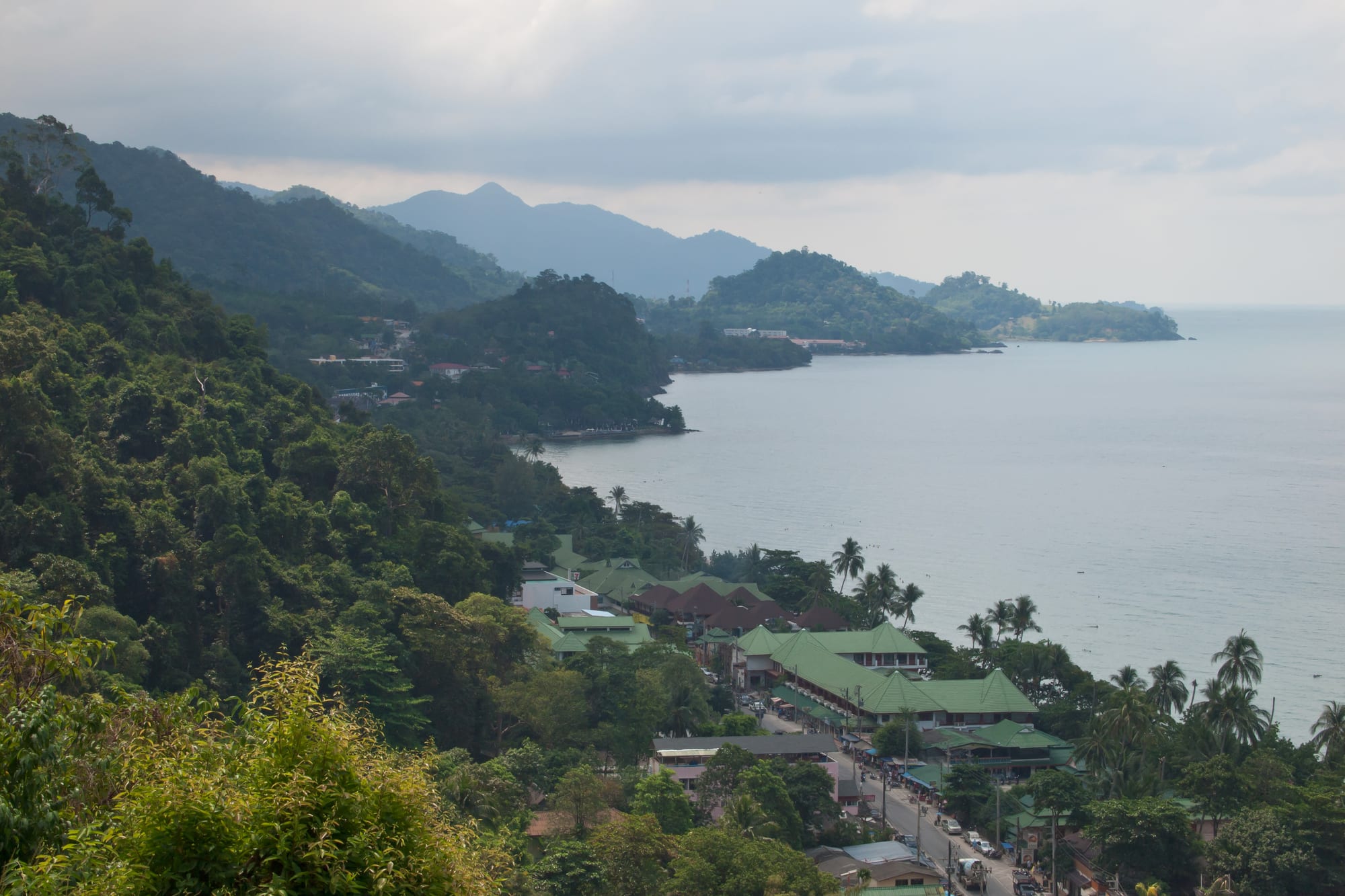
Forested hills falling to a calm sea, with the green roofs of a coastal village among palms along the shoreline below

Pattaya & the Eastern Seaboard, Thailand

Ko Chang

The west coast of Ko Chang, with forested hills behind the shoreline villages. (Vyacheslav Argenberg / Wikimedia Commons · CC BY 4.0)

Thailand's third-largest island, mountainous and forested, in Trat province close to the Cambodian border and reached by car ferry from the mainland. Most of its interior is rainforest inside a national park, its west coast is a chain of sandy bays with resorts and small villages, and its south holds fishing settlements built on stilts over the water.

Neighbourhoods

  • Hat Sai Khao (White Sand Beach)
    • First-time visitors
    • Nightlife
    • Beaches

    The longest and busiest beach on the island, nearest to the ferry piers, with a single main road of restaurants, bars, shops and dive operators behind the sand. It has the most choice and the most noise.

    Open in Maps
  • Khlong Phrao
    • Families
    • Quiet and residential
    • Beaches

    A wide beach in the middle of the west coast split by two tidal creeks, with kayaks going up the mangroves and a spread of resorts among coconut groves. Development here is lower and more scattered than further north.

    Open in Maps
  • Kai Bae
    • Beaches
    • Sunsets
    • Budget stays

    A narrower beach looking out at small offshore islets, with a mixed run of guesthouses, resorts and cheap restaurants along the road. The sand shrinks at high tide and the sunsets are the local attraction.

    Open in Maps
  • Lonely Beach and Bailan
    • Backpackers
    • Nightlife
    • Budget stays

    The southern end of the west coast, long known for cheap bungalows and late beach bars, now with smarter places mixed in. Swimming can be rough here, and the road down is steep.

    Open in Maps
  • Bang Bao
    • Best for food
    • Boat trips
    • Harbour

    A fishing village built on a long pier over the water at the south-west corner, now lined with seafood restaurants, shops and dive shops. Boats to the outer islands leave from the end of it.

    Open in Maps
  • The east coast and Salak Phet
    • Quiet and residential
    • Local life

    The far side of the island, with rubber and fruit smallholdings, mangroves, a large sheltered bay and fishing hamlets. There are few visitors and few places to stay, and the national park office at Than Mayom is here.

    Open in Maps

Things to do

Beaches

  • Hat Sai Khaobeach

    The island's main beach, a long strip of pale sand on the north-west coast backed by resorts, bars and a single road.

    Open in Maps
  • Khlong Phrao Beachbeach

    A broad central beach divided by creeks, with mangrove channels behind it that can be paddled by kayak.

    Open in Maps
  • Kai Bae Beachbeach

    A west-facing beach with rocky sections, small islands offshore and a wide view at sunset.

    Open in Maps
  • Hat Tha Nambeach

    Known to visitors as Lonely Beach, a short southern bay with strong surf in the monsoon and the island's late-night bars.

    Open in Maps

Forest, waterfalls and viewpoints

  • Mu Ko Chang National Parkpark

    A marine national park of 650 square kilometres and 52 islands, declared in 1982, which takes in about 85 per cent of Ko Chang along with the surrounding reefs, with rangers' stations and forest trails.

    Open in Maps
  • Khlong Phlu Waterfallattraction

    The island's best-known waterfall, a short walk inland from Khlong Phrao to a fall dropping into a pool deep enough to swim in.

    Open in Maps
  • Than Mayom Waterfallattraction

    A series of falls on the east coast beside a national park station, reached by a path that climbs beside the stream.

    Open in Maps
  • Kai Bae viewpointviewpoint

    A roadside terrace on the climb south of Kai Bae looking down on the west coast and the scatter of islets offshore.

    Open in Maps

Villages and the sea

  • Bang Baoneighborhood

    A stilt village strung along a pier at the south-west corner, the departure point for snorkelling and island-hopping boats.

    Open in Maps
  • Salak Kokattraction

    A mangrove bay on the south-east coast with a village-run kayaking and conservation project and a walkway through the mangroves.

    Open in Maps
  • Ko Rangattraction

    An uninhabited island in the south-west of the archipelago, inside the national park, ringed by reef and moored with buoys for dive boats; it holds the group's main snorkelling and diving sites.

    Open in Maps

Short trips from the island

  • Ko Makattraction

    A small, flat island of coconut plantations, mangrove and long sandy beaches south-east of Ko Chang, about 35 kilometres from the mainland and reached by boat from Bang Bao.

    Open in Maps
  • Ko Waiattraction

    A small island between Ko Chang and Ko Mak with coral close to shore, visited on day boats and with a few simple bungalows.

    Open in Maps
  • Tratattraction

    The mainland provincial town, with a wooden-shophouse old quarter and a covered market, about an hour away by ferry and road.

    Open in Maps

Eat and drink

Long-standing places and food districts in Ko Chang. Hours, ratings and directions come from your maps app, always current.

Island classics

  • Bang Bao seafood restaurantsneighborhood

    Open-sided places along the pier serving crab, squid, prawns and whole fish, much of it landed by the boats tied up alongside.

    Open in Maps
  • Salak Phet bay seafoodneighborhood

    A quieter cluster of restaurants over the water on the south-east coast, known among Thai visitors for crab and for fish cooked simply.

    Open in Maps

Markets and everyday food

  • Khlong Phrao and Kai Bae roadside kitchensneighborhood

    Small Thai kitchens and Isan grills along the main road, cooking curries, noodles, som tam and grilled chicken for island workers as much as visitors.

    Open in Maps
  • Trat town marketmarket

    The mainland market where much of the island's produce comes from, with cooked food, fruit and the province's famous durian and rambutan in season.

    Open in Maps

Experience Ko Chang

History

Ko Chang — the name means elephant island, taken from the shape of a headland rather than from any herd, since elephants are not native here — was settled late and lightly. Its mountains left little flat ground, and the people who came were fishermen from the mainland coast and from Hainan and southern China, joined by smallholders who planted coconut, rubber and fruit on the lower slopes. Villages formed where boats could shelter: Salak Phet in the great southern bay, Salak Kok in the mangroves, Bang Bao on its shallow inlet, each built partly on stilts over the water.

Its one turn in national history came on 17 January 1941, during the border conflict between Thailand and French Indochina, when a French naval squadron attacked Thai warships anchored off the island's southern coast. Two Thai torpedo boats were sunk and the coast-defence ship Thonburi was crippled; the engagement is commemorated at the Ko Chang Yutthanawi Memorial at Laem Ngop on the mainland opposite, and marked there each January.

The island's interior was protected as part of Mu Ko Chang National Park in 1982. Tourism arrived slowly through the 1980s and 1990s, in the form of bungalows at Hat Sai Khao and along the west coast, then much faster from the early 2000s, when the government promoted Ko Chang as a second Phuket, the pier and ferry services were improved and resorts, roads and electricity followed. The island has kept a lower-rise character than the larger southern resorts — building is limited by the park boundary and the steep ground — while the east coast has changed comparatively little.

Culture & Customs

Ko Chang's life is coastal and Buddhist, with a strong Chinese-Thai thread. Fishing families here have long roots on the mainland coast and in Hainan, and their shrines to the sea goddess and to Chinese deities stand beside the temples in the villages. Boats are blessed with coloured cloth at the bow, and the fishing calendar, not the tourist one, sets the rhythm at Salak Phet and Bang Bao.

Most of the people working in resorts, restaurants and bars have come from elsewhere: Isan and the northern provinces, and Cambodia and Myanmar. That mixture shows in the food sold along the west coast road and in the music heard at staff parties at the end of the season. The island empties noticeably in the rains, when many workers go home to help with the harvest.

Visitors are expected to observe the usual Thai courtesies — modest dress away from the sand, shoes off indoors and at temples, the wai in greeting, restraint in argument. The national park adds its own rules about reefs, wildlife and litter, and turtles, hornbills and the island's monkeys are protected. Local conservation projects, including the community kayaking scheme in the Salak Kok mangroves, have become part of the way the island presents itself, and several dive operators run reef clean-ups.

Daily Life

Ko Chang district covers the island and the smaller islands around it, and counts something over five thousand registered residents, though the working population swells well beyond that in the dry season with staff from the mainland and from neighbouring countries. Almost everyone lives on the coastal ring; the forested centre, which rises to 744 metres at Khao Salak Phet, is uninhabited.

Tourism is now the main employer by a distance, in resorts, restaurants, dive shops, songthaews and construction. Fishing continues from Bang Bao, from Salak Kok and from Ban Salak Phet, the island's oldest and largest village, supplying the island's kitchens and the mainland markets, and smallholdings of rubber, coconut and fruit work the lower slopes. Government services, the national park staff and the ferry operators make up much of the rest.

The year divides sharply. From November to April the ferries are full, the west coast is busy into the night and everyone works; from May to October the rain comes in long spells, many small businesses close, boats to the outer islands stop or reduce, and the island feels close to empty. Recurring issues are the strain on water and waste systems at the height of the season, building pressure against the park boundary, erosion of some beaches, and the dependence of nearly every household on a single trade.

Food

Seafood defines the island: blue swimmer and mud crab, squid, prawns, and fish such as grouper and snapper, cooked plainly — grilled over charcoal, steamed with lime, garlic and chilli, or fried with garlic and pepper — and eaten with nam chim seafood, the sharp chilli, garlic and lime dipping sauce. Bang Bao and Salak Phet, where the boats land, are where this is at its best, and crab is the speciality most associated with the southern bay.

The eastern mainland's dishes come across with the ferries. Trat and Chanthaburi supply flat rice noodles, the sour chamuang leaf used to braise pork in mu chamuang, fish sauce and shrimp paste, and above all fruit: durian, mangosteen, rambutan and longan from the orchards, in season from about April to June. Coconut, grown on the island and on Ko Mak, appears in curries, sweets and drinks.

Everyday eating is the food of the workers who staff the resorts. Isan grills sell gai yang chicken, som tam papaya salad and sticky rice along the west coast road; simple Thai kitchens do rice and curry, stir-fries and noodle soups; and Chinese-Thai rice porridge is a common breakfast in the villages. Beach bars sell fruit shakes, coconuts and beer over ice, and the island's coffee shops serve the sweet iced coffee drunk everywhere in Thailand.

Planning tools

Budget

Ko Chang covers a wide range, from cheap bungalows at the southern end of the west coast to large resorts at Khlong Phrao and Kai Bae. Almost everything is shipped in by ferry, so food and drink cost more than on the mainland, and transport on the island is a real expense because the distances between beaches are long and shared pick-ups charge by trip.

Daily Budget Midrange
USD 75–160 (beach resort, seafood dinners, boat trips and ferry fares)
Daily Budget Shoestring
USD 25–50 (bungalow or hostel, Thai kitchens and market food, shared songthaews)

Rooms are much cheaper from May to October, when many west-coast places cut their prices; ask a resort about transfers, since getting from the pier to a distant beach can cost as much as a night's food.

Best Time to Visit

November to April, when seas are calm, the sky is clear and the boats to the outer islands run reliably. Trat is among the wettest provinces in Thailand from May to October, and on Ko Chang that season brings heavy rain, rough crossings, slippery roads and reduced boat services, though waterfalls are at their fullest and prices at their lowest.

Suggested Number of Days

Three or four days suits one beach and the waterfalls and forest behind it. Five to seven allow the outer islands and the quieter east coast as well. Travel time from Bangkok is long enough that very short stays feel rushed.

First Visit
3–4 days
With Surroundings
5–7 days

Transportation

A single road loops most of the way around the island, steep and winding in places and unfinished on the far south-east. Shared songthaews are the public transport, running set routes along the west coast and charging by distance; they can also be hired privately. Motorbikes and small cars are rented everywhere, and boats leave Bang Bao for the outer islands.

The hills between beaches are steep and the gradients defeat underpowered scooters; inexperienced riders are better off using songthaews, and a helmet is required by law.

Airport & Station Connections

Two ferry companies run car ferries from the Ao Thammachat and Centre Point piers in the Laem Ngop area of Trat province to Ao Sapparot at the island's northern end, a short crossing. Trat town is roughly five to six hours from Bangkok by bus or car, and Trat airport, 17 kilometres from the Ao Thammachat pier, has short flights from Bangkok. Buses from Bangkok's Ekkamai terminal and minibus services connect with the ferries.

Walkability

Each beach is walkable end to end — a strip of sand and one road with restaurants and shops along it — but the island as a whole is not. The road between bays climbs over forested headlands, has little in the way of pavements and is dark at night, so people ride or take a songthaew between them. Waterfall paths are short but rocky and slippery.

Safety

The island is calm and crime is rare. Road accidents are the main danger by a wide margin: the hill roads are steep, sharp and often wet, and rented scooters injure visitors every season. Swimming is affected by currents and jellyfish at times, boats run less reliably in the monsoon, and the land border with Cambodia in Trat was affected by the 2025 border conflict, so crossings can close at short notice.

Ride with a helmet and avoid the hills at night or in rain, check the flags and local advice before swimming in the monsoon, and check the status of Cambodian border crossings before planning to use one. Check current official travel advice before travelling.

Climate

Tropical and among the wettest parts of Thailand, since the island faces the southwest monsoon directly. Rain is heavy from May to October, with the wettest months around July and August, and November to April is dry and breezy with calm seas. Temperatures vary little through the year.

Summer
hot and humid, about 28–34°C from March to May, with the rains arriving towards the end of it
Winter
dry and pleasant November–February, about 24–32°C, with light winds and clear water

Local Customs

Standards are those of the Thai coast: swimwear stays on the beach, and shoulders and knees are covered at temples and in villages. The wai is the usual greeting, feet are kept off furniture and not pointed at people, and raised voices are considered a loss of face. Fishing communities such as Bang Bao and Salak Phet are working villages rather than attractions.

Permission should be asked before photographing people at work in the fishing villages, and national park rules apply to the reefs and forest — nothing is to be collected, and coral is not to be stood on.

Common Payment Methods

The currency is the Thai baht. Resorts, dive shops and larger restaurants take cards, and Thai QR payment is widespread, but songthaews, small kitchens, beach bars and market stalls are cash businesses. ATMs are found along the west coast and charge a fee for foreign cards; cash is worth carrying before crossing to the quieter east.