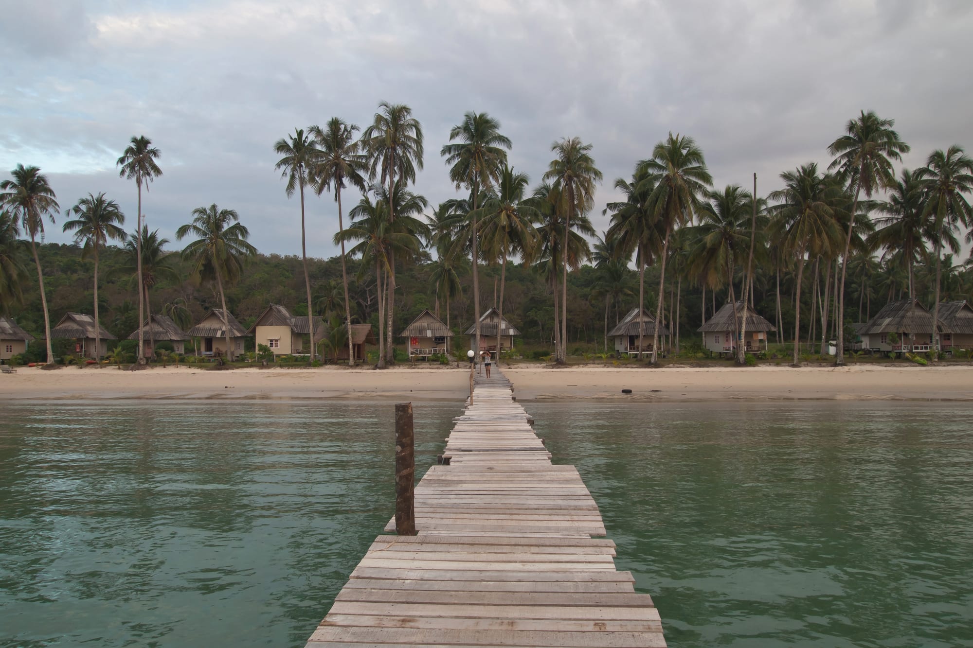
A wooden jetty leading to a sandy beach lined with tall coconut palms and low thatched bungalows under a pale sky

Pattaya & the Eastern Seaboard, Thailand

Ko Kut

The jetty and palm-backed beach at Bang Bao on the west coast of Ko Kut. (Vyacheslav Argenberg / Wikimedia Commons · CC BY 4.0)

The largest island of Ko Kut district and the second largest in Trat province, at the far eastern edge of Thai waters close to the Cambodian maritime boundary and reached by speedboat from the mainland. Much of it is forest and coconut plantation, its west coast holds a handful of quiet sand beaches and resorts, and fishing villages on stilts stand over the water on the eastern side.

Neighbourhoods

  • Khlong Chao
    • First-time visitors
    • Beaches
    • Best for food

    The island's main strip, a long west-coast beach with a tidal creek behind it, most of the resorts and restaurants, a few shops and the path to the best-known waterfall. It is as close as Ko Kut comes to a centre.

    Open in Maps
  • Ao Phrao and Ao Ngamkho
    • Quiet and residential
    • Beaches
    • Sunsets

    Small bays north and south of Khlong Chao, with scattered bungalows, rocky sections between stretches of sand and very little noise after dark.

    Open in Maps
  • Bang Bao
    • Beaches
    • Families

    A sheltered bay on the south-west coast with clear shallow water, a jetty and a line of palms behind the sand. Resorts here are spread out and the beach is one of the island's calmest.

    Open in Maps
  • Ao Salat
    • Local life
    • Best for food
    • Harbour

    A fishing village of wooden houses on stilts over the water at the north-eastern corner, with a pier, seafood restaurants and boats working the surrounding waters. Few visitors stay, but many come to eat.

    Open in Maps
  • Ao Yai
    • Local life
    • Quiet and residential

    A second stilt village on the eastern side, older and quieter than Ao Salat, reached by a long road across the island and looking out towards the mainland and the Cambodian coast.

    Open in Maps

Things to do

Beaches and bays

  • Khlong Chao Beachbeach

    A wide sweep of pale sand on the west coast with calm water and a creek that can be paddled inland by kayak.

    Open in Maps
  • Bang Bao Beachbeach

    A curved southern bay of shallow clear water backed by coconut palms, reached from the west coast road.

    Open in Maps
  • Ao Phraobeach

    A quiet stretch of sand and rock south of Khlong Chao, with a few resorts and little else.

    Open in Maps
  • Ao Tapaobeach

    A small bay towards the north of the west coast, shaded by trees and used as a boat landing as well as a beach.

    Open in Maps

Waterfalls and the forest

  • Khlong Chao Waterfallattraction

    The island's best-known fall, a short walk or kayak trip inland from Khlong Chao, dropping into a wide pool deep enough to swim in.

    Open in Maps
  • Khlong Yai Ki Waterfallattraction

    A smaller fall a little further north, with a rock pool below it and a short forest path from the road.

    Open in Maps
  • The Makha treeattraction

    A very large old tree in the forest inland of Khlong Chao, reached by a short walk and treated as a landmark by islanders.

    Open in Maps

Villages and the sea

  • Ao Salatneighborhood

    A working fishing village of stilt houses and walkways at the north-east corner, where the day's catch is landed and cooked in the restaurants along the pier.

    Open in Maps
  • Ao Yaineighborhood

    An older stilt settlement on the east coast, quiet and largely unchanged, with a small temple and views across to the mainland.

    Open in Maps
  • Wat Yai Ko Kutlandmark

    An island temple near Ao Yai, with an old wooden ordination hall and a bell tower among the coconut groves.

    Open in Maps

Short trips from the island

  • Ko Makattraction

    The third largest island in Trat province, low and flat, with coconut plantations and quiet beaches, lying between Ko Kut and Ko Chang about half an hour away by speedboat.

    Open in Maps
  • Tratattraction

    The mainland provincial town, with a wooden-shophouse old quarter and a covered market, reached from the island's piers by boat and road.

    Open in Maps

Eat and drink

Long-standing places and food districts in Ko Kut. Hours, ratings and directions come from your maps app, always current.

Island classics

  • Ao Salat seafood restaurantsneighborhood

    Places built out over the water at the fishing pier, serving crab, squid, prawns and whole fish landed by the boats moored below.

    Open in Maps
  • Khlong Chao restaurantsneighborhood

    Small Thai kitchens and resort restaurants along the island's busiest beach, cooking curries, stir-fries, grilled seafood and som tam.

    Open in Maps

Everyday food

  • The west coast road kitchensneighborhood

    Roadside shops and stalls where island workers eat rice and curry, noodle soups and grilled chicken, well away from the beachfront prices.

    Open in Maps
  • Trat town marketmarket

    The mainland market that supplies much of the island, with fruit from the eastern orchards, dried seafood and cooked food to take on the boat.

    Open in Maps

Experience Ko Kut

History

Ko Kut sits at the far eastern edge of Thai waters, and its history belongs as much to the Gulf's boat routes as to the mainland. The island was settled slowly, by fishing families from the Trat coast and by Khmer-speaking people from the Cambodian coast a short distance across the water, who cleared land for coconut, rubber and fruit and built villages on stilts where the water was sheltered enough for boats.

The frontier moved around them. After the Paknam crisis of 1893 France pressed its claims against Siam along this coast, occupying Chanthaburi from 1893 until 1905 and then holding Trat and its islands until the treaty of 1907, under which France withdrew from Trat while Siam ceded Battambang, Siem Reap and Sisophon. The memory of that exchange is still marked in Trat province. Ko Kut itself was disputed between Thailand and Cambodia in the mid-1960s, and the 1907 treaty remains the recognised legal basis for its status as Thai territory, though the sea boundary nearby is still claimed by both countries.

For most of the 20th century the island lived from coconut, fishing and rubber, with no electricity grid, no through road and a population counted in thousands. Visitors arrived much later than on Ko Chang: a few bungalows in the 1990s, then resorts along the west coast from the 2000s, together with a road, piers and a supply of power. Development has stayed comparatively low-key — there is no nightlife strip and no town — and the island is marketed on quietness, which has in turn attracted higher-priced resorts.

Culture & Customs

Ko Kut's culture is coastal, Buddhist and mixed. Thai and Khmer-speaking families have lived alongside each other here for generations, and many households have relatives on both sides of the water; the temple at Ao Yai and the small shrines in the villages serve them together. Chinese-Thai traders have long handled the coconut and fish trade, and their shrines stand near the piers.

Fishing sets the pattern of the year in the eastern villages: boats go out according to season and weather, nets and traps are repaired on the walkways between the stilt houses, and squid is dried on racks in the sun. Coconut has been the other constant, and groves cover much of the flatter ground, their crop pressed for oil, dried for copra and sold fresh to the resorts.

Visitors are few enough that ordinary courtesies matter a great deal. Villages are lived in rather than displayed, and photographing homes, boats or people at work is a request rather than a right. Swimwear stays on the beach; shoulders and knees are covered at the temple; voices are kept low. The island has no large festival of its own, and the calendar follows the national one, with Songkran in April and Loi Krathong in November marked quietly at the temple and on the beaches.

Daily Life

Ko Kut district takes in the island and about a dozen smaller ones around it, and had some 2,900 registered residents at the 2011 count, making it the least populous district in Thailand. Most live in the eastern villages of Ao Salat and Ao Yai and in small settlements along the west coast road, with the school, the health centre and the district office serving the whole island.

The economy rests on three things: fishing, coconut and rubber smallholdings, and tourism, which has become the largest employer along the west coast. Resort staff come from the mainland, from Isan and from across the border, and much of the island's food, fuel, building material and fresh water logistics arrive by boat from Trat. Government services, boat operators and construction make up most of the rest.

Life is quiet and early. Boats leave before dawn and the villages are busiest in the morning when the catch comes in; the middle of the day is still; the evening ends early by Thai resort standards, and outside the high season much of the island closes. The recurring concerns are the reliability of electricity and water, waste disposal, the cost and availability of boats in the monsoon, the distance to hospitals on the mainland, and the balance between new resort building and the plantations and forest that give the island its character.

Food

Seafood is the island's own cooking, and the stilt villages are where it is best: crab from the surrounding waters, squid grilled or fried with garlic and pepper, prawns, and whole fish steamed with lime, chilli and garlic or grilled over charcoal, all served with nam chim seafood, the sour-hot dipping sauce. Dried and salted squid hangs on racks at Ao Salat, and shrimp paste and fish sauce from the Trat coast flavour much of what is cooked.

Coconut runs through the island's food, as it does through its farming. It goes into curries — the eastern coast leans towards rich southern-style coconut curries as well as central Thai ones — into sweets, and into drinks taken straight from the nut. The mainland supplies the eastern provinces' specialities: flat rice noodles from Chanthaburi, mu chamuang, pork braised with the sour chamuang leaf, and the orchard fruit of Trat and Chanthaburi, durian, mangosteen, rambutan and longan, in season in the middle of the year.

Everyday food is the same as anywhere in working Thailand, cooked for islanders and resort staff: rice with curries from the tray, stir-fried basil with pork and a fried egg, noodle soups, and Isan grills selling gai yang, som tam and sticky rice. Resorts serve Thai and Western menus, fruit shakes and coffee, and the beach bars are small, few and close early.

Planning tools

Budget

Ko Kut is not a budget island. Supplies come by boat, resorts are spread along the west coast with few cheap rooms between them, and transfers by speedboat add a fixed cost to any stay. Eating at village restaurants and roadside kitchens rather than at resorts is the main way to keep costs down, and low-season rates are much lower.

Daily Budget Midrange
USD 75–160 (beach resort, seafood dinners, speedboat transfers and island transport)
Daily Budget Shoestring
USD 35–60 (simple bungalow, village and roadside kitchens, shared transfers)

Fix a price for island transport at the pier, since distances between bays are long, and check whether a resort includes transfers before booking.

Best Time to Visit

November to April, when the sea is calm, the crossings reliable and the skies clear. Trat is among the wettest provinces in Thailand, and from May to October the island sees heavy rain and rough water; boats run less often, some resorts and restaurants close for part of the season, and the waterfalls are at their fullest.

Suggested Number of Days

Three or four days suits an island where the point is slowness. Five or six allow a neighbouring island or the mainland town as well. The journey from Bangkok is long, so very short stays spend much of their time in transit.

First Visit
3–4 days
With Surroundings
5–6 days

Transportation

One road runs the length of the west coast and across to the eastern villages, narrow, hilly and part unsurfaced. There is no public transport: resorts arrange pick-ups, taxis are shared pick-up trucks arranged by phone, and many visitors rent a motorbike or bicycle. Boats link the island's piers with the mainland and the neighbouring islands.

Distances between bays are longer than they look and the hills are steep, so arranging transport in advance matters more here than on busier islands; a helmet is required by law on a motorbike.

Airport & Station Connections

Speedboats run from the Laem Sok pier south of Trat town to the island's west-coast piers, taking roughly an hour to an hour and a half depending on the boat and the sea, with a slower car ferry as well. Trat town is about five to six hours from Bangkok by bus or car, and Trat airport, run by Bangkok Airways, has daily flights from Suvarnabhumi.

Walkability

Each beach can be walked end to end, and the waterfall paths inland from Khlong Chao are short. The island as a whole is not walkable: it is long from north to south, the road is hilly and unlit, and there are stretches of forest and plantation with nothing on them, so a bicycle or motorbike is the practical way to move between bays.

Safety

Ko Kut is quiet and crime is very rare. The risks are practical: motorbike falls on steep and unsurfaced roads, slippery rocks at the waterfalls, strong currents and rough crossings in the monsoon, and the distance from full medical care, which is on the mainland. Fighting on the Cambodia–Thailand border reached Trat province in July 2025; a ceasefire agreed in December 2025 has held, but border crossings have been closed or restricted at short notice.

Ride slowly on the hills and after rain, take care on wet rock at the falls, carry any needed medicines, and check the status of Cambodian border crossings before planning to use one. Check current official travel advice before travelling.

Climate

Tropical and very wet in season, as the island faces the southwest monsoon directly. Rain is heavy from May to October, heaviest around July and August, and November to April is dry and breezy with calm seas. Temperatures change little through the year.

Summer
hot and humid, about 28–34°C from March to May, with the rains arriving at the end of it
Winter
dry and comfortable November–February, about 24–32°C, with light winds and clear water

Local Customs

Island manners are those of coastal Thailand, and the stilt villages are homes and workplaces rather than attractions. Swimwear stays on the beach, shoes come off indoors and at the temple, shoulders and knees are covered when visiting either, and the wai is the usual greeting. Many residents have family links across the water in Cambodia, and Khmer as well as Thai is heard.

Permission should be asked before photographing houses, boats or people at work in the fishing villages, and rubbish is best carried back out, since waste disposal on the island is limited.

Common Payment Methods

The currency is the Thai baht. Resorts take cards and Thai QR payment is used in many shops, but village restaurants, transport and small stalls want cash, and ATMs on the island are few and can run out at busy times. It is worth bringing enough cash from Trat for the whole stay.