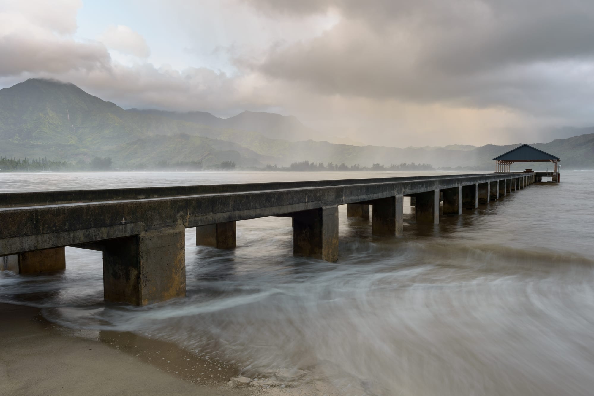
A long concrete pier with a roofed end runs out into Hanalei Bay, with misty green mountains behind

Hawaii, United States

Hanalei

Hanalei Pier, built out into Hanalei Bay on the north shore of Kauaʻi. (Jawed Karim / Wikimedia Commons · CC BY-SA 3.0)

A small village at the mouth of the Hanalei River on the north shore of Kauaʻi, set at the midpoint of the island's largest north-shore bay. Taro, then rice, made it; the flooded taro fields of its valley still supply much of Hawaii's crop, and today it is the last town on the road to Hāʻena and the Nā Pali coast.

Neighbourhoods

  • Hanalei town
    • First-time visitors
    • Best for food
    • Historic district

    The village strung along the Kuhio Highway between the river and the Waiʻoli mission, with its shops, restaurants, the old mission church and the farmers' market. Many descendants of the Chinese, Japanese, Filipino and Portuguese families who once farmed rice on the plain still live here.

    Open in Maps
  • Hanalei Bay beachfront
    • Beaches
    • Surfing
    • Quiet and residential

    Nearly two miles of beach curving around the bay below the mountains, backed by streets of houses and holiday rentals. The pier stands near the river mouth at the eastern end; calm summer water suits paddleboards and swimming, while winter brings big surf.

    Open in Maps
  • Princeville
    • Resorts and condos
    • Views

    A master-planned community of homes and condos across the river, overlooking the bay, sold for development as a golf course and resort in 1968. It began as a 19th-century plantation named after Prince Albert Kamehameha, and the lookout over the taro fields of the Hanalei Valley is on its edge.

    Open in Maps
  • Wainiha and Hāʻena
    • Beaches
    • Hiking
    • Quiet and residential

    The thinly settled shore west of town, where the road narrows over a series of one-lane bridges towards Hāʻena State Park and the start of the Kalalau Trail. Landslides in the 2018 floods left Wainiha and Hāʻena without road access.

    Open in Maps

Things to do

The bay and the beaches

  • Hanalei Baybeach

    The largest bay on the north shore, nearly two miles of sand ringed by mountains, chosen as the top beach in Dr. Beach Stephen Leatherman's 2009 list.

    Open in Maps
  • Hanalei Pierlandmark

    A concrete pier with a covered end, lengthened in 1912 to ship the valley's rice and abandoned for shipping in 1933, now a gathering place for fishing, picnics and swimming.

    Open in Maps
  • Lumahaʻi Beachbeach

    A long beach at the mouth of the Lumahaʻi River set against vertical cliffs, seen in the 1958 film South Pacific; rip currents make it unsafe for swimming most of the year.

    Open in Maps

The valley and its history

  • Waiʻoli Mission Districtmuseum

    The mission founded by American missionaries who settled here in 1834, with their church of 1841, now the Mission Hall, a church of 1912 and the Waiʻoli Mission House, now a museum open to the public.

    Open in Maps
  • Hanalei National Wildlife Refugepark

    A river valley of taro fields and wetlands set aside in 1972 for endangered waterbirds such as the Hawaiian stilt and nēnē; the wetlands are closed to the public, but interpretive panels stand at the Hanalei Valley overlook.

    Open in Maps
  • Hanalei Riverpark

    The second-largest river in the state by flow, designated an American Heritage River in 1998, crossed at the edge of town by a one-lane truss bridge rebuilt as a replica of the 1912 original.

    Open in Maps

Hāʻena and the Nā Pali coast

  • Hāʻena State Parkpark

    The 'end of the road' five miles west of Hanalei, with Kēʻē Beach's reef lagoon, ancient sea caves and hula sites including a heiau dedicated to Laka; entry needs a parking reservation and fee, with a daily limit of 900 people.

    Open in Maps
  • Limahuli Garden and Preservepark

    A botanical garden of the National Tropical Botanical Garden in a valley below Makana, with native and Polynesian-introduced plants and ancient taro terraces.

    Open in Maps
  • Kalalau Trailtrail

    An 11-mile footpath from Kēʻē Beach to the Kalalau Valley; the first two miles to Hanakāpīʻai stream need a park entry reservation, and going beyond requires a camping permit.

    Open in Maps
  • Nā Pali Coast State Parkpark

    The roadless coast of cliffs rising up to 4,000 feet above the sea, reached on foot by the Kalalau Trail, by kayak, or by charter boats from Hanalei Bay and Port Allen.

    Open in Maps

Eat and drink

Long-standing places and food districts in Hanalei. Hours, ratings and directions come from your maps app, always current.

Hanalei classics

  • Hanalei Farmers Marketmarket

    A market in the centre of town, near the church, selling produce from the valley and the north shore.

    Open in Maps
  • Waipā Farmers Marketmarket

    A second farmers' market just outside the village, selling produce from north-shore farms.

    Open in Maps
  • Shave ice in Hanaleicafe

    Finely shaved ice soaked in flavoured syrups, a cool-down after the beach.

    Open in Maps

Food districts

  • Restaurants in Hanalei townneighborhood

    Restaurants and food trucks along the Kuhio Highway through the village, including a truck selling taro doughnuts.

    Open in Maps

Experience Hanalei

History

Hanalei was densely populated long before Europeans arrived. Its people grew taro, bananas, breadfruit, sweet potatoes, yams and coconuts on the river plain and fished the bay; the name is usually translated as "crescent bay" or "lei making". In 1817 two short-lived Russian forts near Hanalei were briefly part of tsarist Russian America, after Kauaʻi's chief Kaumualiʻi, in dealings with the Russian-American Company's agent Georg Anton Schäffer, signed a "treaty" granting Tsar Alexander I a protectorate over the island. In 1824 Kamehameha II's royal yacht, the Pride of Hawaii, struck a reef and sank near the mouth of the Waiʻoli River; its remains were excavated by Smithsonian archaeologists between 1995 and 2000. American missionaries settled at Waiʻoli in 1834, and their church of 1841 still stands as the Mission Hall.

Hawaiian royalty visited often in the 19th century; a visit by Prince Albert Kamehameha, son of Kamehameha IV and Queen Emma, gave the neighbouring plantation of Princeville its name. From the 1860s Chinese workers whose plantation contracts had ended turned the wetlands over to rice, which was shipped to Honolulu and became the islands' second-largest export crop. Japanese, Filipino and Portuguese farmers followed, and the community built rice mills, schools, stores, churches and temples. After annexation in 1898 Hawaiian rice could not compete with California's, and the pier, lengthened for the trade in 1912, was abandoned for shipping in 1933.

Today taro farms fill much of the lower valley, part of which became a national wildlife refuge in 1972. Hurricane Iniki badly damaged the pier in 1992. In April 2018 a gauge just west of the village recorded 49.69 inches of rain in 24 hours, the greatest total on record in the United States; landslides and floods cut the highway, leaving the Kuhio Highway closed as of November 2018, and Hāʻena State Park reopened only after a long closure.

Culture & Customs

Hanalei's look and pace are bound up with farming and the sea. The valley floor is a patchwork of flooded taro fields worked by families, many of them descended from the Chinese, Japanese, Filipino and Portuguese rice farmers of the early 20th century, and the pier at the river mouth has long been where families fish, picnic and swim. In summer the bay fills with paddleboards and moored sailboats; in winter it becomes one of the island's favourite surfing spots.

The village has an outsized place in popular culture. Scenes of South Pacific, released in 1958, were filmed in town and at Lumahaʻi Beach, and the bay and nearby Princeville appear in The Descendants of 2011. Haruki Murakami set a short story, "Hanalei Bay", here. A long-circulating reading of "Puff, the Magic Dragon" places Puff's homeland of "Hanah Lee" in Hanalei, an interpretation the song's authors have rejected.

Older Hawaiian traditions are rooted along the coast to the west. At Hāʻena, archaeological sites tied to the hula, including a heiau dedicated to Laka, sit above the beaches, and the Nā Pali coast beyond was settled by Polynesian voyagers and served as a link in trade between Hanalei, Waimea and Niʻihau. The Waiʻoli Mission District, listed on the National Register of Historic Places in 1973, keeps the missionary chapter of the story, and the Kuhio Highway itself, with its one-lane bridges, is on the register too.

Daily Life

Hanalei is a census-designated place with a population of 444 at the 2020 census; Princeville, across the river, had 2,157. Holiday rentals, restaurants, surf and paddleboard hire, kayak outfitters and the boat charters that leave from the bay for the Nā Pali coast provide much of the work, alongside taro farming: about 60 per cent of Hawaii's taro is grown in the area around the lower river.

Hanalei Elementary School serves the village's younger children, while older students travel to middle and high school in Kapaʻa on the east coast. Everything arrives along the single highway and its one-lane bridges, so traffic, visitor numbers and parking are the everyday local issues; Hāʻena State Park now needs a parking reservation, with a daily limit of 900 people, under an agreement with a local nonprofit negotiated during its long closure after the 2018 floods.

The floods remain a reference point. Water stood eight feet deep near Hanalei, power failed in Hanalei and Wainiha, the post office reopened only at the end of July 2018, and Hurricane Lane brought further flooding to the same area that August. Reconstruction of the highway was estimated at about $100 million.

Food

Taro is the crop that defines Hanalei, and the valley's flooded fields produce much of Hawaii's supply. Its root is pounded into poi, the traditional Hawaiian staple, and its leaves wrap laulau, parcels of pork, beef or chicken with salted butterfish; newer uses include taro doughnuts sold from a food truck in the village. The plate lunch — rice, macaroni salad and a main such as kalua pork or teriyaki — and poke, cubes of raw fish dressed with soy, sesame or seaweed, are everyday food here as across the islands.

Much of the produce comes from farms on the north shore itself, sold at the Hanalei Farmers Market near the church in town and at the Waipā Farmers Market just outside it. Shave ice, finely shaved ice drenched in flavoured syrups, is the classic way to cool down after the beach. Restaurants and food trucks line the highway through the village.

Planning tools

Budget

The north shore is among the dearer corners of an expensive state. Most beds are holiday rentals and condos in Hanalei and Princeville rather than hotels, food costs more because so much is shipped in, and boat trips, kayak tours and the Hāʻena parking fee add up. The beaches, the pier and the valley overlook are free.

Daily Budget Midrange
USD 320–600 (condo or holiday rental, restaurant meals, rental car, a boat or kayak trip)
Daily Budget Shoestring
USD 130–220 (budget room, farmers-market food and plate lunches, free beaches and walks)

Rent a place with a kitchen and use the farmers' markets, and book the Hāʻena parking reservation before arriving on the north shore.

Best Time to Visit

Hanalei can be visited all year. Summer has the calmest water in the bay for swimming, paddleboarding and mooring, and is the season for boat and kayak trips along the Nā Pali coast. Winter brings big surf, which makes the bay a favourite surfing spot, and more rain.

Suggested Number of Days

Two or three days cover the village, the bay and the road west. Allow four to six to include a longer hike, a boat trip or the rest of Kauaʻi, and more if the weather turns, as heavy rain can close trails and roads on the north shore.

First Visit
2–3 days
With Surroundings
4–6 days

Transportation

A rental car is the practical way to reach Hanalei and the beaches beyond it. The Kuhio Highway is the only road: west of Princeville it becomes the narrow ten-mile Route 560 to Hāʻena, with 11 one-lane bridges, the first five built in 1912 and some still of wood. With no alternative route, traffic backs up easily. Parking at Hāʻena State Park must be reserved in advance.

Yield at the one-lane bridges; local custom is to let the larger queue cross first, or to give way after five to seven cars have passed.

Airport & Station Connections

Lihue Airport on the island's east coast is the gateway, with flights from Honolulu and the mainland. From there the Kuhio Highway runs north through Kapaʻa, Kilauea and Princeville to Hanalei; Hāʻena, five miles beyond the village, is a little over an hour's drive from Lihue.

Walkability

The village itself is small and easy on foot, and the beach road, the pier and the shops along the highway are within a short walk of each other. Beyond town the highway is narrow, with little room for walkers on the bridges, so the beaches to the west need a car or shuttle.

Safety

For most visitors the US is safe, with the main risks being petty theft and car break-ins in tourist areas of some cities, road accidents over long distances, extreme weather, and the hazards of the outdoors. On the north shore the ocean is the main danger: winter surf is large, Lumahaʻi Beach is unsafe for swimming most of the year, and very strong currents run beyond the reef at Kēʻē. Heavy rain can bring sudden flooding, as in April 2018, when water reached eight feet deep near Hanalei.

Swim in calm summer conditions and at lifeguarded spots, stay out of streams and off the Kalalau Trail after heavy rain, and leave nothing in parked cars at beaches and trailheads. Check current official travel advice before travelling.

Climate

Wet, green and warm all year. In the Hanalei valley the average annual temperature is about 73°F, and rainfall usually exceeds 75 inches a year. The figures below are for Hawaii's coasts as a whole.

Summer
79–88°F at sea level across Hawaii, drier, with steady trade winds and calmer seas on north shores
Winter
72–81°F at sea level across Hawaii, more showers and big waves on north shores

Local Customs

Tipping of roughly 18–22 per cent in restaurants is expected, as across the country. Life is casual and unhurried. The taro fields are working farms and the refuge wetlands are closed to the public, so they are seen from the overlook and the roadside. Ancient sites at Hāʻena, including the heiau dedicated to Laka, the goddess of hula, are sacred.

Stay out of the taro fields, leave stones and offerings at heiau untouched, and let the larger line of traffic cross first at the one-lane bridges.

Common Payment Methods

The currency is the US dollar. Cards and mobile payment are accepted almost everywhere, and some places no longer take cash; farmers'-market stalls and food trucks are the places where small bills are most useful.