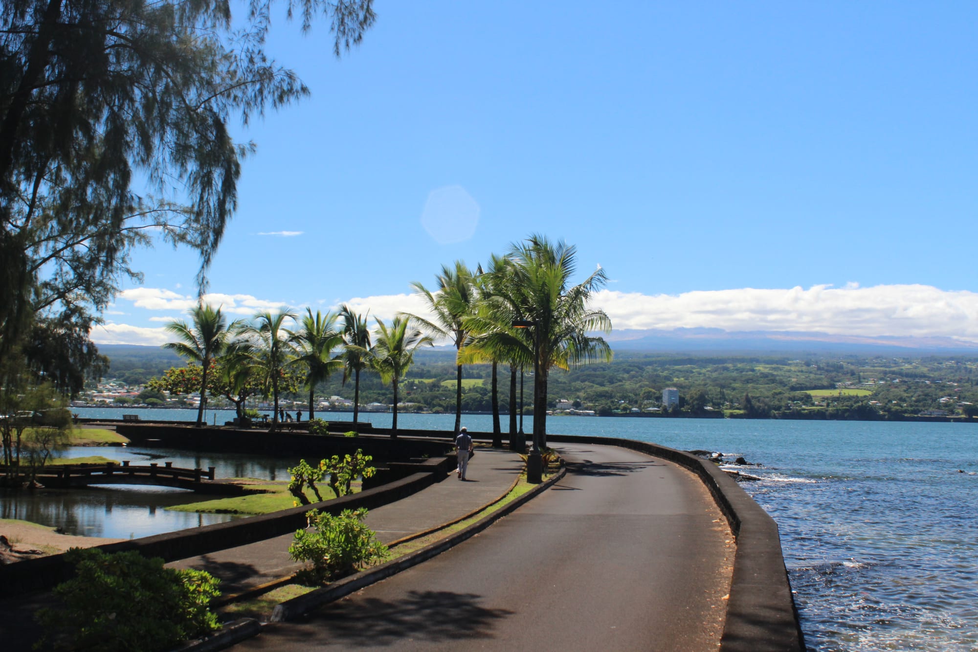
A curving seawall path lined with palm trees beside Hilo Bay, with the town and a long mountain slope behind

Hawaii, United States

Hilo

Hilo Bay seen from Liliʻuokalani Park and Gardens on the Waiākea Peninsula. (AlaskaDave / Wikimedia Commons · CC BY-SA 3.0)

The county seat and largest town of the Island of Hawaiʻi, on the funnel-shaped Hilo Bay of the rainy windward coast, with Mauna Kea and Mauna Loa rising behind. Sugar built it, two tsunamis destroyed its bayfront, and today it is a university and astronomy town, home of the Merrie Monarch hula festival and a common base for visiting Hawaiʻi Volcanoes National Park.

Neighbourhoods

  • Downtown and the Bayfront
    • First-time visitors
    • Best for food
    • Historic district

    The old commercial centre between the Wailuku River and Kamehameha Avenue, facing the bay across a strip of parkland. Shops, galleries and restaurants fill its older buildings, along with the Pacific Tsunami Museum, the Palace Theater and the farmers' market; parking is hard to find at midday.

    Open in Maps
  • Banyan Drive and the Waiākea Peninsula
    • Hotels
    • Parks and gardens
    • Waterfront

    The loop road on the peninsula south-east of downtown where most of the town's hotels stand, beside Liliʻuokalani Park and Gardens and the fish market area. Downtown is about a mile away along the bay, and the shopping centres lie south along Highway 11.

    Open in Maps
  • Upper Hilo and the university
    • Students
    • Waterfalls
    • Quiet and residential

    The residential town climbing inland from the bay towards Waiākea-Uka on the flanks of the volcanoes. Waiānuenue Avenue leads up to Rainbow Falls, Route 200 passes the University of Hawaiʻi at Hilo and ʻImiloa on its way to Kaumana Cave, and rain increases with altitude.

    Open in Maps
  • The eastern shore
    • Beaches
    • Snorkelling
    • Local life

    East of the harbour, Kalanianaʻole Avenue follows the shore past small beach parks and swimming spots to Richardson Ocean Park at its end — the nearest thing Hilo has to a beach district.

    Open in Maps

Things to do

Museums and history

  • Pacific Tsunami Museummuseum

    A downtown museum, opened in 1998, devoted to the 1946 and 1960 tsunamis that devastated much of the island's east coast, especially Hilo.

    Open in Maps
  • Lyman Museummuseum

    A natural history museum founded in 1931 beside the Lyman family's mission house of 1838, the oldest surviving wood-framed building on the island, which is open for tours.

    Open in Maps
  • ʻImiloa Astronomy Centermuseum

    A centre at the University of Hawaiʻi at Hilo with a planetarium and bilingual Hawaiian–English exhibits linking the Mauna Kea observatories with Polynesian voyaging by the stars.

    Open in Maps
  • Palace Theaterattraction

    A Beaux-Arts cinema of 1925 downtown, reopened in 1998 as an arthouse venue for films, concerts and theatre.

    Open in Maps

Parks and the bay

  • Liliʻuokalani Park and Gardenspark

    Edo-style Japanese gardens of 1917–1919 on land given by Queen Liliʻuokalani, with ponds, bridges, pagodas, torii and a Japanese teahouse; the footbridge to Coconut Island offshore collapsed in November 2025.

    Open in Maps
  • Wailoa River State Recreation Areapark

    A park laid out as a buffer zone after the 1960 tsunami wiped out the central bayfront, with a statue of King Kamehameha erected in 1997.

    Open in Maps
  • Hilo Bayviewpoint

    The broad bay that gives the town its setting, sheltered by a breakwater completed in 1929, with views from the bayfront towards Mauna Kea and Mauna Loa.

    Open in Maps
  • Richardson Ocean Parkbeach

    A county park just east of town on a former estate, the only beach in the Hilo area with black and green sand, with a swimming cove, fishponds and coconut grove.

    Open in Maps
  • Panaʻewa Rainforest Zooattraction

    A small county zoo and the only zoo in the United States set in a rainforest, with more than 80 species of animals.

    Open in Maps

Waterfalls and lava

  • Rainbow Fallspark

    Waiānuenue, an 80-foot fall on the Wailuku River in Wailuku River State Park, named for the rainbows seen in its mist on sunny mornings, with a large banyan beside the path.

    Open in Maps
  • Kaumana Caveattraction

    A lava tube more than two miles long formed by an 1881 flow from Mauna Loa, entered through a collapsed skylight off Route 200 inland from the town.

    Open in Maps

Markets

  • Hilo Farmers Marketmarket

    The downtown market at Mamo Street and Kamehameha Avenue, selling produce, fresh fish, cut flowers such as anthuriums and protea, Hawaiian-style jams and crafts.

    Open in Maps

Short trips from the town

  • ʻAkaka Falls State Parkpark

    About 11 miles north, a loop trail through rainforest to viewpoints over the 442-foot ʻAkaka Falls and the 300-foot Kahūnā Falls.

    Open in Maps
  • Hawaiʻi Volcanoes National Parkpark

    A UNESCO World Heritage Site around Kīlauea and Mauna Loa; Kīlauea's Halemaʻumaʻu crater has erupted intermittently since December 2020, and as of 2026 some road segments and trails remain closed.

    Open in Maps

Seasonal events

  • Merrie Monarch FestivalThe week beginning on Easter Sunday (March or April)

    A week-long festival honouring King David Kalākaua, ending with three nights of ancient and modern hula competition that are considered the most prestigious in the world.

Eat and drink

Long-standing places and food districts in Hilo. Hours, ratings and directions come from your maps app, always current.

Hilo classics

  • Café 100restaurant

    A local diner destroyed twice by tsunamis and rebuilt, known for loco moco — rice topped with a hamburger patty, fried egg and gravy, the dish created in Hilo.

    Open in Maps
  • Suisanmarket

    A fish market near the Japanese gardens selling many kinds of poke by weight, often taken to the park across the street for a picnic.

    Open in Maps
  • Big Island Candiescafe

    A Hilo sweet maker known for its chocolate hand-dipped cookies and confections.

    Open in Maps

Food districts and markets

  • Hilo Farmers Marketmarket

    Tropical fruit, vegetables, fresh fish and prepared snacks at the downtown market.

    Open in Maps
  • Restaurants in Downtown Hiloneighborhood

    Local diners, Thai cooking, homemade ice cream and cafés on the Bayfront and the streets behind it.

    Open in Maps

Experience Hilo

History

Polynesian settlers reached the Hilo area around 1100 AD, and oral history recalls people living along the Wailuku and Wailoa rivers; the name is said to mean "to twist". Hilo once named a district covering much of the island's east coast. When the missionary William Ellis visited in 1823, the main settlement was Waiākea on the south shore of the bay, and missionaries soon founded Haili Church. The Lyman family's mission house, built in 1838, still stands as the island's oldest surviving wood-framed building.

Sugar made the town. Plantations around the bay drew workers from China, Japan and elsewhere in Asia, the Hilo Sugar Mill produced thousands of tons a year by the 1880s, a railway ran north and south from 1899, and a breakwater across the bay was completed in 1929. On 1 April 1946 a tsunami generated by an earthquake near the Aleutian Islands struck Hilo, killing 96 people in the town; the Pacific Tsunami Warning Center was set up in 1949 in response, and the railway never reopened. In May 1960 a tsunami from the great Chilean earthquake killed 61 more. The low-lying bayfront and Waiākea peninsula were not rebuilt but turned into parks and memorials, including the Wailoa River park.

Hilo spread inland from the 1960s. Downtown found a new role in the 1980s as a cultural centre of galleries and museums, and the Palace Theater reopened in 1998. The closure of the sugar plantations in the 1990s hit the local economy hard, and astronomy on Mauna Kea, developed at the invitation of the chamber of commerce after sugar's collapse, became an important part of the island's economy. In recent years the town has grown again.

Culture & Customs

Hilo's great cultural event is the Merrie Monarch Festival, a week of hula that begins every Easter Sunday in honour of King David Kalākaua, the "Merrie Monarch" credited with restoring hula and other traditions during his reign. Hālau hula from across Hawaii, the mainland and abroad compete over three nights in what is regarded as the most prestigious hula contest in the world, televised and streamed free online.

The town's identity mixes Native Hawaiian tradition with the cultures of the plantation era. The Japanese gardens of Liliʻuokalani Park, built in 1917–1919 and said to be the largest Edo-style gardens outside Japan, recall the Japanese immigrants who worked the Waiākea sugar plantation. Banyan trees planted by Babe Ruth, Amelia Earhart and other visitors are a local curiosity, and the Hilo Orchid Show, held since 1951, is the largest in the state. At ʻImiloa, exhibits in Hawaiian and English present Polynesian voyagers as "our first astronomers" alongside the telescopes on Mauna Kea.

Mauna Kea itself is sacred to many Native Hawaiians, and the building of telescopes on its summit remains a topic of debate. The University of Hawaiʻi at Hilo gives the town a student population, and Jasmin Iolani Hakes' 2023 novel Hula, set in Hilo, won Honolulu magazine's book of the year award.

Daily Life

About 44,000 people lived in Hilo at the 2020 census, making it the largest settlement in Hawaii outside Oʻahu. It is not an incorporated city: the whole island is governed as the County of Hawaiʻi, of which Hilo is the seat, and the town is home to county, state and federal offices. The university, the astronomy base facilities — worth about $100 million a year to the island — the harbour and the Mauna Loa macadamia nut company south of town make up much of the rest of the economy.

Tourism matters but is lighter than on the sunny Kona side, which receives more than twice as many visitors. Daily life is unhurried: traffic moves slowly, shopping happens at the centres along Highway 11 and the farmers' market on market days, and rain is part of every week. Most homes lie on the slopes between the bay and Waiākea-Uka, and almost everyone depends on a car.

Recent years have brought reminders of the island's restlessness. The eruptions of 2018 destroyed communities in lower Puna to the south-east, and in November 2025 the footbridge to Coconut Island, a favourite place for picnics and jumping into the bay, collapsed while a county worker drove a mini-excavator across it, closing the island park indefinitely.

Food

Hilo claims one of Hawaii's best-known dishes. Loco moco — white rice topped with a hamburger patty, a fried egg and brown gravy — is reported to have been created at the Lincoln Grill in 1949 by Richard and Nancy Inouye for teenagers from a local sports club who wanted something cheap, quick and different from a sandwich. Café 100, destroyed twice by tsunamis and rebuilt, is the diner most associated with it today.

Poke, raw fish cut into cubes and seasoned with soy, sesame, seaweed or salt, is sold by weight at fish markets such as Suisan near the bay, and plate lunches of rice, macaroni salad and a main such as teriyaki or katsu are everyday food. The downtown farmers' market fills with tropical fruit, vegetables, fish, flowers and Hawaiian-style jams.

Hilo is also home to well-known local food makers. The Mauna Loa Macadamia Nut Corporation, one of the world's leading macadamia producers, is based just south of town. Big Island Candies turns local ingredients into chocolate-dipped cookies and sweets, and homemade ice cream is the town's answer to the warm, damp afternoons.

Planning tools

Budget

Hilo is one of the cheaper bases in Hawaii. The rainy east side draws fewer than half the visitors of the sunny Kona coast, and its rooms are mostly hotels on Banyan Drive and holiday rentals rather than large resorts. Local diners and the farmers' market keep food costs down; a rental car is the main extra.

Daily Budget Midrange
USD 260–480 (Banyan Drive hotel or holiday rental, restaurant meals, rental car, a national park visit)
Daily Budget Shoestring
USD 110–190 (budget room, plate lunches, poke and market food, free parks and waterfalls)

Rent a car early when the volcano is active or the Merrie Monarch Festival is on, as both quickly use up the supply of vehicles and rooms.

Best Time to Visit

Hilo can be visited all year, and it rains in every season. Spring brings the Merrie Monarch Festival in the week after Easter, which draws visitors and participants from around the world. August is the warmest month and February the coolest; winter brings more showers across Hawaii.

Suggested Number of Days

Two or three days cover the town, its gardens and waterfalls. Four to six allow time for the national park and the coast north of town, and more is worthwhile when Kīlauea is erupting or the weather closes in.

First Visit
2–3 days
With Surroundings
4–6 days

Transportation

Almost every visitor rents a car at the airport. The county's Hele-On buses run from a hub at Moʻoheau Park downtown around the town and out to Volcano and Kaʻū, but services are infrequent. Traffic moves slowly, usually at 25–35 miles per hour, and downtown parking is tight at midday. Downtown and Banyan Drive are about a mile apart and can be walked; the beaches, waterfalls and shopping centres are a drive away.

Check the schedules before relying on the Hele-On bus; buses leave the downtown terminal on time but may run late at later stops.

Airport & Station Connections

Hilo International Airport, on the edge of town, serves the windward side of the island; most flights come from Honolulu or Kahului on Maui. Kona International Airport serves the leeward coast, and the Saddle Road (Route 200) crosses the island's interior between the two sides. Hilo Harbor, the island's largest harbour, is on the bay.

Walkability

Downtown is compact and easy on foot, with the museums, theatre, market and bayfront within a few blocks. The walk along the bay to Banyan Drive and the Japanese gardens is about a mile. Beyond these, Hilo is a spread-out town of hills and highways, and Highway 11 towards the shopping centres is unfriendly to pedestrians.

Safety

For most visitors the US is safe, with the main risks being petty theft and car break-ins in tourist areas of some cities, road accidents over long distances, extreme weather, and the hazards of the outdoors. Hilo's position on a funnel-shaped bay makes it vulnerable to tsunamis; many of the 1960 deaths were blamed on people not heeding the warning sirens. Heavy rain can make streams and waterfalls dangerous, and volcanic gas is a hazard in the national park.

Move to high ground at once if the tsunami sirens sound, stay out of streams after heavy rain, follow park closures near Kīlauea, and leave nothing visible in parked cars. Check current official travel advice before travelling.

Climate

A tropical rainforest climate on the windward coast, warm and even all year and very wet: Hilo is the fourth-wettest city in the United States, with an average of about 127 inches of rain a year at the airport and some rain on about 272 days. Higher parts of town receive even more.

Summer
the warmest month, August, has a mean temperature of about 76°F; showers continue
Winter
the coolest month, February, has a mean of about 71°F; the record low is 53°F

Local Customs

Tipping of roughly 18–22 per cent in restaurants is expected, as across the country. Hilo is relaxed and local in character, with strong Native Hawaiian and Japanese roots. Many Native Hawaiians regard Mauna Kea as sacred, and in Hawaiian tradition volcanic eruptions are sacred too, so sites in the national park are treated with respect.

Dress casually, keep to marked paths at sacred and volcanic sites, and do not take lava rocks or leave rubbish at heiau and craters.

Common Payment Methods

The currency is the US dollar. Cards and mobile payment are accepted almost everywhere, and some places no longer take cash; small bills are useful at the farmers' market and food stalls.