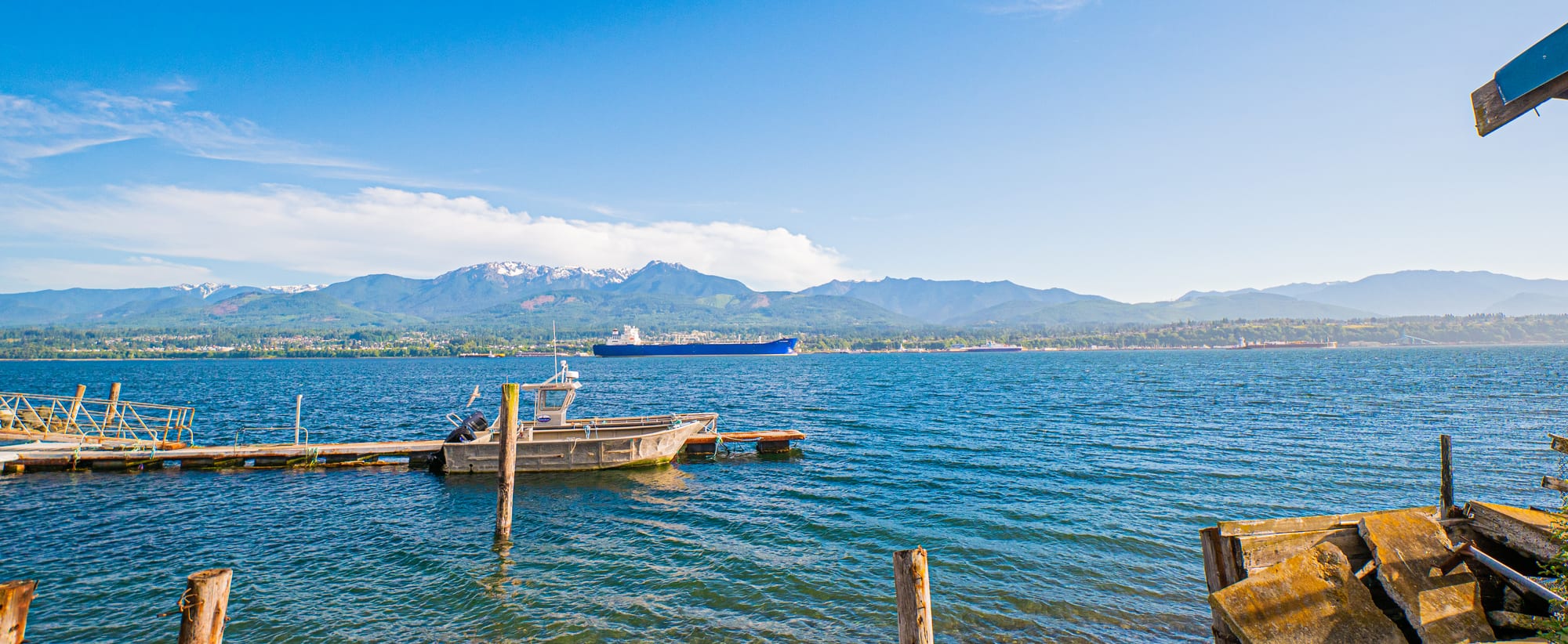
Blue harbour water with a small boat at a wooden jetty, a cargo ship at anchor and the snow-tipped Olympic Mountains behind the town

The Pacific Northwest, United States

Port Angeles

Port Angeles Harbor and the Olympic Mountains seen from Ediz Hook. (ReachOutAndTouch / Wikimedia Commons · CC BY-SA 4.0)

The largest town on Washington's Olympic Peninsula, on a deep harbour sheltered by the sand spit of Ediz Hook, facing Victoria across the Strait of Juan de Fuca. Built on a Klallam village site and grown on timber and pulp mills, it is now the headquarters of Olympic National Park and the main gateway to Hurricane Ridge and Lake Crescent.

Neighbourhoods

  • Downtown and the waterfront
    • First-time visitors
    • Best for food
    • Close to the ferry

    The grid of streets behind the ferry terminal and City Pier, with shops, cafés, restaurants, the marine life centre and the main bus station. The waterfront trail runs along the harbour from here towards Ediz Hook.

    Open in Maps
  • The hillside and south side
    • Quiet and residential
    • Mountain views

    Residential streets climbing the bluff above downtown towards the foothills, with views over the strait to Vancouver Island and the national park visitor centre on the road up to Hurricane Ridge.

    Open in Maps
  • Ediz Hook and the west harbour
    • Walks
    • Wildlife

    The narrow natural spit curving almost three miles into the strait, sheltering the harbour, with a road, shoreline walks and a Coast Guard air station at its tip.

    Open in Maps

Things to do

In town

  • Ediz Hookviewpoint

    A 3-mile sand spit that shelters the town's deep natural harbour, with views back across the water to the Olympic Mountains and north to Victoria.

    Open in Maps
  • Feiro Marine Life Centermuseum

    A marine life centre on Lincoln Street beside City Pier.

    Open in Maps
  • Elwha Klallam Museummuseum

    The Lower Elwha Klallam Tribe's museum of cultural and historical objects, in the town's old Carnegie Library building.

    Open in Maps
  • Olympic Discovery Trailtrail

    A walking and cycling trail that passes through town on its way across the peninsula from Port Townsend towards La Push.

    Open in Maps

Olympic National Park

  • Hurricane Ridgeviewpoint

    A mountain ridge about 18 miles by road from town, one of the two most visited places in the national park, with meadows, trails and views of the Olympic peaks. Its day lodge burned down in May 2023; as of May 2025 the rebuilding was on hold.

    Open in Maps
  • Lake Crescentpark

    A deep lake in a valley carved by Ice Age glaciers, about 17 miles west of town on U.S. Route 101, with trails including one to Marymere Falls.

    Open in Maps
  • Elwha Riverpark

    The river west of town where the removal of two dams was the National Park Service's second-largest ecosystem restoration project, after the Everglades.

    Open in Maps

Short trips from the town

  • Olympic National Parkpark

    A UNESCO World Heritage Site covering most of the Olympic Mountains, with glaciated peaks, rainforest valleys and wild Pacific beaches; its headquarters are in Port Angeles.

    Open in Maps
  • Hoh Rainforestpark

    The wettest forest in the contiguous United States, a temperate rainforest of Sitka spruce and western hemlock rich in mosses and lichens, and with Hurricane Ridge one of the two most visited sites in the national park.

    Open in Maps
  • Dungeness Spitpark

    The longest natural sand spit in the United States, about 5 miles long and lying entirely within a national wildlife refuge east of town near Sequim, with the New Dungeness Lighthouse on the spit.

    Open in Maps

Eat and drink

Long-standing places and food districts in Port Angeles. Hours, ratings and directions come from your maps app, always current.

Food on the Strait

  • Downtown restaurantsneighborhood

    Cafés, seafood restaurants, bakeries and brewpubs on the streets behind the ferry terminal, where Dungeness crab and salmon are the local specialities.

    Open in Maps
  • City Pierneighborhood

    The town pier at the end of Lincoln Street, where local people fish for crab and shrimp.

    Open in Maps

Experience Port Angeles

History

The shore of the harbour was home to the Klallam people, whose village of Tse-whit-zen stood on the beach at the foot of Ediz Hook. Diseases brought by outsiders killed many of them in 1780 and 1835. In 1791 the Spanish explorer Francisco de Eliza sailed into the harbour and named it Puerto de Nuestra Señora de los Ángeles, Port of Our Lady of the Angels. A small whaling, fishing and shipping village grew up, trading across the strait with Victoria, and in the 1860s President Abraham Lincoln set aside 3,520 acres here as a federal reserve for a lighthouse and military and naval use — the reason the town was later promoted as the "Second National City".

Growth came late. A village of 300 in 1886 had 3,000 people by 1890, hundreds of them members of the Puget Sound Cooperative Colony, founded in 1887, which built a sawmill, church and opera house among the settlement's first permanent civic facilities. Port Angeles was incorporated in 1890 and became the seat of Clallam County. Large-scale logging began in 1914 with a big mill and a railway into the forests, and lumber and pulp mills carried the economy for most of the century.

The mills began to close in the 1970s and 1980s, and the Rayonier pulp mill shut in 1997, while tourism to Olympic National Park grew in importance. In 2003 work on a dry dock for the Hood Canal Bridge uncovered the remains of Tse-whit-zen, with about 300 graves and many ritual and ceremonial objects of the Lower Elwha Klallam Tribe.

Culture & Customs

Port Angeles is a working harbour town with an outdoor life on its doorstep. The national park's headquarters and main visitor centre are here, and people come to hike, fish, kayak and cycle; the Olympic Discovery Trail runs right through the town. The view north across the Strait of Juan de Fuca to Vancouver Island and Victoria, and south to the Olympic Mountains, defines the place.

The Lower Elwha Klallam Tribe has a strong presence. Its museum occupies the old Carnegie Library, the excavation at Tse-whit-zen brought Klallam history to the centre of public life, and street signs in English and Klallam were put up in 2016 to help keep the language alive. The removal of the two dams on the Elwha River, which had blocked the river's salmon runs from 1911 to 2014, was the National Park Service's second-largest ecosystem restoration project, after the Everglades.

Peninsula College, the community college for the peninsula, is based in the town, and the Peninsula Daily News serves the whole north peninsula. The harbour with the mountains behind it appeared in the final scene of the 1994 film Wyatt Earp.

Daily Life

Port Angeles had 19,960 people at the 2020 census and an estimated 20,112 in 2024, making it the largest city on the Olympic Peninsula. It is the seat of Clallam County, spread over the bluffs above the harbour, and covers about 14.5 square miles, a quarter of it water. The median age was 41.3 in the 2022 American Community Survey.

With most of the mills gone, tourism and public bodies loom large — the county, the national park, the Coast Guard station on Ediz Hook and Peninsula College. About 11 per cent of residents lived at or below the poverty line in the 2022 survey.

Life follows the seasons. Summer brings visitors through on their way to Hurricane Ridge and Lake Crescent, and the ferry to Victoria runs more often; winter is quiet, mild and grey. The rain shadow of the mountains gives the town far less rain than the rest of western Washington.

Food

The waters of the strait and the peninsula shape the menu. Dungeness crab is named after Dungeness Spit, east of town, and appears in crab cakes, sandwiches and whole on the plate; salmon, halibut, oysters and clams fill out the seafood. People still fish for crab and shrimp from City Pier, the main outdoor civic space downtown, which has a lookout tower over the inner harbour.

Downtown has cafés, bakeries, brewpubs and seafood restaurants within a few blocks of the ferry terminal, many busiest in summer when park visitors pass through. The wider state supplies apples and sweet cherries, of which Washington is the largest US producer, and Washington wine.

Salmon carries special meaning here. The Elwha dams blocked the river's salmon runs for most of the 20th century, and the river's recovery since the dams came down is followed closely. Smoked salmon and salmon grilled on a cedar plank, techniques often used in Pacific Northwest cooking, are the local classics.

Planning tools

Budget

Port Angeles is cheaper than Seattle or the San Juan Islands, with motels and chain hotels the main places to stay. Costs come from the national park entrance fee, fuel for long drives around the peninsula and the ferry to Victoria. Washington has a high sales tax, added at the till.

Daily Budget Midrange
USD 230–400 (mid-range hotel, restaurant dinners with tips and tax, national park pass, hire car and fuel)
Daily Budget Shoestring
USD 100–160 (campground or budget motel, self-catering and takeaway, own car or buses)

Visitors seeing several national parks can save with the America the Beautiful annual pass; book summer rooms early.

Best Time to Visit

July to September is the reliable season, when Hurricane Ridge's meadows are clear of snow and the weather is mostly dry. Spring and autumn are quieter and greener. In winter the town is mild and less wet than most of western Washington, and the ridge can be visited for snowshoeing and skiing when the road is open.

Suggested Number of Days

Two or three days give time for the town and the nearest parts of the national park. Four to six allow a loop of the wider peninsula and its Pacific coast, or a crossing to Victoria.

First Visit
2–3 days
With Surroundings
4–6 days

Transportation

The town is small and easily covered on foot or by bike along the waterfront trail. Clallam Transit buses serve the town and the peninsula, but the national park sites are far apart and a car is the practical way to reach them.

Hurricane Ridge Road is steep and winding and can be closed by snow; check the national park's road status before driving up.

Airport & Station Connections

Most visitors drive from Seattle, crossing Puget Sound by ferry or by the Tacoma Narrows Bridge and then the Hood Canal Bridge. Olympic Bus Lines runs coaches to the main bus station downtown. William R. Fairchild International Airport lies on the west side of town. The MV Coho of the Black Ball Line sails to Victoria, British Columbia, two to four times a day depending on the season, a crossing of about 90 minutes.

Walkability

Downtown and the waterfront are compact and easy to walk, and the waterfront trail continues for miles along the shore. The town climbs steeply from the harbour, so the residential streets mean some hills.

Safety

For most visitors the US is safe, with the main risks being petty theft and car break-ins in tourist areas of some cities, road accidents over long distances, extreme weather, and the hazards of the outdoors. Around Port Angeles the risks are those of the park: mountain weather, cold rivers and lakes, and long drives on winding roads.

Check weather and park-service alerts before hiking, carry layers even in summer at Hurricane Ridge, and keep valuables out of sight at trailhead car parks. Check current official travel advice before travelling.

Climate

A mild maritime climate in the rain shadow of the Olympic Mountains, with only about 25 inches of rain a year — far less than Seattle and a quarter of what falls at Forks to the west. Summers are much cooler than Seattle's.

Summer
mild and mostly dry — highs rarely above 80°F, though a record 97°F was set in June 2021
Winter
cool and damp but rarely severe — lows seldom fall below 25°F in town, while Hurricane Ridge above is snowy

Local Customs

Tipping of roughly 18–22 per cent in restaurants is expected, and about a dollar a drink at a bar. Dress is outdoor-casual. The Lower Elwha Klallam Tribe is part of the town's life, and since 2016 some street signs have been written in both English and Klallam.

Respect Klallam sites and museum rules on photography. Identification is asked for when buying alcohol (the legal age is 21).

Common Payment Methods

The currency is the US dollar. Cards and contactless payment are accepted almost everywhere. Sales tax is added at the till.