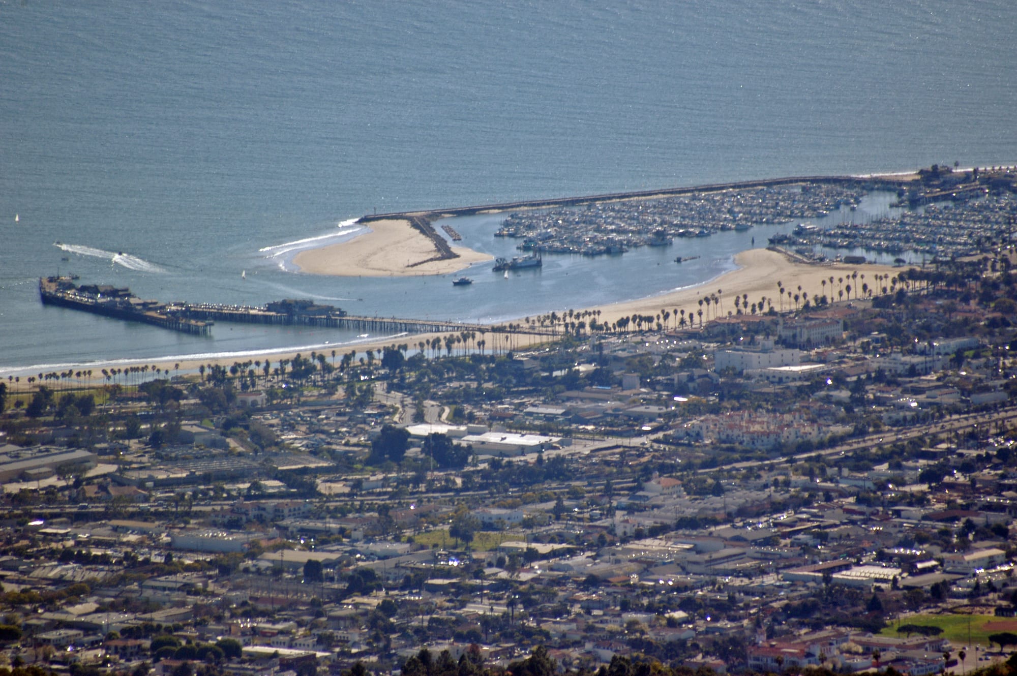
Santa Barbara's low-rise city and palm-lined beach seen from above, with Stearns Wharf, the harbour and its breakwater

California, United States

Santa Barbara

Santa Barbara's waterfront from the hills, with Stearns Wharf, the beaches and the harbour behind its breakwater. (Damian Gadal / Wikimedia Commons · CC BY 2.0)

A coastal city on a south-facing stretch of the California shore, between the Santa Ynez Mountains and the Pacific, about 100 miles north-west of Los Angeles. Founded around a Spanish presidio and mission, it was rebuilt in Spanish Colonial Revival style after the 1925 earthquake and is now a university, resort and wine-tasting town of red-tiled roofs, palm-lined beaches and mountain views.

Neighbourhoods

  • Downtown and State Street
    • First-time visitors
    • Shopping
    • Arts and culture

    The historic core along State Street, from the Granada Theatre down towards the beach, with the courthouse, the Presidio, the art museum and the Paseo Nuevo shopping centre. Eight blocks of State Street are closed to cars and open to walkers and cyclists, and the side streets are full of Spanish Colonial Revival arcades and courtyards.

    Open in Maps
  • The Funk Zone
    • Wine tasting
    • Nightlife
    • Best for food

    The old industrial blocks just east of lower State Street, between the waterfront and Highway 101, now filled with wine-tasting rooms, craft breweries, galleries and restaurants. It has a younger, more informal feel than the rest of the city and is a short walk from the train station and Stearns Wharf.

    Open in Maps
  • The Waterfront
    • Beaches
    • Families
    • Walks

    Cabrillo Boulevard runs along the shore past East Beach and West Beach, Stearns Wharf, the harbour and the breakwater, with a bike path, palms and many of the city's beach hotels. The zoo and the Andrée Clark Bird Refuge lie at its eastern end.

    Open in Maps
  • The Upper Eastside and the Riviera
    • Quiet and residential
    • Views
    • Historic sights

    Residential streets climb from Alameda Park towards the mission, the natural history museum and Mission Canyon. Above them the Riviera, a steep ridge of hillside houses along Alameda Padre Serra, has wide views over the city to the ocean.

    Open in Maps
  • The Eastside and Milpas Street
    • Best for food
    • Local life

    The heart of Santa Barbara's large Latino community, east of State Street. The Milpas Street corridor, running from the Santa Barbara Bowl down to the waterfront, is the city's second commercial strip, lined with taquerías, Mexican restaurants and everyday shops.

    Open in Maps
  • Montecito
    • Gardens
    • Upmarket stays
    • Quiet and residential

    An unincorporated town immediately east of the city, between the mountains and the sea, known for its large estates and wealthy residents. It has a small village centre, gardens open to visitors and upmarket resorts set among oak woodland.

    Open in Maps

Things to do

Historic landmarks

  • Mission Santa Barbaralandmark

    Founded on 4 December 1786 as the tenth of California's Spanish missions and called the 'Queen of the Missions', it has been run by Franciscan friars since its founding and is still a parish church.

    Open in Maps
  • Santa Barbara County Courthouselandmark

    A red-tiled Spanish Colonial Revival courthouse completed in 1929, now a National Historic Landmark, with a Mural Room painted with scenes of local history and a clock tower with an observation deck over downtown.

    Open in Maps
  • El Presidio de Santa Barbara State Historic Parklandmark

    The site of the Spanish fort built in 1782, the last military outpost Spain founded in the Americas, with El Cuartel, the second-oldest surviving building in California, and ongoing archaeological work.

    Open in Maps
  • Stearns Wharflandmark

    The pier at the foot of State Street, completed in 1872 as the longest deep-water pier between Los Angeles and San Francisco, now lined with shops, restaurants and the natural history museum's Sea Center.

    Open in Maps

Museums

  • Santa Barbara Museum of Artmuseum

    A downtown museum on State Street, founded in 1941, with Asian, American and European collections spanning some 4,000 years.

    Open in Maps
  • Santa Barbara Museum of Natural Historymuseum

    A museum beside Mission Creek in Mission Canyon, above the mission, with exhibits on local wildlife, marine life and the history of the Chumash people, and a planetarium.

    Open in Maps

Beaches, gardens and the waterfront

  • East Beachbeach

    The main beach for visitors, east of Stearns Wharf along Cabrillo Boulevard, known for its volleyball tournaments.

    Open in Maps
  • Arroyo Burro Beachbeach

    Called Hendry's Beach by locals, a beach below the coastal bluffs at the western end of the Mesa, popular with surfers and dog walkers.

    Open in Maps
  • Santa Barbara Zooattraction

    A small zoo near the ocean, opened in 1963, with more than 500 animals, including California condors, and a miniature train.

    Open in Maps
  • Santa Barbara Botanic Gardenpark

    A garden of California native plants in Mission Canyon, with miles of trails and a rock dam built in 1806 under the direction of the mission's padres; it marked its centenary in 2026.

    Open in Maps
  • Lotuslandpark

    The former Montecito estate of the opera singer Ganna Walska, now a botanical garden of about 3,500 kinds of plants, open to the public by reservation only.

    Open in Maps

Music, film and nights out

  • Santa Barbara Bowlattraction

    An outdoor amphitheatre of about 4,500 seats in a canyon at the base of the Riviera, holding popular-music concerts from roughly spring to autumn.

    Open in Maps
  • Funk Zone tasting roomsneighborhood

    Wineries, craft breweries and distillers in converted industrial buildings, part of what is known as the Urban Wine Trail, a few blocks from the beach.

    Open in Maps

Short trips from the city

  • Solvangattraction

    A town in the Santa Ynez Valley founded in 1911 by Danish Americans, known for its Danish-style architecture, beside the Spanish mission of Santa Inés founded in 1804.

    Open in Maps
  • Santa Ynez Valley wine countryattraction

    The valley north of the Santa Ynez Mountains, with its small towns and many wineries and vineyards, reached from the city over Highway 154.

    Open in Maps

Seasonal events

  • Santa Barbara International Film FestivalFebruary

    An eleven-day festival held since 1986, screening more than 200 features and shorts, with tributes and panels, centred on the 2,000-seat Arlington Theatre.

  • I MadonnariMemorial Day weekend, late May

    A chalk-art festival in which artists cover the paving in front of the mission with temporary pictures, with food stalls and music.

  • Summer Solstice ParadeThe first weekend after the summer solstice, June

    A parade of home-made floats and costumes held since 1974, the largest single-day event in the county, drawing crowds of 100,000 or more.

  • Santa Barbara French FestivalBastille Day weekend, July

    A festival of French food, music and dance, described as the largest French festival in the western United States.

  • Fiesta (Old Spanish Days)August

    The city's biggest festival, started in the 1920s, celebrating its Spanish and Mexican heritage with parades, flamenco and mariachi performances and food stalls.

Eat and drink

Long-standing places and food districts in Santa Barbara. Hours, ratings and directions come from your maps app, always current.

Santa Barbara classics

  • La Super-Rica Taqueriarestaurant

    A small taquería on the Eastside, said to have been Julia Child's favourite Mexican restaurant.

    Open in Maps
  • Stearns Wharf and the harbourneighborhood

    Seafood restaurants on the wharf and around the harbour, where sea-urchin boats land their catch, whose roe is eaten as uni.

    Open in Maps

Food districts and markets

  • Milpas Street taqueríasneighborhood

    The Eastside's main street, with a dense run of taquerías and Mexican restaurants serving the city's large Latino community.

    Open in Maps
  • Santa Barbara Farmers Marketmarket

    The downtown farmers' market at Cota and Santa Barbara streets, selling fruit, vegetables, flowers and produce from the surrounding farms and coast.

    Open in Maps

Wine and bars

  • The Funk Zoneneighborhood

    Tasting rooms, craft breweries and casual restaurants in the blocks east of lower State Street — the easiest way to taste Santa Barbara County wine without driving.

    Open in Maps

Experience Santa Barbara

History

Long before Europeans arrived, the coast here was Chumash country. At least 25,000 Chumash lived in the region before Spanish contact, and five villages stood in what is now the city; a mound on Mason Street is thought to be the site of the village of Syujton, recorded by Juan Rodríguez Cabrillo in 1542. Spanish soldiers and missionaries under Felipe de Neve arrived in 1782 and built the Presidio, the last military outpost Spain founded in its American colonies, and the mission followed on the feast of Saint Barbara, 4 December 1786. Livestock, epidemics and military force left the Chumash little choice but to join the mission system.

After Mexican independence in 1821 the missions were secularised and their lands divided into great cattle ranchos. John C. Frémont took the town for the United States on 27 December 1846, during the Mexican–American War. Stearns Wharf, completed in 1872, and the railway link to Los Angeles, completed in 1887, opened Santa Barbara to visitors. On 29 June 1925 a magnitude 6.3 earthquake damaged much of downtown and killed 13 people. City leaders used the rebuilding to encourage a unified Spanish Colonial Revival style through design guidelines, and the courthouse, finished in 1929, became its showpiece.

After the Second World War the university campus nearby became a major employer, and in 1975 the city limited future density to protect its water supply and character — a decision that kept sprawl out but made housing scarce and expensive. Fire is a recurring threat: the Tea Fire of 2008 and the Jesusita Fire of 2009 destroyed hundreds of homes in the foothills, and the Thomas Fire of December 2017, the most damaging in the county's history, was followed in January 2018 by mudflows in neighbouring Montecito that killed 23 people.

Culture & Customs

Santa Barbara's look is its culture. Red-tile roofs, white walls, arcades and tiled courtyards were encouraged by design guidelines adopted after 1925, and the result is a strikingly unified townscape, centred on the courthouse with its painted Mural Room and on the mission, still run by the Franciscans. The city's Spanish and Mexican past is celebrated every August at the Fiesta, or Old Spanish Days, begun in the 1920s, with parades, flamenco and mariachi music around town.

Hispanic or Latino residents make up almost two-fifths of the population, and the Eastside around Milpas Street is the centre of that community. The arts are well supported for a city of its size: the Arlington Theatre, with about 2,000 seats, hosts the Santa Barbara International Film Festival each winter; the restored Granada Theatre and the outdoor Santa Barbara Bowl hold concerts; and the Music Academy of the West in Montecito runs a summer music festival. The Summer Solstice Parade, started in 1974, fills State Street with home-made floats and costumes, and on Memorial Day weekend chalk artists cover the paving in front of the mission for I Madonnari.

The university gives the area a young, outdoor-minded population of students, surfers, cyclists and hikers, alongside a large retired and wealthy community in Montecito and Hope Ranch. Wine is part of local identity too, from the tasting rooms of the Funk Zone to the vineyards of the Santa Ynez Valley over the mountains.

Daily Life

About 89,000 people lived in the city at the 2020 census, with more in neighbouring Goleta, Montecito and Carpinteria along the same narrow coastal strip. The city covers an unusual shape: a thin corridor of city limits runs out under the sea and back inland so that the airport, beside UCSB near Goleta, sits within its boundary.

Tourism brings more than a billion dollars a year into the local economy, but in the county as a whole government is the largest employer, followed by private education and healthcare, then leisure and hospitality. UCSB, Santa Barbara City College and Westmont College give the area a large student population. Housing is the constant issue: growth limits, high demand from second-home buyers and retirees, and little land between the mountains and the sea have pushed prices far beyond what most residents can afford — in 2006 only six per cent could afford a median-value house.

Daily life is relaxed and outdoors — morning walks and runs along the waterfront path, surfing at the local breaks, hiking in the foothills, the farmers' market downtown — and residents are well aware of living with fire, drought and the risk of mudflows. The Riviera's hillside houses and Montecito's estates contrast with the busier, more crowded streets of the Eastside and Westside.

Food

Santa Barbara cooks with what is near at hand: fresh produce from farms within a few hundred miles, sold at the downtown farmers' market, and seafood landed in the harbour, including sea urchins whose roe, uni, was once shipped almost entirely to Japan and is now eaten locally. Seafood restaurants stand on Stearns Wharf and around the harbour.

Mexican food is everyday food. The Eastside, around Milpas Street, has a great many taquerías and Mexican restaurants, from small counters making tacos to order to family restaurants serving seafood enchiladas, including La Super-Rica Taqueria, said to have been a favourite of Julia Child. The Central Coast tradition of Santa Maria-style barbecue — tri-tip beef grilled over oak — turns up as tri-tip sandwiches. A less expected local claim: the Egg McMuffin was invented at the McDonald's on upper State Street.

Wine is the region's best-known product. Pinot Noir and, to a lesser extent, Chardonnay are the signature varieties of Santa Barbara County, grown in the cooler valleys north of the mountains, and the Funk Zone has many tasting rooms within a few blocks of the beach. Craft breweries and small distilleries have joined them in the old industrial buildings, and the autumn harvest is the busiest season in the vineyards.

Planning tools

Budget

Santa Barbara is one of the more expensive small cities in California. Hotels near the beach and in Montecito are dear, especially at summer weekends and during the Fiesta and the film festival, and restaurant and wine-tasting costs add up quickly. Prices are lower in winter and on weekdays, and the beaches, the waterfront path and the courthouse tower cost nothing.

Daily Budget Midrange
USD 260–480 (mid-range hotel, restaurants with tax and tips, a museum and some wine tasting, a hire car for wine country)
Daily Budget Shoestring
USD 120–190 (hostel bed or motel, taquerías and the farmers' market, city buses, the downtown shuttle and bike share)

Stay downtown or near the Funk Zone to walk everywhere; book well ahead for summer weekends and the Fiesta in August.

Best Time to Visit

The weather is mild all year, with highs typically in the 60s °F in winter and the 70s to low 80s °F in summer. Spring and autumn are quieter than the peak summer months, and autumn brings the grape harvest in the Santa Ynez Valley. Summer has the festivals and the busiest beaches. In autumn the hot, dry 'Sundowner' winds can raise the fire risk in the foothills.

Suggested Number of Days

Two or three days cover the city itself. Four or five allow time for the inland wine country and the towns of the Santa Ynez Valley as well. A car makes the longer stay easier, since the valley is over the mountains.

First Visit
2–3 days
With Surroundings
4–5 days

Transportation

The Santa Barbara Metropolitan Transit District runs buses across the city and to Goleta, Montecito and Carpinteria, and electric shuttles along State Street and the waterfront. There is a bike-share scheme with electric bikes, a bike path along the shore, and a car-free stretch of State Street. Parking is usually not hard to find in municipal garages or on the street. A car is the practical way to reach the Santa Ynez Valley.

Leave the car in a downtown garage and use the shuttles and bike share in town; hire one only for the wine country.

Airport & Station Connections

Santa Barbara Municipal Airport is about 7 miles west of downtown, near Goleta and the UCSB campus, with flights from several major US airlines. Many visitors fly into Los Angeles instead and come up by road along US Highway 101 — Los Angeles is about 100 miles to the south-east — or by airport shuttle. Amtrak's Pacific Surfliner and Coast Starlight trains stop at the station on lower State Street.

Walkability

Downtown, the Funk Zone and the waterfront are flat, close together and easy on foot, with the car-free part of State Street and the beachfront path the most pleasant routes. The mission, the natural history museum and the Riviera are uphill from downtown, and the Mesa and Montecito are easier by bus, bike or car.

Safety

For most visitors the US is safe, with the main risks being petty theft and car break-ins in tourist areas of some cities, road accidents over long distances, extreme weather, and the hazards of the outdoors. Santa Barbara is generally calm, and the greater risks are natural: wildfires in the foothills, driven by the Sundowner winds, and the mudflows that can follow heavy rain on burned slopes — the Thomas Fire of December 2017 was followed in January 2018 by mudflows in Montecito that killed 23 people.

Follow fire and evacuation orders at once, keep valuables out of sight in parked cars at beaches and trailheads, and swim near lifeguard towers. Check current official travel advice before travelling.

Climate

A warm-summer Mediterranean climate, often compared with the Riviera: dry, sunny summers with very few days above 90°F, and mild winters with most of the year's rain. In autumn the Sundowner winds can briefly push temperatures into the high 90s °F.

Summer
June to August highs are mostly 72–84°F, and the weather is dry
Winter
most days from December to February reach 63–69°F, with cooler days and the main rains

Local Customs

Tipping of roughly 18–22 per cent in restaurants is expected, and sales tax is added at the till. Dress is relaxed and casual almost everywhere. The mission is a working parish church, so visitors keep quiet and dress modestly inside and during services. The city's Spanish and Mexican heritage is a strong part of local identity, celebrated each August at the Fiesta.

The legal drinking age is 21, and identification is asked for when buying alcohol and at tasting rooms.

Common Payment Methods

The currency is the US dollar. Cards and contactless payment are accepted almost everywhere, including at tasting rooms and most market stalls. ATMs are easy to find downtown. A little cash is useful for small taquerías and tips.