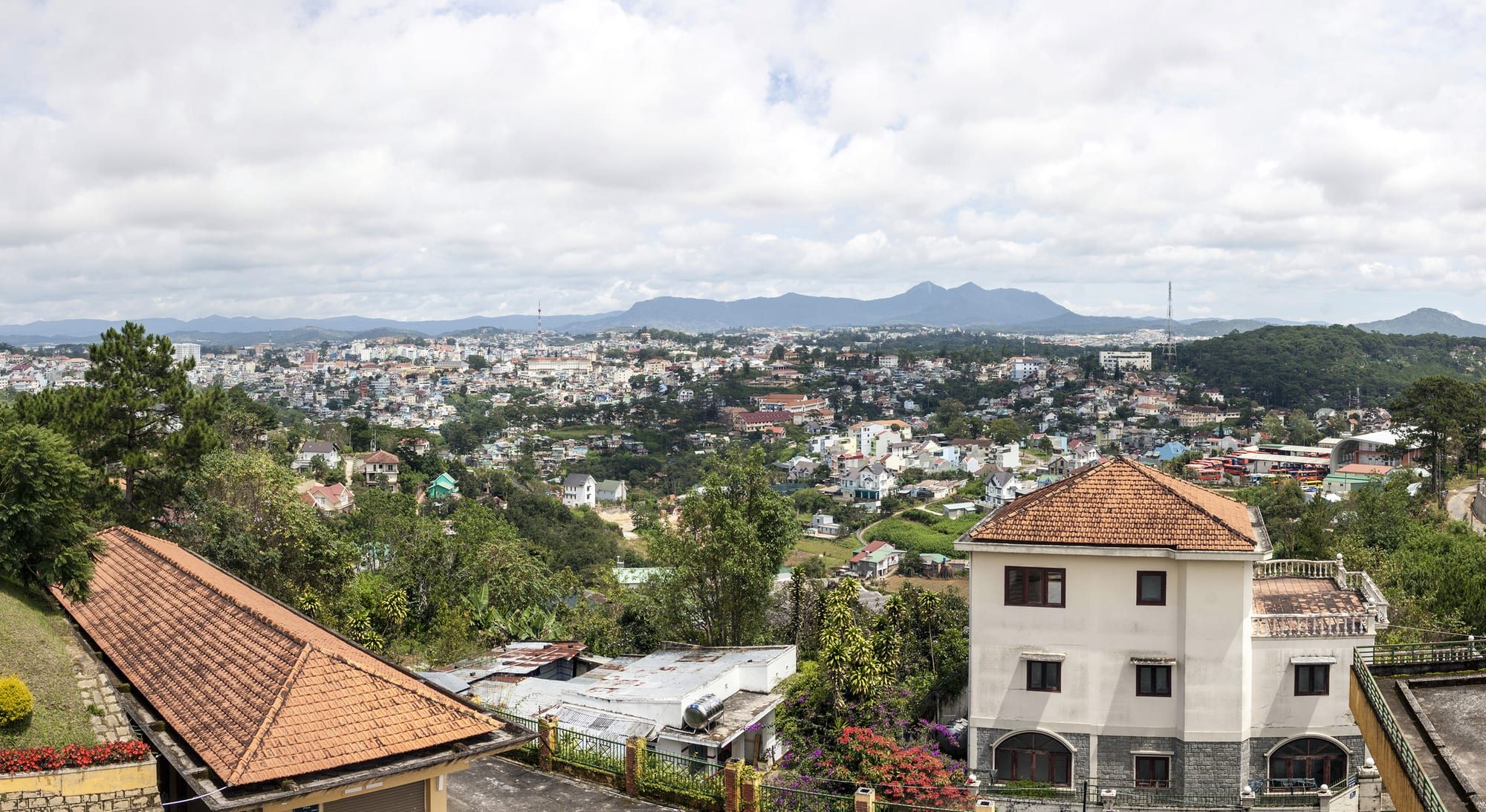
A hillside town of pale houses with orange tiled roofs spread across green valleys, with forested mountains on the horizon

Ho Chi Minh City, Da Lat & the Southeast, Vietnam

Da Lat

Da Lat spread across the hills of the Lâm Viên plateau. (Castelfranco / Wikimedia Commons · CC BY-SA 4.0)

A highland town at about 1,500 metres on the Lâm Viên plateau, founded by the French as a hill station to escape the heat of the lowlands. Pine forest, a lake in the middle of town, villas with chimneys and terraced farms under greenhouses give it a character unlike anywhere else in Vietnam, and it remains a favourite escape for Vietnamese travellers.

Neighbourhoods

  • The centre around the market
    • First-time visitors
    • Best for food
    • Nightlife

    The bowl of streets below the old cinema and around the terraced market building, with the night market spilling down the steps, most of the hotels, and the lake a few minutes' walk away. Everything in the town's compact core is reachable on foot from here.

    Open in Maps
  • The lakeside and the villa quarter
    • Quiet and residential
    • Architecture
    • Walks

    The shore of Xuân Hương Lake and the wooded slopes south and west of it, where French-era villas with steep roofs and chimneys line curving roads. Several have become hotels and cafés, and the golf course, the flower gardens and the old railway station are on this side.

    Open in Maps
  • Trại Mát and the eastern edge
    • Local life
    • Day trips

    The farming stretch east of town along the old railway, a landscape of greenhouses, vegetable plots and flower nurseries. The heritage train runs out here to a much-decorated mosaic pagoda.

    Open in Maps
  • Tuyền Lâm and the pine forest
    • Nature
    • Quiet and residential

    South-west of the centre, where the built-up area gives way to pine woods, a large reservoir with boat landings, a Zen monastery on a hill above it and a cable car running down from the town.

    Open in Maps

Things to do

In the town

  • Xuân Hương Lakeattraction

    The crescent-shaped artificial lake at the centre of town, made by damming a stream in the colonial period, with a path of a few kilometres around it.

    Open in Maps
  • Da Lat railway stationtransit hub

    A 1930s Art Deco station with three steep coloured gables, the terminus of the old cog railway from the coast; a short heritage line still runs from it to Trại Mát.

    Open in Maps
  • Hang Nga guesthouseattraction

    Known as the Crazy House, a guesthouse opened in 1990 as a warren of organic concrete forms, tunnels and staircases resembling a hollow tree.

    Open in Maps
  • St. Nicholas Cathedrallandmark

    The cathedral completed in 1942, with a weathercock on its spire, known locally as the Chicken Church, on the road east of the lake.

    Open in Maps
  • Dinh IIIlandmark

    The summer palace built for Emperor Bảo Đại in the 1930s, a low Art Deco villa in pine grounds south-west of the centre, kept with its original furnishings.

    Open in Maps

Pagodas

  • Trúc Lâm Templelandmark

    A Zen monastery of the 1990s on a pine-covered hill above Tuyền Lâm Lake, reached by road or by the cable car from the edge of town.

    Open in Maps
  • Linh Phước Templelandmark

    A temple at Trại Mát, built between 1949 and 1952 and covered inside and out in mosaics of broken glass and porcelain, with a long mosaic dragon in its garden.

    Open in Maps

Lakes and forest

  • Tuyền Lâm Lakeattraction

    A reservoir in the pine forest south of town, with inlets, boat trips and walking tracks through the plantations around it.

    Open in Maps
  • Bidoup Núi Bà National Parkpark

    A large park of montane pine and evergreen forest north-east of the town, known for birdwatching, orchids and long trails.

    Open in Maps
  • Lang Biangviewpoint

    The mountain group about 12 kilometres north of the town, whose highest summits, Núi Bà at 2,167 metres and Núi Ông at 2,124 metres, rise above the plateau; a lower radar hill is reached by road.

    Open in Maps
  • Datanla waterfallattraction

    A fall of about 20 metres in forest some 10 kilometres south of the centre, below the road towards the Prenn pass.

    Open in Maps
  • Prenn waterfallattraction

    A curtain of water at the foot of the Prenn pass, about 10 kilometres south of the town, set in laid-out gardens and pine woods.

    Open in Maps

Seasonal events

  • Da Lat Flower Festivalevery other year, usually in December

    A festival of flower displays, street parades and exhibitions staged by the town in the dry season, held every other year.

  • Tếtlate January or February

    The lunar new year, when the flower farms sell their biggest crop of the year and domestic visitors fill the town.

  • Coffee and harvest seasonNovember to January

    The arabica harvest on the slopes around the town, when drying floors appear in farmyards and roasters are busiest.

Eat and drink

Long-standing places and food districts in Da Lat. Hours, ratings and directions come from your maps app, always current.

Da Lat classics

  • Bánh tráng nướng stallsneighborhood

    Rice paper grilled over charcoal with egg, dried shrimp, spring onion and chilli — the town's street snack, sold from braziers around the market steps.

    Open in Maps
  • Night market food stallsmarket

    The stepped market street, where stalls sell grilled sweetcorn and sweet potato, hot soy milk, sticky rice and bowls of noodles to people wrapped up against the cold.

    Open in Maps
  • Da Lat central marketmarket

    The terraced covered market, stacked with artichokes, strawberries, avocados, dried fruit, jams, candied vegetables and flowers from the farms around the town.

    Open in Maps

Cafés and drinks

  • Garden and hillside caféscafe

    Coffee houses in old villas, on terraces above the valleys and among pines, serving arabica grown on the plateau, hot rather than iced in the cool air.

    Open in Maps
  • Vang Đà Lạt winecafe

    The locally made wine, produced in the town from a mix of imported and local fruit, sold in shops and served in most restaurants.

    Open in Maps

Experience Da Lat

History

The plateau was the country of the K'Ho, Chil and Lạch peoples, who farmed and hunted its forests long before the French arrived; the name Đà Lạt derives from a phrase meaning the stream of the Lạch. In the 1890s the Swiss-French doctor Alexandre Yersin, better known for identifying the plague bacillus, explored the Lâm Viên plateau and recommended its climate to the colonial authorities as a place where Europeans could recover from the heat of the delta. Governor-General Paul Doumer took up the idea, and from the early 1900s a hill station was laid out around a dammed stream.

Villas, a lycée, a golf course, sanatoria and hotels followed, along with a cog railway climbing from the coastal plain, completed in the 1930s, and an Art Deco station to receive it. The town became the summer capital in all but name: Emperor Bảo Đại built palaces here, colonial officials came for the season, and the plateau's flower and vegetable farms were established to supply European tastes.

Da Lat came through the war years with little damage, and after 1975 it kept its role as a resort, this time for Vietnamese visitors, alongside a fast-growing agriculture of greenhouses and cut flowers. The railway to the coast was closed and dismantled, leaving only the short stretch to Trại Mát. Since the 1990s tourism and intensive farming have expanded together, filling the valleys with plastic-covered houses and the ridges with hotels, and the town has spread well beyond its colonial outline.

Culture & Customs

Da Lat is the Vietnamese idea of a romantic town: cool air, pine trees, mist, and a long association with honeymoons, poetry and love songs. Much of its domestic tourism runs on that reputation, from lakeside cafés to the photographs taken in flower gardens and among the farms. It is also a student town, with a university founded in 1957, and has a small community of artists and musicians.

The architectural legacy is unusual in Vietnam: hundreds of French-era villas with chimneys, dormer windows and gardens, a cathedral, convents and the railway station, many of them now hotels, cafés or government offices. Preserving them against redevelopment is a running local argument. Christianity is strong here, Catholic and Protestant alike, and church spires are as prominent as pagodas.

The K'Ho and other highland communities of the surrounding districts keep gong music, back-strap weaving and their own languages, and their villages sit close to the town on the road to Lang Biang. Visitors encounter these traditions mostly through organised performances and craft cooperatives, and the respectful approach is to treat village visits as a visit to people's homes rather than a display. Everyday manners are Vietnamese and unhurried, with the cold evenings pushing social life indoors around hot drinks.

Daily Life

Around 200,000 people live in the town, and it is the largest settlement of the Lâm Viên plateau. Agriculture and tourism carry the economy between them: the plateau grows most of Vietnam's temperate vegetables and cut flowers under greenhouses, along with strawberries, avocados, artichokes, tea and arabica coffee, and these are trucked to Ho Chi Minh City daily. Hotels, homestays, cafés and tour operators employ much of the rest, and the university brings students from across the south.

Mornings begin early and cold, with markets busy at dawn and farmers already at work under the plastic. The middle of the day is mild, and evenings are spent indoors or around braziers at the night market, which is the town's main gathering place. Weekends bring a large influx from Ho Chi Minh City, filling the roads into town on Friday evening.

The pressures are visible. Greenhouses have replaced much of the pine forest in the valleys, water for irrigation is under strain, and construction on the slopes has led to landslides in heavy rain. Housing costs have risen with tourism, and the balance between farming, building and the scenery that draws visitors is the town's central question.

Food

Da Lat cooks for the cold, which makes it unlike the rest of southern Vietnam. Bánh tráng nướng — rice paper grilled over charcoal with egg, dried shrimp, spring onion and chilli, sometimes called Vietnamese pizza — is the local snack, sold from small braziers in the evening. Sữa đậu nành, hot sweetened soy milk, is drunk from glasses at night stalls, and lẩu, the shared hotpot, is the standard group meal, often made here with beef and wild mushrooms or with fish.

The farms supply everything else. Artichokes are grown on the plateau and sold fresh, dried and as a tea drunk for its supposed cooling properties; strawberries appear as fruit, jam and sweets; avocados are blended with condensed milk into thick iced drinks; and mứt, candied fruit and vegetables — sweet potato, ginger, tomato, lotus seed — fills the market stalls in boxes. Dried and fresh mushrooms, persimmons and dried rose apples are sold in the same aisles.

Drinks are a point of pride. Arabica coffee grown on the surrounding slopes, some of it from around Cầu Đất, is roasted in the town and drunk hot as often as iced, and Lâm Đồng's tea estates around Bảo Lộc supply green and oolong. Vang Đà Lạt, a wine made in the town, is served in most restaurants, and rượu cần, the communal jar wine of the highland villages, is drunk at K'Ho ceremonies.

Planning tools

Budget

Da Lat is inexpensive and geared mainly to Vietnamese travellers, with plenty of guesthouses, homestays and mid-range hotels. Rooms are dearest at weekends, on public holidays and during the flower festival, when domestic demand is heavy. Activities such as canyoning, the cable car and the heritage train are the main extras.

Daily Budget Midrange
USD 60–120 (villa hotel or resort, restaurant meals, a car and driver, entry fees and an activity)
Daily Budget Shoestring
USD 20–35 (hostel or homestay, market food, a rented motorbike)

Come midweek for cheaper rooms and quieter roads; most of the waterfalls and gardens charge only a small entry fee.

Best Time to Visit

The town is pleasant all year because of its altitude. December to March is driest and coolest, with clear mornings and the flower festival in some years; the wet season from about May to October brings rain in the afternoons, greener hills and fuller waterfalls. Weekends and Vietnamese public holidays are busy in every season.

Suggested Number of Days

Two days suit the town itself, three or four if the waterfalls, the mountain and the farms around it are included. Longer stays make sense for canyoning, cycling or walking, which are the main reasons people linger.

First Visit
2 days
With Surroundings
3–4 days

Transportation

The centre is small and most people walk in it. Beyond that, rented motorbikes, taxis and ride-hailing cars are the usual way to reach the waterfalls, the lake and the farms; roads are steep, winding and often foggy in the early morning. A cable car links the town with the monastery above Tuyền Lâm Lake, and a short heritage train runs east to Trại Mát.

Hills are steep and rain makes the surfaces slick, so inexperienced riders are better off with a driver or a car for the day.

Airport & Station Connections

Liên Khương airport lies about 30 kilometres south of the town, with domestic flights from Ho Chi Minh City, Hanoi and other Vietnamese cities and a shuttle bus into the centre. Sleeper buses climb from Ho Chi Minh City in six hours or so, and from Nha Trang and Mũi Né over mountain passes in about four. There is no main-line railway; the old line to the coast survives only as a short heritage run.

Walkability

The centre is compact and walkable, though built on slopes, so almost every route involves a climb. The circuit of the lake is a straightforward walk of a few kilometres. Outside the middle, distances stretch out and pavements come and go, and the waterfalls and farms need transport.

Safety

The town is safe and petty crime is uncommon. The hazards are the roads: steep passes, fog and rain, and inexperienced visitors on rented motorbikes. Waterfall paths get slippery, canyoning should only be done through established operators with proper equipment, and nights are cold enough to catch people out.

Check that any canyoning or trekking operator provides helmets, harnesses and guides. Only ride a motorbike if experienced and licensed, and always with a helmet; hold bags away from the road; drink bottled or filtered water; and check surf conditions before swimming. Check current official travel advice before travelling.

Climate

Spring-like all year thanks to the altitude, with none of the heat of the lowlands. The wet season runs from about May to October, with rain mostly in the afternoons, and the dry season from November to April brings clear days and cold nights. Morning mist in the valleys is common.

Summer
mild and rainy — days around 22–25°C with afternoon downpours, nights around 17°C
Winter
dry and sunny by day, around 20–23°C, with nights that can fall to about 10°C or lower

Local Customs

Tipping is not expected. The town is a favourite for Vietnamese honeymooners and student groups, so weekends are busy and sociable; photography of flowers, farms and viewpoints is part of the culture, but the greenhouses and fields are private property. The K'Ho people of the surrounding villages have their own language, weaving and gong music, and village visits are best arranged through the community.

Bring warm clothing for the evening, ask before entering farms or greenhouses, and dress modestly in pagodas and churches.

Common Payment Methods

The currency is the Vietnamese đồng. Hotels, larger restaurants and supermarkets take cards, but markets, stalls, homestays and entry fees are usually cash, and QR-code payment by phone is widely used. ATMs are easy to find in the centre and scarce outside it.