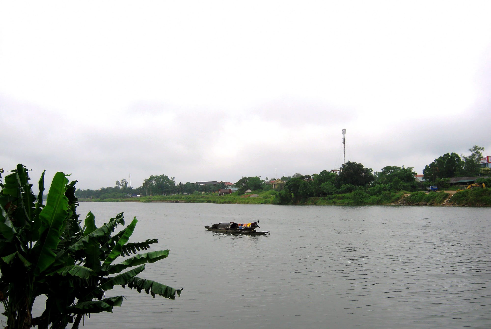
A small boat on a wide grey-green river, with low houses, palms and trees along the far bank under a pale sky

Hue & the North Central Coast, Vietnam

Dong Ha

The Hiếu River where it passes the market in Dong Ha. (Bùi Thụy Đào Nguyên / Wikimedia Commons · CC BY-SA 3.0)

A small city on the Hiếu River in central Vietnam, where Highway 1 meets Highway 9, the road running west to the Lao border. Rebuilt after the fighting that destroyed much of Quảng Trị in the early 1970s, it is a market and transport town and the nearest base for the sites of the former demilitarised zone.

Neighbourhoods

  • The market quarter
    • Best for food
    • Local life
    • Markets

    The blocks beside the Hiếu River around the town's main market, the busiest part of Dong Ha. Produce, fish, fabric and household goods are sold from early morning, and the surrounding lanes are full of noodle stalls, pharmacies and motorbike shops.

    Open in Maps
  • The Highway 1 corridor
    • Close to transport
    • Hotels
    • Arrivals and departures

    The wide through-road that carries north–south traffic past hotels, filling stations, banks and restaurants set up for travellers and lorry drivers. It is convenient and noisy, and most of the town's accommodation is on or just off it.

    Open in Maps
  • The Highway 9 approach
    • Quiet and residential
    • Onward travel to Laos

    The western side of town, where the road towards Khe Sanh and the Lao Bảo border crossing begins. Warehouses, transport yards and newer housing line the route, and buses for Laos and the western districts leave from this side.

    Open in Maps
  • The riverside and the parks
    • Evening walks
    • Quiet and residential

    The embankment along the Hiếu and the squares and public gardens behind it, where people gather in the cool of the evening. It is mostly residential, with cafés facing the water and a bridge across to the northern bank.

    Open in Maps

Things to do

In the town

  • Hiếu Riverattraction

    The river that runs through the town to the Cửa Việt estuary, with an embankment walk, fishing boats and cafés along its banks.

    Open in Maps
  • Dong Ha marketmarket

    The main covered market by the river, supplying the town and the surrounding districts with produce, seafood and dry goods.

    Open in Maps

Short trips — the former demilitarised zone

  • Hiền Lương Bridgelandmark

    The bridge over the Bến Hải River at the 17th parallel, which carried Highway 1 across the line dividing Vietnam between 1954 and 1975, now a memorial site with its flag tower.

    Open in Maps
  • Vịnh Mốc tunnelsattraction

    A three-level tunnel system dug from 1966 into a coastal hillside, where a village lived some 30 metres underground through years of bombing, with wells, meeting rooms and chambers for families.

    Open in Maps
  • Khe Sanh Combat Baselandmark

    The former American base in the hills near the Lao border, site of a long siege in 1968, kept as a museum with aircraft and bunkers on the old airstrip.

    Open in Maps
  • Quảng Trị Citadellandmark

    The brick fortress of the old provincial capital, destroyed in a battle of eighty-one days in 1972 and preserved as a memorial with a museum and monument.

    Open in Maps
  • Trường Sơn National Martyrs' Cemeterylandmark

    The largest war cemetery in Vietnam, laid out over hills near the head of the Bến Hải with more than ten thousand graves of soldiers who died on the Trường Sơn supply routes.

    Open in Maps

Short trips — coast and mountains

  • Cửa Tùngbeach

    A beach and fishing town where the Bến Hải reaches the sea, north-east of the town and close to the Vịnh Mốc tunnels.

    Open in Maps
  • Cồn Cỏattraction

    A small island 27 km off the Quảng Trị coast, heavily fought over during the war and now open to visitors by boat in calm weather.

    Open in Maps
  • Lao Bảoattraction

    The last Vietnamese town on Highway 9, a place of about thirty thousand people with a border trade zone and market, on the route to Savannakhet in Laos.

    Open in Maps
  • Đakrông Bridgelandmark

    A suspension bridge over the Đakrông River where Highway 9 meets the mountain road south, in Bru-Vân Kiều country.

    Open in Maps

Seasonal events

  • TếtJanuary or February

    The lunar new year, when the market empties for several days, families visit graves and the town's streets are hung with decorations.

  • War memorial daysApril and July

    The anniversary of the end of the war in April and the day for war invalids and martyrs in July bring ceremonies, veterans and school groups to the province's cemeteries and memorials.

  • The flood seasonSeptember to December

    Heavy rain and typhoons raise the Hiếu and Thạch Hãn rivers, and flooding of low-lying streets and roads is a regular part of the autumn.

Eat and drink

Long-standing places and food districts in Dong Ha. Hours, ratings and directions come from your maps app, always current.

Quảng Trị classics

  • Cháo bột kitchensneighborhood

    The province's signature dish is a thick soup of hand-rolled rice noodles with fish or duck, sharp with pepper and chilli, eaten at small shops around the town.

    Open in Maps
  • Bánh ướt and bánh lọc stallsneighborhood

    Steamed rice sheets rolled with pork and herbs, and translucent tapioca dumplings filled with shrimp, sold at breakfast stalls and roadside stands.

    Open in Maps

Markets and street food

  • Dong Ha marketmarket

    The riverside market, where seafood from Cửa Việt, mountain vegetables and dry goods are sold, with noodle and chè stalls inside and around it.

    Open in Maps
  • The riverside cafés and beer tablesneighborhood

    Cafés along the embankment serve strong iced coffee during the day and draught beer with grilled seafood after dark.

    Open in Maps

Experience Dong Ha

History

The Hiếu River mouth has long been a crossing point on the routes between the coastal plain and the passes into what is now Laos. The area lay in Cham territory before it passed to Đại Việt in 1306, and Quảng Trị remained a frontier region, poor and fought over, lying just south of the Gianh River line that divided the Trịnh and Nguyễn domains in the seventeenth century. Under French rule Dong Ha grew as a small market settlement at the junction of the coastal road and the new Route 9 west to Savannakhet, a role it has never lost.

Partition in 1954 put the dividing line at the Bến Hải River, about 20 km north of the town, with a demilitarised strip either side of it. That line made the district a front. Through the 1960s the area held military bases and airstrips, and the surrounding hills, coast and fields were bombed, shelled and defoliated. In 1972 fighting across the province, including the eighty-one-day battle for the citadel at Quảng Trị town, destroyed nearly everything built here; much of the population had fled, and the ruins were left to be cleared afterwards.

Reconstruction began after 1975 and was slow in a province with poor soil, ruined infrastructure and fields full of unexploded ordnance. When Quảng Trị was re-established as a separate province in 1989, the largely rebuilt Dong Ha became its capital, and it was recognised as a city in 2009. Growth since has come from transport and trade along Highway 1 and the corridor to Laos, and from visitors to the war sites. In 2025 administrative reform merged Quảng Bình into the province, and Dong Ha ceased to be its capital.

Culture & Customs

Public culture here is bound up with remembrance. The province holds a great number of cemeteries and memorials, among them the Trường Sơn martyrs' cemetery, the largest in the country, and the days set aside for veterans and the war dead are marked seriously, with incense, ceremonies and school visits. Families with missing relatives still search for graves, and the work of clearing bombs from farmland is a normal part of local news. That weight sits alongside an everyday manner that is plain and practical rather than solemn.

The people of Quảng Trị have a reputation across Vietnam for toughness and frugality, shaped by thin soil, hot dry winds and repeated disasters, and their central accent is sharp and hard for other Vietnamese to follow. Ancestor worship is universal, village communal houses hold their festivals after Tết, and Catholic parishes have a long presence in the province, with La Vang a major pilgrimage site for Vietnamese Catholics.

West of the town the population shifts. The Bru-Vân Kiều and Tà Ôi peoples live in the mountains along Highway 9 and the Lao border, keeping their own languages, weaving and gong music, and the market towns on that road mix highland and lowland trade. Dong Ha itself, as a crossroads, is used to movement — lorry drivers, traders heading for Laos, and returning migrants — and has the informal, transactional feel of a town on a main road.

Daily Life

About 164,000 people lived in the city at the last count, in 2024. It was the provincial capital from 1989 until the reorganisation of 2025 and remains the commercial centre for a largely rural stretch of country. Offices, schools, the hospital and the market provide much of the steady work, and the rest of the economy follows the roads: haulage, warehousing, repair shops, fuel and hotels serving traffic on Highway 1 and the corridor west to the Lao border. Farming and fishing continue around the edges, with rice, pepper, cassava and rubber in the districts and boats working out of Cửa Việt.

Money from abroad matters here as much as in neighbouring provinces. Many households have relatives working in Hanoi, Ho Chi Minh City, Japan, Korea or Taiwan, and remittances pay for the new concrete houses that stand among older ones. Poverty is still above the national average, and the province's disability rate reflects decades of accidents with unexploded ordnance, though clearance programmes have reduced them substantially.

The day begins early, with the market at full pitch by six and offices open before eight, then slows through a long, hot afternoon. Evenings bring people out to the riverside embankment, the parks and the pavement beer tables, and to the cafés that serve very strong iced coffee. Autumn floods are expected, and households keep their ground floors clear and their documents high through the wet months.

Food

Quảng Trị cooking is straightforward, salty and strongly peppered, made for hot weather and hard work. The dish most associated with the province is cháo bột, a thick soup of short hand-rolled rice noodles cooked with duck or with small river and sea fish, heavy on black pepper, chilli and spring onion; it is eaten at any hour and is the thing people from elsewhere are told to try here.

The central repertoire of steamed and wrapped snacks appears everywhere: bánh lọc, tapioca parcels holding a shrimp and a piece of pork, steamed in banana leaf; bánh ướt, soft rice sheets rolled around pork and herbs; and bánh khoái, a small crisp pancake with a peanut sauce. Seafood comes in from Cửa Việt and Cửa Tùng — squid, anchovies, mackerel and clams — and the coastal villages make their own fish sauce and shrimp paste, sold in bottles at the market.

Beyond that the province is known for its pepper, grown in the red basalt soil of the western districts, and for the sesame and peanut sweets that turn up at Tết. Cà phê is taken thick, sweet and iced, draught beer is cheap and everywhere, and rice wine is poured at family meals and at the feasts that follow a death anniversary.

Planning tools

Budget

Dong Ha is cheap even by Vietnamese standards, with plain hotels aimed at travellers on Highway 1 and low restaurant prices. There is little to pay for in the town itself; the costs are transport and guiding to the DMZ sites, which are spread across the province, and the entrance fees at the tunnels, the citadel and Khe Sanh, which are small.

Daily Budget Midrange
USD 50–120 (the town's better hotels, restaurant meals, a car and guide for a day around the DMZ)
Daily Budget Shoestring
USD 20–35 (guesthouse, market and street food, local buses or a rented motorbike)

Sharing a car and guide for the day costs far less per person than a private trip, and cash is needed at rural sites and small kitchens.

Best Time to Visit

February to May is the most comfortable time, dry and mild before the summer heat. June to August is hot and often fiercely dry when the wind blows off the Lao mountains, which makes the exposed war sites hard going in the middle of the day. From September to December rain and floods are frequent and roads can be cut.

Suggested Number of Days

Most people stay one night, using the town as a base rather than a destination. Two or three days allow the sites north and west of the town and the coast at an easier pace, or a break in the journey to or from the Lao border.

First Visit
1 day
With Surroundings
2–3 days

Transportation

The town is small and flat, and motorbike taxis, ride-hailing apps and a few metered taxis cover it. Beyond it, the DMZ sites are spread over tens of kilometres along Highways 1 and 9, with no useful local bus service between them, so visitors hire a motorbike, a car with a driver or join a tour, often one running from Huế. Buses west to Lao Bảo and Savannakhet and north and south along Highway 1 leave from the town's stations.

Highway 1 through the town carries heavy lorry traffic at all hours, so take care crossing and avoid riding it after dark.

Airport & Station Connections

Dong Ha sits on Highway 1 and on the north–south railway, with a station in the centre; Huế is about 110 km south and Đồng Hới about 160 km north, each roughly two hours away by train or bus. The nearest airports are Phú Bài beyond Huế and Đồng Hới to the north, and an airport for the province is under construction. Buses to Laos run west along Highway 9 through Lao Bảo to Savannakhet.

Walkability

The centre is compact and level, and the market, riverside and most hotels are within fifteen or twenty minutes of each other on foot. Highway 1 and the wide junction roads are unpleasant to walk beside, with fast traffic and gaps in the pavement, and the heat limits walking in the middle of the day. Everything outside town needs transport.

Safety

The town is safe, with little crime affecting visitors. The serious local hazard is unexploded ordnance: Quảng Trị is among the most contaminated provinces in Vietnam, clearance teams still work in the fields, and visitors should stay on marked paths at war sites and never handle metal objects. Traffic on Highway 1 and autumn flooding are the other risks.

Only ride a motorbike if experienced and licensed, and always with a helmet; hold bags away from the road; drink bottled or filtered water; and check surf conditions before swimming. Check current official travel advice before travelling.

Climate

Hot, with a short dry season and a heavy wet one. Rain concentrates between September and December, when typhoons and river floods are common; spring and summer are dry, and the westerly wind off the mountains can push temperatures to the highest in the country.

Summer
very hot and dry, often 34–39°C, with little shade at the war sites
Winter
mild but wet and grey, about 18–23°C, with long spells of rain

Local Customs

Quảng Trị is a province of memorials and family graves, and the war sites are places of mourning as well as history. Quiet behaviour, covered shoulders and knees, and care around graves, incense and visiting families are expected, particularly at the cemeteries. In the town, life is early, modest and unhurried, and tipping is not expected.

Ask before photographing people at graves or memorials, never pose on monuments or in cemeteries, and stay on paths in fields that may still hold ordnance.

Common Payment Methods

The currency is the Vietnamese đồng. Hotels, larger restaurants and shops on Highway 1 take cards and QR-code payments, and ATMs are easy to find in the centre. Markets, drivers, small kitchens and rural entrance gates work in cash, and cash is essential for a day out to the DMZ sites.