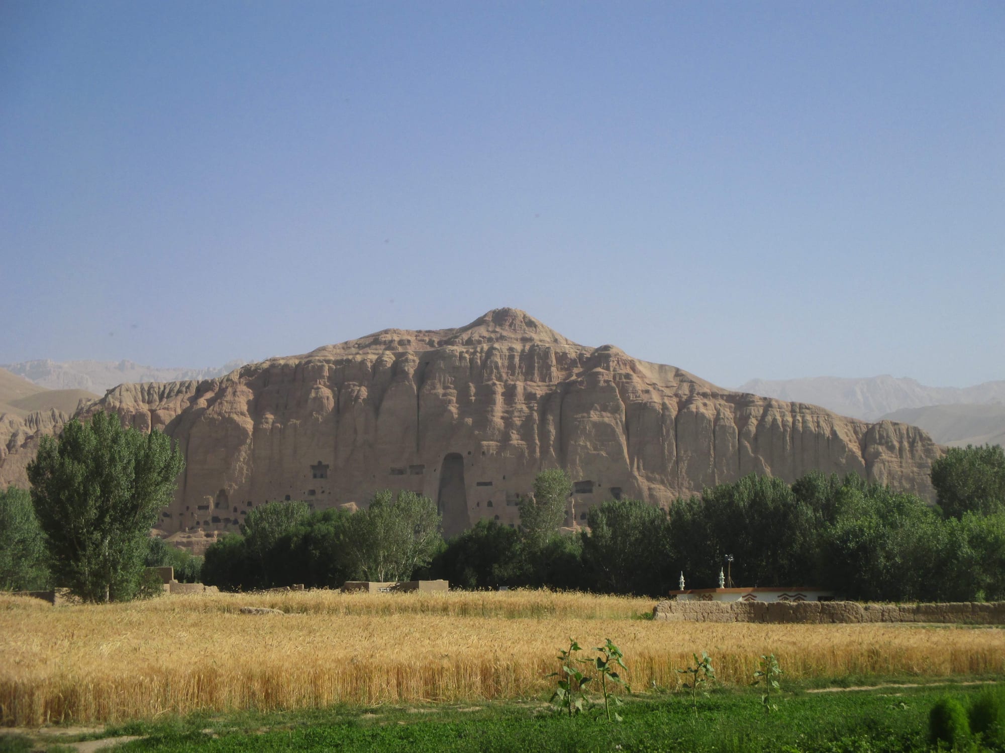
A ripe wheat field and poplar trees below a long sandstone cliff with caves and a tall empty niche

Afghanistan

Kabul & the East

Wheat fields below the cliff of the Bamyan valley, with the empty niche of one of the destroyed Buddhas. (Monikajoannah / Wikimedia Commons · CC BY-SA 4.0)

The capital and the provinces around it, from the Kabul basin and the Shomali plain west to the Hazara highlands of Bamyan and east down the Kabul river to Jalalabad, the Pakistani border and the forested mountains of Nuristan — the political heart of the country. This page is written to explain the region, not to encourage travel.

Explore Kabul & the East

History

The Kabul valley sits where routes from India, Central Asia and Iran converge. In the Kushan era, in the first centuries AD, it lay near the heart of a Buddhist empire: Kapisa, at today's Bagram in Parwan, was a royal city, where archaeologists found the Begram hoard of Indian ivories, Roman glass and Chinese lacquer, and Mes Aynak in Logar was a copper-mining town with large monasteries. In Bamyan, pilgrims and merchants passed a valley where monks carved many caves and two giant Buddhas into the cliff in the 6th and early 7th centuries. The Chinese monk Xuanzang described both in the 7th century. Genghis Khan's army destroyed Bamyan's citadel, Shahr-e Gholghola, in 1221.

Babur, founder of the Mughal empire, took Kabul in 1504 and ruled from it before conquering India; he is buried in his garden here. In 1776 Timur Shah Durrani moved the Afghan capital from Kandahar to Kabul. The First Anglo-Afghan War ended in disaster in 1842, when the retreating British force was destroyed between Kabul and Jalalabad at Gandamak. In the 1890s Emir Abdur Rahman Khan conquered Kafiristan and converted its people to Islam, renaming it Nuristan, "land of light".

The 20th century made Kabul a modernising capital, with the Darul Aman Palace built for King Amanullah in the 1920s, then the stage of the 1978 coup and the Soviet occupation. The Panjshir, under Ahmad Shah Massoud, resisted repeated Soviet offensives. Kabul was heavily shelled in the civil war of 1992–96, the Taliban destroyed the Bamyan Buddhas in 2001, and Massoud was killed two days before the September 11 attacks. Kabul fell to the Taliban in August 2021 amid the chaotic evacuation from its airport, and weeks later the Taliban claimed control of the Panjshir, where a resistance front had formed.

Culture & Customs

The region mixes the country's peoples more than any other. Kabul is a Dari-speaking city that has drawn migrants from every province. The Shomali plain, Parwan, Kapisa and the Panjshir are mainly Tajik; Logar, Wardak, Nangarhar, Laghman and Kunar are mainly Pashtun, with Pashai speakers in the eastern valleys. Bamyan is the centre of the Hazarajat, the homeland of the Shia Hazara people, whose Persian dialect is called Hazaragi and who have faced long histories of persecution.

Nuristan is a world apart: its peoples speak their own Nuristani languages, and before their conversion to Islam in the 1890s they carved wooden figures of gods and ancestors in styles quite unlike the rest of the country.

Kabul was long the centre of Afghan music — the rubab lute, the tabla and the city's classical singers — and of cinema, television and fashion; much of this has been silenced or driven abroad since 2021. Kite-flying and kite-fighting are Kabul passions, and the pottery of Istalif, a village on the Shomali plain with turquoise-glazed bowls, is a well-known craft. In the east, Pashtun hujras, the village guest houses, keep the traditions of hospitality and the jirga, the council of elders.

Daily Life

Kabul, with several million people, is by far the country's largest city and has grown enormously since 2001, spreading up the hillsides in unplanned mud-brick and concrete settlements. Jalalabad, with a few hundred thousand, is the second city of the region; Charikar, Bamyan town, Mahmud-i-Raqi, Pul-e Alam, Maidan Shar, Asadabad, Mehtarlam and Bazarak are small provincial centres.

Kabul lives on government, trade and services. The east is agricultural: Nangarhar grows citrus and sugar cane in its warm valley, the Shomali plain has orchards and vineyards, and Kunar and Nuristan rely on forests, terraced fields and herds. The Torkham crossing makes Jalalabad a trading town, and the Panjshir is known for its emeralds.

Days in Kabul begin with traffic, fresh bread and tea; bazaars fill by mid-morning, and Fridays are for prayer and family gatherings. The city has absorbed returnees and displaced people from across the country, and unemployment and poverty are severe. The closure of secondary schools and universities to girls and the restrictions on women's work have been felt most sharply here, in a capital where many women worked as teachers, doctors and civil servants.

Food

Kabul gives the national dish its name: Kabuli palaw, rice steamed with lamb stock and topped with carrots, raisins and nuts, is the centre of any feast in the region. The capital's street food includes bolani, stuffed flatbreads, and kebabs grilled over charcoal. In summer, sheer yakh, a traditional ice cream, is sold across the city.

At Nowruz Kabul families have prepared haft mewa, seven dried fruits and nuts soaked in water, and samanak, a slow-cooked pudding of sprouted wheat. Aushak, leek dumplings with yoghurt and meat sauce, is a Kabul favourite for guests.

The east has its own flavours. Jalalabad is known for its oranges and sugar cane, and its kebab houses serve the chapli kebab, a speciality of eastern Afghanistan. In Bamyan the diet is plainer — bread, potatoes, dairy and qurut, dried yoghurt. Green and black tea are drunk throughout; alcohol is prohibited.

Attractions & Natural Wonders

Kabul keeps sights despite decades of war: the Bagh-e Babur, a terraced Mughal garden with the emperor's tomb, the National Museum, whose surviving treasures were partly saved by staff who hid them, the long-ruined and now restored Darul Aman Palace, the Shah-Do Shamshira mosque by the river, the Bala Hissar fortress walls above the city, and the Qargha reservoir and Paghman hills to the west. North of the capital lie the vineyards of the Shomali plain and the potters of Istalif.

The Bamyan valley is the region's greatest monument: a long sandstone cliff with the two empty niches of the Buddhas, about 55 and 38 metres tall, and hundreds of caves, some with traces of painting, facing the ruins of Shahr-e Gholghola and the red fortress of Shahr-e Zuhak. West of Bamyan, the Band-e Amir lakes lie in a dry plateau, their travertine walls holding back water of deep blue.

North-east of Kabul, the Panjshir valley runs deep into the Hindu Kush along its river, with Massoud's tomb at Bazarak. To the east, Jalalabad sits among orange groves, with the Buddhist site of Hadda nearby, the Spin Ghar range and Tora Bora to the south, and the road to Torkham and the Khyber Pass beyond. North of Jalalabad the Kunar valley leads into the Nuristan mountains, a land of forests, rushing rivers and high peaks.

Cities in Kabul & the East

Planning basics

Budget

Kabul is the most expensive place in the country, especially for the secure guesthouses and hotels that foreigners have tended to use, but still cheap by world standards; everything is cash in afghanis changed from US dollars. Bamyan has simple guesthouses aimed at domestic visitors. Nuristan, Kunar and the Panjshir have almost no accommodation for outsiders.

Daily Budget Midrange
USD 40–100 (guarded hotel in Kabul, hired car with driver)
Daily Budget Shoestring
USD 20–35 (basic guesthouse, bazaar food, shared taxis)

Change only what is needed and keep small notes.

Safety

Most governments advise against all travel to Afghanistan, and that applies fully here. Kabul has suffered many of the country's deadliest bombings, including attacks on schools, mosques and the airport, and the Islamic State affiliate has been active in Kabul and Nangarhar. Kidnapping and wrongful detention of foreigners are real risks, with no consular help. The border provinces of Kunar and Nuristan and the Panjshir have seen armed conflict, and landmines and unexploded ordnance remain widespread.

Anyone still considering a visit should read their government's full advisory, avoid crowds, government sites and border areas, and never step off used paths. Check current official travel advice before travelling.

Climate

Kabul lies at about 1,800 metres, with warm, dry summers and cold, snowy winters. Bamyan, higher still, is cold for much of the year and snowbound in winter. Jalalabad, far lower on the Kabul river, is the contrast: hot in summer and mild in winter, when Kabulis have long gone down to escape the cold. Nuristan and Kunar catch more rain than the rest of the region.

Summer
around 30–33°C in Kabul with cool nights; above 40°C in Jalalabad; mild in Bamyan
Winter
below freezing and snowy in Kabul and Bamyan; mild in Jalalabad, around 5–18°C

Transportation

Kabul's airport is the country's main gateway, with domestic flights to the other big cities. Roads fan out from the capital: north to Charikar and the Salang tunnel, east through the Kabul river gorges to Jalalabad and the Torkham crossing into Pakistan, and west over high passes to Bamyan, a full day's drive. The Panjshir is reached from the Shomali plain; Kunar and Nuristan by rough roads north from Jalalabad.

Mountain roads to Bamyan and the Panjshir can close in winter; allow spare days and travel only in daylight.

Best Time to Visit

April to June and September to October for Kabul and Bamyan, when days are mild and the roads over the passes are open; Band-e Amir is at its most colourful from late spring to early autumn. Jalalabad is at its best in winter and early spring, when the orange trees are in fruit or blossom.