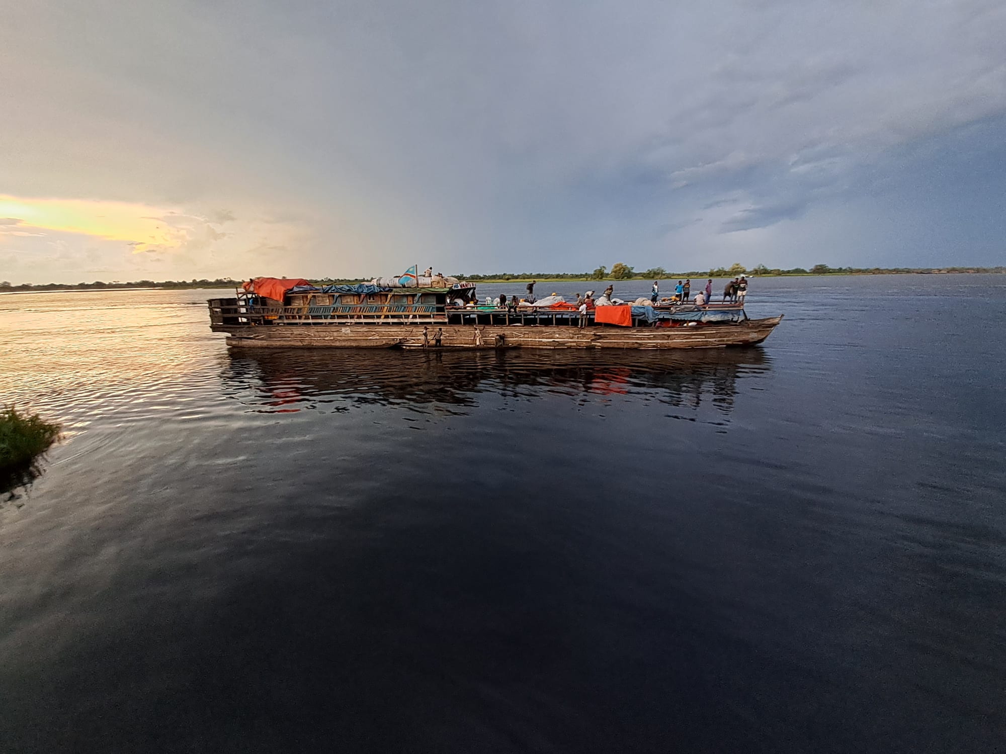
A loaded wooden river boat with passengers on deck crossing a wide, calm river under a grey evening sky

Democratic Republic of the Congo

Mbandaka & the Northwest

A passenger and cargo boat on the Congo River at Mbandaka, capital of Équateur province. (Coginta / Wikimedia Commons · CC BY-SA 4.0)

The DR Congo's north-western rainforest and river country, from Mbandaka on the equator around the great bend of the Congo to the Ubangi borderlands and Mobutu's palace town of Gbadolite — a Lingala- and Mongo-speaking land of rivers, swamp forest and the Salonga reserve, the largest in Africa's rainforest.

Explore Mbandaka & the Northwest

History

The forests of the central basin have been home for thousands of years to Batwa forest peoples and later to Bantu-speaking farmers and fishers, above all the Mongo groups, who spread along the rivers. Trade in canoes along the Congo, Ubangi and their tributaries linked villages across hundreds of kilometres long before Europeans arrived.

In 1883 Henry Morton Stanley set up a post at the equator that became Coquilhatville, today's Mbandaka. Under King Leopold II's Congo Free State the region suffered the worst of the rubber regime: the Anglo-Belgian India Rubber Company, or ABIR, based at Basankusu, and the state's own agents forced villages to collect wild rubber, with hostage-taking, mutilation and killing used against those who fell short. Missionary photographs and reports of these abuses helped build the international campaign that ended Leopold's rule in 1908. Under Belgian rule the Ubangi became a region of coffee and palm-oil plantations.

Mobutu Sese Seko was born in Lisala in 1930, and during his rule he lavished money on his home area, building palaces and an airport at Gbadolite and a hydroelectric dam on the nearby Ubangi. After his fall in 1997, Jean-Pierre Bemba's Movement for the Liberation of Congo, backed by Uganda, made the north-west its base during the Second Congo War. The province of Équateur was split into five in 2015.

Culture & Customs

Lingala grew up as a trade language along this stretch of river before spreading downstream to Kinshasa, and it remains the common tongue of the region. The Mongo peoples, including the Nkundo, dominate the south, while the Ngbandi, Mobutu's people, and the Ngbaka and Ngombe live in the Ubangi and Mongala provinces. Batwa communities around Lake Tumba and in the forests face discrimination and insecure land rights.

Life follows the rivers: fishing camps move with the water level, pirogue races and river trade structure the year, and the arrival of a barge turns a waterfront into a market. Oral literature is rich, and the Mongo keep the epic of Lianja, a hero's tale.

Catholic and Protestant missions have been active since the late 19th century, and churches remain central to schooling and health care. Customary chiefs, clan elders and the obligations of the extended family carry great weight in villages.

Daily Life

Mbandaka, the provincial capital of Équateur, and Gemena, capital of Sud-Ubangi, are the main cities. Gbadolite, Lisala, Bumba and Boende are smaller administrative and trading towns, and most people live in villages strung along rivers and forest roads.

The economy is built on fishing, subsistence farming of cassava, maize and plantain, palm oil, and small trade carried by boat. Timber companies work concessions in the forest, and the old coffee, rubber and palm plantations of the colonial era have largely declined. Bumba and Lisala are river trading towns, and Yambuku, near Bumba, gave its name to the first recorded Ebola outbreak in 1976.

A typical day starts at dawn on the riverbank, where fishers land their catch and women sell smoked fish and cassava. Electricity is scarce and often provided by generators or solar panels, and phone coverage has only recently reached many villages. Health, schooling and the lack of roads are the constant issues.

Food

River fish is the centre of the table — catfish, tilapia and many local species, eaten fresh, grilled, or smoked over wood fires for sale downstream. Fish is often wrapped in leaves with onions, tomatoes and chilli and cooked as liboke. Cassava is eaten as chikwangue loaves or fufu, and pondu, stewed cassava leaves, accompanies most meals.

Forest foods matter more here than elsewhere: mushrooms, wild leaves, honey, caterpillars in season and bushmeat, although hunting of protected species is illegal. Plantains, known in Lingala as makemba, are boiled or fried, and palm oil colours sauces orange-red.

Palm wine is tapped across the region, and local maize or cassava spirits are distilled in villages. Bottled beer arrives by boat from Kinshasa, and in Mbandaka's bars it accompanies grilled fish and music late into the evening.

Attractions & Natural Wonders

Mbandaka sits almost exactly on the equator, where the Ruki river joins the Congo, with a waterfront busy with barges and pirogues. Just outside the city, the Eala botanical garden, founded in the colonial era, preserves a large collection of tropical plants. To the south, Lake Tumba spreads through swamp forest, part of a wetland system that also holds bonobos.

Upstream, the Congo river's bend carries the river in a great arc north of the equator through Bumba and Lisala, a landscape of wide water, forested islands and riverbank villages best seen from a barge. In the far north, Gbadolite keeps the ruins of Mobutu's palaces, including the pagoda-roofed residence at Kawele, and an airport runway once used by chartered Concordes; the Ubangi river forms the border with the Central African Republic and the Republic of the Congo.

Salonga National Park, split into two blocks in the heart of the central basin, is the largest tropical rainforest reserve in Africa and a UNESCO World Heritage Site. It shelters bonobos, forest elephants and the Congo peafowl, and most of it is accessible only by river, on expeditions arranged with the park.

Cities in Mbandaka & the Northwest

Planning basics

Budget

There is no tourist economy here. Mbandaka and Gbadolite have a few basic hotels priced in US dollars, food in markets is cheap, and the real costs are flights, boat charters, fuel and permits. Visiting Salonga means an expensive expedition organised with the park's managers.

Daily Budget Midrange
USD 100–250 (basic hotel, meals, local transport), with boat charters and flights on top
Daily Budget Shoestring
Not realistically applicable for visitors

Carry clean US dollar notes and enough cash for the whole trip; there are few reliable cash machines outside Mbandaka.

Safety

The northwest is far from the eastern war and generally calmer, but policing and health services are thin. Overcrowded boats capsize on the rivers with heavy loss of life, Ebola outbreaks have hit Équateur several times, including around Mbandaka, and instability in the neighbouring Central African Republic affects the Ubangi border. Petty crime and demands from officials at checkpoints are common.

Most governments advise caution throughout the DR Congo; travel here should be organised with a reliable local contact, with evacuation and medical cover arranged. Check current official travel advice before travelling.

Climate

Fully equatorial around Mbandaka and in the central forest: hot, humid and wet all year, with rain peaks in spring and autumn and no true dry season. Further north in the Ubangi provinces a drier season appears from about December to February, and the savanna margins around Gbadolite are slightly less humid.

Summer
hot and humid, 22–32°C, frequent heavy downpours
Winter
much the same near the equator; a drier spell from December to February in the far north

Transportation

Mbandaka, Gemena and Gbadolite have airports with domestic flights, mostly to Kinshasa. The Congo river is the main highway: barges and boats link Kinshasa, Mbandaka, Lisala and Bumba, taking days or weeks and running without timetables. Roads are mostly dirt tracks that become impassable in the rains; most of Salonga is accessible only by river.

River boats are often overloaded and accidents are common; fly where possible and never board a vessel that looks overcrowded.

Best Time to Visit

There is no strong season near the equator. River levels matter more: high water after the rains makes navigation easier on the smaller rivers, while low water can strand barges. The drier months in the north, around December to February, are easiest for road travel around Gbadolite and Gemena.