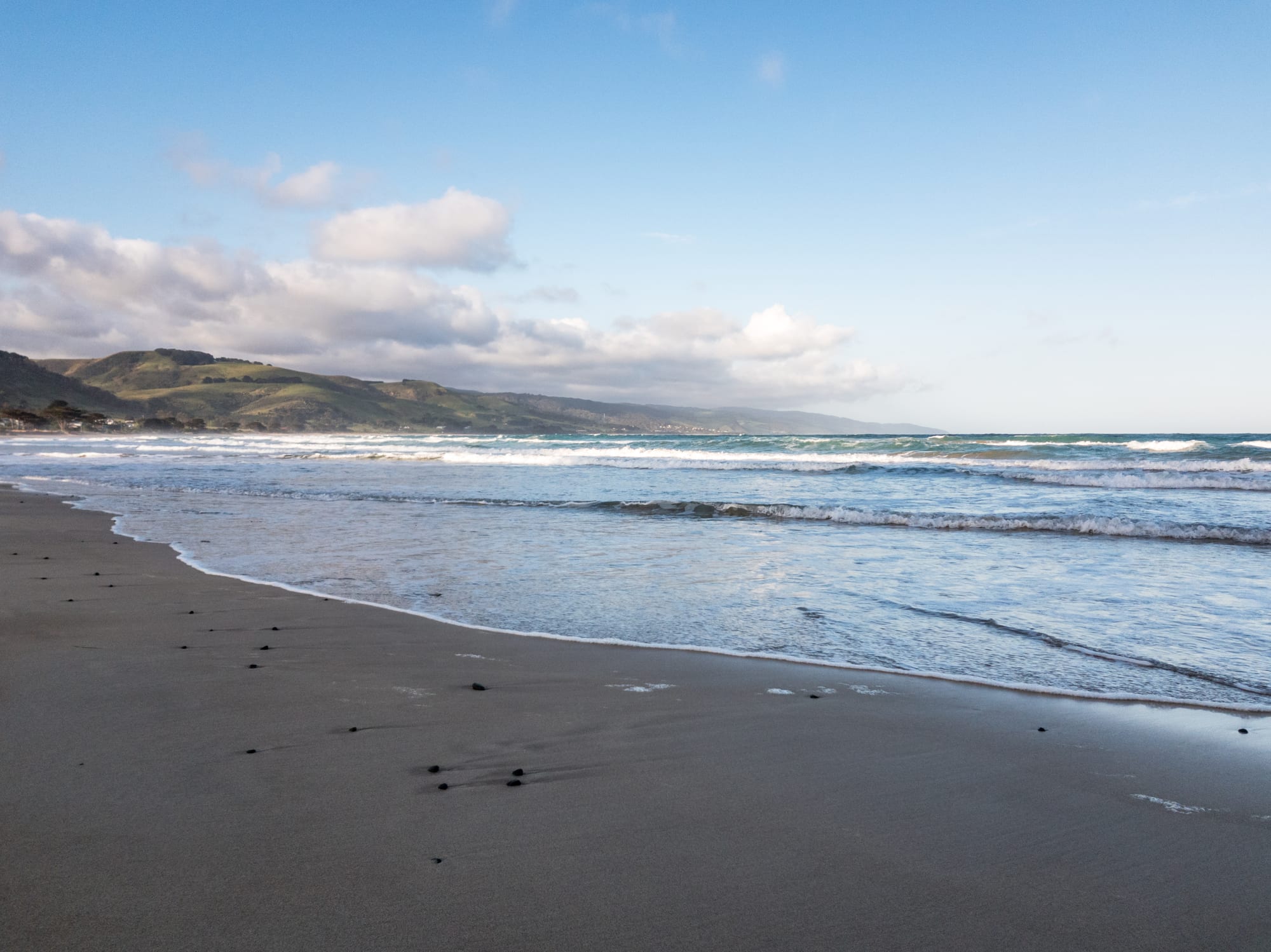
A wide sandy beach with rolling surf curving towards green coastal hills under a partly cloudy sky

Melbourne & Victoria, Australia

Apollo Bay

The beach at Apollo Bay, with the green slopes of the Otway Ranges beyond. (Dietmar Rabich / Wikimedia Commons · CC BY-SA 4.0)

A fishing and holiday town on the Great Ocean Road, set between the surf of Bass Strait and the forested slopes of the Otway Ranges about 190 kilometres from Melbourne. Timber and crayfishing built it, the coast road brought the visitors, and it is now the start of the Great Ocean Walk and a base for the Otways' waterfalls and rainforest.

Neighbourhoods

  • The main street and foreshore
    • First-time visitors
    • Best for food
    • Close to the beach

    The Great Ocean Road runs through the middle of town as its main street, with shops, cafés, pubs and galleries on one side and a grassy foreshore reserve, caravan park and the beach on the other. Almost everything is within a few minutes' walk.

    Open in Maps
  • The harbour
    • Boat trips
    • Local life

    A built harbour at the southern end of the beach, protected by a breakwater, where the fishing fleet ties up and the catch is landed and sold. There is a walk out along the wall, a boat ramp and a view back over the bay to the hills.

    Open in Maps
  • Marengo
    • Quiet and residential
    • Beaches

    A small settlement a couple of kilometres south, with a sheltered beach, a caravan park and a reef offshore. It is quieter than the town and the coast road begins to climb towards Cape Otway just beyond it.

    Open in Maps
  • Skenes Creek
    • Quiet and residential
    • Beaches

    A handful of houses and holiday units around a creek mouth about six kilometres north-east, where the inland road from Colac comes down the ridge to the coast. The beach is broad and usually empty outside the holidays.

    Open in Maps

Things to do

Walks and the coast road

  • Great Ocean Walktrail

    A long-distance coastal track of about 100 kilometres that begins in the town and runs west past Cape Otway to the limestone stacks beyond, walked in sections or end to end.

    Open in Maps
  • Great Ocean Roadattraction

    The coastal road built between 1919 and 1932 by returned servicemen as a war memorial, which reaches the town by a cliff-edge run from Lorne and climbs into the forest on the way west.

    Open in Maps

Short trips into the Otways

  • Great Otway National Parkpark

    Created in 2005 from earlier reserves, a park of tall eucalypt forest, tree-fern gullies, cool temperate rainforest, waterfalls and heathland behind and beside the town.

    Open in Maps
  • Cape Otway Lighthouselandmark

    A lighthouse first lit in 1848 on the cape where Bass Strait meets the Southern Ocean, the oldest surviving lighthouse on the Australian mainland, with keepers' cottages and a telegraph station around it.

    Open in Maps
  • Hopetoun Fallsattraction

    A single drop of about 18 metres on the Aire River, in dense tree-fern forest in the Otway Ranges, reached by a steep stepped path from a car park above it.

    Open in Maps
  • Otway Flyattraction

    A steel walkway 600 metres long suspended as much as 47 metres above the floor of mountain ash and myrtle beech forest in the hills inland, with zip-line tours as well.

    Open in Maps

Short trips along the coast

  • Lorneattraction

    The larger resort town about 45 kilometres back along the coast, with a pier, a swimming beach and waterfall walks in the forest behind it.

    Open in Maps
  • Twelve Apostleslandmark

    The limestone stacks standing off the cliffs west of Cape Otway, the best-known sight on the Great Ocean Road, about 90 kilometres from the town by road.

    Open in Maps
  • Port Campbell National Parkpark

    A narrow coastal park of cliffs, gorges and sea stacks west along the shipwreck coast, taking in Loch Ard Gorge and the arches and blowholes near Port Campbell.

    Open in Maps

Seasonal events

  • Winter Wildwinter

    An annual winter festival in the town, one of the events that keep the quiet months busy once the holiday crowds have gone.

  • Great Ocean Road Running Festivallate autumn

    A weekend of road races along the coast, held since 2005 and built around a 44-kilometre marathon from Lorne to Apollo Bay, which fills the town with runners and closes stretches of the road.

Eat and drink

Long-standing places and food districts in Apollo Bay. Hours, ratings and directions come from your maps app, always current.

Off the boats

  • Apollo Bay Fishermen's Co-opmarket

    The fishing co-operative at the harbour, where the fleet's catch is sold straight off the boats, including southern rock lobster in season.

    Open in Maps
  • Fish and chips on the main streetrestaurant

    Several takeaway shops along the Great Ocean Road fry the local catch, eaten on the foreshore grass with the gulls in attendance.

    Open in Maps

Markets, cafés and pubs

  • Apollo Bay Foreshore Marketmarket

    A weekend market on the grass beside the beach, with Otway produce, cheese, bread, berries, coffee and craft stalls.

    Open in Maps
  • Cafés and pubs on the Great Ocean Roadneighborhood

    The main street holds bakeries, cafés, a brewery and two large hotels, busy with walkers and drivers breaking the journey along the coast.

    Open in Maps

Experience Apollo Bay

History

The Otway coast is the country of the Gadubanud people, who lived between the rainforest and the sea and whose name for this place was Krambruk. Sealers and whalers worked the coast from the early 19th century, and the bay was named after the Apollo, the vessel Captain Loutit sheltered here from a storm in 1845; the township was called Middleton and then Krambruk before it became Apollo Bay in 1898.

The town that grew on the beach lived on two industries. Timber-getters cut the great eucalypt forests behind it from the 1850s, hauling logs to jetties and later to narrow-gauge tramways, and a narrow-gauge railway from Colac reached Beech Forest in 1902 and Crowes beyond it, carrying timber and potatoes until it closed in 1962. At the same time a fishing fleet built up in the bay, working crayfish, abalone and scale fish, and a harbour was constructed to shelter it. Until well into the 20th century the sea and a rough inland track were the only ways in.

The Great Ocean Road changed that. Cut into the cliffs between 1919 and 1932 by returned servicemen as a memorial to those killed in the First World War, it linked the coastal settlements to Geelong and brought holidaymakers, first by the busload and then by car. Sawmilling faded through the later 20th century and native-forest logging in the Otways has since been wound back, and the reserves behind the town were brought together as the Great Otway National Park in 2005. Tourism, fishing and farming now carry the town, and the Great Ocean Walk, opened in 2006, starts on its foreshore.

Culture & Customs

Apollo Bay keeps the mixed character of a working fishing port and a holiday town. Boats still go out from the harbour, the surf life-saving club patrols the beach through summer, and the football and netball club is a fixture of winter weekends, while the population multiplies in January and empties again by February. Residents talk about the seasons in terms of visitors as much as weather.

The hinterland has drawn artists, growers and people after a quieter life since the 1970s, and the town has galleries, craft stalls at the weekend market and festivals of its own, among them WordFest and the winter event Winter Wild. The Great Ocean Walk brought a walking culture with it, and the long-distance runners' festival along the coast in late autumn is now part of the calendar too.

Conservation shapes local identity. The end of native-forest logging and the creation of the national park were argued over for years, and the forests, waterfalls and wildlife are now the town's livelihood as well as its backdrop. Koalas, seals and glow-worms are treated as assets to be looked after rather than displayed. Gadubanud connection to the country is acknowledged in place names and park interpretation, and the coastal middens and the forest are understood locally as a cultural landscape as much as a scenic one.

Daily Life

About 1,800 people live in Apollo Bay, and several times that number are in town on a hot weekend in January. It belongs to the Colac Otway Shire, and the administrative centre, the hospital and the larger supermarkets are at Colac, about 70 kilometres inland over the ranges. The town has a primary and secondary college, a small medical clinic and an ambulance and fire brigade largely staffed by volunteers.

Work is tourism, hospitality, fishing, building and farming. Beef and dairy cattle graze the cleared hills behind the coast, the fleet lands lobster and fish, and accommodation, cafés and tours employ most of the rest, much of it seasonally. A large share of houses are holiday homes or short-stay rentals, which has pushed prices well beyond local wages and made housing for workers a constant difficulty.

Daily life is quiet and weather-driven. Winter is a small-town routine of school, sport and the pub, with tradespeople working on empty holiday houses; summer is long days of full car parks, queues at the bakery and a foreshore covered in tents. Bushfire preparation is an annual discipline, storms and landslips occasionally close the road in both directions and cut the town off, and mobile and internet coverage remain a live local complaint.

Food

Seafood is the point. The fleet works southern rock lobster, known here as crayfish, along with abalone, flathead, whiting and squid, and the co-operative at the harbour sells it within hours of landing. Fish and chips eaten on the foreshore is the town's standard meal, and restaurants on the main street put whatever the boats have brought in on the board.

Around it is the produce of the Otways. The high rainfall behind the coast suits dairying, and the region's milk, cheese and ice cream are sold in the town; berries, apples and potatoes come from the hills; and beef is raised on the cleared ridges. The weekend foreshore market brings growers, bakers and cheese makers together, and the bakeries do a steady trade in meat pies and pastries with drivers on the coast road.

Otherwise the food is that of a small Australian coastal town, done reasonably well because the visitor season demands it — pub counter meals of steak, parma and schnitzel, pizza, burgers, a brewery on the main street, ice cream on the foreshore, and cafés serving flat whites, long blacks and brunch dishes from mid-morning. Victorian wines from the Otway hinterland and further afield fill the wine lists, and cool-climate pinot noir and chardonnay from the state's south suit the local fish.

Planning tools

Budget

Costs are seasonal. From late December to the end of January, and over Easter and long weekends, rooms and holiday houses are scarce and dear, with minimum stays common; in winter the same places are much cheaper. Camping and caravan sites are the cheapest beds in town. The walks, the beaches, the waterfalls and the lookouts cost nothing, and a car is the main other expense.

Daily Budget Midrange
USD 170–300 (motel room or holiday apartment, restaurant meals, park and attraction entry, a hire car)
Daily Budget Shoestring
USD 75–130 (campsite or hostel bed, self-catering, bakery and fish-shop meals, free walks and beaches)

Book months ahead for January and Easter, and fill the fuel tank before heading west, since stations are few between here and Port Campbell.

Best Time to Visit

December to March has the warmest, driest weather and the best swimming, with January the busiest month. Autumn is mild, green and much quieter, and the forests are at their best after rain. Winter is cool, wet and windy, with big southern swells and whales sometimes visible offshore between roughly June and September, and many places on shorter opening hours.

Suggested Number of Days

Two or three days suit the town, the beach and the nearest forest. Four or five allow the wider Otways, the lighthouse coast and the cliffs further west without long days of driving. Rain and road closures after storms can change plans at short notice.

First Visit
2–3 days
With Surroundings
4–5 days

Transportation

A car is the practical way to get here and around. V/Line coaches connect the town with Geelong and the coastal towns on a limited daily timetable, and tour buses run day trips from Melbourne. Within the town everything is walkable, and bicycles suit the flat foreshore, though the roads inland climb steeply. There are no trains on this coast.

Allow far more driving time than the distances suggest, since the coast road is narrow and winding with slow traffic, and avoid driving it at dusk when wildlife comes onto the road.

Airport & Station Connections

Most visitors drive from Melbourne, about 190 kilometres away. The coast route through Torquay and Lorne takes three to four hours and is the point of the journey; the inland route through Geelong, Colac and Skenes Creek is about half an hour quicker. Coaches run from Geelong, which has trains from Melbourne. The nearest airports are Avalon and Melbourne.

Walkability

The town is flat and linear, strung along the beach for a kilometre or so, and everything — shops, pubs, the foreshore, the harbour — is within an easy walk. A shared path runs along the foreshore, and the beach itself is walkable for kilometres at low tide. The hills behind the town rise sharply, so walks inland and up to the lookouts are steep.

Safety

The town is safe and quiet. The hazards are the coast and the road. The ocean beach has rips and cold water, and is patrolled only in the summer season. The Great Ocean Road is narrow, winding and busy with visitors, and tiredness, unfamiliar driving on the left and wildlife at dusk cause most accidents; landslips and fallen trees close it after heavy rain and storms. The Otway forests carry a bushfire risk in summer, and mobile coverage is patchy in the hills and along the walking tracks.

Swim between the flags when the beach is patrolled and stay out of the surf when it is not, take breaks on the drive, check road and fire conditions in summer and carry water and warm layers on forest walks. Check current official travel advice before travelling.

Climate

Cool, wet and maritime. The town faces Bass Strait and the weather comes off the sea, so it is windier and milder than inland Victoria and several degrees cooler than Melbourne on a hot day. The Otway Ranges immediately behind are among the wettest parts of the state, and rain falls all year with a winter peak. Seasons are reversed from the northern hemisphere, so summer runs from December to February and winter from June to August.

Summer
mild rather than hot — typically 13–22°C, with occasional northerly days above 30°C cut short by a cool change off the water
Winter
cool and wet — roughly 7–14°C, with frequent rain, strong south-westerlies and heavy swell on the coast

Local Customs

This is a small coastal town where dress is casual and people say hello in the street. Tipping is not expected. Alcohol is served in licensed pubs and restaurants and sold in bottle shops, with drinking restricted on the foreshore. The Otway coast is the country of the Gadubanud people, and the town was known as Krambruk before it took its present name. Wildlife is part of daily life, and feeding or crowding koalas, seals and kangaroos is both harmful and discouraged.

Keep to boardwalks and tracks in the rainforest gullies, take rubbish away from beaches and camp sites, do not light fires outside designated places, and slow down for wildlife on the roads.

Common Payment Methods

The currency is the Australian dollar. Cards and contactless payment are accepted in shops, cafés and the pubs, and there are ATMs on the main street. Some market stalls, honesty boxes at farm gates and small operators still prefer cash, and card networks occasionally drop out in the hills, so a little cash is worth carrying.