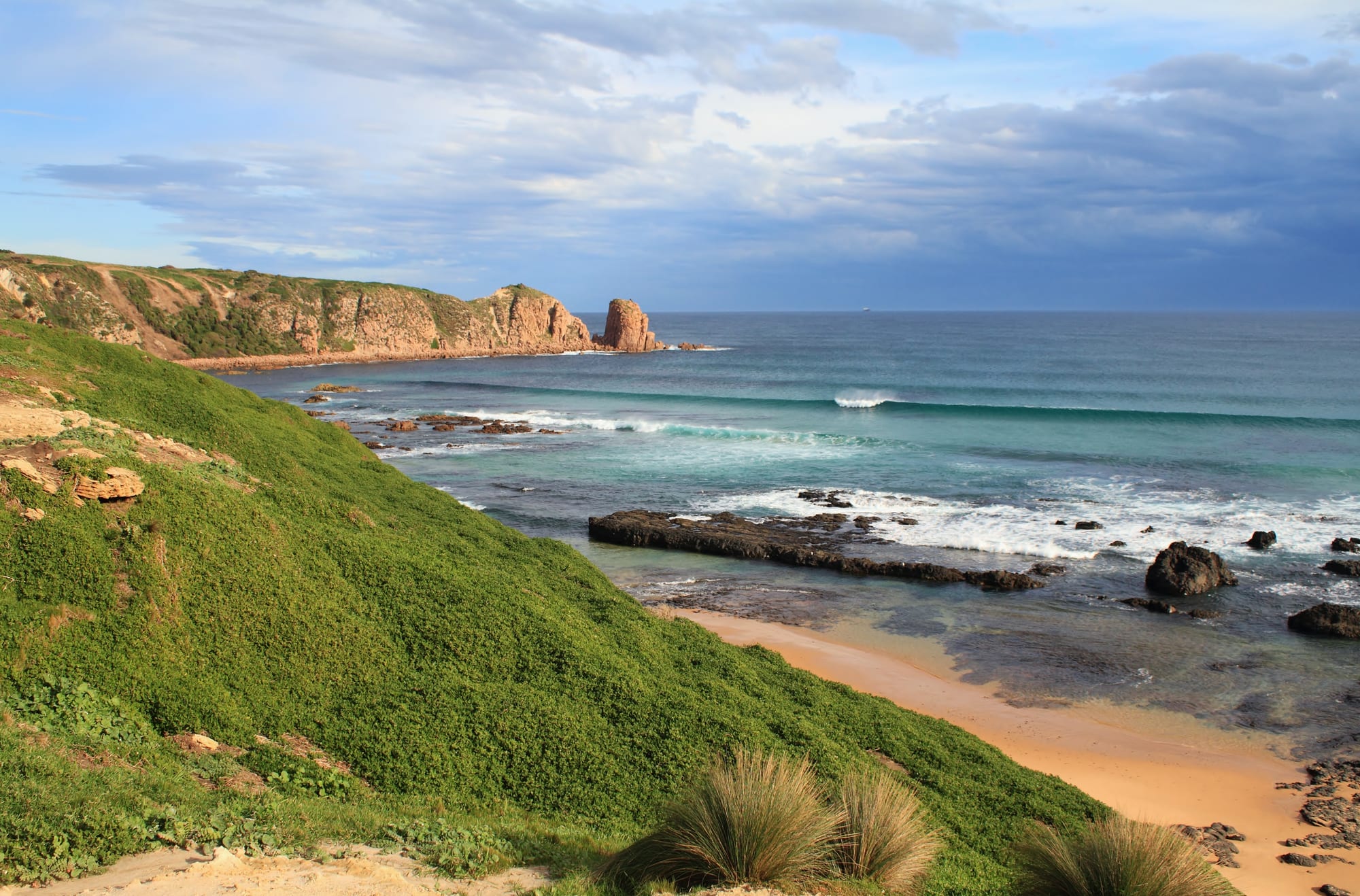
Green headland above a sandy beach and breaking surf, with the granite point of Cape Woolamai beyond

Melbourne & Victoria, Australia

Phillip Island

The coast at Cape Woolamai, on the south-eastern corner of Phillip Island. (Wampy1 / Wikimedia Commons · CC BY-SA 4.0)

An island at the mouth of Western Port, about two hours south-east of Melbourne and joined to the mainland by a single bridge. Farmland and holiday towns fill the middle, surf beaches and granite headlands the south coast, and wildlife reserves the western tip, where little penguins cross the sand at dusk.

Neighbourhoods

  • Cowes
    • First-time visitors
    • Best for food
    • Close to public transport

    The island's main town, on the sheltered northern shore facing Melbourne across the water. Thompson Avenue holds the shops, cafés and pubs, the long jetty and a calm swimming beach are at the bottom of it, and most of the island's hotels and holiday flats are within walking distance.

    Open in Maps
  • Newhaven
    • First-time visitors
    • Families

    The settlement at the island end of the bridge, the first place reached by road and the natural base for anyone arriving late. It has the island's visitor centre, a boat ramp and views back across the channel to San Remo.

    Open in Maps
  • Rhyll
    • Quiet and residential
    • Birdwatching

    A small fishing settlement on the north-east coast beside Rhyll Inlet, where mangroves and mudflats draw migratory wading birds. A boardwalk crosses the wetland, and the pace is much slower than Cowes.

    Open in Maps
  • Smiths Beach and the south coast
    • Beaches
    • Surfing

    A string of surf beaches along the exposed southern shore — Smiths Beach, Sunderland Bay and Berrys Beach among them — backed by low dunes and holiday houses. The swell is bigger here and the water colder than on the bay side.

    Open in Maps
  • Ventnor and the west end
    • Quiet and residential
    • Sunsets

    Farmland and scattered houses over the western half of the island, running out to the Summerland Peninsula and the wildlife reserves at the tip. Roads are quiet, paddocks come down to the cliffs, and it is the part of the island where the sun sets over the water.

    Open in Maps
  • San Remo
    • Best for food
    • Fishing

    On the mainland side of the bridge, a working fishing town with a co-operative that sells the day's catch, a jetty where pelicans gather, and cheaper rooms than the island itself.

    Open in Maps

Things to do

Wildlife and lookouts

  • Penguin Paradeattraction

    At Summerland Beach on the western tip, little penguins come ashore after sunset and cross the sand to their burrows, watched from boardwalks and tiered stands.

    Open in Maps
  • The Nobbies and Seal Rocksviewpoint

    Boardwalks over a windswept headland of basalt stacks and blowholes at the island's western point, looking out to Seal Rocks, where about 20,000 Australian fur seals breed, the second largest colony of the species in the world.

    Open in Maps
  • Cape Woolamaitrail

    The headland at the island's south-eastern tip, a faunal reserve with walking tracks above a surf beach and an important breeding colony of short-tailed shearwaters.

    Open in Maps
  • Koala Conservation Centreattraction

    Treetop boardwalks through eucalypt bush in the middle of the island, built so that koalas can be seen at eye level.

    Open in Maps
  • Churchill Islandattraction

    A small island joined by a bridge near Newhaven, where Lieutenant James Grant planted the first European garden and wheat crop in what is now Victoria in 1801; it is now a working heritage farm with restored cottages from the 1860s and an 1872 homestead.

    Open in Maps

The bay and the circuit

  • Western Portattraction

    The shallow bay north of the island, a wetland of mangroves and mudflats listed under the Ramsar Convention, with French Island and its ferry across the water.

    Open in Maps
  • Phillip Island Grand Prix Circuitattraction

    A fast seaside racing circuit opened in 1952, on an island where road racing began in 1928; it holds the world superbike round each February and has hosted the Australian motorcycle Grand Prix until 2026.

    Open in Maps

Short trips from the island

  • Kilcundaneighborhood

    A clifftop hamlet on the coast west of San Remo, with a long surf beach, the Bourne Creek railway trestle bridge and a stretch of the Bass Coast Rail Trail.

    Open in Maps
  • Inverlochneighborhood

    A holiday town east along the Bass Coast with a sheltered inlet beach, surf at the ocean end, and cliffs nearby where dinosaur fossils have been found.

    Open in Maps
  • Bunurong Marine National Parkpark

    Rock pools, reefs and small bays along the coast between Inverloch and Cape Paterson, good for snorkelling in calm weather.

    Open in Maps
  • Wilsons Promontory National Parkpark

    The southernmost point of mainland Australia, with granite peaks, white beaches and bush walks, a long drive east through Gippsland.

    Open in Maps

Seasonal events

  • Australian Motorcycle Grand PrixOctober

    A round of the MotoGP world championship at the island circuit and the island's busiest weekend of the year, when accommodation fills for miles around; the October 2026 race is the last before the event moves to Adelaide in 2027.

  • World Superbike roundFebruary

    The superbike world championship has held its Australian round at the circuit each February since 1990, often the opening round of the season and a cheaper, less crowded weekend than the Grand Prix.

Eat and drink

Long-standing places and food districts in Phillip Island. Hours, ratings and directions come from your maps app, always current.

Cowes and the north coast

  • Thompson Avenue, Cowesneighborhood

    The island's main street, running down to the pier, with bakeries, cafés, pizza and fish-and-chip shops, a couple of pubs and the island's widest choice of restaurants in a few blocks.

    Open in Maps
  • The Esplanade waterfrontneighborhood

    Cafés and restaurants along the foreshore at Cowes look north over Western Port, and the lawns and barbecues beside the jetty are where takeaway food is usually eaten.

    Open in Maps
  • Rhyllneighborhood

    A handful of places in the old fishing village serve seafood looking over the inlet, quieter than Cowes and popular on a still evening.

    Open in Maps

Across the bridge

  • San Remo fishermen's co-operativemarket

    A working co-op beside the jetty selling fish landed by the local fleet, along with fried fish to take away; pelicans gather on the ramp alongside.

    Open in Maps

Experience Phillip Island

History

The island is Millowl to the Bunurong, one of the peoples of the Kulin nations, whose country takes in Western Port and the coast on both sides of it. Middens and other sites record long use of the shellfish beds and the shearwater colonies. George Bass reached Western Port in 1798, and the island was named after Arthur Phillip, the first governor of New South Wales. In 1801 an expedition planted wheat and other crops on the small island in the bay that became Churchill Island, among the first European crops grown in what is now Victoria. Sealers worked the coast in the same period.

Farming followed from the 1840s, with sheep and cattle on the cleared grassland. The main township was surveyed in 1865 and named Cowes after the seaport on the Isle of Wight, and a ferry from Stony Point reached its new jetty from 1870. Visitors came by steamer to guesthouses at Cowes from the late 19th century, and the first bridge from San Remo opened in November 1940; the present concrete bridge replaced it at the start of the 1970s.

Motor racing and penguins built the modern economy. Road races were held on island roads from 1928, a purpose-built circuit opened in 1952, and the Australian motorcycle Grand Prix has been run at the circuit since 1997, moving to Adelaide from 2027. People had watched penguins at Summerland since the 1920s; from 1985 the state bought back and removed the housing estate built across the colony, and in the 1990s the reserves were brought under a single not-for-profit manager.

Culture & Customs

Phillip Island has two populations and two moods: a settled year-round community of about fourteen thousand, and the holiday crowd that arrives each summer and on long weekends. Much of local life is organised around that cycle — businesses that make their year in ten weeks, football and netball clubs that play through the quiet winter, surf life saving clubs that patrol from spring to autumn, and volunteer brigades and wildlife rescue groups staffed by residents.

Wildlife protection is close to a civic religion here, and the etiquette is unusually strict for an Australian holiday town: photography restrictions at the Penguin Parade, no feeding, dogs banned from many beaches and reserves, and reduced speed limits at the western end. Visitors who break the rules are corrected readily. The Bunurong connection to Millowl is acknowledged at the reserves, and traditional owners are involved in land management.

Surfing is the other strong thread, with a board-riding culture on the southern beaches going back decades and contests through the warmer months. Motorcycle racing has brought tens of thousands of fans each October, and a large crowd of riders to the roads, though the Grand Prix moves to Adelaide from 2027. English names — Cowes was named after the seaport on the Isle of Wight — sit alongside Aboriginal and pastoral ones, and whale watching from the Nobbies fills part of the winter, when humpback and southern right whales pass along the coast.

Daily Life

About fourteen thousand people live on the island all year, and the summer population rises to around forty thousand. Cowes is the service centre, with the supermarkets, medical clinics, secondary school and council offices; Newhaven, Rhyll, Ventnor and the beach settlements are largely residential. San Remo, across the bridge, functions as part of the same community.

Tourism is the largest employer, in accommodation, cafés, tours and the nature parks, and much of that work is seasonal and part-time. Farming continues on the island's interior — beef, sheep and some grapes — and San Remo keeps a working fishing fleet. Many residents commute to Wonthaggi or further up the highway for work, and a growing number of people who have moved from Melbourne work remotely.

Growth is the recurring local argument. Retirees and remote workers have pushed house prices up, short-stay letting has taken houses out of the long-term rental market, and the staff who run the tourist economy struggle to find somewhere to live. Traffic across the single bridge, the capacity of water and sewerage services, coastal erosion and the pressure of visitor numbers on penguin and shearwater colonies all feature in council debates. Wildlife killed on the roads is a constant concern, and residents are used to seeing carers carrying injured animals away.

Food

Seafood is the island's strength. The co-operative beside the jetty at San Remo sells what the local boats land — flathead, whiting, gummy shark sold as flake, calamari and, in season, southern rock lobster — and fried fish eaten on the foreshore with the pelicans watching is close to a local ritual. Restaurants in Cowes and Rhyll lean the same way, with oysters and mussels from Victorian waters and simply grilled fish.

The land food comes from the Bass Coast and Gippsland behind it: beef and lamb from the island's own paddocks, dairy from the green country inland, berries and vegetables from market gardens, and farmers' markets in the district selling cheese, bread and preserves. Small vineyards on the island make cool-climate wine in tiny quantities, and craft brewers have opened along the coast.

Holiday food is much as it is anywhere on the Victorian coast: bakery pies and sausage rolls, fish and chips in paper, ice creams on the main street, coffee taken seriously even in a small town, and a pub meal of parma or steak. The pelican feeding at the San Remo jetty each midday is a fixture of its own, and barbecue plates in the foreshore reserves get constant use on summer evenings.

Planning tools

Budget

Accommodation drives the cost. Motels, holiday flats and caravan parks are reasonable outside the peak, then jump in the December and January school holidays, at Easter and above all on the October Grand Prix weekend, when rooms are taken months ahead. The island's wildlife attractions are run by one not-for-profit organisation and charge entry, which is the other main item; beaches, walks and lookouts are free.

Daily Budget Midrange
USD 170–300 (motel or holiday flat, restaurant meals, entry to two or three wildlife attractions, a hire car)
Daily Budget Shoestring
USD 80–130 (caravan park cabin or hostel bed, self-catering, sharing the cost of a car)

The wildlife attractions are sold as combined tickets as well as singly, which is cheaper for anyone visiting more than one; self-catering saves a great deal in a town where most holiday flats have a kitchen.

Best Time to Visit

December to March is warmest and busiest, with long evenings and the shearwaters ashore. Penguins come in every night of the year, later in the evening in summer and in daylight-saving dusk. Autumn and spring are mild and much quieter, whales pass the coast between about May and September, and winter is windy and wet but good for empty beaches and wildlife.

Suggested Number of Days

Two days suits the island, since the wildlife viewing happens after sunset and makes a day trip from Melbourne a long one. Three or four days allow the surf beaches, the walking tracks and the Gippsland coast beyond the bridge. Bad weather is the main reason to allow more.

First Visit
2 days
With Surroundings
3–4 days

Transportation

The island is about 26 kilometres long, and a car is the practical way to cross it: the beaches, the circuit and the reserves at the western tip are 10 to 20 kilometres apart. A coach service runs between Melbourne and Cowes, an infrequent local bus links Cowes, Newhaven and San Remo, and day tours from the city cover the main attractions. Cycling is pleasant on the quieter back roads but the main roads carry fast traffic.

Drive slowly after dark and at dawn: wallabies, wombats and penguins cross island roads, and the western roads have reduced speed limits for that reason.

Airport & Station Connections

Most visitors drive from Melbourne — about 140 kilometres by the Monash Freeway and the Bass Highway, roughly two hours without stops — and cross the bridge from San Remo to Newhaven, the only road onto the island. A passenger ferry crosses Western Port from Stony Point on the Mornington Peninsula to Cowes by way of French Island, useful for anyone linking the two peninsulas. Melbourne Airport is about two and a half hours away.

Walkability

Cowes is easy on foot: the shops, the beach and the pier are all on one street. Newhaven, Rhyll and San Remo are small enough to walk in minutes. Between the towns there are few footpaths and long distances, so walking is for the coastal tracks and boardwalks rather than for getting about. Paths at the main reserves are level and mostly boarded.

Safety

The island is safe, with natural hazards the main concern. Surf beaches on the south coast have strong rips and cold water, and only some are patrolled in summer; the bay beaches at Cowes and Rhyll are calmer. Cliff edges at the western headlands are unfenced in places and the rock is crumbly. Wind and sun are stronger than they feel, and traffic on the bridge and the Bass Highway is heavy on holiday weekends.

Swim between the flags at patrolled beaches and not at all on unpatrolled surf beaches, keep to boardwalks at the headlands, drive slowly at night for wildlife, and check fire danger ratings in summer. Check current official travel advice before travelling.

Climate

Temperate maritime and windy, with weather that changes through the day. The island is cooler than Melbourne in summer and a little milder in winter, and rain falls in every month, most of it between May and September. The sea stays cold all year.

Summer
mild and breezy — December to February, the southern summer, is typically 13–24°C, with occasional hot northerly days above 30°C before a cool change
Winter
cool, wet and windy — June to August days reach about 13–14°C with nights near 7°C, and southerly gales blow through

Local Customs

This is a relaxed holiday island: dress is casual, bare feet and wetsuits are normal near the beach, and people are greeted by first name. The island is Millowl in the language of the Bunurong, its traditional owners, and their connection to it is acknowledged at the reserves. Wildlife rules are taken seriously by residents, from feeding bans to keeping dogs off penguin beaches.

Follow the photography restrictions at the Penguin Parade, where flashes and screens disturb the birds; do not feed wild animals, take rubbish away from beaches, and note that the legal drinking age is 18. Tipping is not expected.

Common Payment Methods

The currency is the Australian dollar. Cards and contactless payment are taken almost everywhere, including small cafés and the fish co-op, and card surcharges are common and must be displayed. Cash machines are in Cowes, Newhaven and San Remo; a little cash is handy for markets, honesty boxes at farm gates and community stalls.