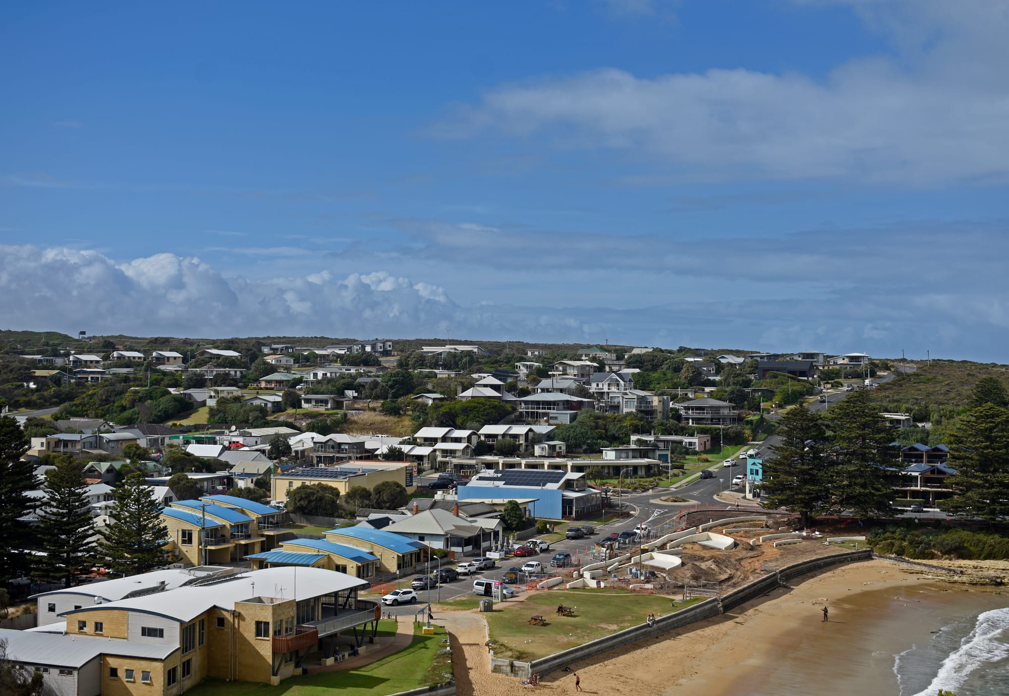
Low houses and a main street above Port Campbell's sandy beach and bay under a bright sky

Melbourne & Victoria, Australia

Port Campbell

Port Campbell and its beach, seen from the walking track on the headland above the bay. (Ymblanter / Wikimedia Commons · CC BY-SA 4.0)

A small town on Victoria's south-west coast, built around the one sheltered bay in a long line of limestone cliffs. Traders and fishermen used the inlet before the Great Ocean Road brought visitors to the Twelve Apostles and Loch Ard Gorge nearby. Today a few streets of houses, cafés and caravan parks serve the Shipwreck Coast.

Neighbourhoods

  • Lord Street and the town centre
    • First-time visitors
    • Best for food

    The main street runs down the hill to the bay and holds almost everything the town has — cafés, a bakery, a pub, a general store, the visitor centre and several motels and guesthouses. Nothing in it is more than a few minutes from the sand.

    Open in Maps
  • The bay and the beach
    • Beaches
    • Families

    A short crescent of sand at the mouth of the creek, closed in by cliffs on both sides and calm enough to swim when the surf outside is heavy. A jetty, a boat ramp and the surf life saving club sit at the eastern end, and grassy foreshore reserves back the beach.

    Open in Maps
  • The headlands above the town
    • Quiet and residential
    • Walks and viewpoints

    Holiday houses and cabins spread over the clifftops on either side of the bay, where cliff-top tracks give the long view back over the roofs to the Southern Ocean. It is a steep walk up from the beach and noticeably windier at the top.

    Open in Maps
  • Princetown
    • Quiet and residential
    • Close to the cliffs

    A hamlet of a few dozen houses on the Gellibrand River east of Port Campbell, at the edge of the wetlands near the end of the Great Ocean Walk. It is the closest settlement to the Twelve Apostles, about six kilometres away, with a pub that doubles as a general store, a post office and very little else.

    Open in Maps
  • Peterborough
    • Beaches
    • Golf and fishing

    A quieter holiday village west of Port Campbell at the mouth of the Curdies River, with a river beach, a nine-hole golf course and the arches and rock stacks of the coast on its doorstep.

    Open in Maps

Things to do

Cliffs, stacks and gorges

  • The Twelve Apostleslandmark

    The best-known group of limestone stacks on the coast, standing offshore below the cliffs east of the town; seven of the original nine remain, after collapses in 2005 and 2009.

    Open in Maps
  • Loch Ard Gorgeattraction

    A narrow inlet with a sheltered beach between sheer walls, named after the clipper wrecked offshore in 1878, with short walks to the cemetery and to the beach where the two survivors came ashore.

    Open in Maps
  • Gibson Stepsattraction

    A stairway cut and built into the cliff face that leads down to a long beach at the foot of the Apostles, closed when the sea runs high.

    Open in Maps
  • London Archlandmark

    An offshore arch near Peterborough, known as London Bridge until the span joining it to the mainland collapsed in 1990.

    Open in Maps
  • Bay of Islands Coastal Parkpark

    A quieter stretch of stacks, bays and heathland west of Peterborough, with lookouts that are often almost empty.

    Open in Maps

Parks and walks

  • Port Campbell National Parkpark

    The 1,750-hectare strip of park that protects the limestone coast either side of the town, from Peterborough east to Princetown, along with its heathland, seabird colonies and lookout tracks.

    Open in Maps
  • Great Ocean Walktrail

    A long-distance coastal walking track from Apollo Bay that finishes at the Twelve Apostles, walked in full over several days or in short sections from road access points.

    Open in Maps
  • Great Ocean Roadattraction

    The coast road built largely by returned First World War soldiers as a memorial, which passes through the town and links it to the surf coast and the Otway forests.

    Open in Maps

Short trips along the Shipwreck Coast

  • Flagstaff Hill Maritime Villagemuseum

    In Warrnambool, an open-air museum of the shipwreck coast laid out as an 1870s village around the port's original lighthouses, holding the Loch Ard peacock, a Minton porcelain figure recovered intact from the 1878 wreck.

    Open in Maps
  • Great Otway National Parkpark

    Tall wet forest, tree ferns and waterfalls inland and east of the cliffs, with a rainforest walk at Melba Gully and glow-worms after dark.

    Open in Maps
  • Cape Otway Lightstationlandmark

    The oldest surviving lighthouse on mainland Australia, first lit in 1848 and in service until 1994, on the cape marking the western entrance to Bass Strait.

    Open in Maps
  • Port Fairyneighborhood

    A former whaling and sealing port further west, with bluestone and timber cottages, a working fishing fleet and a short-tailed shearwater colony on Griffiths Island.

    Open in Maps

Eat and drink

Long-standing places and food districts in Port Campbell. Hours, ratings and directions come from your maps app, always current.

Eating in the town

  • Lord Street cafés, bakery and pubneighborhood

    The town's handful of eating places stand within a block or two of each other on the main street — coffee and breakfast, a bakery, fish and chips to take to the foreshore, and a pub dining room where fish of the day and a chicken parma are the staples.

    Open in Maps
  • The foreshore and the beach kiosksneighborhood

    Grass, picnic tables and shelters run along the back of the beach, and takeaway food from the street is usually eaten here rather than indoors; gulls are persistent.

    Open in Maps

Food country nearby

  • Timboonneighborhood

    A dairy town about 20 kilometres inland whose small producers make cheese, dairy goods and whisky, the distillery in the former railway goods shed on the old line, and whose rail trail is walked and cycled from the town centre.

    Open in Maps
  • Port Fairy and Warrnambool seafoodneighborhood

    The nearest towns with a real choice of restaurants, both landing southern rock lobster and fish from the same waters; the catch is sold from co-ops and cooked simply.

    Open in Maps

Experience Port Campbell

History

This coast is the traditional country of Aboriginal peoples of Victoria's Western District, who lived along the limestone cliffs and the creek mouths long before Europeans arrived, and middens and other sites survive in the heathland above the sea. Sealers and whalers worked the shore from the 1830s, and the bay — the only sheltered landing for many kilometres — took the name of Captain Alexander Campbell, a whaler based at Port Fairy. A fishing and farming settlement grew around the inlet in the second half of the 19th century, with a jetty for shipping produce out when the roads inland were little more than tracks.

The cliffs gave the coast its other name. Ships bound for Melbourne from Britain had to find the narrow entrance to Bass Strait, and dozens came to grief between Cape Otway and Port Fairy on what became known as the Shipwreck Coast. The most remembered is the Loch Ard, a clipper carrying immigrants from England that ran aground on a reef in the dark on 1 June 1878; only two of those aboard survived, and the gorge where they came ashore still carries the ship's name. The Falls of Halladale ran aground near Peterborough in 1908.

Tourism arrived with the Great Ocean Road, built between 1919 and 1932 largely by returned First World War soldiers as a memorial to the dead. The cliffs were protected as Port Campbell National Park in the 1960s, and as coach tours and then hire cars multiplied, the lookouts east of the town became among the most visited places in Victoria. The town has stayed small while the traffic past it has grown enormously.

Culture & Customs

Port Campbell lives with a scale of visitor numbers far beyond its size, and local culture is shaped by that contrast. Residents talk about the coast in terms of weather and swell rather than sights, and the rhythm of the year is a crowded summer followed by a long, windy off-season when the town belongs to itself again. Helicopters working the Apostles and tour coaches on the highway are part of the background.

Volunteer institutions hold the place together. The surf life saving club patrols the bay beach, the Country Fire Authority brigade and the State Emergency Service turn out to fires, storms and road crashes, and the marine rescue crew launches into a coast with no other harbour. Their sausage sizzles, raffles and dinners are the main social events, along with the Anzac Day dawn service and the local football and netball clubs, which draw players from the farms inland.

The shipwrecks are the town's shared story, retold in the cemeteries and memorials along the cliffs and at the maritime museum in Warrnambool. In recent decades Aboriginal heritage has become more visible in interpretation along the coast, with traditional owners involved in managing the national park. Manners are informal — first names, casual clothes, a nod or a raised finger from a car — and questions about the best lookout are answered readily, usually with the advice to go early or late.

Daily Life

Fewer than a thousand people live in Port Campbell year-round, and the number in the town can multiply many times over on a January weekend. Tourism is the main employer: motels, caravan parks, cafés, the general store, tour operators and the national park. Inland, the country is dairy, beef and potatoes, and some households combine farm work with a job in town. A number of residents commute to Timboon, Cobden or Warrnambool for work or school.

The practical side of a small coastal town shapes the day. There is a school, a few shops, a medical service and a community centre; anything more — a supermarket shop, a hospital, a hardware store — means a drive of half an hour or more. Mobile coverage and internet speeds vary along the cliffs, water supply matters in dry summers, and tradespeople are booked well ahead.

Housing is the pressing issue, as it is in holiday towns along the whole coast. Many houses stand empty for much of the year or are let to visitors, which leaves little for the people who staff the cafés and cabins, and workers are sometimes housed well inland. Coastal erosion is the other constant subject: the cliffs and stacks that bring the visitors are wearing back, and tracks, stairs and lookouts are rebuilt or moved as the sea takes the rock.

Food

Seafood and dairy define the table here. Boats from the small ports along this coast land southern rock lobster — known locally as crayfish — along with flathead, whiting and snapper, and abalone divers work the reefs offshore. Fish and chips eaten on the foreshore is the town's standard meal, and the pub kitchen turns out a chicken parma, steak and the catch of the day.

Inland the country is some of the best dairy land in Australia, and the produce of the Western District is easy to find: milk and cream, cheddar and washed-rind cheeses, butter and thick ice cream made close to where the cows graze. Timboon, about 20 kilometres north, has built a small food reputation on cheese, dairy produce and a whisky distillery in the old railway goods shed, and the district's beef and lamb appear on menus along the coast. Roadside stalls and honesty boxes sell potatoes, apples and eggs in season.

Otherwise the food is straightforward Australian country cooking. Bakeries sell meat pies, sausage rolls, lamington slices and vanilla slices; morning coffee is taken seriously even in a town this size, a Victorian habit that reaches well beyond Melbourne; and the barbecue plates on the foreshore reserves get heavy use on summer evenings. Beer and cool-climate wines from further along the coast and from the ranges inland fill out the drinks list.

Planning tools

Budget

Beds are the main cost. Port Campbell has only a few dozen rooms between its motels, guesthouses and caravan parks, so prices climb steeply in the December and January school holidays, at Easter and on long weekends, and rooms sell out months ahead. Almost everything else is cheap or free: the lookouts, beaches and walking tracks charge nothing and their car parks are free. Most visitors are paying for a hire car as well.

Daily Budget Midrange
USD 180–300 (motel or guesthouse room, meals in the town, a hire car for the coast)
Daily Budget Shoestring
USD 80–130 (caravan park cabin or hostel bed, self-catering from the general store, sharing the cost of a car)

Book accommodation well ahead for summer and Easter, and expect to pay more for a coastal view than for the same room a few streets back.

Best Time to Visit

November to April has the warmest, longest days, with January and the weeks around Easter by far the busiest. March to May is the most settled time: mild, clearer and much quieter. Winter brings rain, wind and big swells against the cliffs, which is dramatic rather than pleasant, and southern right whales calve along this coast in winter, with cows and calves seen off Warrnambool from about late May to August.

Suggested Number of Days

A night or two is enough for the town and the cliffs on either side of it. Three or four days suits anyone continuing along the coast road or walking sections of the coastal track. Weather decides a great deal here, so a spare day is worth having.

First Visit
1–2 days
With Surroundings
3–4 days

Transportation

A car is close to essential. The town itself is small enough to cross on foot, but the lookouts are spread over 30 kilometres of coast with no local bus, and the nearest large towns are an hour or more away. A limited regional coach service runs along the coast and connects with trains at Warrnambool and Geelong, and day tours from Melbourne stop here. Petrol stations are few and far between along this coast.

Roads are narrow, winding and busy with tour coaches; kangaroos and wallabies come out at dusk, when many collisions happen.

Airport & Station Connections

Most people drive from Melbourne. The quick inland route by the Princes Highway through Colac is about 230 kilometres and takes roughly three hours; the coastal route along the Great Ocean Road through Lorne and Apollo Bay is longer and takes most of a day with stops. Warrnambool, about 65 kilometres west, is the end of the train line from Melbourne and the usual arrival point for those without a car.

Walkability

The town is entirely walkable — a single main street, the beach at the bottom of it and cliff tracks starting from both ends of the bay. The climb up to the clifftop houses is steep and exposed. Beyond the town there are no footpaths along the highway, so reaching the stacks and gorges means driving or joining a tour.

Safety

The dangers here are natural rather than criminal. The cliffs are soft limestone that collapses without warning, and people have been killed ignoring fences and warning signs at the edge and on beaches below. The Southern Ocean is cold all year, with strong rips, and only the bay beach in the town is patrolled, in summer. Bushfire is a risk in the heathland during hot, windy weather.

Stay behind the barriers and on the boardwalks at every lookout, swim between the flags at the town beach, keep off beaches at the base of cliffs when the sea is up, and check fire danger ratings in summer. Check current official travel advice before travelling.

Climate

Cool temperate and fully exposed to the Southern Ocean, so wind is the constant. Weather changes quickly, rain comes in short bursts at any time of year, and it is usually several degrees cooler and windier on the clifftops than a short way inland.

Summer
mild rather than hot — December to February, the southern summer, is typically 13–23°C, though hot northerly winds can push the temperature well above 30°C for a day before a cool change arrives
Winter
cool, wet and windy — June to August days reach about 13–14°C with nights near 7°C, and storms drive heavy swells onto the cliffs

Local Customs

This is small-town coastal Victoria: dress is casual, people are greeted by first name, and drivers on back roads often lift a finger from the wheel in greeting. The volunteer fire brigade, surf life saving club and sea rescue unit are run by residents, and their fundraisers are the town's social calendar. Anzac Day on 25 April is marked with a dawn service. The shipwreck cemeteries along the coast are burial grounds and are treated quietly.

Tipping is not expected, though change is often left in a jar; the legal drinking age is 18 and alcohol is sold in licensed shops and the pub; take farm gates as found, and follow the signs at Aboriginal heritage sites along the coast.

Common Payment Methods

The currency is the Australian dollar. Cards and contactless payment work almost everywhere, including small cafés, and some places no longer accept cash; a surcharge on card payments is common and must be displayed. Cash machines are few in villages along the coast, so a small amount of cash is worth carrying for markets, honesty boxes and community fundraisers.