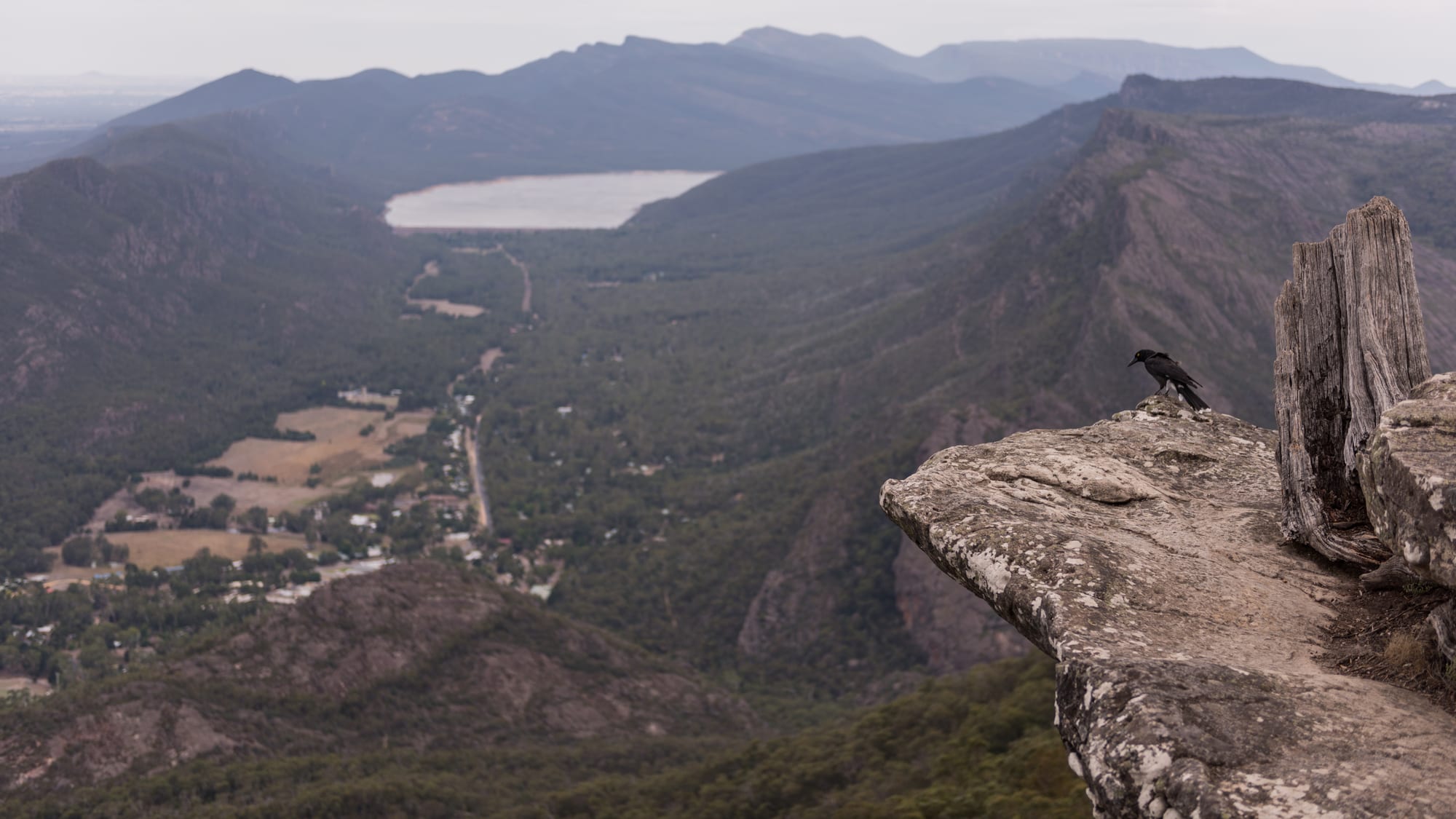
Rocky lookout above a wooded valley holding the small town of Halls Gap, with a reservoir and ranges beyond

Melbourne & Victoria, Australia

Halls Gap

Halls Gap and the Fyans Valley seen from Boroka Lookout in the Grampians. (Peter Trenchard / Wikimedia Commons · CC BY-SA 4.0)

A village of a few hundred people in the Fyans Valley, wedged between sandstone ranges in the Grampians of western Victoria. It exists almost entirely to serve the national park around it, which holds waterfalls, cliff-top lookouts, long walking trails and about 90 per cent of Victoria's Aboriginal rock art.

Neighbourhoods

  • The village centre
    • First-time visitors
    • Best for food
    • Close to the trailheads

    A single strip of shops, cafés and a small supermarket beside Stony Creek, with the park visitor information and the cultural centre a short way south. Almost every bed in the village is within ten minutes' walk, and walking tracks start from the edge of the car parks.

    Open in Maps
  • Stony Creek and the caravan parks
    • Families
    • Camping and cabins

    Holiday parks, cabins and the recreation reserve spread along the flat ground beside the creek north of the shops. Kangaroos graze the ovals and lawns at dusk, and it is the cheapest part of the village to stay in.

    Open in Maps
  • The Lake Bellfield end
    • Quiet and residential
    • Views

    South of the village, Grampians Road climbs past motels and guest houses towards the reservoir wall, with the Mount William Range rising on one side. Quieter than the centre and a few minutes' drive from the southern lookouts.

    Open in Maps
  • Pomonal
    • Quiet and residential
    • Gardens and nurseries

    A scattered settlement on the eastern side of the ranges, about 10 kilometres from Halls Gap, known for its nurseries and native gardens and used as a quieter base with farm-stay accommodation.

    Open in Maps
  • Wartook Valley
    • Quiet and residential
    • Farm stays

    Farmland and bush on the north-western side of the ranges, reached by a long drive around the mountains. Cottages, farm stays and a reservoir sit below the escarpment, well away from the village crowds.

    Open in Maps

Things to do

Walks, peaks and waterfalls

  • Grampians National Parkpark

    The park that surrounds the village, covering sandstone ranges that rise abruptly from the Wimmera plains, with lookouts, waterfalls, spring wildflowers and rock-art shelters.

    Open in Maps
  • Mackenzie Fallsattraction

    The park's best-known waterfall, dropping into a gorge on the Mackenzie River about 20 kilometres from the village, reached by a steep stepped path or viewed from a lookout above.

    Open in Maps
  • Mount Williamviewpoint

    The highest point of the Grampians, about 22 kilometres' drive south of the village, with a sealed road to a car park part of the way up and a walk of 1.8 kilometres to the summit view over the plains.

    Open in Maps
  • Grampians Peaks Trailtrail

    A long-distance walking trail of about 160 kilometres running the length of the ranges, completed in 2021, walked in full over about two weeks or in day sections from Halls Gap.

    Open in Maps
  • Lake Bellfieldattraction

    The reservoir immediately south of the village, which flooded the site of the original settlement, with a wall walk and views across the water to the ranges.

    Open in Maps

Culture and wildlife

  • Brambuk cultural centremuseum

    Australia's longest-running Aboriginal cultural centre, at the southern edge of the village, owned and managed by Jardwadjali and Djab Wurrung people from five communities with links to Gariwerd.

    Open in Maps
  • Bunjil's Shelterlandmark

    A shelter at the base of a large granite boulder in the Black Range Scenic Reserve, the only known rock-art site to show Bunjil, a creator figure, with two dingoes; it is screened and reached by a short walk.

    Open in Maps
  • Halls Gap Zooattraction

    Victoria's largest regional zoo, about 7 kilometres from the village, holding more than 120 native and exotic species.

    Open in Maps

Short trips from the village

  • Stawellneighborhood

    The nearest town of any size, a former gold-mining centre with supermarkets, a hospital and a grass running track used for a professional footrace at Easter.

    Open in Maps
  • Great Westernneighborhood

    A village at the heart of the Grampians wine region, known for sparkling wine matured in tunnels dug by gold miners in the 19th century.

    Open in Maps
  • Dunkeldneighborhood

    A small town at the southern end of the ranges below Mount Sturgeon and Mount Abrupt, a quieter way into the park from the south.

    Open in Maps
  • Mount Arapileslandmark

    An isolated sandstone outcrop on the plains to the north-west, one of the best-known rock-climbing areas in Australia, where Parks Victoria has closed some climbing, with walks to the summit for non-climbers.

    Open in Maps

Seasonal events

  • Grampians Grape EscapeMay

    One of Australia's longest-running food and wine festivals, launched in 1992 and held at Halls Gap on the first weekend of May, with more than 100 local producers, music and family events.

  • Stawell GiftEaster

    Australia's oldest and richest short-distance footrace, run on grass over 120 metres at Stawell on the Easter weekend since 1878 and followed closely across the district.

  • Wildflower seasonSeptember to November

    Spring brings the Grampians' best-known natural display: the ranges hold 975 native plant species, among them more than 75 orchids, and a third of Victoria's flora.

Eat and drink

Long-standing places and food districts in Halls Gap. Hours, ratings and directions come from your maps app, always current.

Eating in the village

  • The Stony Creek shopsneighborhood

    The village's cafés, bakery, takeaway shops, hotel dining room and a small supermarket stand together in one short strip, and most of them serve breakfast early for walkers.

    Open in Maps
  • Halls Gap picnic groundsneighborhood

    Free electric barbecues, tables and shelters in the reserves beside the creek, where much of the village's eating actually happens on a summer evening.

    Open in Maps

Wine and produce nearby

  • Great Western wineriesneighborhood

    Cellar doors east of the ranges pour the sparkling wine and shiraz the district is known for, some of it stored in underground tunnels cut by gold miners.

    Open in Maps
  • Royal Mail Hotel, Dunkeldrestaurant

    A country hotel at the southern end of the ranges with a long-established dining room, a large kitchen garden and a reputation that reaches well beyond western Victoria.

    Open in Maps

Experience Halls Gap

History

The ranges are Gariwerd, the country of the Jardwadjali and Djab Wurrung peoples, who have lived among them for tens of thousands of years. Their shelters hold one of the richest bodies of rock art in south-eastern Australia — hand stencils and figures painted in ochre — and about 90 per cent of the rock art recorded in Victoria is in these ranges. Seasonal camps, stone-tool quarries and fish and eel traps in the surrounding wetlands recorded a settled way of life across the district.

Major Thomas Mitchell reached the ranges in 1836, climbed the highest peak and named the whole group after the Grampian Mountains of Scotland. Squatters and their sheep followed within a few years; in 1841 the stockman Charles Browning Hall came through the gap in the ranges that took his name, and the settlement in the valley below became Halls Gap. Sawmilling, grazing and a little gold followed, along with water: reservoirs in the ranges carry Grampians water out to the dry Wimmera, and Lake Bellfield flooded the original village site south of the present one.

Tourism arrived early. Coach parties came from the railway at Stawell in the 19th century for the Wonderland walks and waterfalls, and guesthouses opened in the village. The Grampians became a national park in 1984, Brambuk — Australia's longest-running Aboriginal cultural centre, run by traditional owner communities — stands in the village, and the Grampians Peaks Trail was completed in 2021. A lightning fire burned almost half the park in January 2006, and the 2024–25 bushfires burned about 136,000 hectares of the park and nearby farmland.

Culture & Customs

Halls Gap is a walkers' village, and its culture follows the tracks: early breakfasts, boots outside cabin doors, talk of which lookouts have reopened after rain or fire, and a rhythm set by the seasons rather than the week. Spring, when the wildflowers are out, and Easter are the high points of the year; midwinter belongs to the locals.

Aboriginal culture is unusually visible for a small Victorian town. The Grampians hold the state's richest concentration of rock art, traditional owner groups are partners in managing the park, guided cultural walks operate from the village, and the dual name Gariwerd is in everyday use on signs and maps. The protocols around the shelters — looking without touching, keeping behind the screens — are taken seriously by residents and rangers.

Rock climbing and abseiling have long been part of the local identity, and the negotiation of access between climbers, park managers and traditional owners has been a live local issue. Wildlife is a shared civic subject too: kangaroos grazing on the recreation reserve, cockatoos on the power lines, deer damaging gardens. Fire shapes everything — every household knows its plan, the volunteer brigade is central to the community, and residents talk about past fire seasons the way coastal towns talk about storms.

Daily Life

Only a few hundred people live in Halls Gap permanently, while on a busy holiday weekend the number of people in the valley can be twenty or thirty times that. Tourism is the whole economy: caravan parks, motels, cafés, tour and shuttle operators, the zoo, the cultural centre and Parks Victoria. Much of the work is seasonal, and staff housing is scarce enough that some workers commute from Stawell and Ararat.

The village has a small school, a general store, a post office, a bakery and a community hall, but anything larger — a supermarket shop, a doctor, a hardware store, a secondary school — means a drive of half an hour or more to Stawell or Ararat, or an hour to Horsham. Mobile coverage is patchy once the road enters the ranges, and power failures in storms are routine.

The year turns on the fire season. From about November residents watch the forecasts, clear gutters and gardens, and the district practises its warnings; in a bad summer the village empties on official advice. Recovery after the fires of recent summers has been a long process for businesses that depend on the park being open. Water, kept in the reservoirs for Wimmera towns as well as for the valley, and the balance between visitor numbers and a fragile landscape are the other steady preoccupations.

Food

Eating in Halls Gap is straightforward: a bakery turning out pies, sausage rolls and vanilla slices, cafés doing big breakfasts and coffee for walkers, a takeaway or two, a hotel dining room with parma, steak and fish, and one small supermarket that everyone in the valley uses. Free barbecues in the reserves see constant use, and picnic food is bought in the village and carried into the park.

The surrounding district supplies rather more. The Grampians is a recognised wine region, with Great Western to the east known since the 19th century for sparkling wine kept in tunnels cut by gold miners, and for peppery shiraz; the Pyrenees ranges beyond it make reds as well. The Wimmera plains to the north grow wheat, canola, lentils and chickpeas — Australia's pulse country — while lamb, beef and wool come off the paddocks closer in. Olive groves, honey from box and ironbark blossom, and roadside stalls selling eggs, fruit and jam fill out the local list, and there are a few small breweries and distilleries in the district.

Aboriginal-run tourism and the cultural centre have brought native ingredients onto local menus — kangaroo, emu, wattleseed, bush tomato, lemon myrtle and the yam daisy, a staple food of the region before European settlement. South of the ranges, the hotel at Dunkeld has built a national reputation on its kitchen garden and on produce from the same country.

Planning tools

Budget

Halls Gap is cheap by Victorian standards outside the peaks. Campsites, caravan-park cabins, a hostel and motels make up most of the beds, and prices climb at Easter, in the school holidays, on long weekends and during the spring wildflower season, when the village books out. Entry to the national park and its lookouts costs nothing; a car is the unavoidable expense.

Daily Budget Midrange
USD 170–290 (motel room or cabin, meals in the village, a hire car for the park roads)
Daily Budget Shoestring
USD 70–120 (campsite or hostel bed, self-catering, sharing the cost of a car, free park walks)

Walks, lookouts and rock-art shelters are free; the village shop is small and dearer than a supermarket, so anyone self-catering does better to shop in Stawell or Ararat on the way in.

Best Time to Visit

September to November is the classic season, with wildflowers, full waterfalls and mild walking weather. March to May is settled, quiet and comfortable. Summer is hot and carries real bushfire risk, which can close park roads and tracks at short notice. Winter is cold, wet and often misty, but the waterfalls run hardest and the village is almost empty.

Suggested Number of Days

Two or three days is enough for the walks and lookouts within reach of the village. Four or five allow the northern and southern ends of the ranges, the rock-art shelters and the wine country. Walkers taking on the long-distance trail need up to a fortnight, and weather often changes plans.

First Visit
2–3 days
With Surroundings
4–5 days

Transportation

A car is effectively necessary. Trailheads and lookouts are spread over 20 to 60 kilometres of park roads, there is no local bus, and taxis are not based in the village. Main park roads are sealed, while some tracks to remoter shelters and campsites are gravel and a few need a high-clearance vehicle. Coaches connect with V/Line trains at Ararat and Stawell, and tour operators run day trips from Melbourne and Ballarat.

Kangaroos, emus and deer are on the roads at dawn and dusk, park roads are winding with blind bends, and fuel in the village is limited, so fill up in Stawell or Horsham.

Airport & Station Connections

Most visitors drive from Melbourne: about 260 kilometres on the Western Highway through Ballarat and Ararat, then into the ranges, which takes roughly three hours. Adelaide is about 600 kilometres west, a long day's drive. Without a car, V/Line runs trains from Melbourne towards Ararat with connecting coaches into the Grampians, and day tours come up from Melbourne and Ballarat.

Walkability

The village is a short walk end to end, and several tracks — along the creek, to the Botanic Gardens and up towards the escarpment — begin within it, which is unusual for an Australian park town. Everything further means driving: the park roads have no footpaths, verges are narrow and traffic is faster than it looks.

Safety

Bushfire is the serious hazard. Large fires burned through the ranges in January 2006, twice more in the years since, and again over the summer of 2024–25, and on high-danger days walks and roads are closed and visitors are asked to leave. Otherwise the risks are the ordinary ones of walking country: heat and dehydration, unfenced cliff edges at the lookouts, loose rock, sudden cold and mist on the tops, and snakes in warm weather.

Check fire danger ratings and the VicEmergency service daily in summer, carry far more water than seems necessary, tell someone the route before a long walk, stay behind barriers at lookouts and keep to marked tracks. Check current official travel advice before travelling.

Climate

Temperate, with hot dry summers and cool wet winters. The ranges make their own weather: they are several degrees cooler and considerably wetter than the surrounding plains, cloud sits on the peaks, and conditions on an exposed ridge differ sharply from the valley floor.

Summer
hot and dry — December to February, the southern summer, is typically 13–28°C in the valley, with heatwave days above 35°C and high fire danger
Winter
cold and wet — June to August days reach about 12–13°C with frosty nights near 3°C, mist on the ranges, and an occasional dusting of snow on the highest peaks

Local Customs

The ranges are Gariwerd in the languages of the Jardwadjali and Djab Wurrung peoples, the traditional owners, and that name is now used alongside Grampians for the park; rock-art shelters are protected places rather than sights, and the paintings must never be touched. Village life is informal and slow, shops keep country hours, and walkers greet each other on the tracks. Kangaroos on the ovals and verges are wild animals, not attractions to approach or feed.

Obey fire restrictions and total fire ban days, when no open flame is allowed anywhere outdoors; take all rubbish out of the park, keep dogs out of it altogether, and view rock art from behind the screens. Tipping is not expected, and the legal drinking age is 18.

Common Payment Methods

The currency is the Australian dollar. Cards and contactless payment are accepted in the village shops, cafés and caravan parks, usually with a displayed surcharge, and there is a cash machine in the centre. Some campground fees, roadside stalls and honesty boxes in the surrounding farm country still want coins and notes, and mobile coverage fails in parts of the park, so card payment is not always possible.