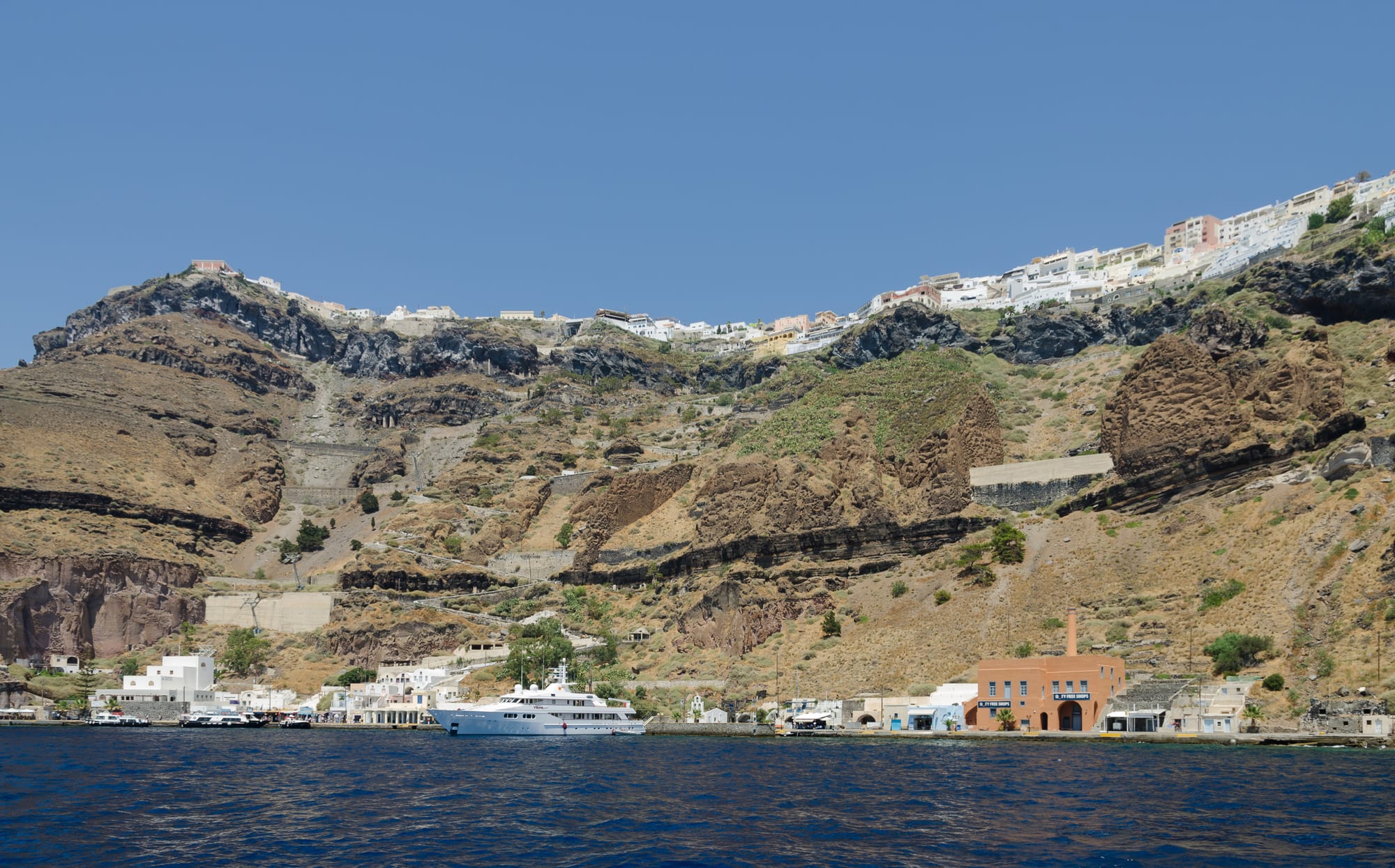
White houses of Fira along the top of brown volcanic cliffs, with the zigzag path and small old port at the water's edge below

The Cyclades & the Dodecanese, Greece

Santorini

Fira on the caldera rim above its old port, seen from the water. (Norbert Nagel / Wikimedia Commons · CC BY-SA 3.0)

The southernmost of the Cyclades, a volcanic island curved around a flooded caldera, seen from its capital, Fira, whose white houses line the cliff edge high above the old port. A Bronze Age eruption buried the town of Akrotiri; the 1956 earthquake drove many islanders away; today about 15,500 residents host around two million visitors a year, drawn by caldera views, wine and dark beaches.

Neighbourhoods

  • Fira
    • First-time visitors
    • Close to public transport
    • Nightlife

    The capital, a town of whitewashed houses on the caldera edge with views over Nea Kameni and Therasia. The central square, Plateia Theotokopoulou, has the bus station, and the museums, the cathedrals and the cable car to the old port are a short walk away; it stays the liveliest place on the island out of season.

    Open in Maps
  • Firostefani and Imerovigli
    • Caldera views
    • Quiet stays

    The caldera-rim villages just north of Fira, joined to it by paved paths. Imerovigli sits at the highest point of the caldera cliffs, with Skaros Rock and the ruins of its Venetian castle below.

    Open in Maps
  • Oia
    • Sunsets
    • Historic captains' houses

    The village at the island's northern tip, its houses sunk into the volcanic rock above Amoudi Bay. Captains' houses recall the merchant fleet that made it rich around 1900, and crowds gather at dusk for the sunset.

    Open in Maps
  • Kamari
    • Beaches
    • Families

    A coastal village about 8 km from Fira on the south-east coast, built after the 1956 earthquake, along the island's longest beach of black pebbles below Mesa Vouno, with restaurants and cafés along the front.

    Open in Maps
  • Perissa
    • Beaches
    • Budget stays

    A beach village about 13 km south-east of Fira on the other side of Mesa Vouno, where a long dark beach runs on to Perivolos and Agios Georgios; the old church of Saint Irene here gave the island its name.

    Open in Maps
  • Pyrgos
    • Wine
    • Village life

    A hilltop village about 7 km from Fira, built around a Venetian castle, with fewer shops than Fira or Oia and wineries in the surrounding countryside.

    Open in Maps

Things to do

In Fira

  • Museum of Prehistoric Theramuseum

    Finds from Akrotiri and other early sites, including the frescoes and pottery of the Bronze Age town, in a museum built on the site of a church destroyed in 1956.

    Open in Maps
  • Archaeological Museum of Theramuseum

    Built in 1960 near the cable car, with Archaic to Roman pottery and sculpture, much of it from the cemetery of Ancient Thera.

    Open in Maps
  • Three Bells of Firalandmark

    The blue-domed Catholic Church of the Dormition on the cliff edge, known for its three bells and its view over the caldera.

    Open in Maps
  • Cathedral of St John the Baptistlandmark

    The Roman Catholic cathedral in the Catholic quarter of Fira, a Baroque Revival building of 1823 restored after the 1956 earthquake.

    Open in Maps
  • Santorini Cable Car and the old porttransit hub

    The gondola lift from Fira down the caldera cliff to the old port, where cruise passengers come ashore; the alternative is a zigzag path of several hundred steps.

    Open in Maps

Caldera and volcano

  • Fira to Oia pathtrail

    The path along the caldera rim from Fira through Firostefani and Imerovigli to Oia, with steep climbs, rocky stretches and unprotected drops; best in spring.

    Open in Maps
  • Skarosviewpoint

    A rock headland below Imerovigli crowned by the ruins of a Venetian castle built in 1207, once the island's main stronghold.

    Open in Maps
  • Nea Kameniattraction

    The uninhabited volcanic island in the middle of the caldera, last active in 1950, where boats land visitors to climb a gravel path to the rim of its crater.

    Open in Maps

Around the island

  • Akrotiriattraction

    The Bronze Age town buried by the eruption in the 16th century BC, excavated since 1967 under a protective roof, with streets, multi-storey houses and early drainage.

    Open in Maps
  • Ancient Theraattraction

    The ruins of the city founded in the 9th century BC on the limestone ridge of Mesa Vouno, reached by a winding road from Kamari or by footpaths.

    Open in Maps
  • Red Beachbeach

    A popular beach of red and black volcanic sand, coloured by oxidised iron, reached from nearby Akrotiri; landslides have made parts of it inaccessible since 2013.

    Open in Maps
  • Kamari Beachbeach

    The longest beach on the island, of black pebbles, running from Monolithos to the foot of Mesa Vouno.

    Open in Maps

Seasonal events

  • Epiphany at KamariJanuary

    The Blessing of the Waters is held each year at the old customs-house arch at the south end of Kamari beach.

Eat and drink

Long-standing places and food districts in Santorini. Hours, ratings and directions come from your maps app, always current.

Santorini classics

  • Fira's caldera-edge restaurantsneighborhood

    The lanes of Fira along the cliff top hold the island's largest choice of tavernas, cafés and bars, a dozen or more of them open all year.

    Open in Maps
  • Wineries of Pyrgos and Megalochorineighborhood

    Wineries in the villages of the south and centre offer tours and tastings of Assyrtiko whites and sweet Vinsanto.

    Open in Maps
  • Kamari seafrontneighborhood

    Restaurants and cafés along the black-pebble beach of Kamari, a more relaxed alternative to the caldera villages.

    Open in Maps

Experience Santorini

History

Santorini's story is shaped by its volcano. Around 3,600 years ago one of the largest volcanic eruptions of the past 5,000 years blew apart the island, leaving the water-filled caldera and burying the Bronze Age port town of Akrotiri under ash, which preserved its frescoes and multi-storey houses. The eruption has been linked to the legend of Atlantis. In the 9th century BC Dorian settlers built a city on Mesa Vouno, now called Ancient Thera; colonists from the island later founded Cyrene in North Africa, and under the Ptolemies Thera was a naval base.

The name Santorini, after Saint Irene, appears in the 12th century. After the Fourth Crusade the island came under the Duchy of Naxos; Marco Sanudo's castle on Skaros dates from 1207, and Venetian rule left a Catholic community and bishopric that survive today. Ottoman rule followed, and by 1810 Santorini had one of the larger Greek merchant fleets. As the castle on Skaros declined, Fira on the caldera edge became the new capital, and the island became part of the Greek state from 1830.

On 9 July 1956 an earthquake and its aftershock killed 53 people on the island and completely destroyed about half its buildings. Many islanders left for Athens. Tourism, begun with yacht cruises in the 1950s, grew to around two million visitors a year; the pumice quarries were closed in 1986 to protect the caldera, and in 2007 the cruise ship Sea Diamond sank inside it. In February 2025 an earthquake swarm led about 6,000 residents to leave by ferry and up to 2,700 by air; a state of emergency lasted until 3 March.

Culture & Customs

The island's look is its signature. Traditional houses are low cubes of local stone, whitewashed or coloured with volcanic ash, and many are hyposkapha, rooms dug sideways or downwards into the pumice that stay cool in summer and warm in winter. Fira's skyline mixes the domes of Orthodox churches with the Catholic cathedral of St John the Baptist and the Three Bells, reminders of the Venetian centuries.

Wine is a cultural inheritance as much as a crop. Vines trained into low baskets against the wind cover the interior, and the island's wines carry their own designations of origin. Religious life follows the Orthodox calendar alongside the Catholic one, and Epiphany is marked at Kamari with the Blessing of the Waters at an old customs-house arch.

Santorini also lives in the world's imagination. Films such as Summer Lovers and The Sisterhood of the Traveling Pants were shot here, a film festival is held each year at the open-air Cinema Kamari, and the caldera has become a favourite backdrop for couples from Asia who come for pre-wedding photographs.

Daily Life

About 15,500 people lived on the island at the 2021 census, far more than the 12,000 or so of the mid-1950s, as tourism brought growth. Fira is the administrative and commercial centre, with the bus station, banks, pharmacies and most of the year-round restaurants.

Tourism is the main industry, with farming and wine making behind it: viticulture is the most important branch of agriculture, and the Santorini tomato is still processed at a factory near Monolithos. Water has always been scarce; old rain cisterns have given way to desalination plants, which supply running but non-potable water to most homes, and electricity comes mainly from the power station at Monolithos. Revenue from the Fira cable car is shared among the island's 14 communities and partly supports the traditional mule drivers.

Success brings strains: in summer the island is overcrowded with cruise passengers and beach-goers, and fresh water must be made by desalination. The 2025 earthquake swarm, and the volcano's continuing restlessness, are part of everyday awareness, with evacuation points marked in every settlement.

Food

Santorini's cooking was shaped by dry volcanic soil and little water. Its best-known dish is fava Santorinis, a smooth purée made from the seeds of Spanish vetchling grown only on Santorini and neighbouring islands, which has a protected designation of origin. The Santorini tomato, a small, deep red cherry tomato with a sweet, strongly acidic taste, is fried into tomatokeftedes, tomato fritters; a museum on the island is devoted to the tomato and its processing.

Wine is the island's pride. Assyrtiko, the indigenous white grape, grows on old, ungrafted vines trained into low baskets and makes extremely dry whites with citrus and mineral flavours; Athiri and Aidani are grown beside it, and Mandilaria and Mavrotragano make reds. Vinsanto, a sweet, strong wine of sun-dried Assyrtiko, Athiri and Aidani grapes, is the island's dessert wine.

Fava and tomato fritters are the dishes to look for on taverna menus; meat dishes are not part of the traditional diet on an island with few livestock. Fira and Oia have the most restaurants with caldera views, Kamari has restaurants along its beach, and wineries around Pyrgos and Megalochori welcome visitors for tastings.

Planning tools

Budget

Santorini is one of the most expensive places in Greece in summer: caldera-edge hotels in Fira, Imerovigli and Oia are the dearest, and restaurants with a caldera view charge 30–50% more than those a street or two back. Rooms in Kamari, Perissa and inland villages are cheaper, and prices fall in spring and autumn. Ferries and a hire car or quad add to the bill.

Daily Budget Midrange
USD 180–350 (mid-range hotel, taverna dinners, boat trip, a hire car or quad for a day or two)
Daily Budget Shoestring
USD 70–110 (room or hostel away from the caldera, gyros and bakery food, buses)

Sleep in Kamari, Perissa or an inland village and visit the caldera by bus; restaurants without posted prices are best avoided.

Best Time to Visit

April to June and September to October are the best months, with milder weather, fewer cruise passengers and lower prices; spring is the time for walking the caldera path. July and August are hot, shadeless and crowded. In winter Fira keeps a dozen or so restaurants open, but smaller villages may have only one or two, and the weather can be grey.

Suggested Number of Days

Two or three days cover Fira, the caldera villages and the main archaeological sites. Four or five allow time for the beaches, the volcano and the wineries; ferry timetables, which change daily, often decide the exact length of a stay.

First Visit
2–3 days
With Surroundings
4–5 days

Transportation

Fira's bus station is the hub of a network that reaches almost every village; crossing from one side of the island to the other means changing in Fira. Services are frequent in high season and sparse in winter. Driving from one end of the island to the other takes about an hour. Hire cars, quads and scooters are widely offered; tour boats visit Nea Kameni, and a ferry links Amoudi below Oia with Therasia.

Check any hired quad or scooter and its insurance carefully before signing; cheap offers can hide poor vehicles and limited cover.

Airport & Station Connections

Santorini International Airport lies about 6 km south-east of Fira, north of Monolithos, with flights from Athens and summer services from much of Europe; buses and taxis run to Fira. Ferries from Piraeus run daily all year and link the island with the rest of the Cyclades, docking at Athinios, about 15 minutes by bus from Fira. Cruise ships anchor in the caldera and land passengers at the old port.

Walkability

Fira is compact and best explored on foot, along cobbled lanes and steps with few cars; a path continues along the rim to Firostefani, Imerovigli and Oia. The many steps are hard for older visitors and children need watching by the low walls above the cliffs. Beaches and wineries are spread out and reached by bus or car.

Safety

Greece is a safe country for visitors, with low levels of violent crime. On Santorini the main risks are quad and scooter accidents on steep roads, crowding on the caldera paths when cruise ships are in, heat and dehydration on an island with little shade, and rockfalls below the cliffs. The island is volcanic and seismically active: an earthquake swarm in early 2025 led thousands of people to leave temporarily, and each settlement now has marked assembly points.

Carry water, keep away from cliff edges and bases, note the nearest earthquake assembly point, and follow official instructions in any emergency. Check current official travel advice before travelling.

Climate

A hot semi-arid climate with Mediterranean traits: dry summers and somewhat wetter winters, about 270 mm of rain a year, falling mostly in winter, and an average annual temperature of around 19°C. The meltemi, the strong, dry north wind of the Aegean, blows from about mid-May to mid-September.

Summer
very hot and dry after May, with an extreme UV index and little shade; the island's year-round average is around 19°C
Winter
cooler, with occasional rain and wind, the wettest season — temperatures rarely fall very low, and the year averages around 19°C

Local Customs

Santorini has both Orthodox and Catholic communities, and churches of both are working places of worship that may ask for covered shoulders and knees. Tipping is not traditional, though diners often leave a few coins for good service. Many photographers gather at the caldera viewpoints.

The use of donkeys to carry visitors up from the old port has been criticised by animal welfare groups; the cable car or the path are the alternatives.

Common Payment Methods

The currency is the euro. Cards are widely accepted in shops, hotels and travel agencies but not in some restaurants, and ATMs are easy to find; bus tickets are sold on board for cash only. Mini markets charge at least 25% more than the supermarkets near Fira and Mesaria.