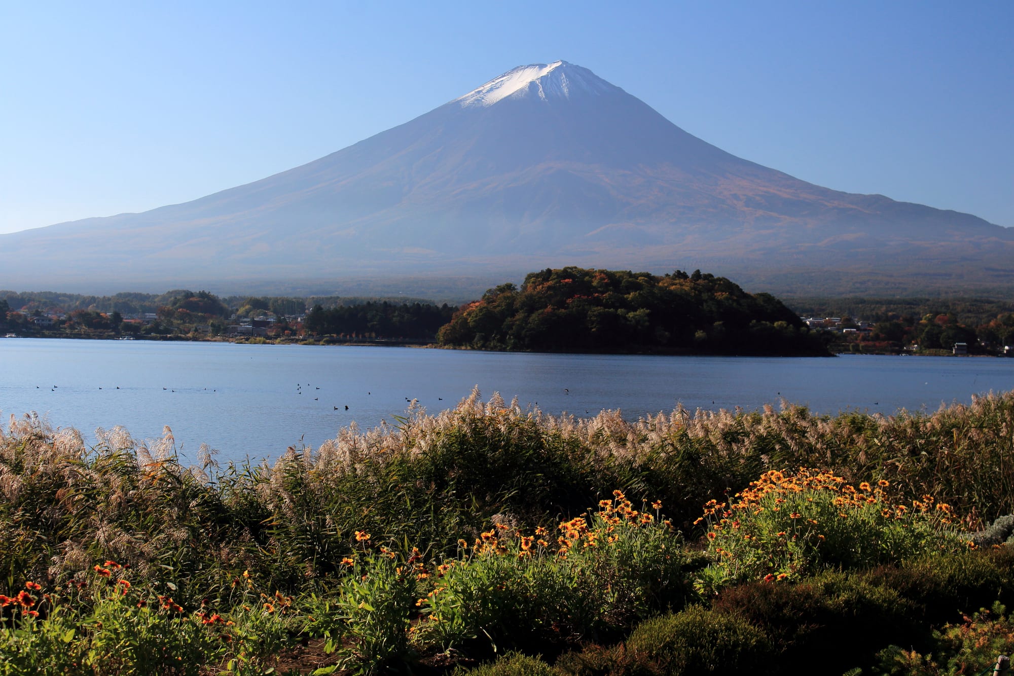
The snow-capped cone of Mount Fuji rising beyond a calm blue lake, with grasses and orange flowers in the foreground

Chubu: the Japanese Alps & Mount Fuji, Japan

Fujikawaguchiko

Mount Fuji seen across Lake Kawaguchi from Oishi Park in Fujikawaguchiko, Yamanashi. (Alpsdake / Wikimedia Commons · CC BY-SA 4.0)

A lakeside town in southern Yamanashi, on a plateau about 850 metres up on the northern side of Mount Fuji. Formed by mergers in 2003 and 2006, it takes in Lake Kawaguchi and several of the Fuji Five Lakes, and serves as the main base for views of the mountain, for the lava caves and forests below it and for transport to the climbing route in summer.

Neighbourhoods

  • Kawaguchiko station and the south shore
    • First-time visitors
    • Close to public transport
    • Best for food

    The busiest part of the town, where buses from Tokyo and the local railway arrive. Hotels, hostels, restaurants and rental bicycles cluster within a few streets of the station, and the lake begins a short walk north.

    Open in Maps
  • The north shore and Oishi Park
    • Mountain views
    • Quiet and residential
    • Walks

    The far side of Lake Kawaguchi, where the mountain stands clear above the water and a lakeside park is planted with lavender and seasonal flowers. Small museums, cafés and inns are spread along the road, with far less traffic than the station side.

    Open in Maps
  • Funatsu and the lakeside hot springs
    • Hot springs
    • Families
    • Waterfront

    The strip between the station and the eastern end of the lake, with larger hotels, hot-spring bathhouses, boat piers and the base station of the ropeway. It is convenient rather than scenic, and busy on summer weekends.

    Open in Maps
  • Saiko and Ashiwada
    • Quiet and residential
    • Nature
    • Camping

    The western part of the town around the smaller Lake Sai, backed by forest and lava caves. Campsites, guesthouses and a reconstructed village of thatched houses replace hotels here, and buses are less frequent.

    Open in Maps

Things to do

The lakes and viewpoints

  • Lake Kawaguchiattraction

    The most accessible of the Fuji Five Lakes, ringed by a road and cycle path, with pleasure boats, fishing and a long north shore that faces the mountain directly.

    Open in Maps
  • Oishi Parkpark

    A lakeside garden on the north shore planted in bands of lavender, kochia and seasonal flowers, giving the classic foreground for a photograph of Mount Fuji.

    Open in Maps
  • Mount Tenjoviewpoint

    A wooded summit above the eastern end of the lake, reached by a short ropeway or on foot, with a terrace looking over the water to the mountain.

    Open in Maps
  • Lake Saiattraction

    A quieter lake west of Kawaguchi, surrounded by forest and campsites, with clear water used for boating and fishing.

    Open in Maps
  • Lake Shōjiattraction

    The smallest of the Fuji Five Lakes, west of the town, known for a view in which a lower ridge appears to cradle the mountain.

    Open in Maps

Woods, caves and shrines

  • Aokigaharatrail

    The dense forest that grew on lava flows west of the town, with marked walking trails, thin soil, twisted tree roots and almost no undergrowth.

    Open in Maps
  • Narusawa Ice Caveattraction

    A lava tube in the Aokigahara forest that stays near freezing all year and was long used as a natural refrigerator, its ice carried to Edo for the shogun; visitors stoop through a low, slippery passage.

    Open in Maps
  • Fugaku Wind Caveattraction

    The largest of the lava tubes in the Aokigahara forest, cold enough to have served as a natural store, entered on a short circular path.

    Open in Maps
  • Kawaguchi Asama Shrinelandmark

    An old shrine founded to placate Mount Fuji after an eruption, approached through a corridor of tall cedars, with a hillside lookout above it.

    Open in Maps

Museums

  • Itchiku Kubota Art Museummuseum

    A museum on the north shore for the dyed kimono of Itchiku Kubota, whose large works form continuous landscapes, in buildings of coral stone and timber among gardens.

    Open in Maps
  • Kawaguchiko Music Forestmuseum

    A lakeside museum of mechanical music — fairground organs, automata and music boxes — set in European-style gardens with the mountain behind.

    Open in Maps

Short trips from the town

  • Mount Fujiviewpoint

    Japan's highest mountain at 3,776 metres, a UNESCO World Heritage Site; a toll road climbs from the town to the fifth station, the start of the northern climbing route in the summer season.

    Open in Maps
  • Chūreitōlandmark

    A five-storeyed pagoda on a hillside above neighbouring Fujiyoshida, reached by a long stair, and set with cherry trees in a view of the mountain that is one of the most photographed in Japan.

    Open in Maps
  • Oshino Hakkaiattraction

    Eight clear pools in a village about 10 kilometres east, fed by snowmelt filtered through the mountain, among thatched houses and craft stalls.

    Open in Maps
  • Fuji-Q Highlandattraction

    An amusement park just east of the town known for roller coasters that have held world records, with the mountain in view from the rides.

    Open in Maps

Seasonal events

  • Moss phlox in flowermid-April to late May

    Slopes in the west of the town are planted with moss phlox in pink and white bands below the mountain, and shuttle buses run out to them from the station.

  • Lavender seasonlate June to July

    Lavender comes into flower at the lakeside parks, above all at Oishi Park on the north shore, where the purple beds sit under the mountain.

  • Autumn colour by the lakeNovember

    The maples along the lakeside avenues and the roads below the mountain turn red and gold, the busiest walking season of the year.

  • Clear winter morningsJanuary and February

    The coldest weeks bring the cleanest air of the year, with the mountain fully snow-covered and often visible from first light.

Eat and drink

Long-standing places and food districts in Fujikawaguchiko. Hours, ratings and directions come from your maps app, always current.

Yamanashi classics

  • Hotorestaurant

    The dish of the prefecture, made with flat wheat noodles stewed with pumpkin, mushrooms and root vegetables in miso broth, served in an iron pot at several long-standing restaurants in the town.

    Open in Maps
  • Yoshida udonrestaurant

    Unusually firm, chewy udon from neighbouring Fujiyoshida, served with horse meat or cabbage and a chilli and sesame condiment, a working lunch dish of the old weaving town.

    Open in Maps
  • Lake fishrestaurant

    Wakasagi smelt, fried whole, and grilled trout from the lakes and the spring-fed streams appear on menus around the shore.

    Open in Maps

Where to eat and drink

  • The station streetsneighborhood

    Most of the town's restaurants, cafés, bakeries and convenience stores stand within a few minutes of the station, including noodle houses and grills used by residents.

    Open in Maps
  • Yamanashi wineneighborhood

    Yamanashi is Japan's main wine-producing prefecture, and shops and restaurants in the town pour local wines made from the white Koshu grape alongside sake and craft beer.

    Open in Maps

Experience Fujikawaguchiko

History

The land here is young. Mount Fuji's eruptions built the plateau, and the lava flows of the Jogan eruption of 864 to 868 split a larger lake into the present Lake Sai, Lake Shoji and Lake Motosu and spread the ground on which the Aokigahara forest later grew. The Kawaguchi Asama Shrine at the lake was founded in the wake of that eruption to calm the mountain, and shrines of the same family ring the whole volcano.

For centuries the settlements were small farming and forestry villages on poor volcanic soil, made busier in the Edo period by the Fuji-ko, confraternities of pilgrims from Edo who crossed the passes to climb the mountain in summer and lodged at pilgrims' houses on the way. Silk and weaving supported the area around Yoshida to the east, and boats carried goods across the lakes.

Modern tourism arrived with transport: the Fujikyuko railway reached Kawaguchiko in 1950, a toll road to the fifth station opened in the 1960s, and hotels, museums and camps spread along the shores through the postwar decades. The town in its present form is recent, created in 2003 by the merger of Kawaguchiko, Ashiwada and Katsuyama, and enlarged in 2006 by the addition of Kamikuishiki. The inscription of Mount Fuji as a UNESCO World Heritage Site in 2013 — as a cultural site, for its place in religion and art — raised visitor numbers sharply, and managing them has shaped local policy ever since.

Culture & Customs

Everything here refers to the mountain. It has been an object of worship for well over a thousand years, first feared for its eruptions and later climbed as an act of devotion; the Asama shrines, the stone markers along the old trails and the pilgrim lodgings of the Fuji-ko are the physical remains of that faith, and the mountain's presence in woodblock prints, above all Hokusai's series of views, made it the national emblem it remains.

Local culture is that of a highland farming and forestry district turned resort. Village festivals at the shrines keep their processions and dances, silk weaving survives in the area as a craft, and the seasonal calendar of flower plantings, lake fireworks and maple lighting is a modern layer over it. Photography is itself a local activity: the shore fills before dawn when the forecast is clear, and residents are long used to cameras pointed over their fences.

The relationship with visitors is the current theme. Several million people a year pass through a town of some ten thousand households, and measures to control parking, litter, roadside crowds and the numbers climbing the mountain in summer have become part of daily life. Ordinary manners are those of rural Japan: greetings between neighbours, quiet evenings, and a strong sense that the landscape is lived in rather than staged.

Daily Life

About 26,000 people live in the town, spread among the settlements around the lakes rather than in one centre. Tourism is the economy — hotels, guesthouses, campsites, restaurants, bus and boat operators, souvenir and craft shops — and it is highly seasonal, with a long quiet stretch in late winter and early spring and a rush from the flower festivals through to the autumn colour.

Farming continues on the plateau, with vegetables suited to cool summers, and forestry and stone quarrying survive on a small scale. Many residents work in neighbouring Fujiyoshida, which has the area's hospital, shops and remnants of its textile industry, and commuting to Kofu or even Tokyo is possible if slow. Young people leaving for the cities has thinned the population, as across rural Yamanashi.

Life is shaped by altitude and weather. Winter mornings are well below freezing, snow closes the mountain roads, and water from the volcano's springs is so abundant that the town is known for the clarity of its tap water. Residents watch the mountain the way other places watch the sea — for cloud, for the first snow in autumn and the last in summer. Traffic on the lakeside roads at peak times, the price of housing pushed up by holiday accommodation and preparation for volcanic emergencies are the standing local issues.

Food

Yamanashi's dish is hoto, and it is served across the town in heavy iron pots: broad, flat wheat noodles simmered, not boiled separately, with pumpkin, taro, mushrooms and greens in a miso broth, so that the starch thickens the soup. It was farmhouse food in a province too mountainous for much rice, and it suits the cold evenings of the plateau.

Close by, Fujiyoshida has Yoshida no udon, a distinctly hard, chewy noodle in a soy and miso broth, topped with boiled cabbage, fried tofu and sometimes horse meat, eaten with a chilli-and-sesame condiment called suridane. The lakes and spring-fed streams supply wakasagi smelt, fried whole in batter, and rainbow trout and char, grilled on skewers. Water is a speciality in its own right: the snowmelt filtered through the volcano's lava for decades is bottled commercially and used by soba makers, brewers and tofu shops.

Yamanashi is also Japan's leading wine prefecture and a large grower of grapes, peaches and plums, so local wine made from the white Koshu grape and summer fruit appear on menus and in shops, though the vineyards themselves lie north around Katsunuma. Sweets lean on the mountain in shape and name — steamed buns, bean cakes and rice crackers moulded or printed as Fuji — and roadside stalls sell grilled rice cakes, corn and chestnuts in season.

Planning tools

Budget

Accommodation is the main cost and varies widely, from hostels near the station to lakeside hotels with hot springs and mountain views, which are priced accordingly. Rates rise sharply at weekends, during the flower festivals and in the climbing season. Buses, museum entry and the ropeway are inexpensive, and the best views cost nothing.

Daily Budget Midrange
USD 120–230 (lakeside hotel or ryokan with dinner, restaurant meals, ropeway and museum entry, taxis)
Daily Budget Shoestring
USD 55–95 (hostel or guesthouse, noodle meals and convenience stores, local buses)

Rooms facing the mountain cost considerably more than those facing the hill behind, and a two-day bus pass covers the lake loops and the Shibazakura shuttle.

Best Time to Visit

Autumn and winter give the clearest sightings of the mountain, when dry air and snow cover make it visible most mornings; November adds maple colour and January the sharpest views. April and May bring blossom and the moss phlox, and July and August the lavender and the climbing season, though summer often hides the peak behind cloud from mid-morning.

Suggested Number of Days

One night is enough to see the lake and wait for a clear morning, which is how most visitors come. Two or three suit walkers, the caves and the other lakes, or anyone planning to climb in the summer season.

First Visit
1–2 days
With Surroundings
3 days

Transportation

Two retro-styled sightseeing bus lines loop around the lakes from Kawaguchiko station, one along Lake Kawaguchi and one out to Lake Sai and the caves, with fixed stops at the parks and museums. Buses also climb the toll road to the fifth station in season. Bicycles and electric bikes are rented near the station, the lake circuit being about twenty kilometres, and many visitors drive.

Sightseeing buses can fill at peak times and the timetable thins in winter, so check the last departure before setting off around the lake.

Airport & Station Connections

Express coaches from Shinjuku in Tokyo reach the town in about two hours and are the simplest route. By rail, JR trains run from Shinjuku to Otsuki, where the Fujikyuko line continues to Kawaguchiko in about 50 minutes, with some through services. Drivers use the Chuo Expressway to the Kawaguchiko interchange. The nearest Shinkansen station is Mishima, with a bus over the mountains.

Walkability

The streets around the station are walkable and the eastern shore is an easy stroll, but the town is spread along some 20 kilometres of lakeshore and the best viewpoints are several kilometres from the centre. Buses, bicycles or a car are needed to reach the north shore, the caves and the other lakes. Footpaths beside the lake are flat; the forest and hill trails are rough in places.

Safety

Crime is very low. The risks are of the mountain kind: cold and altitude on Mount Fuji, which should be climbed only during the official summer season and with proper clothing, icy roads and paths in winter, black bears in the forest, and the fact that Fuji is an active volcano with monitoring and evacuation planning in place.

Climb only in season with warm layers and rain gear, keep to marked trails in the lava forest where a compass can read oddly and the ground is uneven, and follow official notices on volcanic activity and road closures. Check current official travel advice before travelling.

Climate

A highland climate several degrees cooler than Tokyo, with wide differences between day and night. Summer is mild but often cloudy around the mountain, the rainy season falls in June and early July, and winter is cold, dry and clear, with snow on the ground and a frozen edge to the smaller lakes.

Summer
mild — days of 25–28°C with cool nights, frequent cloud and afternoon thunderstorms
Winter
cold and clear — days of 3–8°C, nights well below freezing, with occasional heavy snowfalls

Local Customs

This is a working town as well as a resort, and much of the famous scenery is seen from residential streets, private drives and farmland. Visitors are asked to keep off private land, not to block pavements or roads while photographing, and to take rubbish away. Bathing rules in the hot springs follow the national pattern of washing before entering the water.

Park only in marked car parks, do not stand in the road for a photograph, and keep noise down in the lakeside residential areas early in the morning.

Common Payment Methods

The currency is the Japanese yen. Hotels, larger restaurants, buses and convenience stores take cards or IC payment, but small guesthouses, craft stalls, campsites and some cave and boat tickets are cash only. Cash machines at convenience stores and the post office accept foreign cards.