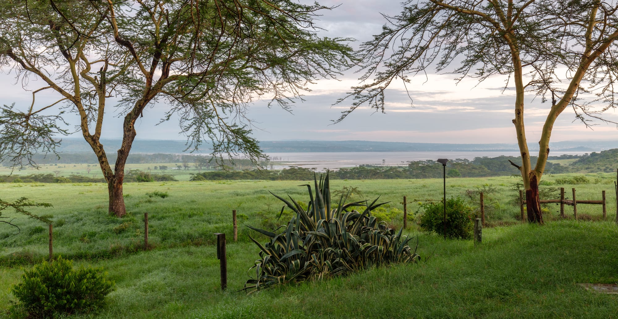
Flat-topped acacia trees over green grassland, with the pale water of a shallow lake and low wooded hills beyond

The Maasai Mara & the Rift Valley, Kenya

Nakuru

Lake Nakuru and its national park, on the southern edge of the city. (Diego Delso / Wikimedia Commons · CC BY-SA 4.0)

The largest city on the floor of Kenya's Rift Valley, built by the Uganda Railway among settler farms and now a fast-growing commercial centre of more than half a million people. A soda lake and its national park lie on the southern edge of the built-up area, and the vast Menengai caldera rises immediately to the north.

Neighbourhoods

  • Town centre
    • First-time visitors
    • Markets
    • Close to transport

    The grid of streets around Kenyatta Avenue laid out beside the railway, with the main market, banks, hotels, bus and matatu stages and the older shopfronts of the railway town. Busy, walkable and the practical base for most visitors.

    Open in Maps
  • Milimani
    • Quiet and residential
    • Hotels

    The leafy residential quarter on rising ground south of the centre, built for colonial officials and settlers and still the address for larger houses, guesthouses and offices. Close to the park gate and much calmer than the centre.

    Open in Maps
  • Section 58 and Nakuru West
    • Local life
    • Value

    Dense residential estates west and north-west of the centre, where much of the city lives. Small shops, eating places, churches and markets line the main roads, and matatus run in constantly.

    Open in Maps
  • The Menengai side
    • Views
    • Quiet

    North of the city the ground climbs towards the rim of the Menengai caldera, past newer housing. Cooler air, long views back over the city and the lake, and the starting point for walks on the crater.

    Open in Maps
  • Lanet and the Nairobi road
    • Close to transport

    The eastern approach along the highway from Nairobi, with an army barracks, an airstrip, petrol stations, lorry stops and spreading suburbs. Convenient for arriving and leaving rather than for sightseeing.

    Open in Maps

Things to do

The lake and the park

  • Lake Nakuru National Parkpark

    A fenced park around the soda lake on the city's southern edge, holding black and white rhino, Rothschild's giraffe, lions and waterbuck; the lake's flamingo flocks vary greatly with water levels.

    Open in Maps
  • Baboon Cliffviewpoint

    The escarpment viewpoints on the park's western side look down over the whole lake, its pale soda shoreline and the drowned acacia woodland left by rising water.

    Open in Maps

Craters and viewpoints

  • Menengaiviewpoint

    The largest volcanic caldera in Kenya, a shield volcano immediately north of the city whose 12 by 8 km caldera formed about 8,000 years ago; the floor below the rim is a mass of lava flows, and a geothermal power field is being developed on it.

    Open in Maps

Prehistory and history

  • Hyrax Hillmuseum

    A prehistoric site on the eastern edge of the city, found by Louis Leakey in 1926 and first excavated by Mary Leakey in 1937–38, with Pastoral Neolithic and Iron Age settlement remains, Sirikwa holes and a site museum.

    Open in Maps
  • Lord Egerton Castlelandmark

    A house built like a fortress west of the city, begun in 1938 by Maurice Egerton, 4th Baron Egerton, worked on until 1954 and open to the public since 2005 under Egerton University.

    Open in Maps
  • Egerton Universityattraction

    Kenya's oldest institution of higher education, founded at Njoro in 1939 as Egerton Farm School and now a public university with wooded grounds.

    Open in Maps

Short trips from the city

  • Lake Elmenteitaattraction

    A shallow soda lake with pelican breeding islands and flamingos, part of the UNESCO-listed Kenya Lake System of the Great Rift Valley.

    Open in Maps
  • Soysambu Conservancypark

    A conservancy created in 2007 on the Delamere family's Soysambu ranch, wrapping round the shores of Lake Elmenteita; Rothschild's giraffe were brought here from Lake Nakuru, and the lake holds the last pelican breeding site in Kenya.

    Open in Maps
  • Kariandusi prehistoric sitemuseum

    An Acheulean site excavated by Louis Leakey in the 1920s, where hand-axes and obsidian tools lie in place in the exposed lake-bed deposits.

    Open in Maps
  • Lake Bogoriaattraction

    A hot, saline lake in a national reserve with geysers and boiling springs along its shore and, at times, very large flocks of lesser flamingos.

    Open in Maps
  • Thomson's Fallsattraction

    A waterfall of about 74 metres on the Ewaso Ng'iro river, surrounded by cold highland forest at the edge of Nyahururu town.

    Open in Maps

Eat and drink

Long-standing places and food districts in Nakuru. Hours, ratings and directions come from your maps app, always current.

Nakuru classics

  • Nyama choma barsrestaurant

    Goat and beef roasted over charcoal, ordered by weight, chopped on a board and eaten with ugali and kachumbari — the city's standard evening meal out.

    Open in Maps
  • Town-centre caféscafe

    Old-fashioned railway-town cafés and newer coffee shops along and around Kenyatta Avenue, serving chai, mandazi, samosas and cooked breakfasts.

    Open in Maps

Markets and street food

  • Nakuru main marketmarket

    The city's central produce market, stocked with maize, potatoes, kale, tomatoes and fruit from the farms of the surrounding highlands.

    Open in Maps
  • Wakulima and the roadside stallsmarket

    The wholesale farmers' market and the stalls around it, where traders buy in bulk and street kitchens sell roast maize, boiled eggs and mutura in the evenings.

    Open in Maps

Experience Nakuru

History

The land around the lake was Maasai grazing country, and the name comes from a Maasai word. Nakuru as a town dates from the Uganda Railway, which reached the valley floor at the turn of the twentieth century and made the site a station, a repair point and a market for the farms being laid out across the newly opened highlands. Long before that, people lived on the same ground: Hyrax Hill, on the city's eastern edge, holds Neolithic and Iron Age settlement first excavated by Mary Leakey in 1937–38. A township was proclaimed beside the railway station in 1904.

Settler farming built the town. Wheat, maize, pyrethrum and cattle came down from the Mau and the Bahati escarpments, and Nakuru became the social and commercial capital of the White Highlands, its hotels and clubs serving the farms around it; Lord Delamere's Soysambu ranch, established in 1906, lay a short way down the valley. After independence the settler farms were bought out and subdivided, and Nakuru became the headquarters of Rift Valley Province and the biggest urban centre between Nairobi and the Ugandan border.

Its recent history has been mixed. The city grew fast as land subdivision, trade and industry drew people in, but the questions of land left by the colonial period fed conflict, and Nakuru saw killings and mass displacement during the post-election violence of 2007–08. Lake Nakuru's rise from about 2010 flooded park infrastructure and shoreline land and changed the lake's chemistry, thinning the flamingo flocks it had been famous for. On 1 December 2021 Nakuru was granted a city charter.

Culture & Customs

Nakuru's defining characteristic is that almost everyone here came from somewhere else within Kenya. The subdivision of settler farms after independence brought Kikuyu buyers into a Kalenjin and Maasai region, and later migration added Luhya, Luo, Kisii and Kamba communities, so the city is one of the most ethnically mixed in the country and Swahili is the common language of its streets. That mixture gives the city its energy and also its political tension, since the arguments about who belongs on Rift Valley land run through local politics.

Church life is central — Protestant, Catholic and Pentecostal congregations fill the weekends, and gospel music is heard everywhere. Farming sets the public calendar as much as anything else, and trading days bring growers and herders in from across the surrounding country. Football is followed keenly, and athletics has deep roots: the escarpments around the city are training country, and the region's running culture is a matter of local pride.

Daily manners are ordinary Kenyan ones: greet first and ask after family before business, address older people with respect, dress modestly in town. Matatu culture is strong here, with painted and sound-systemed minibuses working the estate routes. The lake and the crater are part of civic identity as much as they are attractions, and the falling flamingo numbers are discussed locally as a loss rather than a statistic.

Daily Life

Nakuru had an urban population of 570,674 at the 2019 census, making it one of Kenya's largest urban areas, and it has grown further since. People live in estates spreading west and north from the old railway grid — Section 58, Nakuru West, Bahati, Lanet and many newer developments — while Milimani keeps the larger houses of the old colonial quarter.

The economy is built on agriculture and what it feeds: grain milling, food processing, agrochemicals, blanket and textile manufacture, transport and a large wholesale and retail trade serving the whole central Rift. Farms around the city grow maize, wheat, potatoes, vegetables and pyrethrum, and dairy is important on the higher ground. Geothermal drilling at Menengai adds an energy industry on the city's northern doorstep, and tourism runs through the park.

Days begin early, with matatus and lorries on the move before six, and the centre empties quickly after dark. The pressures are those of rapid growth: traffic on the highway that runs straight through the city, water supply, drainage and housing, and the flooding along the lake shore that has displaced families and closed roads since the water began rising. Land ownership and boundary questions remain politically charged.

Food

Nakuru eats the food of the highlands. Ugali, stiff maize meal, with sukuma wiki, braised collard greens, and a stew of beef, goat or beans is the everyday plate. Githeri, maize and beans boiled together, and mukimo, a mash of potato, maize, peas and greens that takes its colour from the leaves, come from Kikuyu kitchens and are standard here. Chapati, thick and oil-fried, accompanies most things.

Nyama choma is the social meal: goat or beef roasted over charcoal, bought by weight at butcheries and bars, chopped on a wooden board and eaten with kachumbari, the raw tomato and onion salad. Mutura, a grilled sausage made with blood and offal, is sold from evening stalls, as is roast maize dusted with chilli and lime. Kalenjin families keep mursik, milk fermented in a charcoal-lined gourd, which is sold in markets around the city.

Chai, boiled with milk and sugar, is drunk through the day, with tea from Kericho and Nandi a few hours west, and mandazi, lightly sweet fried dough, is the usual accompaniment. The markets are stocked from the surrounding farms — potatoes, cabbages, carrots, kale and maize — and tilapia from the Rift lakes is fried and sold at roadside stalls along the highway.

Planning tools

Budget

Nakuru is an inexpensive city by Kenyan standards, with plenty of budget hotels, cheap eating places and short matatu fares. The costs that add up are park entry to Lake Nakuru National Park, charged per person per day, and vehicle hire, since the park cannot be entered on foot.

Daily Budget Midrange
USD 120–270 (a good hotel or a lodge near the park, restaurant meals, park entry and a hired vehicle for game drives)
Daily Budget Shoestring
USD 30–60 (guesthouse, local food, matatus and boda-bodas)

Sharing a hired vehicle with other visitors brings the cost of a park visit down sharply, and hotels in the city centre cost far less than lodges inside the park.

Best Time to Visit

June to October and January to February are dry and the easiest for game drives and for walking on Menengai. Birdlife around the lakes is strongest after rain, so the months following the long rains of March to May can be good for flamingos and pelicans, though tracks in the park are muddier then.

Suggested Number of Days

One or two days covers the city and its park. Three or four allow the other Rift lakes, the prehistoric sites and the crater as well. Many visitors stop here for a single night while travelling between Nairobi and western Kenya.

First Visit
1–2 days
With Surroundings
3–4 days

Transportation

Matatus and buses run constantly to Nairobi, Naivasha, Eldoret, Kericho and Kisumu from stages around the centre, and local matatus and boda-boda motorcycles cover the estates. Taxis and app-based cars work in the city. The national park and the outlying sites need a hired vehicle or a tour.

The main highway through the city carries heavy lorry traffic between Nairobi and the west, and the section over the escarpments is best travelled in daylight.

Airport & Station Connections

Nakuru lies about 160 km north-west of Nairobi on the main highway to western Kenya and Uganda, usually two and a half to three hours by road, with frequent buses and matatus. It sits on the old Uganda Railway line, and an airstrip at Lanet on the eastern edge of the city handles light aircraft rather than scheduled services.

Walkability

The centre is flat, compact and built on a grid, so the market, the bus stages, the shops and most hotels are within a short walk of one another. Pavements are crowded and traffic is heavy at the main junctions. Beyond the centre the city spreads widely, and the park gates, Menengai and Hyrax Hill all need transport.

Safety

Nakuru is a busy commercial city with the crime patterns that go with it: pickpocketing and bag snatching around the market and the matatu stages, and a greater risk of robbery walking alone at night or in quiet streets away from the centre. The city was a centre of the post-election violence of 2007–08, and political demonstrations can bring disruption. Wildlife inside the national park is a hazard only to those who leave their vehicle.

Avoid the northeastern counties and the immediate Somali border, take care in Nairobi's central and eastern districts and after dark, use hotel or app-based transport, and take malaria precautions outside the highlands. Use a taxi rather than walking after dark, keep valuables out of sight in the market, and stay in the vehicle in the park unless at a marked viewpoint. Check current official travel advice before travelling.

Climate

At about 1,850 metres the city is warm by day and cool at night all year, with two rainy periods — the long rains from March to May and shorter rains around October and November — and a dusty, bright dry season in between.

Summer
January to March is the warmest and driest stretch, with days around 27–29°C
Winter
June to August is cooler and often overcast, with days near 24°C and nights around 10°C

Local Customs

Nakuru is a mixed city, with a Kikuyu majority and large Kalenjin, Luhya, Luo and Kisii communities, and that mixture carries political weight in a county whose land history is contested. Swahili is the everyday language, English is used in business, greetings come before any transaction, and churches fill on Sundays.

Ask before photographing people or market stalls, avoid photographing police, the barracks at Lanet and government buildings, and keep away from political gatherings and demonstrations.

Common Payment Methods

The currency is the Kenyan shilling. Mobile money is used for nearly every small payment, including matatu and boda-boda fares and market purchases, and banks and ATMs are plentiful in the centre. Hotels, supermarkets and park gates take cards; small traders expect cash or mobile money.