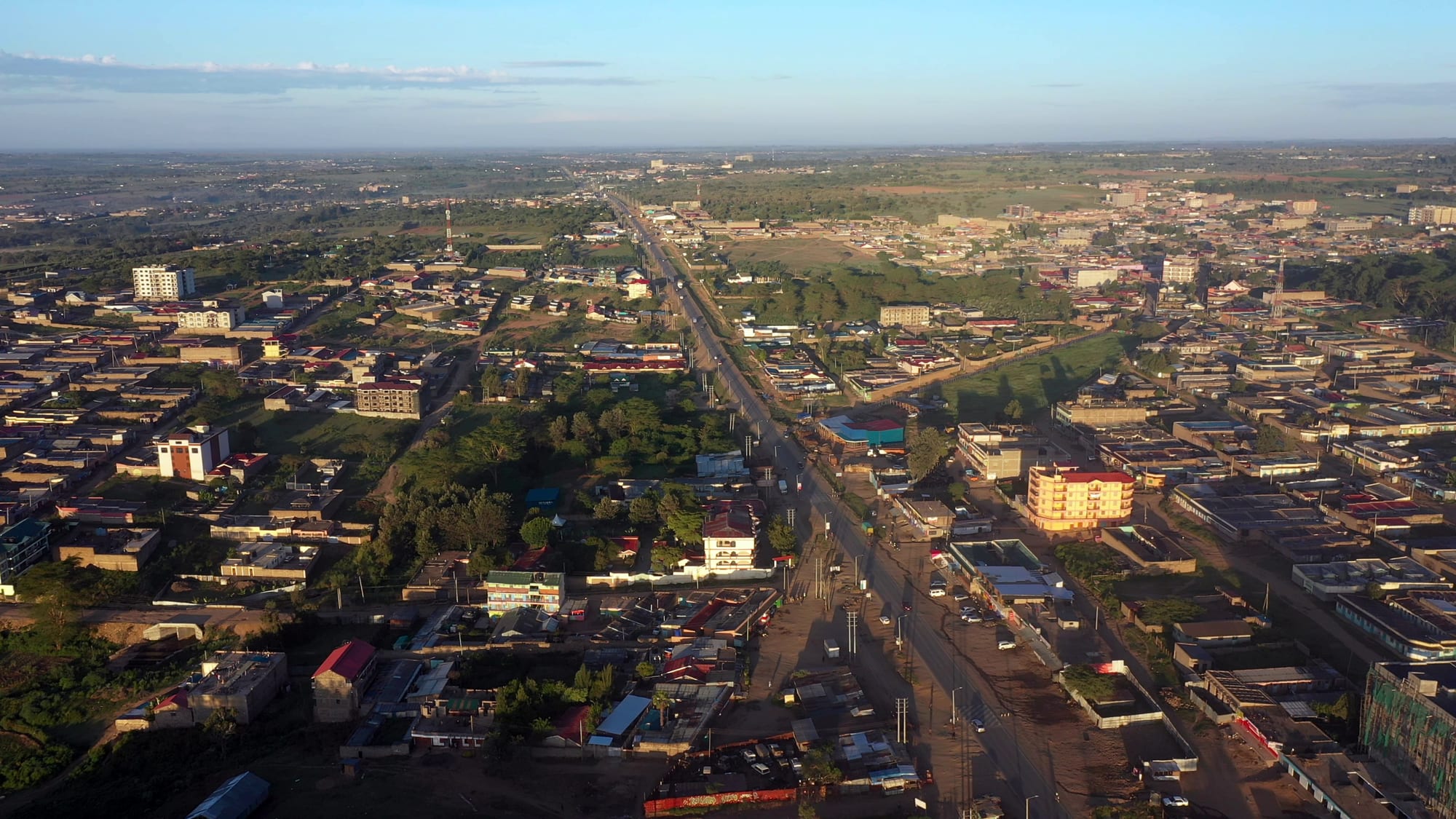
Aerial view of a low-rise African town spread along a straight main road, with green fields and open country beyond

The Maasai Mara & the Rift Valley, Kenya

Narok

Narok town from the air, strung along the highway that carries traffic west towards the Maasai Mara. (Tish Madesh / Wikimedia Commons · CC0)

A Maasai market and administrative town on the highway west from Nairobi, spread along the road at the southern foot of the Mau escarpment. Narok is the headquarters of Narok County and the main road gateway to the Maasai Mara, and its streets mix cattle trading, wheat farming and a constant stream of safari vehicles.

Neighbourhoods

  • The town centre and the highway strip
    • First-time visitors
    • Best for food
    • Close to transport

    Almost everything in Narok stands along or just off the main road: banks, petrol stations, shops selling safari supplies, matatu and bus stages, and the cafés where drivers stop. It is busy, dusty and easy to cross on foot.

    Open in Maps
  • The market quarter
    • Markets
    • Local life

    The open-air market and the streets of small traders behind the main road, where produce from the surrounding farms, secondhand clothes and Maasai beadwork are sold. Market days draw people in from a wide area of the county.

    Open in Maps
  • The university and the western edge
    • Quiet and residential
    • Students

    Newer housing, hostels and small eating places spread out on the side of town towards the Mara road, around the campus of Maasai Mara University. It is quieter than the centre and closer to open country.

    Open in Maps

Things to do

In and around the town

  • Maasai Mara Universityattraction

    A public university on the edge of town, raised to full university status in 2013, which has given Narok a student population and a campus quarter.

    Open in Maps

Short trips from the town

  • Mau Escarpmentviewpoint

    The long western wall of the Rift, its slopes planted with wheat and barley and topped by the Mau forest.

    Open in Maps
  • Maasai Mara National Reservepark

    Kenya's best-known reserve, a stretch of grassland and riverine woodland holding lions, elephants and, from about July to October, the wildebeest crossings of the Mara River.

    Open in Maps
  • Mount Suswaviewpoint

    A shield volcano with a double crater and a system of lava caves formed in its flanks, reached by rough track from the valley floor.

    Open in Maps
  • Mau Forestpark

    The largest block of indigenous montane forest in East Africa and the water tower whose rivers include the Mara, the Sondu and the southern Ewaso Ng'iro.

    Open in Maps
  • Loita Hillsviewpoint

    Forested highlands south of the town, the traditional land of the Maasai and still grazed rather than given over to wildlife tourism; the forest at their heart is known locally as the Forest of the Lost Child.

    Open in Maps

Eat and drink

Long-standing places and food districts in Narok. Hours, ratings and directions come from your maps app, always current.

Narok classics

  • Nyama choma grills on the main roadrestaurant

    Goat and beef roasted over charcoal and cut up on a board, eaten with kachumbari salad and ugali — the standard shared meal in a town where livestock is the local economy.

    Open in Maps
  • Highway cafés and chapati kitchenscafe

    The small kitchens along the highway feed drivers and safari crews with chapati, beans, githeri, stew and strong milky chai through the day.

    Open in Maps

Markets

  • Narok open-air marketmarket

    Vegetables, maize, potatoes and greens from the escarpment farms, alongside secondhand clothes, household goods and Maasai beadwork.

    Open in Maps

Experience Narok

History

The town takes its name from the Enkare Narok, the stream that runs through it, and the country around it has been Maasai grazing land for generations. The Anglo-Maasai treaties of 1904 and 1911 moved communities out of the central Rift and then out of Laikipia into a southern reserve covering what is now Narok and Kajiado counties, and Narok grew as the administrative centre of that southern Maasai country — a colonial district station with a handful of trading dukas at a crossing point on the road west.

Two things enlarged it in the twentieth century. The first was farming: as the slopes of the Mau escarpment above the town were cleared, wheat and barley became a serious crop on the plateau, and Narok became the place where that grain was traded and trucked. The second was the Maasai Mara, gazetted as a reserve in the 1960s and by the 1980s a fixture of international safari itineraries, which turned the road through Narok into the main land route to the reserve gates.

Devolution in 2013 made Narok the headquarters of Narok County, adding county offices, staff and money to a town that had been a rural service centre, and Maasai Mara University was raised to full university status in the same year. Growth since then has been rapid and largely unplanned, spreading the town along the highway and up the slopes behind it, while arguments over land, over revenue from the reserve and over the clearing of the Mau forest have run through county politics.

Culture & Customs

Narok is the urban face of Maasai Kenya. The people of the surrounding rangelands are largely Maasai, and the town is where they come to sell cattle, buy supplies, attend school and appear in court, so red cloth and heavy beaded collars are seen on the main street beside suits and school uniforms. Age-sets still structure Maasai life in the county, cattle remain the measure of wealth, and bride wealth and grazing rights are live social questions rather than heritage.

It is also a mixed town. Kipsigis and other Kalenjin farmers from the escarpment, Kikuyu traders and people from across Kenya run shops, transport businesses and hotels, and the university has added students from everywhere. Swahili is the common language of the street, with Maa spoken at home by many and English in offices and classrooms. Christian churches are numerous and well attended, and Sunday changes the rhythm of the town.

Tourism shapes local identity in complicated ways. Many families earn from the reserve — as guides, drivers, camp staff or through conservancy leases on family land — and cultural performance for visitors is a real business. That coexists with impatience at being treated as a spectacle, and photography of people is something to ask about rather than assume. Cattle markets, church meetings and school events, not festivals, are the town's public occasions.

Daily Life

The 2019 census counted 117,607 people in the town, with many more in the wider county, and the population has grown quickly as county government, the university and the safari trade have drawn people in. Life is organised around the highway: shops, banks, transport stages, garages and hotels face the road, and residential streets run back from it onto the slopes.

The economy rests on three legs. Livestock and the cattle trade come first, with markets bringing stock down from the rangelands. Wheat, barley and maize from the escarpment plateau make Narok one of Kenya's significant grain districts, and harvest time fills the town with lorries. Third is tourism and transport — the constant traffic of minibuses and 4x4s heading for the Mara gates, and the fuel, food, repairs and lodging that traffic needs.

Days start early, with matatus loading at dawn and market traders setting out produce, and wind down soon after dark. Water supply, drainage and the condition of the town's side roads are perennial complaints, and flooding after heavy rain is a recurring problem in low-lying parts. The bigger regional issue is the Mau forest above the town: its clearance affects the rivers that supply Narok, and efforts to restore it have involved contested evictions and long-running political dispute.

Food

Meat is the centre of eating here. Goat and beef roasted over charcoal — nyama choma — is ordered by weight at butcheries and grills along the main road, brought out chopped on a wooden board with kachumbari, a salad of raw tomato, onion and chilli, and eaten with the hands. Ugali, stiff maize meal cooked until it holds its shape, is the everyday accompaniment, usually with sukuma wiki, braised collard greens, or a bean stew.

Maasai food traditions sit behind the town's tastes: milk, meat and, on ceremonial occasions, blood from cattle, with soured milk still drunk in the countryside. Everyday town meals are the same as elsewhere in the Rift — githeri, the boiled mix of maize and beans, mutura sausage from the grills, chapati, and mandazi, the lightly sweet fried dough eaten with tea. Chai, boiled with milk and plenty of sugar, is drunk all day, and the tea leaves often come from Kericho, a few hours west.

The open-air market supplies the rest: potatoes, cabbages, maize and greens grown on the escarpment, bananas and tomatoes trucked in, and honey from the forest edges. Roadside stalls sell roast maize and boiled eggs to passing traffic, and Tusker and other lagers are the usual drink in the town's bars.

Planning tools

Budget

Narok itself is inexpensive: local guesthouses, café meals and matatu fares cost little, and the town is where safari crews restock before the reserve. The cost comes from what lies beyond it — Maasai Mara entry fees are charged per person per day, and camps and conservancies add far more. Many visitors sleep here precisely to avoid a night at reserve prices.

Daily Budget Midrange
USD 120–270 (a comfortable hotel in or near town, restaurant meals, a hired vehicle) — reserve days cost much more
Daily Budget Shoestring
USD 30–60 (guesthouse room, local food, matatus and shared transport)

Fuel, cash and supplies are cheaper and easier here than anywhere closer to the reserve.

Best Time to Visit

June to October is the dry season and the busiest stretch on the road, with the wildebeest in the Mara from roughly July. January and February are also dry and clear. The long rains of March to May turn the black soil around the town heavy and make the unsealed roads south of it slow going.

Suggested Number of Days

The town itself needs only a night, and most people spend one here on the way to or from the reserve. Allow three or four days in total if the Mara or the hills south of Narok are part of the trip; a market day is the main reason to linger longer.

First Visit
1 day
With Surroundings
3–4 days

Transportation

Everything runs off the highway. Buses and matatus link Narok with Nairobi and with Bomet, Kisii and Kericho to the west, and shared 4x4s and minibuses head south towards the reserve gates. Boda-boda motorcycle taxis cover short distances in town. There is no railway, and the town’s airport takes charter and private flights rather than scheduled services.

Roads beyond the tarmac turn to mud in the rains, and a high-clearance vehicle is close to essential for the tracks south of the town.

Airport & Station Connections

Narok lies about 140 km west of Nairobi on the main road towards the south-western highlands, usually three to four hours by bus or car depending on traffic on the escarpment descent. Nearly all road traffic to the Maasai Mara passes through the town; visitors flying instead land at airstrips inside the reserve, well beyond Narok.

Walkability

The built-up centre is small and flat enough to walk end to end in half an hour, and the market, the banks and the transport stages sit within a few blocks of each other. Pavements are patchy, the highway traffic is heavy and dust or mud is constant depending on the season, so most people walking here are doing errands rather than sightseeing.

Safety

Narok is a busy transit town and is generally calm, with the usual small-town risks of pickpocketing and bag theft around the market, the bus stages and after dark. The bigger hazard is the road: the highway between Nairobi and the west carries heavy lorry traffic, and night driving on it, and on the unlit roads towards the reserve, is best avoided. Land and boundary disputes in the wider county have occasionally brought tension.

Avoid the northeastern counties and the immediate Somali border, take care in Nairobi's central and eastern districts and after dark, use hotel or app-based transport, and take malaria precautions outside the highlands. Travel the highway in daylight, keep a respectful distance from wildlife, and ask before photographing people. Check current official travel advice before travelling.

Climate

Narok sits at about 1,800 metres, so the climate is mild rather than hot, with warm days, cool nights and two rainy seasons — the long rains from March to May and shorter rains around November.

Summer
January to March is the warmest and driest stretch, typically 25–29°C by day
Winter
June to August is cooler and often overcast, with days near 22–25°C and nights around 10°C

Local Customs

This is a Maasai town, and red shúkà cloth, beadwork and cattle are part of ordinary life rather than a display for visitors. Greetings matter: a handshake and a few words in Swahili are expected before business. Elders are addressed with respect, dress in town is modest, and church attendance is widespread alongside older Maasai practice.

Always ask before photographing people or homesteads, and expect a fee to be negotiated for posed pictures; do not photograph police, government buildings or the border posts.

Common Payment Methods

The currency is the Kenyan shilling. Mobile money is used for almost everything locally, from market stalls to boda-boda fares, and ATMs and bank branches in the centre are the last reliable ones before the reserve. Cards are taken at hotels and by park gates, but cash is needed in the market and for small transport.