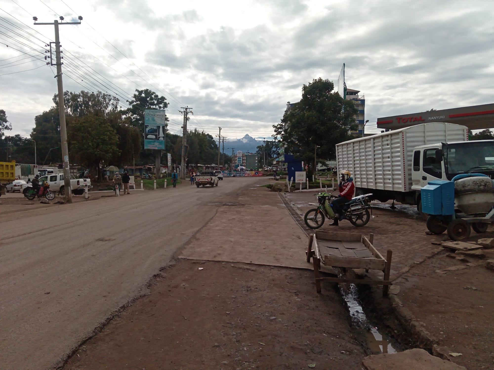
The jagged summit of Mount Kenya rising in the distance above the highland country around the town

The Maasai Mara & the Rift Valley, Kenya

Nanyuki

Mount Kenya seen from Nanyuki, the town at its north-western foot. (Martin Kithinji Mwirigi / Wikimedia Commons · CC BY-SA 4.0)

A highland market town sitting almost exactly on the equator at the north-western foot of Mount Kenya, at the edge of the Laikipia plateau. Founded as a settler farming centre and still a garrison town, it is the base for climbers heading up the mountain and for visitors to the conservancies spread across the plains below it.

Neighbourhoods

  • Town centre
    • First-time visitors
    • Markets
    • Close to transport

    A compact grid of shops, banks, outfitters, bars and hotels around the main street and the market, with matatu and bus stages at its edge. Everything practical for a mountain trip or a safari transfer is within a few blocks.

    Open in Maps
  • The equator strip on the Nairobi road
    • Souvenirs
    • Photo stops

    South of the centre the highway crosses the equator, marked by roadside signs and a cluster of curio stalls and craft workshops that catch passing traffic. Several of the town's larger hotels and lodges lie along this stretch.

    Open in Maps
  • The Timau road and the mountain slopes
    • Quiet and residential
    • Mountain views

    North-east of town the road climbs towards Timau past wheat fields, flower farms and cedar hedges, with cottages and small lodges spread across the lower slopes of Mount Kenya. Cool, green and much quieter than the centre.

    Open in Maps
  • The Laikipia side
    • Wildlife
    • Quiet

    West of the town the ground falls away into the dry Laikipia plateau, where ranches and wildlife conservancies begin within a few kilometres. Accommodation here is scattered, and the roads are unsealed.

    Open in Maps

Things to do

The mountain

  • Mount Kenyaviewpoint

    Africa's second-highest mountain at 5,199 metres, an eroded volcano with glaciers, tarns and moorland; the Sirimon route, the most-used approach from this side, starts on the road east of Nanyuki.

    Open in Maps
  • Mount Kenya National Parkpark

    The park covering the upper mountain, inscribed as a UNESCO World Heritage Site in 1997, with trekking routes to Point Lenana and forest rich in elephant, buffalo and colobus.

    Open in Maps
  • Mount Kenya Wildlife Conservancyattraction

    An animal orphanage and breeding centre on the edge of town that raises orphaned and injured wildlife, including the rare mountain bongo antelope.

    Open in Maps

Conservancies on the plateau

  • Ol Pejeta Conservancypark

    A large private conservancy west of the town holding black and white rhino, the last two northern white rhinos, and a chimpanzee sanctuary, with the mountain as a backdrop.

    Open in Maps
  • Laikipia Plateauviewpoint

    The high, dry country stretching north-west from Nanyuki, a patchwork of ranches, community land and conservancies that together hold much of Kenya's wildlife outside the national parks.

    Open in Maps

Short trips from the town

  • Lewa Wildlife Conservancypark

    A conservancy holding more than a tenth of Kenya's eastern black rhinos and the largest single population of Grevy's zebra in the world; with Ngare Ndare Forest it forms part of the Mount Kenya World Heritage Site.

    Open in Maps
  • Ngare Ndare Foresttrail

    An indigenous forest with natural pools fed by waterfalls and a 450-metre walkway through the tree canopy, crossed by an elephant corridor that links the Mount Kenya forest to Lewa.

    Open in Maps
  • Thomson's Fallsattraction

    A waterfall of about 74 metres on the Ewaso Ng'iro river at the edge of the town of Nyahururu, reached in 1883 by the Scottish explorer Joseph Thomson, who named it for his father.

    Open in Maps

Eat and drink

Long-standing places and food districts in Nanyuki. Hours, ratings and directions come from your maps app, always current.

Nanyuki classics

  • Nyama choma grillsrestaurant

    Goat and beef roasted over charcoal, chopped on a board and eaten with ugali and kachumbari, the standard shared meal in the town's bars.

    Open in Maps
  • Town-centre cafés and bakeriescafe

    Coffee grown on the slopes of Mount Kenya, samosas, mandazi and cooked breakfasts, serving a mixed crowd of farmers, climbers, conservation staff and soldiers.

    Open in Maps

Markets

  • Nanyuki open-air marketmarket

    Highland produce from the surrounding farms — potatoes, cabbages, carrots, peas and maize — alongside secondhand clothes and household goods.

    Open in Maps
  • Equator road craft stallsmarket

    Woodcarving, soapstone and beadwork sold at the roadside where the highway crosses the equator, with workshops attached to some of the stalls.

    Open in Maps

Experience Nanyuki

History

The town began as a colonial outpost. Laikipia had been Maasai grazing land until the treaties of 1904 and 1911 moved Maasai communities south, after which the plateau was opened to European settlement; ranches and wheat farms spread across it, and a small service centre grew where the road and later the branch railway from Nairobi reached the foot of Mount Kenya; British settlers were there from 1907, and the town, which still stands at the end of that branch line, became the trading and shipping point for the farms around it. Its name comes from a Maasai word meaning “resemblance”, for ground reddened like the coat of a roan ox.

Its second character was military. British forces used the district during the Second World War and through the Mau Mau emergency of the 1950s, when the forests of Mount Kenya and the Aberdares sheltered fighters, and after independence the British Army retained a training arrangement with Kenya. The British Army Training Unit Kenya has been based at Nanyuki since, and the Kenya Defence Forces also maintain a presence, which shapes the town's economy and its streets.

From the 1980s the surrounding ranches began turning to wildlife. Ol Pejeta and the other Laikipia conservancies converted cattle country into rhino and elephant range, and Nanyuki became their supply town and airhead as well as the main starting point for the Sirimon route up Mount Kenya. Devolution in 2013 and steady migration have since enlarged it well beyond the old settler grid.

Culture & Customs

Nanyuki is a crossroads town, and its mixture is the point. Kikuyu and Meru farming families, Maasai and Samburu herders from the plateau and the north, conservation staff, soldiers and a long-settled European-descended farming community all use the same few streets, and the market draws sellers from very different kinds of country — highland vegetable growers on one side, pastoralists on the other.

The equator is the town's calling card. Signs beside the highway mark the line, and the curio stalls around them have grown into a small craft industry of woodcarving, soapstone and beadwork, some of it sold through workshops that employ local artisans. The mountain matters more deeply: Mount Kenya is sacred in Kikuyu, Meru and Embu tradition as the dwelling place of Ngai, and prayer has long been made facing its peaks.

The military presence gives Nanyuki a character unlike other Kenyan towns of its size — bars and restaurants that cater to soldiers on leave, and periodic public argument about the conduct and the environmental effect of training exercises. Conservation is the other constant subject, discussed in terms of jobs, fences, grazing rights and compensation for crops and livestock lost to wildlife. Manners are ordinary Kenyan ones: greet before business, respect elders, and ask before taking photographs.

Daily Life

The municipality had an urban population of 72,813 in 2019, a number that has risen quickly as Laikipia County has grown, with far more in the surrounding settlements and farms. The built-up area spreads from the old centre along the Nairobi and Timau roads and into newer estates on the western side.

Work comes from several directions. Farming leads: wheat, barley, potatoes and horticulture on the volcanic soils towards Timau, dairy and livestock on the drier plateau, and cut flowers and vegetables grown for export. Tourism and conservation employ many, in the conservancies, lodges, mountain guiding and transport. The British and Kenyan military bases support shops, rents and services, and the town functions as the commercial hub for a wide area, including the last banks and supermarkets before the roads north to Isiolo.

Days are cool, bright and early, with the mountain visible at dawn and often hidden by cloud by noon. Water supply, unplanned building and pressure on land are live issues, as is the long-running question of who has access to the plateau's grazing: dry seasons have repeatedly brought herders and ranch owners into conflict. Elephants moving through farmland are a familiar problem for smallholders around the forest edge.

Food

Nanyuki eats highland food. Ugali with sukuma wiki, braised collard greens, or a stew of beef, goat or beans is the standard meal; githeri, the boiled mix of maize and beans, is everyday fare inherited from Kikuyu kitchens, as is mukimo, a mash of potato, maize, beans and greens that turns green from the leaves worked into it. Irio, the same idea of mashed peas, potato and maize, is served alongside roast meat.

Nyama choma — goat or beef roasted over charcoal, ordered by weight and cut up on a board with kachumbari — is the social meal, and mutura, a grilled sausage, is sold from evening stalls. Chai boiled with milk and sugar is drunk all day, and coffee grown on the slopes of Mount Kenya is roasted and served in the town's cafés, a rarity in a country that exports most of its beans.

The market is stocked from the farms immediately around the town: potatoes, carrots, peas, cabbages, leeks and maize from the volcanic soils, with milk and meat from the plateau. Trout raised and fished in the cold mountain streams appear on lodge menus, alongside the mixed European and Kenyan cooking that the farming and military communities have supported here for decades.

Planning tools

Budget

The town is cheap; the surrounding country is not. Guesthouse rooms, market food and matatu fares cost little, while conservancy entry fees, guided game drives and the lodges of Laikipia are among the most expensive in Kenya. A Mount Kenya trek is a separate cost again, with park fees charged per day plus guides, porters and hut or camping fees.

Daily Budget Midrange
USD 120–270 (a comfortable hotel or small lodge, restaurant meals, a hired vehicle) — conservancy and mountain days cost more
Daily Budget Shoestring
USD 30–60 (guesthouse, local food, matatus and boda-bodas)

Trekking gear can be hired in town, and conservancy fees are usually charged per person per day, so a single long visit costs less than repeated entries.

Best Time to Visit

January to February and June to September are the driest months and the usual seasons for climbing Mount Kenya, with the clearest mountain views early in the morning at any time of year. The long rains of March to May and the shorter rains around November bring cloud that hides the peaks and turn the plateau tracks to mud.

Suggested Number of Days

A day or two is enough for the town itself and one conservancy nearby. Allow four to six days to add more of Laikipia, and longer again for a mountain trek, which needs several days on its own plus time to acclimatise.

First Visit
1–2 days
With Surroundings
4–6 days

Transportation

Matatus and buses run south to Nairobi and Nyeri and north to Isiolo and Meru, and boda-boda motorcycles and tuk-tuks cover the town. Everything beyond the tarmac — the conservancies, the ranches and the mountain gates — needs a hired 4x4 or a transfer arranged through a lodge or an operator. A revived branch railway also links the town with Nairobi.

Roads on the Laikipia plateau are unsealed, rough and poorly signposted, and wildlife crosses them, so drive slowly and travel in daylight.

Airport & Station Connections

Nanyuki is about 200 km north of Nairobi on the main road past Nyeri, usually three to four hours by road, with frequent buses and matatus. Nanyuki Airport, about 6 km south of the town, handles scheduled light-aircraft flights from Nairobi's Wilson Airport as well as charters. It is the last substantial town before the roads north to Isiolo and the arid frontier.

Walkability

The centre is small, flat and simple to cover on foot, with the market, banks and outfitters in a few streets. Beyond it distances grow quickly: the equator markers are a couple of kilometres south along a busy road with patchy pavements, and the conservancies and mountain gates are far beyond walking range. At about 1,900 metres the air is thin enough that newcomers notice the climb in any uphill walk.

Safety

Nanyuki is a well-used base for tourism and is generally quiet, with the usual risks of petty theft around the market, the bus stages and at night. Wildlife is a real consideration: elephants move between the mountain forest and the plateau, and walking outside fenced areas is done with a guide. Land disputes and occasional armed incursions have affected parts of the wider Laikipia rangelands, mostly well away from the town, and altitude sickness is the main hazard on the mountain.

Avoid the northeastern counties and the immediate Somali border, take care in Nairobi's central and eastern districts and after dark, use hotel or app-based transport, and take malaria precautions outside the highlands. On Mount Kenya ascend slowly and allow time to acclimatise, and take local advice before travelling on the remoter plateau roads. Check current official travel advice before travelling.

Climate

Equatorial but high, so the temperature changes little through the year: warm days, cold nights and rain concentrated in the long rains of March to May and a shorter spell around October and November. The mountain makes its own weather, and afternoons often cloud over.

Summer
January to March is the warmest and clearest stretch, with days around 25°C
Winter
June to August is cooler and greyer, with days near 22°C and nights that can fall to 5°C

Local Customs

The population mixes Kikuyu, Meru and Maasai families with people from across Kenya, and long-established European-descended farming families and a British Army training unit based in the area add an unusual layer for a Kenyan town. Swahili and English are both widely spoken, greetings come before business, and dress in town is modest and practical.

Ask before photographing people, and do not photograph the military installations, police posts or the army training areas around the town; conservancies have their own rules about leaving vehicles.

Common Payment Methods

The currency is the Kenyan shilling. Mobile money is used for almost every small payment, from market stalls to motorcycle fares, and ATMs and banks in the centre are the last dependable ones before the roads north. Lodges and conservancies take cards; markets and transport need cash.