A carved stone church facade and bell tower beside an orange colonial building, with a fountain in the foreground

The Bajío & the Colonial Heartland, Mexico

San Luis Potosí

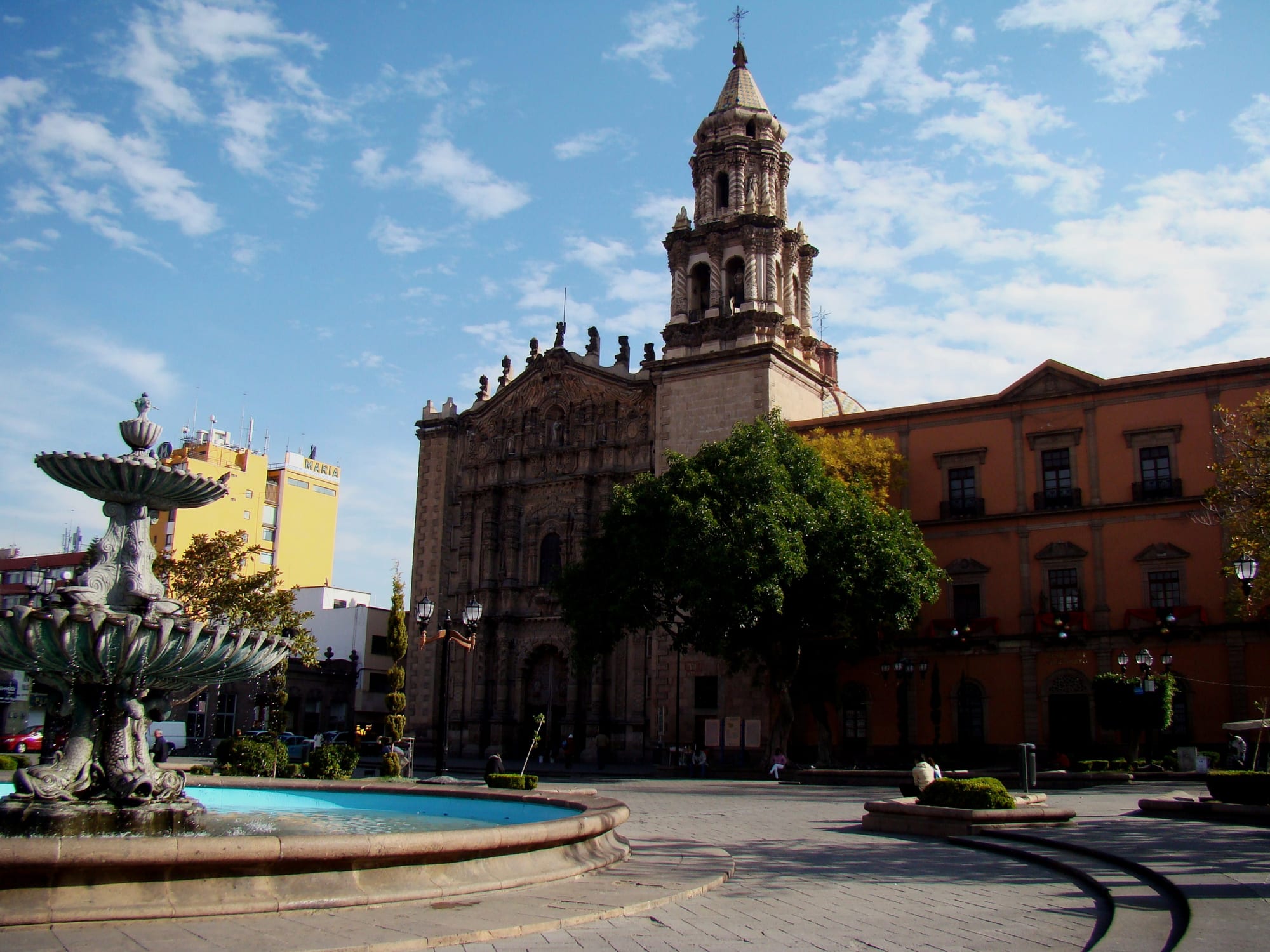
The Templo del Carmen and the fountain on the Plaza del Carmen in the historic centre of San Luis Potosí. (SAHER / Wikimedia Commons · CC BY-SA 3.0)

The capital of San Luis Potosí state, on the high plateau at about 1,860 metres, founded in 1592 to serve the gold and silver mines of nearby Cerro de San Pedro. A baroque centre of plazas, churches and theatres, listed by UNESCO as part of the Camino Real de Tierra Adentro, sits at the heart of one of central Mexico's main industrial cities.

Neighbourhoods

  • Centro Histórico
    • First-time visitors
    • Historic district
    • Best for food

    The colonial core around the Plaza de Armas, the Plaza de los Fundadores and the Plaza del Carmen, with the cathedral, the main churches, theatres and museums close together. Pedestrian streets lead north along Hidalgo to the Mercado Hidalgo, and most hotels and restaurants for visitors are here.

    Open in Maps
  • Calzada de Guadalupe
    • Arts and culture
    • Walks

    A long walking avenue running from the centre to the Basilica and Sanctuary of Our Lady of Guadalupe, with the Centro de las Artes and the Leonora Carrington museum on its way.

    Open in Maps
  • Tangamanga
    • Parks
    • Shopping
    • Quiet and residential

    Modern residential districts and shopping centres around the large Tangamanga I park, home to the Laberinto science and arts museum.

    Open in Maps
  • Soledad de Graciano Sánchez
    • Local life

    The neighbouring city to the east, which forms one metropolitan area with San Luis Potosí.

    Open in Maps

Things to do

Famous landmarks and plazas

  • San Luis Potosí Cathedrallandmark

    The baroque church on the eastern side of the main square, built from 1670 to 1730 and a cathedral since 1854, dedicated to Saint Louis, King of France, the city's patron.

    Open in Maps
  • Plaza de Armaslandmark

    The main square, with the cathedral and the governor's palace of 1770; at Christmas and Easter it hosts evening light shows.

    Open in Maps
  • Templo del Carmenlandmark

    Founded in 1749, with colourful tiled domes and famous altars, considered among Mexico's finest churches and the starting point of the Procession of Silence.

    Open in Maps
  • Plaza de los Fundadoreslandmark

    A square in the centre that, with the Plaza de Armas, hosts evening light shows at Christmas and Easter.

    Open in Maps
  • Teatro de la Pazlandmark

    A theatre in the historic centre, from which the Praetorian Guard of the Procession of Silence sets out.

    Open in Maps
  • Calzada de Guadalupetrail

    A long pedestrian avenue from the centre to the Basilica and Sanctuary of Our Lady of Guadalupe.

    Open in Maps

Museums

  • Museo Nacional de la Máscaramuseum

    A former mansion on the Plaza del Carmen holding about 1,300 masks and dance costumes from Mexico's ritual traditions, the second-largest such collection in the country.

    Open in Maps
  • Museo Leonora Carringtonmuseum

    Opened in 2018, with sculptures, jewellery, engravings and personal objects of the surrealist artist, donated by her son, and exhibitions on surrealism.

    Open in Maps
  • Museo Federico Silvamuseum

    A museum of contemporary sculpture devoted above all to the work of Federico Silva.

    Open in Maps
  • Museo Laberinto de las Ciencias y las Artesmuseum

    A science and arts museum built at a cost of more than 200 million pesos on a 9,000 m² site in Tangamanga I park.

    Open in Maps

Parks

  • Parque Tangamangapark

    Two large public parks, Tangamanga I and II, in the city; Tangamanga I is the second-largest urban park in Mexico after Chapultepec.

    Open in Maps

Short trips from the city

  • Cerro de San Pedroattraction

    The hill village whose gold and silver mines, discovered in 1592, led to the founding of San Luis Potosí.

    Open in Maps

Seasonal events

  • Procession of SilenceGood Friday, March or April

    A night procession from the Templo del Carmen through the historic centre to the sound of drums and bugles, in which no participant or spectator speaks; one of Mexico's most important Holy Week observances.

  • Christmas light showsDecember

    Evening light shows on the Plaza de Armas and the Plaza de los Fundadores, which fill with people during the holidays.

Eat and drink

Long-standing places and food districts in San Luis Potosí. Hours, ratings and directions come from your maps app, always current.

San Luis Potosí classics

  • Enchiladas potosinasrestaurant

    Bright orange enchiladas of corn dough mixed with ancho chilli, folded around cheese and often served with refried beans and guacamole — the city's pride.

    Open in Maps
  • Tacos rojosrestaurant

    One of the street-food favourites the city is known for, sold by stalls and taquerías.

    Open in Maps
  • Tacos sudadosrestaurant

    Steamed tacos made early in the morning and kept warm in large containers, sold for breakfast and lunch.

    Open in Maps

Food districts and markets

  • Mercado Hidalgomarket

    The central market at the end of the pedestrian Hidalgo street north of the Plaza de Armas, selling groceries and food.

    Open in Maps
  • Restaurants of the Centro Históriconeighborhood

    Taquerías, cafés and restaurants serving regional food are spread through the streets around the main plazas.

    Open in Maps

Experience San Luis Potosí

History

Before the Spanish arrived, the dry plains were the land of the Guachichil, a Chichimeca people, and the first settlers of the late 16th century faced constant attacks. In early 1592 gold and silver were found in the hills of Cerro de San Pedro, but the lack of water there made a town impossible, so the settlement was laid out in the valley below. The legal foundation of San Luis Potosí came on 3 November 1592, under a commission from Viceroy Luis de Velasco to Miguel Caldera, considered the city's founder. It was named after Louis IX of France, its patron, and after the fabulously rich mines of Potosí in Bolivia.

Mine wealth and the city's place on the Camino Real de Tierra Adentro, the royal road north from Mexico City, paid for the churches and palaces of the centre. The cathedral was built between 1670 and 1730, the Jesuits founded a college in 1624, the Carmelite church of El Carmen was founded in 1749, and the governor's palace dates from 1770. The Jesuit college later became the Instituto Científico y Literario, which was raised to a university in 1923.

In recent decades the city has become one of the main industrial centres of central Mexico, helped by its position halfway between Mexico City and the US border and between Mexico City, Guadalajara and Monterrey. In 2010 the historic centre was listed by UNESCO as part of the Camino Real de Tierra Adentro, and in 2019 BMW opened a car plant in the industrial zone.

Culture & Customs

Holy Week is the high point of the city's year. On the night of Good Friday the Procession of Silence leaves the Templo del Carmen and winds through the historic centre; drums and bugles sound, but no participant or spectator speaks. It is one of the most important Holy Week observances in Mexico and was declared part of the state's cultural heritage in 2013.

The city has a strong museum culture. The National Mask Museum, in a mansion on the Plaza del Carmen since 1982, holds about 1,300 masks and dance costumes from across Mexico, the second-largest such collection after the Rafael Coronel Museum in Zacatecas. The Leonora Carrington museum, opened in 2018 with works donated by the surrealist's son, has a second venue in Xilitla, in the east of the state, home to Edward James's garden of Las Pozas. Contemporary sculpture has a home at the Federico Silva museum.

The plazas are the centre of public life, especially at Christmas and Easter, when light shows draw crowds to the Plaza de Armas and the Plaza de los Fundadores. The state's other cultures are close at hand: the Wixárika pilgrimage land of Wirikuta near Real de Catorce in the desert to the north, and the Huastec towns of the tropical Huasteca to the east.

Daily Life

The city had 845,941 people at the 2020 census, and the metropolitan area, which takes in the neighbouring city of Soledad de Graciano Sánchez and other municipalities, has more than a million. Residents are known as potosinos.

Manufacturing drives the economy. Foreign companies have invested heavily in the industrial zone, where BMW opened a 300-hectare car plant in 2019, and the airport serves as the main hub of the cargo airline Estafeta and handles freight for industries including auto parts, steel, textiles and furniture. The Autonomous University of San Luis Potosí, descended from the 17th-century Jesuit college, and the state government are also based in the city.

Most people live in the newer districts and housing estates that spread out across the plain, shopping in malls such as Plaza Tangamanga and Plaza San Luis and spending weekends in the Tangamanga parks. The historic centre remains the place for errands, markets and evening walks. A passenger railway linking the city with Querétaro has been announced, with construction expected to begin in 2026.

Food

Potosinos are proudest of their enchiladas potosinas: small, bright orange enchiladas made with corn dough coloured with ancho chilli, folded around cheese and often served with refried beans and guacamole. Tacos rojos are a street-food staple, and tacos sudados, steamed tacos prepared early in the morning and kept warm in big containers, are sold for breakfast and lunch at busy stalls, many of them outside the centre. Tamales are common street food too.

The Mercado Hidalgo, at the end of the pedestrian Hidalgo street north of the Plaza de Armas, is a market for groceries and food, and the streets around the plazas are full of taquerías and cafés.

The state's two other landscapes bring their own food to the capital. From the tropical Huasteca come zacahuil, a very large tamal baked in a wood-fired oven, and bocoles, small corn cakes, while the desert north produces mezcal, which is made in San Luis Potosí as in neighbouring Zacatecas.

Planning tools

Budget

San Luis Potosí is good value. It is an industrial and business city rather than a tourist town, so hotels are aimed at business travellers, and prices in the centre are moderate. Street food and markets are cheap, and most museums charge little.

Daily Budget Midrange
USD 70–150 (hotel in the centre, restaurant meals, museums and taxis)
Daily Budget Shoestring
USD 30–45 (hostel or simple hotel, street food and market meals, city buses)

Tours to the Huasteca and Real de Catorce are long journeys and add substantially to the budget; Holy Week fills hotels for the Procession of Silence.

Best Time to Visit

October to April is dry and clear on the plateau, though January and February are the coolest months. April and May are the warmest, and most rain falls from May to October. Holy Week brings the Procession of Silence, and Christmas the light shows in the plazas.

Suggested Number of Days

One or two days are enough for the historic centre and its museums. The city is also a base for long trips into the desert and the tropical east of the state, which need several more days because of the distances involved.

First Visit
1–2 days
With Surroundings
4–6 days

Transportation

The historic centre is easy to walk. City buses, mostly yellow, cover the rest of the city, and taxis and ride-hailing apps are widely used. The central bus station and the Apolo Platinum terminal are both about 2.5 km from the centre.

Buy taxi tickets at the booth inside the bus station; travel on toll roads and by day for trips into the rest of the state.

Airport & Station Connections

San Luis Potosí International Airport, officially Ponciano Arriaga, lies within the municipality and is a small airport with a limited range of flights; it handled about 835,000 passengers in 2025. The large bus station has frequent services to Mexico City and Monterrey, both about five hours away, and to cities across central Mexico.

Walkability

The centre is flat, compact and pleasant to walk, with several pedestrian streets linking the plazas and the market; the Calzada de Guadalupe extends the walk south. Beyond the centre the city is spread out and built for cars.

Safety

Safety varies enormously by state and even neighbourhood. Parts of San Luis Potosí state are affected by organised-crime violence, especially in rural areas and on some highways, while the historic centre of the capital is busy and well used by residents and visitors.

Avoid rural highways at night, use registered taxis or apps, and keep valuables out of sight. Check current official travel advice before travelling.

Climate

A cold semi-arid highland climate at about 1,860 metres. Temperatures are fairly steady through the year, with a cooler period in January and February and a warmer one in April and May.

Summer
no city figures are given; across the region's plateau, days are typically 24–30°C, with afternoon showers
Winter
no city figures are given; across the region, days are typically 18–24°C and dry, with cold nights

Local Customs

Potosinos are proud of their city's colonial heritage, its Holy Week traditions and their regional food. Greet people with a 'buenos días' or 'buenas tardes' when entering shops and small restaurants. Tipping in restaurants is customary.

During the Procession of Silence spectators are expected to stay silent too. Dress modestly in churches. Drinking alcohol in the street is generally not allowed.

Common Payment Methods

The currency is the Mexican peso. Cards are accepted in hotels, restaurants and shopping centres, and ATMs are common, including in the bus station; cash is needed for markets, street food and tips.