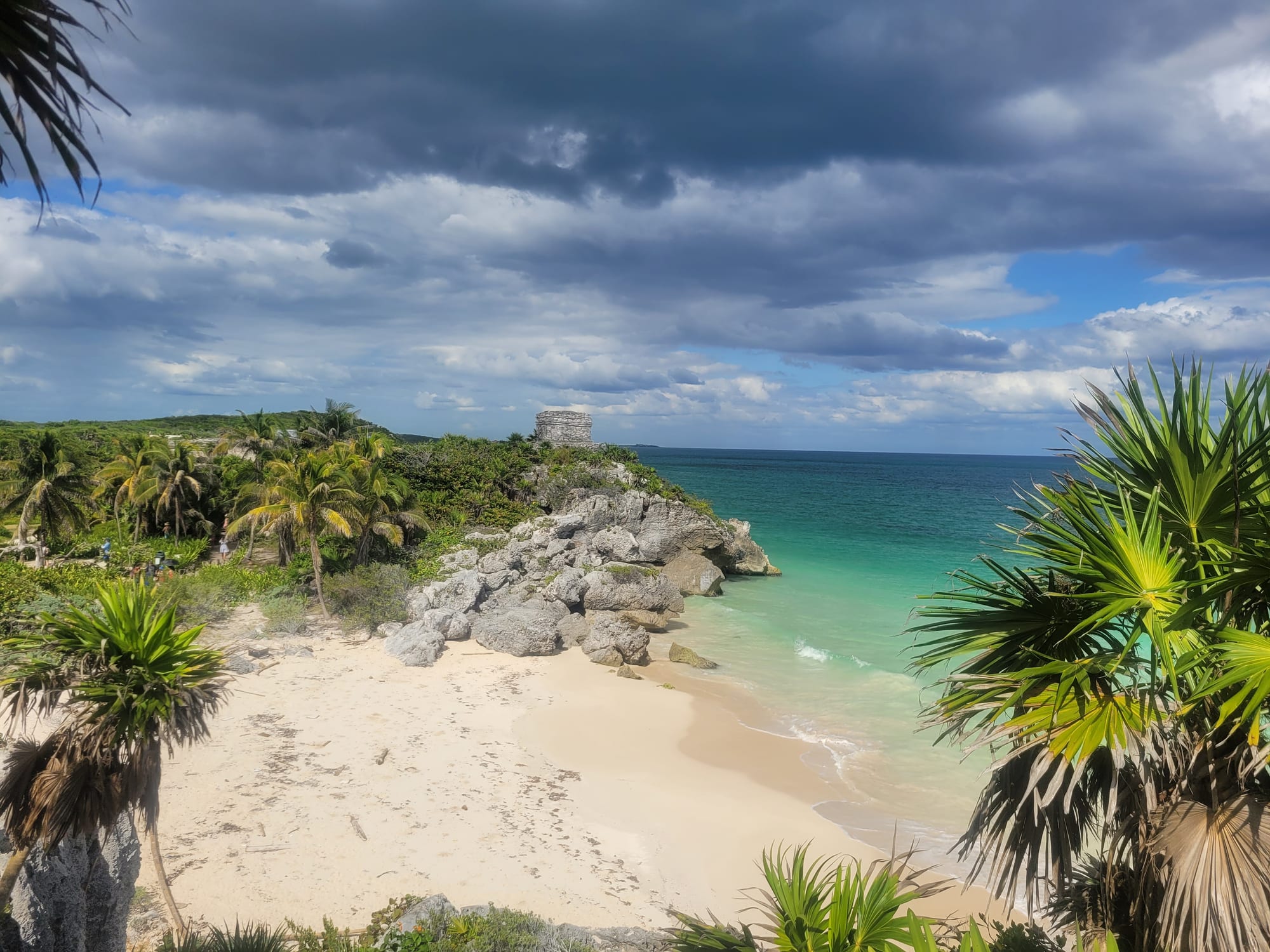
A white sand cove and grey rocks below a small stone Maya temple on a green headland, with turquoise sea and palms

The Yucatán Peninsula, Mexico

Tulum

A cove below the Maya ruins at Tulum, with a small temple on the clifftop above the Caribbean. (Erik Cleves Kristensen / Wikimedia Commons · CC BY 2.0)

A town on the Caribbean coast of Quintana Roo beside the walled Maya port that stands on cliffs above the sea. Founded by Maya rebels during the Caste War and a quiet village until the 1990s, it has grown fast into a resort of boutique beach hotels, jungle restaurants and cenotes, now with its own airport and Tren Maya stations.

Neighbourhoods

  • El Pueblo
    • Budget travellers
    • Best for food
    • Close to public transport

    The town itself, on Highway 307 about 3 km from the beach, where most tourism workers live and where the bus stations, supermarkets, banks, hostels, small hotels and many restaurants are found along and around Avenida Tulum.

    Open in Maps
  • Zona Hotelera
    • Beaches
    • Upmarket stays

    The beach road running south from near the ruins, about 2 km from the town centre, lined with more than 70 boutique hotels, many in thatched Maya-style cabañas, as well as beach clubs, public beaches and restaurants on the jungle side of the road. It continues towards the Sian Ka'an reserve.

    Open in Maps
  • Aldea Zama
    • Quiet and residential
    • Holiday rentals

    A residential area south of the pueblo, one of the developments that have spread into the forest near the town centre.

    Open in Maps
  • La Veleta
    • Quiet and residential
    • Long stays

    A residential district south-west of the pueblo, built up in recent years with homes and holiday rentals in the forest.

    Open in Maps

Things to do

The ruins and the national park

  • Tulum archaeological sitelandmark

    The walled Maya port on 12-metre cliffs above the sea, at its height between the 13th and 15th centuries, with El Castillo, the Temple of the Frescoes and the Temple of the Descending God; one of the most visited sites in Mexico.

    Open in Maps
  • Jaguar National Parkpark

    The federally protected area around the ruins, created for the protection of jaguars; entry requires a paid park bracelet, separate from the ticket for the ruins.

    Open in Maps

Beaches

  • Playa Paraísobeach

    Perhaps the most popular public beach in Tulum, with many beach clubs.

    Open in Maps
  • Playa Santa Febeach

    A less crowded beach with a smaller beach club.

    Open in Maps
  • Playa Pescadoresbeach

    A livelier beach with seafood and activities on the water.

    Open in Maps

Cenotes

  • Gran Cenotepark

    A limestone cave cenote about 7 km north of town on state highway 109, used for swimming and snorkelling.

    Open in Maps
  • Cenote Calaverapark

    A small cenote a short walk from town.

    Open in Maps
  • Dos Ojospark

    Part of a flooded cave system north of Tulum, explored since 1987 and surveyed for more than 80 km, whose cenotes are among the most popular in the region for snorkelling and cavern diving.

    Open in Maps

Short trips from the town

  • Sian Ka'an Biosphere Reservepark

    A reserve of forest, mangrove, lagoons and coral reef south of Tulum, established in 1986 and a UNESCO World Heritage Site since 1987, visited on tours of its lagoons and wildlife.

    Open in Maps
  • Muyillandmark

    One of the earliest and longest-inhabited Maya sites on the east coast of the peninsula, about 25 km south-west of the town on the Sian Ka'an lagoon.

    Open in Maps
  • Cobálandmark

    A great Maya city around two lagoons, the hub of the largest network of stone causeways in the Maya world, once home to perhaps 50,000 people; Tulum served as its port.

    Open in Maps
  • Akumalbeach

    A small resort community on two bays between Tulum and Playa del Carmen, famous for snorkelling with green sea turtles that feed on the sea grass.

    Open in Maps

Eat and drink

Long-standing places and food districts in Tulum. Hours, ratings and directions come from your maps app, always current.

Tulum classics

  • Avenida Tulum taqueríasneighborhood

    The main street of the pueblo has the town's cheapest meals, from al pastor taquerías to seafood places serving fish and marinated marlin tacos and ceviche.

    Open in Maps
  • Restaurants of the Zona Hoteleraneighborhood

    Restaurants on the jungle side of the beach road, some praised in the international press, mixing Mexican cooking with international influences; prices are far higher than in town.

    Open in Maps
  • Pueblo grocery storesmarket

    The supermarkets and shops of the pueblo are where many beach visitors stock up on food and drinks, since beach options are fewer and dearer.

    Open in Maps

Experience Tulum

History

The walled city on the cliffs was one of the last built and inhabited by the Maya. Occupied from around AD 1200 and at its height between the 13th and 15th centuries, it was a port for the inland city of Cobá, where coastal and land routes met; traders brought salt, textiles, obsidian from Guatemala and copper from the Mexican highlands, and a shrine on El Castillo seems to have guided canoes through a gap in the reef. Its name, Tulum, is the Maya word for a wall, and the city may once have been called Zama, "dawn", because it faces the sunrise. Members of Juan de Grijalva's expedition saw it in 1518, and it was abandoned by the end of the 16th century.

John Lloyd Stephens and Frederick Catherwood published the first detailed description of the ruins in 1843. The modern town traces its origins to the Caste War of Yucatán: Maya rebels settled here, and between 1860 and 1870 María Uicab, who became the priestess of the Talking Cross at Tulum, founded the community. For decades afterwards it remained a small fishing village and a stop for chicle gatherers.

Highway 307 reached the area in the 1970s, but as late as the early 1990s Tulum was a quiet village with a few shops and simple beach cabañas. Growth came fast after that. Tulum became the seat of its own municipality in 2008 and was named a Pueblo Mágico in 2015; electricity arrived in the beach hotel zone in 2020, the year Hurricane Gamma hit the town. Tulum International Airport opened in December 2023, and the Tren Maya reached the town in 2024.

Culture & Customs

Tulum has two faces. The pueblo is a working Mexican town, home to most of the people who staff the hotels and restaurants, alongside newcomers from across Mexico and abroad. The beach zone is international, with spas, boutique shops and hotels and beach clubs.

The town's Maya roots run deep. It was founded during the Caste War by María Uicab, priestess of the Talking Cross, and Yucatec Maya is still spoken in the region. The ruins, with the carved figures of the Descending God on their temples, remain at the centre of the town's identity.

The pace of change is itself a local issue. The pressure of tourism on the forest, the cenotes and the coast is a local concern, and some locals also complain that the Jaguar park around the ruins regulates what was once open beach access. Spanish schools and long-stay visitors are now part of the town's fabric.

Daily Life

The municipality of Tulum had 46,721 inhabitants in the 2020 census, and it is among the fastest-growing municipalities in Mexico, drawing people from elsewhere with work in tourism. The town is the largest community in a municipality of 177 localities that takes in the ruins of Cobá and the Sian Ka'an reserve.

Tourism is the economy: hotels, restaurants, tours, dive shops, construction and holiday rentals. Residential developments such as Aldea Zama and La Veleta have spread into the forest around the pueblo, and supermarkets, banks, gyms and tour agencies line the main avenue. Most of the people who work in tourism live in the pueblo. Highway 307 runs through the town, linking it with Cancún to the north and Chetumal to the south.

Current issues follow from that growth: pressure on water, the cenotes and the cave systems beneath the town; high prices; the changes brought by the new airport and the Tren Maya; summer sargassum on the beaches; and hurricanes from June to October.

Food

Tulum eats from two kitchens. In the pueblo, taquerías along Avenida Tulum serve tacos al pastor, spit-roasted pork with pineapple, and seafood in taco and burrito form, including tacos of marinated marlin, along with ceviche, fish and shellfish cured in lime. Yucatecan dishes such as cochinita pibil, pork marinated in achiote and sour orange and slow-cooked in banana leaves, and panuchos, fried tortillas stuffed with black beans, belong to the wider peninsula's cooking and appear on local menus.

On the beach road, restaurants on the jungle side, some praised in the international press, blend Mexican cooking with international influences. Prices there are far higher, and many visitors staying by the sea buy food and drinks in the pueblo.

Fresh fruit waters and cold beer are the drinks of the heat, and the peninsula's honey, from stingless Maya bees kept for centuries, and xtabentún, an anise liqueur made with honey, are regional specialities.

Planning tools

Budget

Tulum is priced for international tourists, and hotels in the beach zone are priced for international visitors, and the cheap cabañas with hammocks of past decades have gone. The pueblo is much cheaper for rooms and food. Entry to the national park, the ruins and each cenote is charged separately, and taxis between town and beach add up.

Daily Budget Midrange
USD 160–350 (boutique hotel or rental, restaurant meals, taxis or car hire, ruins, cenotes and a tour)
Daily Budget Shoestring
USD 50–80 (hostel in the pueblo, taquerías, colectivos and a rented bike, one cenote)

Stay in the pueblo and cycle to the beach to save money; carry cash for park bracelets, cenotes and colectivos.

Best Time to Visit

November to April is dry, with December to March the busy peak. Hurricanes are the main natural concern from June to October, and sargassum seaweed has washed onto this coast in many summers since the 2010s. Arriving at the ruins early, before the tour buses, avoids the worst crowds and heat.

Suggested Number of Days

Two or three days cover the ruins, a beach and a cenote or two. Five to seven allow for the inland Maya cities, the biosphere reserve and the turtle bays to the north; staying overnight makes it easier to beat the crowds from Cancún.

First Visit
2–3 days
With Surroundings
5–7 days

Transportation

The pueblo is compact, but the beach and ruins are a few kilometres away. Bicycles are widely rented and are the usual way between town, beach and nearby cenotes, though the sun is fierce; colectivos run to the beach and along Highway 307 towards Playa del Carmen, and taxis are plentiful but not cheap. A car is useful for cenotes and inland ruins.

When taking a bus to the ruins, book for 'Tulum zona arqueológica' rather than 'Tulum', which goes to the town centre.

Airport & Station Connections

Tulum International Airport, about 20 km south-west of town, opened on 1 December 2023 and handled about 1.2 million passengers in 2025, with domestic and some international flights; it has its own Tren Maya station. Cancún International Airport is about an hour and a half to an hour and three-quarters away by road on Highway 307, with ADO buses from the airport and downtown. The Tren Maya stretch between Playa del Carmen and Felipe Carrillo Puerto, through Tulum, opened in September 2024.

Walkability

The pueblo is flat and easy to walk, with most shops and restaurants on or near Avenida Tulum. The walk to the beach is long and hot, so most people cycle or take a taxi; the ruins are about one and a half kilometres' walk from the highway junction.

Safety

Safety varies enormously by state and even neighbourhood. On the Caribbean coast, Cancún, Playa del Carmen and Tulum have seen shootings linked to rival drug-selling groups, occasionally in bars and near hotels, as well as scams, overcharging taxis and petty theft on the beaches. Natural risks include hurricanes, heat, strong currents on some beaches and cave diving in cenotes without a guide.

Avoid buying drugs, use official taxis and ATMs inside banks or malls, dive in cenotes only with a certified guide, and swim only on beaches without warning flags. Check current official travel advice before travelling.

Climate

A warm, sub-humid climate with a rainy season from May to October. No temperature figures are given for the town itself, so those below are the Yucatán Peninsula region's. The rainy season brings heavy afternoon showers, and hurricanes are possible from June to October.

Summer
hot and humid — around 32°C on the region's coast, with afternoon storms
Winter
warm and dry — 26–30°C by day in the region, occasionally cooler when northern fronts arrive

Local Customs

Tulum mixes a Maya town with a fast-growing international resort, and the pressure of tourism on the forest, cenotes and beaches is a local concern. Swimwear belongs on the beach, and the ruins are an archaeological site with rules to follow.

Respect closed areas at the ruins (the stairway to the beach below the main temple is restricted), follow the rules at each cenote, keep off coral, and ask before photographing people.

Common Payment Methods

The currency is the Mexican peso; paying in US dollars usually means a poor rate. Cards work in most hotels and many restaurants, but cash is needed for colectivos, cenotes and small eateries. Banks and ATMs are in the pueblo.