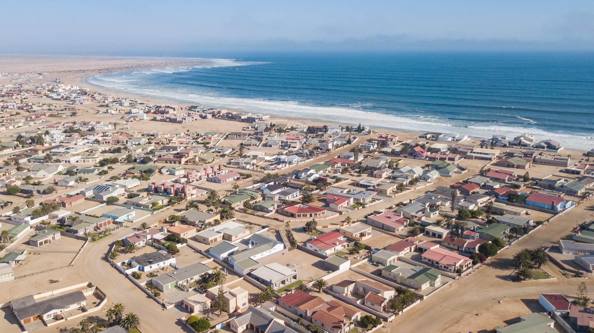
Aerial view of a low coastal town of pale bungalows on sandy streets beside a long surf beach and blue ocean

Swakopmund, Damaraland & the Skeleton Coast, Namibia

Henties Bay

Henties Bay spread between the desert and the Atlantic surf on Namibia's Erongo coast. (Arne Müseler / Wikimedia Commons · CC BY-SA 3.0 de)

A small holiday and fishing town on Namibia's Atlantic coast, a little south of the mouth of the dry Omaruru River, between the desert and the surf. Founded as an angling camp in the late 1920s, it grew into a low, spread-out town of holiday houses that fills with Namibian families and shore anglers in the summer holidays and stands half empty and fog-bound the rest of the year.

Neighbourhoods

  • The seafront and the river mouth
    • First-time visitors
    • Beaches
    • Fishing

    The strip above the beach at the north end of the town, below the point where the dry Omaruru riverbed meets the sea, with the lookout points, the slipway down to the sand and most of the guesthouses. Anglers drive along the shore from here, and the fog often sits over the water until late morning.

    Open in Maps
  • The town centre
    • Supplies and fuel
    • Close to the beach

    A small grid a few streets back from the sea holding the supermarket, fuel station, bank, tackle shops and takeaways. It is the last full-service town before the Skeleton Coast Park, so vehicles stop here to fill up and stock up.

    Open in Maps
  • The holiday-house suburbs
    • Quiet and residential
    • Long stays

    Low bungalows and walled plots spread over the gravel slope above the sea, many of them second homes belonging to families from Windhoek and the interior. They are lively over December and January and quiet for much of the year.

    Open in Maps
  • The gravel plains behind the town
    • Quiet and residential
    • Local life

    Inland of the main road the land turns to bare gravel and salt pans, with the township area, workshops, the fisheries campus and a small airstrip. There is no shade and the desert begins immediately beyond the last houses.

    Open in Maps

Things to do

The shore and the desert

  • Omaruru Riverattraction

    An ephemeral river rising in the Etjo Mountains and reaching the sea just north of Henties Bay, flowing above ground only after heavy inland rain and otherwise a band of sand and trees at the edge of the town.

    Open in Maps
  • Dorob National Parkpark

    The coastal park that runs along this stretch of shore, protecting lichen fields, gravel plains, dunes and breeding sites of the Damara tern, with vehicle tracks marked to keep traffic off the crusts.

    Open in Maps
  • Skeleton Coastattraction

    The fog-bound shore of shipwrecks, whale and seal bones and desert running north from here, its name taken from the bones that once littered the beaches and the wrecks driven ashore by rocks and fog.

    Open in Maps
  • The Zeila wreckattraction

    A stripped fishing trawler that ran aground just off the shore about 14 kilometres south of town in August 2008, when its tow line broke on the way to the scrapyard, and now a much-photographed wreck reached from the coast road.

    Open in Maps

Short trips along the salt road

  • Cape Crossattraction

    A headland holding one of the largest Cape fur seal colonies in the world, and replicas of the stone padrão the Portuguese navigator Diogo Cão planted here in 1486.

    Open in Maps
  • Messum Craterattraction

    A ring of hills about 20 km across on the gravel plains, the eroded remains of a volcanic complex that collapsed some 130 million years ago, reached on desert tracks.

    Open in Maps
  • Swakopmundattraction

    The German-built seaside town at the mouth of the Swakop River, with colonial architecture, a jetty, museums and the dune belt behind it.

    Open in Maps
  • Spitzkoppelandmark

    A group of bare granite peaks rising more than 1,700 metres above sea level, with San rock paintings on the rock and a campsite among the boulders.

    Open in Maps

Eat and drink

Long-standing places and food districts in Henties Bay. Hours, ratings and directions come from your maps app, always current.

Fish and the town

  • The seafront eating placesneighborhood

    A short line of restaurants, bars and takeaways near the shore serves the coast's line fish — kabeljou, steenbras and galjoen — as well as calamari, fish and chips, and steaks for those who have had enough of the sea.

    Open in Maps
  • The supermarket and bakery in the centremarket

    The main shops sell braai meat, bread, biltong and the ice and bait anglers need; a bakery counter turns out Brötchen, pies and doughnuts in the German-Namibian style.

    Open in Maps
  • Braai at the beach housesneighborhood

    Much of the eating here happens at home — the day's catch grilled over coals or fried in a pan, roosterkoek baked on the grid, and potjie stews on cold, foggy evenings.

    Open in Maps

Experience Henties Bay

History

The coast here was empty of permanent settlement for most of its history: the Namib gave no fresh water, and the Topnaar and other Khoekhoe-speaking groups used the lower riverbeds inland rather than the shore. The dry mouth of the Omaruru River, where water can be reached under the sand, was the one usable point on this stretch.

The town is named after Major Hendrik "Henty" van der Merwe, who reached the coast in 1929 while hunting in the interior, found fresh water in a sand valley south of the Omaruru mouth and returned the following Christmas to build a hut in the riverbed. Others followed, plots in the riverbed were let from 1951, and the settlement grew slowly as an angling camp of shacks and caravans reached over rough desert tracks. It was proclaimed a town later, as tarred and salt roads reached the coast and made the drive from Windhoek and Swakopmund straightforward.

Growth came with holidays and with mining. Namibian and South African families built second homes along the shore, while uranium and salt workings in the desert behind the coast, and the fishing industry further south, drew permanent residents. The town is run by its own municipal council, has gained a University of Namibia campus for marine and maritime studies, and its population has more than doubled in a generation as people moved in from inland. It remains a town of two rhythms: crowded in the December holidays, quiet under the fog for the rest of the year.

Culture & Customs

Henties Bay's culture is built around shore angling. The town calls itself an anglers' town, and the beaches north and south of it are divided into named fishing spots reached by 4x4, with tackle shops, bait suppliers and guides in the centre. Competitions and club outings fill the holiday weeks, and catch-and-release practice and size limits are argued over as seriously as the fishing itself. Rods on roof racks and a cool box in the back are the town's uniform.

The population is mixed. Afrikaans-speaking Namibian families, retired people from the interior and a German-Namibian element give the town a southern African seaside character — braais in the late afternoon, rugby on a screen in the bar, caravans on the plots — while Oshiwambo- and Damara-speaking residents who came for work make up a growing share of the permanent community. English is the official language, but Afrikaans is what is usually spoken in the street.

Life bends to the sea and the sky. The fog decides whether the morning is spent outdoors; the tide decides when anglers go down to the beach. There is a strong awareness of the fragility of the desert around the town: the lichen fields on the gravel plains take decades to recover from a single set of tyre tracks, and the Damara tern nests on open gravel, so keeping to marked tracks is treated as basic good manners rather than a rule for tourists.

Daily Life

About 7,000 people live here, counted at the 2023 census, in a town whose numbers swell several times over in December and January. The permanent economy rests on tourism and the holiday-house trade, on fishing and the services that go with it, and on wages from the uranium mines and salt works in the desert behind the coast, which many residents reach by daily commute.

The town has a supermarket, fuel, a bank, a clinic, schools and a campus of the University of Namibia teaching marine and maritime subjects, and Swakopmund, an hour south, supplies anything more specialised. Water is piped from boreholes in the Omaruru riverbed, and its supply is a standing concern in a place with effectively no rainfall.

Days start grey. The fog usually clears by late morning, the wind rises in the afternoon, and the streets are quiet by evening except over the holidays, when the beachfront fills with families, braai smoke and vehicles heading out to the fishing spots. Formal work is limited and seasonal, informal housing has grown on the inland edge of the town, and many households depend on a mix of casual work, pensions and money earned elsewhere. Retired people form a large part of the permanent population, which gives the town a settled, unhurried feel.

Food

Fish is the point. The Benguela current fills these waters with cold-water species, and what comes off the beach — kabeljou, also called kob, silver steenbras and the prized galjoen — is what appears on the table, usually grilled over coals or fried in butter with lemon. Snoek is smoked or braaied, and crumbed hake and chips are the standard takeaway. Rock lobster and oysters arrive from the bays further south.

Away from the sea, the food is Namibian braai cooking: beef and lamb chops, boerewors coiled on the grid, oryx or kudu steaks, and potjiekos simmered slowly in a three-legged pot on a cold, damp evening. Roosterkoek, bread rolls baked straight on the grid and split open with butter, and pap with a tomato-and-onion sauce round out the meal. Biltong and dried sausage go in the car for a day on the beach.

The German-Namibian inheritance shows in the bakeries — Brötchen, rye loaves, apple cake — and in the country's lagers, brewed to the old purity law and drunk cold whatever the weather. Vetkoek filled with mince, meat pies and strong sweet coffee from a takeaway counter are the informal food of the fishing trip, and rooibos tea is the usual drink at home.

Planning tools

Budget

Henties Bay is one of the cheaper places to stay on the Namibian coast, with self-catering flats and holiday houses rather than hotels, and a campsite. Prices rise sharply over the December and January school holidays, when Namibian families book months ahead. Fuel, a hire car and fishing charters or guided trips north are the main extra costs.

Daily Budget Midrange
USD 150–400 (a guesthouse or holiday house, restaurant dinners, a hire car, a guided fishing or Cape Cross trip)
Daily Budget Shoestring
USD 45–80 (camping or a self-catering flat shared, cooking the day's catch, a shared hire car, fuel)

Self-catering is the norm here; buying meat and fish in town and cooking at the house costs a fraction of eating out every night.

Best Time to Visit

The coast is mild all year and never hot. December and January bring Namibian holidaymakers, full accommodation and the liveliest version of the town; the rest of the year is quiet, grey and often foggy. Anglers come through the cooler months for the shore fishing, and winter days are the clearest for driving the coast road.

Suggested Number of Days

A night or two covers the town and the shore. Three or four days suit anyone fishing, driving further up the coast or combining the visit with the desert inland. Fog, tides and the distance between stops on the salt road decide the pace more than the number of sights.

First Visit
1–2 days
With Surroundings
3–4 days

Transportation

Everything here runs on vehicles. The salt road C34 runs along the coast through the town, and the C35 heads inland to Uis and Damaraland; a saloon car handles both in normal conditions, while driving on the beach or into the dunes needs a 4x4 and local knowledge. There is no scheduled public transport for visitors, and lifts or shared minibuses serve residents travelling to Swakopmund.

Salt roads become slippery when fog wets them, so speeds should come down in the mornings; salt spray and beach sand are hard on vehicles, which are usually rinsed off afterwards.

Airport & Station Connections

The town lies about 70 km north of Swakopmund on the coastal salt road, roughly an hour's drive, and about four hours from Windhoek by way of the paved B2 and the coast. The nearest airport with scheduled flights is at Walvis Bay, about 100 km south. There is a local airstrip for charter flights, and almost all visitors arrive by car.

Walkability

The town is flat and quiet, and the beachfront makes a long, easy walk, but the streets are spread out over several kilometres of gravel slope with few shops and little shade between them. Most residents and visitors drive even short distances; the centre itself can be covered on foot in a few minutes.

Safety

Crime is low and the town feels safe, with occasional theft from parked cars and holiday houses. The dangers here are natural: a cold Atlantic with strong currents and sudden swells that catch anglers on the rocks, thick fog on the salt road, soft sand that strands vehicles on the beach, and long stretches north of town with no fuel, water or phone signal.

Carry extra water, fuel and two spare tyres, tell lodges the route, keep well back from elephants and do not swim on the open coast. Check current official travel advice before travelling.

Climate

Cool, dry and foggy, shaped by the cold Benguela current offshore. Rain is almost unknown; moisture arrives as sea fog that rolls in overnight and burns off by late morning. Hot, dry east winds occasionally push desert air to the coast and send temperatures up for a day or two. In the southern hemisphere summer runs from December to February.

Summer
mild, about 17–25°C, with morning fog and cool sea breezes
Winter
cool and grey, about 12–20°C, with occasional warm berg-wind days

Local Customs

This is a relaxed, Afrikaans- and German-speaking holiday town where English is widely understood and dress is informal. Fishing etiquette matters: anglers space themselves along the beach, driving is kept to marked tracks to protect the lichen fields and the nests of the Damara tern, and catch limits and permits apply to shore fishing.

Ask before photographing people or their homes, keep vehicles off the crusted gravel and dunes, and tip around 10 per cent in restaurants and a little to fuel attendants.

Common Payment Methods

The Namibian dollar is the currency, pegged one-to-one to the South African rand, and rand is accepted. Cards work at the supermarket, fuel station and most restaurants, and there are ATMs in the centre, but cash is useful for stalls, small charters and tips, and there is none to be had north of the town.