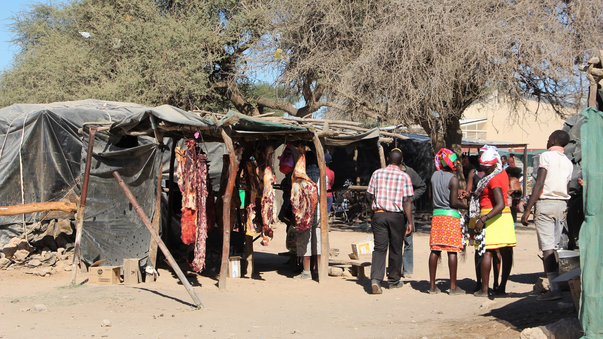
Wooden and tarpaulin market stalls under thorn trees on bare sandy ground, with shoppers in bright wrapped skirts standing nearby

Swakopmund, Damaraland & the Skeleton Coast, Namibia

Opuwo

Stalls at the open market in Opuwo, the trading centre of Kaokoland. (Leomudde / Wikimedia Commons · CC BY-SA 4.0)

The capital of Namibia's Kunene Region and the only real town in Kaokoland, the dry, mountainous north-west. A dusty administrative and supply centre of shops, offices and a market, it is where herding families from the surrounding hills come to trade, and the last place to buy fuel and supplies before the tracks towards the Kunene river.

Neighbourhoods

  • The main street
    • First-time visitors
    • Shops and fuel
    • Banks

    A single tarred road through town lined with supermarkets, filling stations, a bank, government offices and takeaways. Everything practical happens along it, and it is where herders, officials and travellers all cross paths.

    Open in Maps
  • The market and taxi area
    • Local life
    • Street food
    • Markets

    The open market and the stands around it, where meat, maize meal, vegetables, tobacco, ochre and second-hand clothes are sold and bakkies load up for the villages. The busiest and most sociable part of town.

    Open in Maps
  • The hill edges and lodges
    • Quiet and residential
    • Views over the valley

    Guesthouses, campsites and a lodge on the rising ground around the town look out over mopane-covered hills and the broad valley. Quiet, a short drive from the centre, and the usual base for travellers.

    Open in Maps
  • The outlying settlements
    • Local life
    • Countryside

    Beyond the built-up strip, homesteads of pole, mud and thatch stand among goat and cattle kraals, and families move between them and the town. Most of the district's population lives this way rather than in the town itself.

    Open in Maps

Things to do

In the town

  • Opuwo open marketmarket

    The town's market, where meat is butchered under the trees and maize meal, vegetables, ochre, tobacco and clothing are traded by families from across Kaokoland.

    Open in Maps
  • Craft stalls in the townmarket

    Himba and Herero jewellery, leatherwork, carvings and dolls made in the surrounding villages and sold in the town, much of it by the families who make it.

    Open in Maps
  • Opuwo airstriptransit hub

    A small airfield on the edge of town used by charter and light aircraft serving lodges and government services in the north-west.

    Open in Maps
  • Himba homestead visitsattraction

    Visits to homesteads near the town, arranged through community guides on agreed terms, where families explain herding life, hairstyles, dress and the sacred fire.

    Open in Maps

Roads out of town

  • Ruacanaattraction

    A small town beside the Kunene river and the Ruacana hydroelectric power station, near falls that are 120 metres high and run strongly only when the river is in flood.

    Open in Maps
  • The Kaokoland hillsviewpoint

    The arid, mountainous region around the town, a landscape of mopane hills, dry riverbeds and scattered homesteads that begins at the edge of the built-up area.

    Open in Maps

Eat and drink

Long-standing places and food districts in Opuwo. Hours, ratings and directions come from your maps app, always current.

Market food and town kitchens

  • Opuwo open marketmarket

    Freshly butchered goat and beef grilled over coals, maize meal, beans, dried fruit and seasonal wild foods sold from stalls and open ground.

    Open in Maps
  • Takeaways on the main streetneighborhood

    Chicken and chips, pap and stew, meat pies and cold drinks from the supermarkets and small takeaways along the tarred road.

    Open in Maps
  • Lodge restaurants above the townneighborhood

    The guesthouses and lodges on the surrounding hills serve set dinners of grilled meat, stews and vegetables, usually the only sit-down meals in town.

    Open in Maps

Experience Opuwo

History

The dry mountains of Kaokoland were settled by Herero-speaking herders, among them the Himba, who moved with cattle between seasonal grazing, and by Ovatjimba and Zemba communities. Colonial administrations reached the area late and lightly: the Germans scarcely entered it, and under South African rule the region was treated as a closed area, with movement in and out controlled and outsiders kept away, which left both its herding economy and its isolation largely intact.

Opuwo itself grew from the colonial administrative office for Kaokoland, which moved here from Swartbooisdrift on the Kunene at the end of the 1930s and gave the town its offices, clinic and school. Kaokoland was established as a self-governing homeland in 1980, with Opuwo as its administrative centre, though no homeland government was ever formed and it was abolished in 1989. During the liberation war the north-west was caught up in the fighting along the Angolan border, and the same period saw the first roads pushed through to the Kunene.

Severe droughts in the early 1980s, combined with the war, killed a large share of the region's cattle and drove families towards the town for relief food and work, which is why Opuwo grew quickly and unevenly. After independence in 1990 it became the capital of the new Kunene Region. Community conservancies established from the 1990s brought wildlife recovery and some income from tourism and hunting, and the town has since filled with government offices, shops and the traffic of travellers heading for the Kunene river.

Culture & Customs

Opuwo is where several ways of living meet in one street. Himba families arrive from the hills, the women wearing leather skirts and coated in otjize, a paste of red ochre and butterfat that protects the skin and marks identity; Herero women come in the long Victorian-style dresses and horn-shaped headdresses adopted from missionaries; and officials, teachers and shopkeepers in Windhoek clothes work in the offices in between. The mixture is the town's defining sight and the reason it draws visitors.

Cattle are the centre of Himba and Herero life, measures of wealth, subjects of song and the material of ceremony, and the sacred fire at a homestead links the living family with its ancestors. Hairstyles and jewellery signal age, marriage and status precisely, which is why photographs taken without asking are read as theft rather than admiration.

Tourism here is unusually delicate. Some villages welcome visitors on community-run terms, with agreed fees and guides who interpret and set the rules; casual visits by tour vehicles are widely resented, and posed photography for money has strained relationships in places near the main road. Plans for a hydroelectric dam on the Kunene river, which would flood ancestral land and graves, have been opposed by Himba leaders for years and remain a live political issue.

Daily Life

About 12,000 people live in Opuwo, which makes it a small town by most measures and a metropolis by Kaokoland's. It is the seat of the regional government and holds the district hospital, secondary schools, the police and the offices that administer an enormous and thinly populated area. Housing runs from government blocks and brick bungalows to large informal areas of pole-and-mud and corrugated iron on the outskirts.

Most income comes from government salaries, small businesses and trade, from conservancy and lodge work, and from herding: goats and cattle are still the basis of household wealth in the villages, sold in town when cash is needed. Drought is the great threat, and the herding economy has been repeatedly weakened by years of poor rain, which pushes more families towards town. Unemployment is high, and alcohol is a visible social problem.

The day begins early, before the heat, with pick-ups bringing people in to shop, collect pensions and visit the hospital, and empties again in the afternoon. Water supply, schooling for children from far-flung homesteads and the long distances to clinics shape everyday life more than anything a visitor sees. Mobile phone coverage, solar panels and second-hand vehicles have changed the region quickly in one generation.

Food

Everyday food in Kaokoland is simple and built on maize and milk. The staple is a stiff maize porridge, oshifima or pap, eaten with the hands and dipped in a relish of meat, beans or wild greens. Soured milk, omaere, from cattle and goats, is a daily food in herding households and is drunk thick or eaten with porridge; butterfat from the same milk is mixed with ochre for otjize rather than used in cooking.

Meat is goat and beef, usually slaughtered for an occasion and grilled over coals or boiled, with nothing wasted — offal, head and marrow bones all have their place. The market butchers under the trees supply the town, and the smell of grilling meat runs along the street through the afternoon. Wild foods matter in season: berries, the fruit of the mopane and marula, and roots and greens gathered on the hills.

In town the food is Namibian and practical. Supermarkets sell maize meal, bread, tinned goods and cold drinks; takeaways do chicken and chips, fat cakes (vetkoek) and meat pies; and lodges serve grilled meat, stews and vegetables with Namibian lager or South African wine. Tea with plenty of sugar is the common drink, and traditional sorghum and honey beers are brewed in villages for gatherings.

Planning tools

Budget

Opuwo is cheap for food and basic rooms but expensive to reach, and fuel is the dominant cost of any trip through Kaokoland. Guesthouses and campsites in town are modest, while the conservancy lodges further out charge high rates. Guided visits to homesteads and conservancy fees add to the daily total.

Daily Budget Midrange
USD 150–400 (lodge or guesthouse, dinners, a hired 4x4 with fuel and a guided community visit)
Daily Budget Shoestring
USD 45–80 (campsite or basic guesthouse, market and supermarket food, a shared 4x4, community fees)

Fill the tank and buy supplies here: fuel stations and shops are very far apart once the tar road ends.

Best Time to Visit

May to September is the practical season, when the heat is bearable, the tracks are dry and the dust has settled a little. October to December is very hot, often above 35°C. Summer rains between about January and April turn the hills green but can wash out riverbed crossings and cut off villages for days.

Suggested Number of Days

The town itself needs only a night, usually as a stop for fuel and supplies. Three to five days makes sense for anyone exploring the wider north-west, where distances are long, tracks are slow and plans depend on the state of the roads.

First Visit
1 day
With Surroundings
3–5 days

Transportation

The town is small enough to walk across, and shared taxis and pick-ups carry people between the centre and the surrounding settlements. Beyond that a high-clearance 4x4 is essential: roads north and west are gravel and then sand and rock, river crossings are common, and there is little traffic to help if something breaks. Minibuses run to Outjo and Windhoek.

Travel in the north-west with two spare tyres, extra fuel and water, and tell someone the route, since mobile coverage disappears within a short distance of town.

Airport & Station Connections

Most visitors drive. The gravel and partly tarred road from Kamanjab takes around three hours, and Opuwo is roughly a long day's drive from Windhoek or from the coast at Swakopmund. Minibuses connect the town with Outjo and Windhoek. A small airstrip handles charter flights for lodges, and the road north-east leads to Ruacana and on towards the Kunene river.

Walkability

The town is compact, flat and easily crossed on foot in twenty minutes, with the shops, market and offices strung along one road. Surfaces are sandy and dusty, there is little shade and the midday heat is severe for much of the year. Lodges on the surrounding hills are a drive rather than a walk from the centre.

Safety

Opuwo is generally calm, with petty theft, pickpocketing around the market and alcohol-related trouble at night the main risks. Far more serious is the remoteness: breakdowns, flash floods in dry riverbeds, very high temperatures and no mobile signal outside town. Livestock and wild animals share the roads, and driving after dark is hazardous.

Carry extra water, fuel and two spare tyres, tell lodges the route, keep well back from elephants and do not swim on the open coast. Check current official travel advice before travelling.

Climate

Hot and semi-arid, with a single short rainy season from about January to April and a long dry season. Being in the southern hemisphere, summer falls in December to February and winter in June to August. Nights cool sharply in winter, and the town sits high enough for mornings to feel cold before the sun rises over the hills.

Summer
very hot, about 32–38°C by day, with occasional heavy thunderstorms and humid air
Winter
warm days of about 25–30°C with cold nights that can fall to 5–10°C

Local Customs

Otjiherero is the main language, with English used in offices and shops. Himba, Herero and Zemba families come into town in their own dress, and photographing people without asking is intrusive and resented; visits to homesteads should be arranged through community guides on terms agreed in advance, with a gift of food such as maize meal, sugar or tobacco more useful than cash handed to children. Sacred fires and the paths between them and the main hut are not to be crossed.

Ask permission before every photograph and accept refusal; greet elders first, dress modestly, and buy crafts in the town rather than bargaining hard at homesteads.

Common Payment Methods

The currency is the Namibian dollar, pegged one to one with the South African rand, which is also accepted. There are banks and ATMs in town and cards work in the supermarkets, filling stations and lodges, but they are the last such facilities on most routes north and west. Cash in small notes is needed for the market, crafts, community fees and tips.