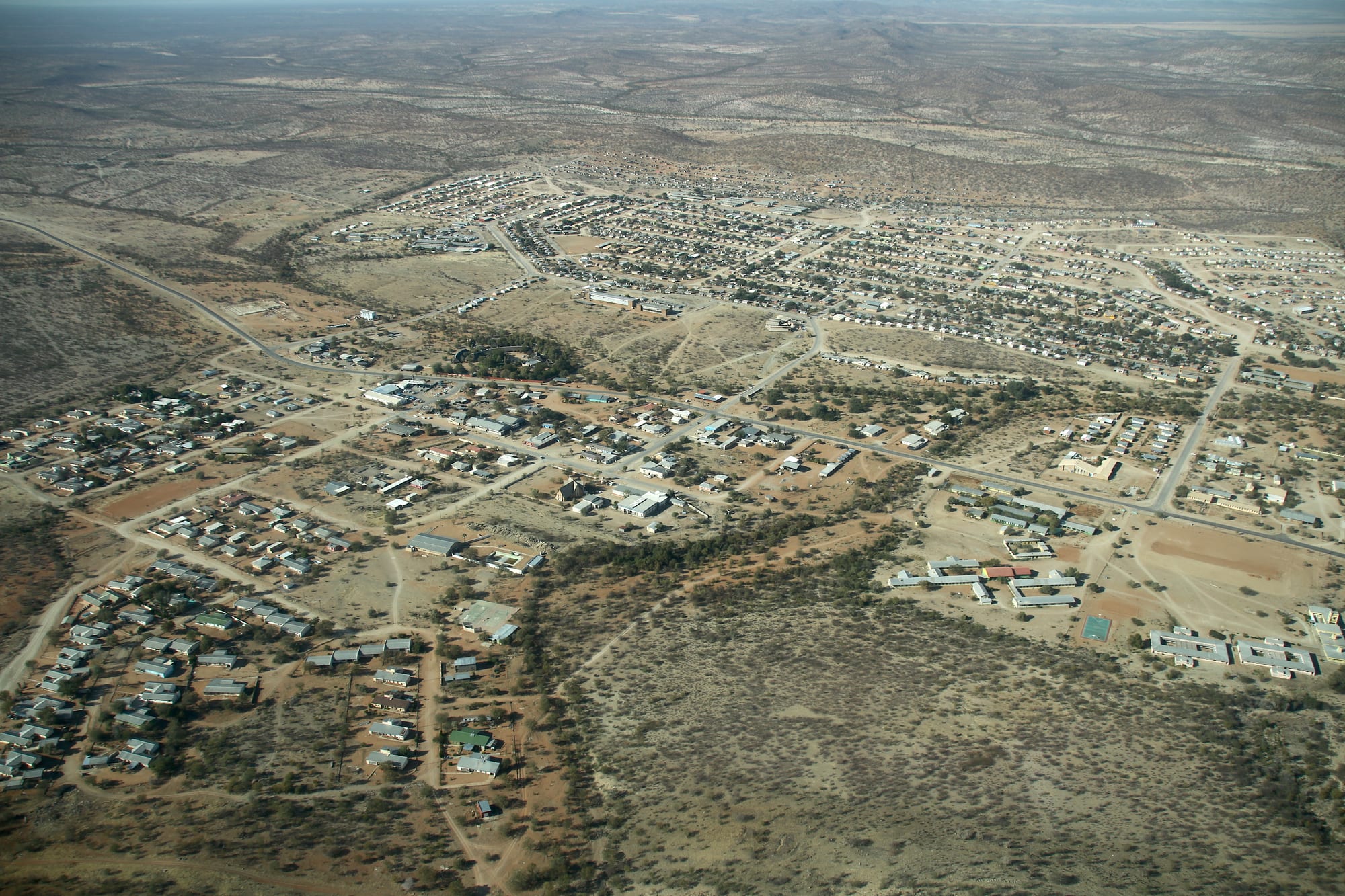
Aerial view of a low desert town of small houses and wide sandy streets spreading across dry scrubland towards distant hills

Swakopmund, Damaraland & the Skeleton Coast, Namibia

Khorixas

Khorixas from the air, spread across the dry Damaraland plain in Namibia's Kunene Region. (Hp.Baumeler / Wikimedia Commons · CC BY-SA 4.0)

A small service town on the C39 gravel road in the Kunene Region of north-western Namibia, built up as the administrative centre of the Damaraland homeland under South African rule. It is the usual refuelling and supply stop for travellers heading to the rock engravings of Twyfelfontein, the petrified forest and the basalt Organ Pipes, in a dry country of flat-topped hills and dry riverbeds.

Neighbourhoods

  • The centre along the C39
    • First-time visitors
    • Supplies and fuel

    The main gravel road through town carries almost everything a traveller needs — the fuel station, a supermarket, small shops, the bank, offices and takeaways. It is busy in the morning and quiet by mid-afternoon, and it is the last reliable place to fill up before the tracks west towards Twyfelfontein.

    Open in Maps
  • The residential blocks
    • Local life
    • Quiet and residential

    Rows of small government-built houses and later self-built homes spread north and east of the centre, with churches, schools, a clinic and open sandy ground between them. Goats graze the edges of the streets and the pace is unhurried.

    Open in Maps
  • The lodges on the edge of town
    • Overnight stops
    • Quiet and residential

    A handful of lodges and campsites sit on the outskirts and along the roads out, most with a pool, a bar and a view of the plain. They are used mainly as a night's stop between the coast, Twyfelfontein and Etosha rather than as a destination.

    Open in Maps

Things to do

Short trips west along the C39

  • Petrified forestlandmark

    A deposit of fossilised tree trunks swept here by an ancient flood and turned to stone, two of them about 45 metres long and lying exposed among welwitschia plants; a national monument since 1950.

    Open in Maps
  • Twyfelfonteinlandmark

    A sandstone valley holding thousands of rock engravings of animals, tracks and symbols, inscribed as Namibia's first UNESCO World Heritage Site in 2007 and visited with local guides.

    Open in Maps
  • Organ Pipesattraction

    A rock face of tall, angular basalt columns resembling organ pipes, formed when lava pushed into slate about 150 million years ago and was later laid bare by erosion.

    Open in Maps
  • Burnt Mountainviewpoint

    A hill of solidified lava at the foot of a volcanic ridge, looking scorched against the pale Karoo slate around it, its reds, browns and purples strongest at dusk; a national monument since 1956.

    Open in Maps

Short trips east and south

  • Vingerkliplandmark

    A slender pillar of sandstone and conglomerate about 35 metres high, left standing above the Ugab valley as the surrounding rock eroded away and visible for a long way across open country.

    Open in Maps
  • Brandberg Mountainlandmark

    A granite massif rising above the plain, its ravines sheltering thousands of rock paintings, among them the figure known as the White Lady.

    Open in Maps

Eat and drink

Long-standing places and food districts in Khorixas. Hours, ratings and directions come from your maps app, always current.

Eating in Khorixas

  • The C39 through townneighborhood

    Takeaways, a bakery counter and a supermarket along the main road cover most meals in town — grilled and fried meat, pap, bread, pies and cold drinks.

    Open in Maps
  • Open-air meat grillsmarket

    Kapana, thin strips of beef grilled over coals and eaten standing with salt, chilli powder and a bread roll, is sold at informal stalls near the shops.

    Open in Maps
  • Lodge kitchens on the edge of townrestaurant

    The places to stay around the town serve set dinners built on game and beef — oryx or kudu steak, stews cooked in a potjie, and a braai on the terrace.

    Open in Maps

Experience Khorixas

History

Khorixas takes its name from Khoekhoegowab, the language of the Damara and Nama, and the springs and grazing of the area were used by Damara herders long before any town existed. The surrounding country, with its rock engravings and painted shelters, carries far older traces of hunter-gatherers who lived along these dry river valleys.

The settlement as it stands today is largely a creation of South African rule. Under the Odendaal plan of the 1960s the administration divided South West Africa into ethnic homelands, and in the 1970s Khorixas was built up as the administrative capital of Damaraland, the homeland designated for the Damara. Offices, housing, schools and a hospital were put up on the plain, and people were moved into the town and its constituency from a wider area, giving it a size and a street grid out of proportion to the thin economy around it.

With independence in 1990 the homelands were abolished and their boundaries redrawn; Khorixas lost its capital status and became a constituency seat in the new Kunene Region, and later a town council. Since then its fortunes have rested on two things: its place as the supply point for a large area of communal farming, and the growth of tourism at Twyfelfontein, whose engravings were inscribed as Namibia's first UNESCO World Heritage Site in 2007 and which brought guiding, craft and lodge work within reach of the town.

Culture & Customs

Khorixas is one of the main Damara towns of Namibia, and Damara identity is strong here. Khoekhoegowab, shared with the Nama and marked by its click consonants, is heard everywhere, and Afrikaans and English serve as the languages of trade and administration. The Damara traditional authority and its annual gatherings, church congregations and choirs, and family networks spread across the communal farms give the town its social shape.

Churches are central to public life. Lutheran and Catholic congregations founded in the mission era stand alongside newer Pentecostal churches, and Sunday morning belongs to them: choirs in uniform, long services, and family meals afterwards. Women's long Victorian-style dresses and headscarves, adopted in the mission period and now a marker of Damara and Nama identity, appear at weddings, funerals and festival days.

Craft and guiding have become part of local culture through tourism. Curio stalls along the roads sell carved wood, ostrich-eggshell beads and stone, and guides trained in the area lead visitors around the engravings and explain them in Khoekhoegowab as much as in English. There is a quiet pride in the rock art as Damara heritage rather than as scenery, and in the conservancies, where residents manage wildlife on communal land and take a share of tourism income in return for living beside elephants that raid gardens and water points.

Daily Life

About 9,000 people live in Khorixas, and the town serves a far larger scattered population of communal farmers. Most households depend on some mixture of goats and cattle, a government salary or pension, casual work and money sent home. Unemployment is high, and many young people leave for Swakopmund, Walvis Bay or Windhoek.

The working day starts early, before the heat. The fuel station, supermarket, bank and government offices along the main road do most of their business in the morning; by early afternoon the streets are quiet and shaded stoeps fill up. Water, delivered to standpipes and yards, is a constant preoccupation, and repeated droughts have forced herders to sell stock or drive it long distances to grazing.

Tourism is the other economy. Lodges, campsites, guiding at Twyfelfontein and the conservancies to the west, and craft selling provide the cash jobs that farming cannot, although the work is seasonal and concentrated in the dry months. Electricity, a regional hospital, schools and mobile coverage reach the town itself, while settlements out along the gravel roads have far less, and more specialised medical care is hours away by road.

Food

Eating in Khorixas is plain, meat-centred and shaped by what keeps in a hot, dry place. Maize meal cooked into a stiff porridge — pap, or mieliepap — is the daily staple, eaten with a stew of goat, beef or offal and a tomato-and-onion sauce. Goat is the everyday meat of the communal farms, and a slaughter for a wedding or funeral feeds a large gathering.

Grilled meat is the social food. Kapana, thin slices of beef cooked fast over coals and dipped in salt and chilli powder, is bought by the handful at street stalls, and a braai over a wood fire, with meat and roosterkoek, bread rolls baked on the grid, is the standard way of marking a weekend. Biltong and dried sausage travel well and are sold in the shops. Game from the farms and conservancies — oryx, springbok and kudu — turns up as steaks and stews on lodge menus rather than in home kitchens.

Vetkoek, fried dough eaten with mince or jam, and fat cakes from a street pan are the usual snacks, and bread and tinned goods from the supermarket fill in the rest. Traditional Damara cooking still uses wild foods from the veld — bush berries, tubers and the seasonal fruit of desert plants — and soured milk. Tea with plenty of sugar, rooibos, and Namibian lager or home-brewed drinks are what people drink.

Planning tools

Budget

Khorixas is inexpensive by Namibian standards and is mainly a fuel and supply stop. Campsites and simple guesthouses cost little; the lodges on the edge of town and out towards Twyfelfontein are the main expense, along with fuel, the Twyfelfontein guide fee and any guided tracking of elephants or rhino from the conservancy lodges.

Daily Budget Midrange
USD 150–400 (a lodge on the edge of town or in Damaraland, dinner and breakfast, a hire car, a guided rock-art or elephant trip)
Daily Budget Shoestring
USD 45–80 (camping or a basic guesthouse, self-catering from the supermarket, a shared hire car, fuel and entry fees)

Fuel and groceries are cheaper and more reliable here than anywhere west or north of the town, so it is worth stocking up before heading on.

Best Time to Visit

May to October, the dry, cooler months, when daytime heat is manageable for walking at the rock-art sites and desert elephants stay close to the dry riverbeds. From November to March the plains are very hot, though a good rainy season briefly turns the gravel green and fills the riverbeds, which can cut tracks for a day or two.

Suggested Number of Days

Most travellers stop for a single night. Two or three nights suit anyone wanting the rock-art sites at an unhurried pace, a conservancy activity or a longer loop east towards the Ugab terrace. Distances on gravel, not the number of sights, decide how long it takes.

First Visit
1 day
With Surroundings
2–3 days

Transportation

The town is small enough to cross on foot, and everything beyond it needs a vehicle. Almost all visitors arrive in their own hire car; there is no scheduled public transport to the sights, though shared minibuses and lifts link the town with Outjo, Kamanjab and Uis. Lodges arrange guided drives to Twyfelfontein and into the conservancies.

Gravel roads here are corrugated and stony, punctures are common, and a slower speed with tyre pressures let down a little is the usual way to avoid a rollover.

Airport & Station Connections

Khorixas sits on the C39 gravel road, roughly two hours west of Outjo and about four to five hours north of Swakopmund by way of Uis. Windhoek is a long day's drive away. There is an airstrip used by charter and safari flights, but no scheduled service, so nearly everyone arrives by road.

Walkability

The centre is easily walked: the shops, fuel station, bank and offices stand within a few hundred metres of each other along the main road. Streets are sandy and largely unlit, there is little shade, and the town thins out quickly into open veld, so walking between the residential blocks and the lodges takes longer than it looks.

Safety

Khorixas is a calm town with little crime beyond occasional opportunistic theft. The real risks are the surroundings: long gravel roads with no phone signal, heat and dehydration at the rock-art sites, and wildlife — desert-adapted elephants move through the Huab and Aba-Huab riverbeds and near settlements west of the town.

Carry extra water, fuel and two spare tyres, tell lodges the route, keep well back from elephants and do not swim on the open coast. Check current official travel advice before travelling.

Climate

Hot semi-desert, with big differences between day and night and rain that is scarce and unreliable. Any rain falls in summer thunderstorms between about December and March; the rest of the year is dry, clear and dusty. In the southern hemisphere summer runs from December to February.

Summer
very hot, with days often 33–38°C and warm nights; occasional heavy afternoon storms
Winter
warm sunny days of about 23–28°C and cold nights that can approach freezing

Local Customs

This is Damara country, and Khoekhoegowab, with its click consonants, is the common language alongside Afrikaans and English. Greetings matter: a handshake and a few words before business are normal, and people are addressed politely by title. Dress is modest and practical. Rock-art sites are visited with a local guide, and the engravings are never touched.

Ask before photographing people, their homes or their livestock, agree any fee first, and tip guides at the rock-art sites; a small rounding-up is normal in restaurants.

Common Payment Methods

The currency is the Namibian dollar, pegged one-to-one to the South African rand, and rand is accepted. There is a bank with an ATM in town and cards are taken at the fuel station, the supermarket and the lodges, but stalls, guides and community fees are cash, and there is nothing to draw on once the town is behind.