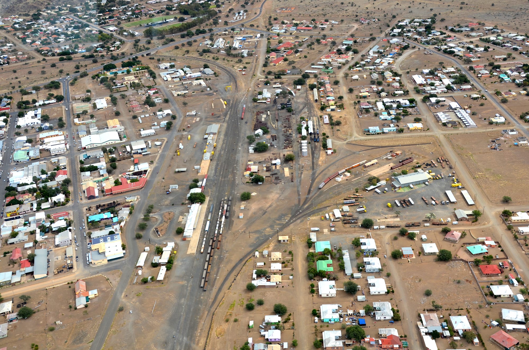
Aerial view of a low desert town, its railway yard and sidings running through the centre between flat-roofed buildings

Sossusvlei, Fish River Canyon & the South, Namibia

Keetmanshoop

Keetmanshoop from the air, with the railway yard and sidings that made the town a junction of the southern lines. (Olga Ernst & Hp.Baumeler / Wikimedia Commons · CC BY-SA 4.0)

The main town of southern Namibia and the capital of the ǂKaras Region, grown from a Rhenish mission station of 1866 into a road and railway junction on the B1. Sheep farming, the railway and passing traffic sustain it, and the quiver tree stands and dolerite boulder fields on the farms outside are what most travellers come to see.

Neighbourhoods

  • The town centre
    • First-time visitors
    • Services and shops
    • Historic buildings

    A grid of wide streets around Fifth Avenue and Mittel Street, holding the municipal offices, the banks, supermarkets, filling stations and most of the town's guesthouses. The old stone mission church that now houses the museum stands here, a short walk from the main shops.

    Open in Maps
  • The station quarter
    • Railway history
    • Close to the main road

    The eastern side of the centre, laid out around the station, the goods sheds and the long sidings that still carry freight. Workshops, hardware yards and transport depots line the streets, and freight still moves through the yard.

    Open in Maps
  • Krönlein and Tseiblaagte
    • Local life
    • Quiet and residential

    The older township areas west and south of the centre, where most of Keetmanshoop's residents live. Small houses, churches, bars and corner shops fill the streets, and Khoekhoegowab and Afrikaans are heard more than English.

    Open in Maps
  • The farm road out of town
    • Quiver trees
    • Stargazing
    • Guest farms

    The gravel road running north-east towards the quiver tree country, lined with sheep and game farms that take guests. The dolerite outcrops begin a few kilometres out, and the night skies are very dark once the town's lights drop away.

    Open in Maps

Things to do

In the town

  • Keetmanshoop Museummuseum

    The town museum, housed in the Rhenish mission church of 1895, with displays on the Nama, the missionaries and early farming life.

    Open in Maps
  • Keetmanshoop Airporttransit hub

    The airfield on the edge of town, long used by light aircraft, charters and flying-school traffic crossing southern Namibia.

    Open in Maps

Desert landmarks nearby

  • Quiver Tree Forestattraction

    A stand of about 250 tree aloes on a farm about 14 km north-east of the town, declared a national monument in 1995, whose branches the San once hollowed out for arrow quivers.

    Open in Maps
  • Giant's Playgroundattraction

    A field of dolerite blocks, formed about 180 million years ago and weathered into towers and balanced piles that look stacked by giants, on the same farm road as the quiver trees.

    Open in Maps

Short trips from the town

  • Mesosaurus Fossil Siteattraction

    Slabs of shale on a farm east of the town holding fossils of Mesosaurus, a small aquatic reptile of the Early Permian whose remains in both southern Africa and South America became evidence for continental drift.

    Open in Maps
  • Naute Damattraction

    A reservoir on the Löwen river, the third largest dam in Namibia, with an irrigated date farm below the wall and birdlife on the water.

    Open in Maps

Seasonal events

  • Independence Day21 March

    Marked in Keetmanshoop with a public ceremony, sport and music, as in every Namibian town.

  • Heroes' Day26 August

    A national holiday remembering the liberation struggle, observed in the south alongside commemorations of the Nama leaders of the colonial wars.

Eat and drink

Long-standing places and food districts in Keetmanshoop. Hours, ratings and directions come from your maps app, always current.

Keetmanshoop classics

  • Karas lamb and gamerestaurant

    Lamb raised on the dry veld around the town is the local meat of choice, served as chops from the grill or slow-cooked in a potjie, with gemsbok and kudu steaks beside it on most menus.

    Open in Maps
  • Biltong and droëwors countersmarket

    Butcheries in the centre cure their own biltong and droëwors, the salted air-dried beef and thin sausage that Namibians buy by the bag for long drives.

    Open in Maps
  • Vetkoek and roosterkoek stallsmarket

    Fried dough filled with mince, and bread rolls baked on the coals, sold from small stalls and takeaways near the main streets and the station.

    Open in Maps

Where people eat

  • Fifth Avenue and the centreneighborhood

    The town's cafés, bakeries, takeaways and grill restaurants are concentrated in a few blocks of the centre, with bakeries selling the German breads and cakes common across southern Namibia.

    Open in Maps
  • Naute dates and farm producemarket

    The irrigated farm below the Naute dam grows dates for export, and its fruit turns up in shops and farm stalls around the town.

    Open in Maps

Experience Keetmanshoop

History

Keetmanshoop began as a mission. The Nama of the area, the Kharoǃoan clan, split from the Red Nation and settled here in 1850, watering their stock at a spring in the valley Afrikaans-speakers call Swartmodder, 'black mud'. The first Rhenish missionary, Johann Georg Schröder, arrived on 14 April 1866, now taken as the town's founding date, and the mission was named for Johann Keetman, a German trader and director of the Rhenish Missionary Society who paid for it and never visited the place. The stone mission church of 1895 still stands in the centre and holds the town museum.

German colonial administration followed the declaration of the protectorate over South West Africa, and Keetmanshoop became a garrison and district seat for the southern interior during the wars of 1904 to 1908 against the Nama and Herero, a period recognised as genocide. The railway made the modern town: the line from Lüderitz reached Keetmanshoop in 1908, built to serve the interior and then, after diamonds were found near Kolmanskop the same year, to carry the traffic of the coastal diamond fields. Later connections northward to Windhoek and east towards South Africa turned the town into the junction of the southern network.

Under South African rule the district became karakul sheep country, and Keetmanshoop prospered as the market and rail-head for the pelt trade, which declined as demand for fur fell. Since independence in 1990 the town has been the capital of the ǂKaras Region, living on administration, the farms around it, road transport along the B1 and a steady trickle of travellers heading for the quiver trees and the canyon.

Culture & Customs

Keetmanshoop is a Nama town in language and habit. Khoekhoegowab, with its click consonants, is spoken in the townships and on the farms, Afrikaans is the common tongue across communities, and English belongs to the office and the classroom. Nama culture is strong in the south: the Victorian-style long dresses and headscarves worn by older women and at celebrations, the guitar and violin music of the riel, and the memory of leaders such as Hendrik Witbooi of nearby Gibeon, honoured as a national hero.

Church life shapes the calendar. The Rhenish mission left a Lutheran inheritance that remains visible in the old stone church and in the choirs that sing at weddings, funerals and holidays, and other denominations have their own congregations across the town. Funerals in particular draw large gatherings, with family travelling in from farms and from Windhoek.

Farming is the other axis of local identity. The agricultural show, livestock sales and talk of rain and grazing set the rhythm of the year for both the commercial farmers of the district, many of them Afrikaans and German-speaking families settled for generations, and the stock owners of the communal areas. Sport means football and rugby on weekend afternoons, and the long summer evenings are spent outside, around a braai, once the heat has gone out of the day.

Daily Life

About 27,900 people live in Keetmanshoop, counted in 2023, which makes it the largest town in the far south and the administrative centre of the ǂKaras Region. The centre holds the regional council, the courts, the hospital, the schools and the shops; most residents live in Krönlein, Tseiblaagte and the newer areas on the edges, where small houses, churches and shebeens fill the streets and where unemployment is high.

The economy rests on government offices, the schools and hospital, the shops and workshops serving a very large farming district, and the traffic of the B1 — trucks, coaches and tourist vehicles all stop here for fuel and food. Sheep and goat farming remains the basic industry of the countryside, with game farming and guest farms added in recent decades, and the irrigated farm below the Naute dam grows dates for export. The railway still moves freight, though passenger travel has dwindled.

Days begin early to beat the heat and slow in the afternoon, when shutters come down and the streets empty for a while. Water is the constant concern: recurring drought thins the flocks, forces farmers to buy feed and pushes families off the land towards the towns. Young people leave for Windhoek and the coast for work, and the town's population grows slowly rather than quickly.

Food

Keetmanshoop eats what the district raises. Lamb from the dry veld, where sheep graze on aromatic shrubs, is the meat that farmers and townspeople agree on, grilled as chops over coals at a braai or cooked slowly with vegetables in a three-legged potjie pot. Game from the surrounding farms — gemsbok, springbok and kudu — appears as steaks and stews, and both meat and game are dried into biltong, salted and air-cured in the very dry air, and into thin droëwors sausage, sold by the bag in butcheries and eaten on the road.

Everyday cooking is shared with Afrikaans and Nama kitchens across the south: mealie pap, a stiff maize porridge, with a tomato and onion sauce; vetkoek, fried dough split and filled with curried mince; roosterkoek, bread rolls baked directly on the grill and torn open with butter and jam; and potjiekos left to stew for hours. Offal dishes such as afval, and skaapkop, are old farm cooking still served at gatherings.

The German inheritance shows in the bakeries, where Brötchen, rye loaves and heavy cakes are sold beside the tins of the supermarket. Rooibos tea is drunk all day, local lagers such as Windhoek and Tafel are the standard beers, and South African wines fill the shelves, along with dates from the irrigated farm at the Naute dam down the road.

Planning tools

Budget

Keetmanshoop is one of the cheaper stops in southern Namibia: town guesthouses and campsites are modest, meals are inexpensive, and the farms outside charge small entry fees for the quiver trees and the boulder fields. Fuel and the hire car are the real costs, since almost everyone arrives by road and the distances either side of the town are long.

Daily Budget Midrange
USD 130–260 (a town guesthouse or guest farm, restaurant meals, a hire car and fuel, the quiver tree and Naute excursions)
Daily Budget Shoestring
USD 40–75 (a campsite or backpacker room, self-catering from the supermarkets, a shared hire car, farm entry fees)

Fill the tank here — Keetmanshoop is the last large town before the canyon, Aus and the Orange river, and fuel stops beyond it are far apart.

Best Time to Visit

April to September, when days are warm rather than fierce and the nights are cold and clear. Photographers favour the quiver trees at sunrise and sunset in these months, and the dark winter skies are excellent for stars. Midsummer, from December to February, is very hot, with occasional thunderstorms that briefly green the veld.

Suggested Number of Days

Most travellers stop for a night, which is enough for the town and the country immediately around it. Two or three days suit anyone adding the farms, dams and longer drives further out, and photographers often stay longer for the light on the aloes.

First Visit
1 day
With Surroundings
2–3 days

Transportation

The town is small enough to cross on foot, and everything beyond it needs a vehicle. There is no local bus network; minibus taxis run between the centre and the townships, long-distance minibuses stop on their way along the B1, and the farms and dams outside are reached only by private car or an arranged transfer. The gravel farm roads are normally fine for a saloon car driven slowly.

Keep speeds well down on gravel, where loose surfaces and sudden ridges cause most of the serious accidents in the south, and avoid driving after dark because of livestock and game on the road.

Airport & Station Connections

Keetmanshoop sits on the paved B1 about 500 kilometres south of Windhoek, a drive of five to six hours, and about 300 kilometres north of the Orange river border with South Africa. The B4 runs west from here through Aus to Lüderitz. Long-distance minibuses and coaches on the Windhoek–Cape Town route call at the town, and the railway through it carries freight; the airport handles light aircraft rather than scheduled services.

Walkability

The centre is flat, quiet and easily walked: the museum, the shops, the banks and most guesthouses lie within a few blocks of each other. The townships spread further out and the sights are all on farms several kilometres away, so walking covers the town but not the reason most people come. Summer heat and the lack of shade make midday walking uncomfortable.

Safety

Keetmanshoop is a calm town with little crime that affects travellers, though petty theft happens as in any road town and unlit streets on the edges are best avoided at night. The greater risks are the heat, long distances between services, and the gravel roads to the farms and dams, where rollovers are the commonest serious accident.

Namibia is one of the safer countries in Africa for visitors. Carry water on any farm road drive, tell someone the route, keep valuables out of sight in a parked car, and drive slowly on gravel. Check current official travel advice before travelling.

Climate

Hot semi-desert with very little rain, most of it falling in summer thunderstorms between January and April. The air is dry, the sun strong and the daily swing between afternoon and dawn large in every season. Being in the southern hemisphere, summer runs from December to February and winter from June to August.

Summer
very hot, with afternoons commonly 33–38°C and warm nights, broken by occasional thunderstorms
Winter
sunny days around 20–24°C with cold nights that often fall to freezing on the surrounding farms

Local Customs

The south is Nama country, and Khoekhoegowab and Afrikaans are the everyday languages, with English used in offices and schools. Greetings are unhurried and a handshake is normal. Dress is practical and modest; churches are central to town life and Sunday mornings are quiet. Farms outside town are private property, and the quiver tree stands and boulder fields are entered through their gates and offices.

Tipping of around ten per cent is usual in restaurants, ask before photographing people, and ask at the farmhouse before leaving the marked tracks on any farm.

Common Payment Methods

The currency is the Namibian dollar, pegged one-to-one to the South African rand, and rand notes are accepted everywhere in town. Cards work at supermarkets, filling stations and most guesthouses, and there are ATMs in the centre, but the farms, stalls and small shops often want cash, so it is worth drawing enough here before heading into the surrounding district.