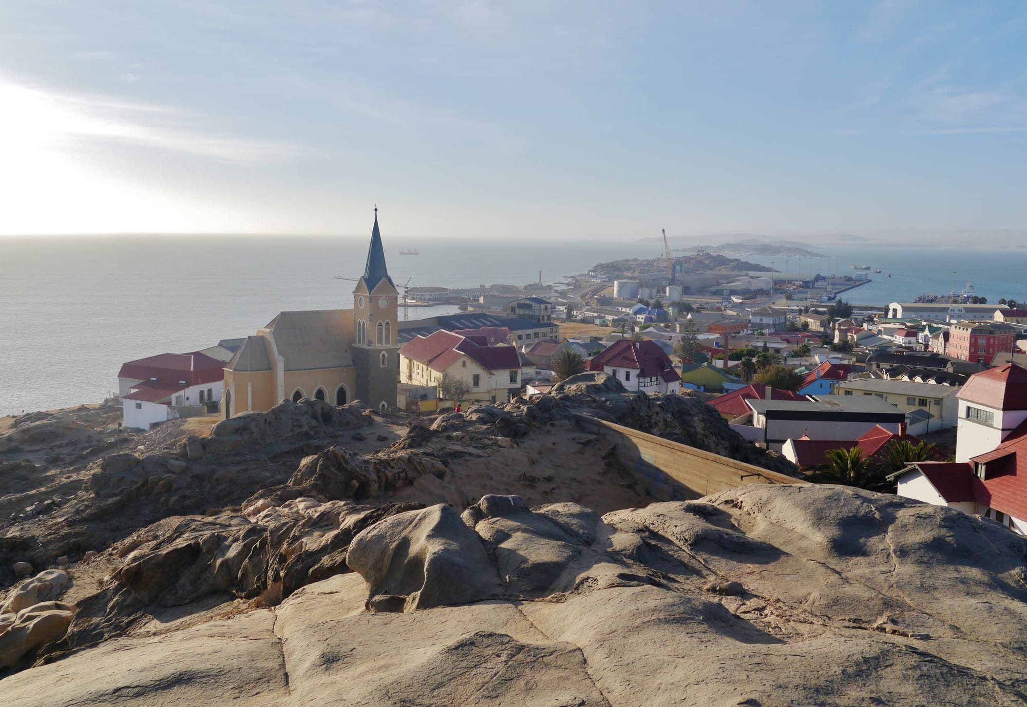
A church with a tall spire on bare rock above a small town of coloured roofs, with the harbour and open sea beyond

Sossusvlei, Fish River Canyon & the South, Namibia

Lüderitz

Lüderitz seen from the Diamantberg, with the Felsenkirche above the town and the harbour and bay behind it. (Zairon / Wikimedia Commons · CC BY-SA 4.0)

A small harbour town on a rocky, wind-scoured bay in southern Namibia, where the Namib Desert meets the cold Atlantic. Founded as the first German settlement in the territory in 1883 and enriched by the diamond rush that began in 1908, it keeps streets of German colonial and Art Nouveau houses, a church on a rock above the bay, and an economy built on fishing, mining and tourism.

Neighbourhoods

  • The old town and the waterfront
    • First-time visitors
    • Historic district
    • Architecture

    The compact grid below the church holds the colonial and Art Nouveau houses, the museum, shops and most guesthouses, running down to the harbour and a small waterfront development of restaurants and jetties. Almost everything a visitor comes for is within a few streets.

    Open in Maps
  • The rocky hills above
    • Architecture
    • Views

    The Felsenkirche and the grandest of the old merchants' villas, among them the Goerke House, stand on the bare granite ridges behind the town, reached up steep streets. The views run over the roofs to the bay, the peninsula and the desert.

    Open in Maps
  • The harbour and the industrial edge
    • Local life
    • Seafood

    Fish-processing plants, boatyards, the oyster and rock-lobster businesses and the port itself occupy the northern shore. It is a working area rather than a pretty one, but it explains most of the town's jobs.

    Open in Maps
  • The residential suburbs
    • Local life
    • Quiet and residential

    Nautilus and the older township area of Benguela spread inland on the sand and rock, mixing bungalows, blocks of flats and informal housing. This is where most residents live, and where the town has grown fastest in recent years.

    Open in Maps

Things to do

The old town

  • Felsenkirchelandmark

    The Lutheran 'church on the rock', consecrated in 1912, standing on a granite outcrop above the town with stained glass and a view over the bay.

    Open in Maps
  • Goerke Hauslandmark

    A villa built in 1909-11 for a diamond-company official on the slope below the church, a showpiece of colonial Art Nouveau with a stair window, painted friezes and period furnishings.

    Open in Maps
  • Lüderitz Museummuseum

    A small town museum covering the Nama and San of the region, the German colonial period, the diamond rush and the natural history of the coast.

    Open in Maps
  • Shark Islandlandmark

    A rocky peninsula, once an island, joined to the town by a causeway; it was the site of a concentration camp between 1905 and 1907 in which large numbers of Nama and Herero prisoners died, and it carries memorials to them.

    Open in Maps

The bay and the peninsula

  • Diaz Pointviewpoint

    A headland a short drive west of the town on the Lüderitz peninsula, with a replica of the stone cross that the Portuguese navigator Bartolomeu Dias planted in 1487, a lighthouse of 1915, and seals and seabirds on the rocks below.

    Open in Maps
  • Halifax Islandattraction

    A small island off the peninsula holding a colony of African penguins, viewed from boat trips out of the harbour along with seals, flamingos and, at times, dolphins.

    Open in Maps
  • Agate Beachbeach

    A long sandy beach a few kilometres north of the town, exposed to the wind and the cold Benguela current, known for the small agates that can be found on it.

    Open in Maps

Short trips from the town

  • Kolmanskopattraction

    A diamond-rush town about 10 km inland, abandoned in the 1950s, whose German houses, hospital, shop and ballroom are slowly filling with sand; it is visited on permitted tours.

    Open in Maps
  • Sperrgebiet National Parkpark

    The old diamond Sperrgebiet, or forbidden zone, closed to the public for a century and now a national park, entered only with a permit or on authorised tours.

    Open in Maps

Seasonal events

  • Lüderitz Speed Challengesouthern spring, about September to November

    An international speed-sailing event held since 2007 on a purpose-cut canal on the lagoon west of the town, where windsurfers and kitesurfers use the strong, steady southerly wind to chase world speed records.

  • Lüderitz Crayfish Festivalonce a year

    The town's annual crayfish festival, built around the rock lobster known locally as crayfish, for which, along with oysters, Lüderitz is a centre.

Eat and drink

Long-standing places and food districts in Lüderitz. Hours, ratings and directions come from your maps app, always current.

Seafood by the harbour

  • The waterfront restaurantsneighborhood

    The small harbour-side development is where most visitors eat, with rock lobster in season, oysters from the bay, kingklip, kabeljou and other line fish, calamari and mussels.

    Open in Maps
  • Bismarck Street and the old townneighborhood

    Cafés, bakeries and small restaurants in the grid below the church serve German-Namibian food — Brötchen and cakes, schnitzel, sausage and cold lager — alongside fish and game.

    Open in Maps
  • Oyster and rock-lobster producersmarket

    The cold, clean water of the bay is farmed for oysters, sold locally and exported, and the rock-lobster boats land their catch at the harbour in season.

    Open in Maps

Everyday eating

  • The town takeaways and braai standsmarket

    Fish and chips, meat pies, vetkoek and kapana — beef grilled over coals — are the ordinary food of the town, sold near the shops and the taxi ranks.

    Open in Maps

Experience Lüderitz

History

The bay was known to Europeans long before anyone settled it. Bartolomeu Dias landed here in 1487 on his voyage around the continent and set up a stone padrão at what is now Diaz Point, and the Portuguese name Angra Pequena — 'small bay' — stuck for centuries. Whalers, sealers and guano collectors used the anchorage, but the waterless desert behind it deterred settlement, while Nama groups held the country inland.

In 1883 Heinrich Vogelsang bought the bay and the land around it from the Nama chief Josef Frederiks II at Bethanie, acting for the Bremen merchant Adolf Lüderitz, and in 1884 Germany declared a protectorate over the territory — the beginning of German South West Africa. The port that grew here was the colony's first foothold. During the war against Nama and Herero resistance after 1904, prisoners were held in a camp on Shark Island between 1905 and 1907, where large numbers died of exposure, disease and forced labour; these killings are recognised as genocide.

The town's fortune changed in 1908, when a railway worker found a diamond in the sand at Kolmanskop. A rush followed, Germany closed a vast stretch of coast as the Sperrgebiet, and Lüderitz became briefly rich, building the churches and villas that still define it. When richer fields were found further south towards the Orange River, the boom moved away; Kolmanskop was abandoned in the 1950s. Fishing, rock lobster and later oyster farming kept the town going. In August 2013 the government renamed the surrounding constituency ǃNamiǂNûs, a name it had borne before 1884, as part of removing colonial names from the map; the town itself is still known as Lüderitz.

Culture & Customs

Lüderitz feels unlike anywhere else in Namibia: a German seaside town of gabled and Art Nouveau houses, painted in pale colours, set on bare granite against the desert and a cold sea. That architecture is the town's calling card, and its preservation, in a place with almost no rain but constant salt wind, is a matter of local pride.

The population is mixed. Nama and Damara families, Oshiwambo-speaking workers who came for the fishing industry, Afrikaans-speaking Namibians and a small German-descended community live in a town small enough that people know each other. Afrikaans is the common street language, Khoekhoegowab is widely spoken, and church life — Lutheran, Catholic and Pentecostal — anchors the week.

The colonial past sits uneasily alongside the tourism it generates. Shark Island, now partly a campsite, is a site of mourning for Nama and Herero descendants, and debates about memorials, about the German street and building names, and about the 2013 renaming of the constituency, are part of local conversation rather than distant politics.

The wind shapes everything else. It blows hard and steadily from the south for much of the year, has made the town an international destination for speed sailing, and dictates when boats go out, when people walk and how buildings are laid out. Fishing, rugby and football, seafood braais and the crayfish season are the ordinary pleasures.

Daily Life

About 16,100 people live in Lüderitz, counted in 2023, most of them in the newer suburbs on the rock and sand behind the old town rather than in it. The place has the feel of an island: the nearest town of any size is Aus, more than a hundred kilometres inland, and everything from vegetables to building materials arrives by road across the desert.

Work comes from the sea and the port. Fishing companies and processing plants handle hake and other catch, rock-lobster boats work the coast in season, and oyster farms use the cold, clean water of the bay. Diamond mining continues offshore and further south around Oranjemund, employing residents on rotation. Tourism — Kolmanskop, the old town, the boat trips — provides the rest, and large green hydrogen and port projects proposed for the area are the subject of much local hope and some scepticism.

Daily life is shaped by wind, fog and water. Fresh water is piped a long distance and is expensive; gardens are rare and the town is mostly grey rock and painted walls. Unemployment is high, especially among young people, and informal housing has expanded on the edges. Mornings are cold and often misty, the wind picks up in the afternoon, and the streets empty early.

Food

Seafood is what the town is known for. Rock lobster, taken along this coast in season, is the local luxury, usually grilled and served plainly; oysters farmed in the bay have long been rated among the best anywhere and are exported as well as eaten here. Line fish from the cold water — kabeljou, kingklip, steenbras and snoek — are grilled, fried or smoked, and mussels and calamari appear on most menus.

The German inheritance is the other half of the kitchen. Bakeries turn out Brötchen, rye bread and cakes; schnitzel, sausages and Eisbein appear on menus beside the fish; and Namibian lagers brewed to the old purity law are the usual drink with them. Afrikaans farm cooking supplies the rest: lamb from the dry south grilled at a braai, potjiekos stewed slowly in a three-legged pot, roosterkoek baked on the grid and biltong from game and beef.

Everyday food in the suburbs is simpler — pap with a tomato and onion sauce, stewed meat, fish and chips from a takeaway, vetkoek filled with mince, and kapana, thin slices of beef grilled over coals and dusted with salt and chilli, bought near the shops. Rooibos tea, strong coffee and South African wines round things off.

Planning tools

Budget

Lüderitz is modest in price by Namibian standards, with guesthouses and small hotels rather than resorts, and it is one of the few places in the country where a visitor can walk to everything. The main extra costs are the Kolmanskop tour and permit, a boat trip to the penguin island, and fuel for the long drive in from Keetmanshoop or Aus.

Daily Budget Midrange
USD 150–430 (a guesthouse in the old town, seafood dinners, a hire car, a Kolmanskop tour and a boat trip)
Daily Budget Shoestring
USD 45–80 (a backpacker room or campsite, self-catering, a shared hire car, the Kolmanskop entry)

Rock lobster and oysters are far cheaper here than anywhere inland, and a permit bought with the Kolmanskop ticket is what allows entry to the restricted ground around it.

Best Time to Visit

The town is cool and windy all year. From about August to March a strong, steady southerly blows, which is why the speed-sailing event is held in the spring, but it makes the beaches uncomfortable. April to September is calmer and clearer, with cold mornings, and is the pleasanter time for walking the old town and the peninsula.

Suggested Number of Days

Two days is the usual stay, enough for the old town, the ghost town inland and the peninsula. A third suits anyone adding a boat trip, the beaches or the slower drive in and out through Aus. Wind and the timing of tours affect the plan more than the number of sights.

First Visit
2 days
With Surroundings
3 days

Transportation

The town is small and most people get about on foot; there is no public transport for visitors beyond shared taxis used by residents. A car is needed for the peninsula, the beaches and Kolmanskop, and rentals are limited, so most visitors arrive in their own hire vehicle. Boat trips leave from the waterfront, and the harbour is a commercial fishing port.

The road onto the peninsula is gravel and can be rough, and access to land south and east of the town is restricted diamond ground that may not be entered without a permit.

Airport & Station Connections

Lüderitz sits at the end of the B4, about 355 km west of Keetmanshoop through Aus, a drive of roughly four hours on a paved road that crosses open desert where sand drifts across the surface. The town has an airport used by light aircraft and charters, and the railway line inland, finished in 1908, is no longer operational. Nearly everyone drives.

Walkability

The old town is one of the most walkable in Namibia — the church, the museum, the colonial houses, the shops and the waterfront are within about fifteen minutes of each other, though the streets up to the Felsenkirche and the Goerke House are steep. The wind is the limiting factor rather than the distance, and the beaches and peninsula are too far to walk.

Safety

Lüderitz is a calm town with low crime, and the old town is comfortable to walk by day; ordinary care with valuables applies after dark. The greater risks are environmental and legal — a cold sea with strong currents and unpredictable swells, wind that makes small-boat trips uncomfortable, and the restricted diamond areas around the town, where trespass is an offence.

Start dune and canyon walks at dawn with plenty of water and sun protection, drive slowly on gravel, and keep out of restricted diamond areas. Check current official travel advice before travelling.

Climate

A cold-current desert climate: almost no rain, persistent wind, and fog that rolls in off the Atlantic. Temperatures stay moderate all year, and the wind chill makes the town feel colder than the figures suggest. In the southern hemisphere summer runs from December to February.

Summer
cool and very windy, about 18–24°C, with strong southerly wind in the afternoons
Winter
cool and often foggy, about 12–20°C, with calmer, clearer spells

Local Customs

Afrikaans, Khoekhoegowab, German and Oshiwambo are all heard here, with English as the official language. The town's German colonial past and the events on Shark Island are living history for Nama and Herero families, and the site is treated as a place of mourning rather than a curiosity. Dress is casual and warm, and greetings before business are expected.

At Shark Island and the memorials, behave as at any grave site and ask before photographing people; tipping is about 10 per cent in restaurants, with small change for fuel attendants and car guards.

Common Payment Methods

The currency is the Namibian dollar, at parity with the South African rand, which is also accepted. Banks and ATMs are in the centre, and cards are taken at hotels, restaurants and the supermarket, but cash is needed for market stalls, taxis, tips and the smaller tour operators.