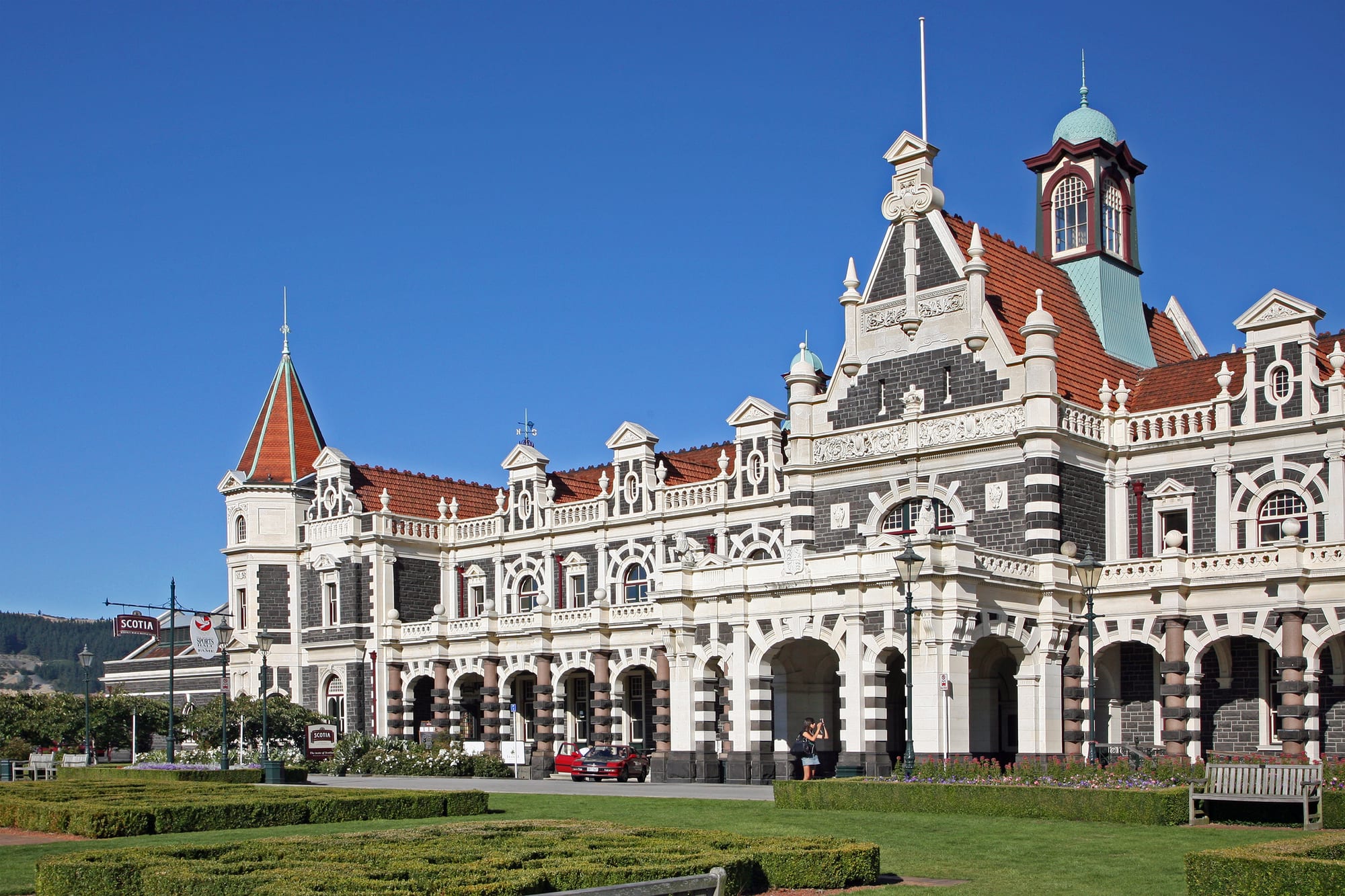
An ornate dark stone railway station with pale stone trim, red-tiled roofs, a copper-domed clock tower and clipped hedges in front, under a deep blue sky

Queenstown, Otago & Southland, New Zealand

Dunedin

Dunedin Railway Station, completed in 1906, seen across its gardens. (W. Bulach / Wikimedia Commons · CC BY-SA 4.0)

A city of about 133,000 people at the head of Otago Harbour, founded in 1848 by settlers of the Free Church of Scotland and enriched by the Otago gold rush, which for a time made it the largest and wealthiest town in New Zealand. Victorian and Edwardian stone buildings, New Zealand's oldest university and the wildlife of the Otago Peninsula define it today.

Neighbourhoods

  • The Octagon and the central city
    • First-time visitors
    • Arts and culture
    • Close to public transport

    The eight-sided plaza at the middle of the city, with the 1887 statue of Robert Burns, St Paul's Cathedral, the town hall, the public art gallery and a run of cafés and bars. George Street's shops lead north from it and the railway station, museums and waterfront lie within a short walk.

    Open in Maps
  • North Dunedin
    • Students and nightlife
    • Museums
    • Budget stays

    The university quarter, built around the bluestone clock tower of the University of Otago and the Otago Museum. Term time fills the flats, cheap eating places and bars of Castle and Albany streets with students; in the summer holidays it empties out.

    Open in Maps
  • Warehouse Precinct and Vogel Street
    • Best for food
    • Architecture
    • Bars

    A district of late 19th-century brick and stone warehouses south of the Octagon, long run down and now restored for offices, galleries, breweries, coffee roasters and restaurants. Street art covers many of the side walls.

    Open in Maps
  • St Clair and St Kilda
    • Beaches
    • Quiet and residential
    • Surfing

    Dunedin's ocean suburbs on a long sand beach a few kilometres south of the centre, with a sea wall, a surf break, an esplanade of cafés and a heated saltwater pool at St Clair. The dunes run east towards the harbour mouth.

    Open in Maps
  • Roslyn and Mornington
    • Quiet and residential
    • Views

    Hill suburbs on the slopes immediately above the city, reached by steep streets and served by small village shopping strips. They look down over the central city and the harbour, and Baldwin Street climbs from the valley behind them.

    Open in Maps
  • Otago Peninsula
    • Wildlife
    • Scenic drives
    • Quiet and residential

    A long volcanic peninsula reaching north-east from the city, with the harbourside villages of Macandrew Bay and Portobello, Larnach Castle on its ridge, and albatrosses, penguins and sea lions at its far end. Narrow roads follow both the sheltered harbour and the open coast.

    Open in Maps
  • Port Chalmers
    • Historic district
    • Arts and culture

    The deep-water port on the harbour's western shore, about 13 kilometres from the centre, where container ships and cruise liners berth. Its short main street of stone buildings has galleries, cafés and second-hand shops, and artists and musicians have long lived here.

    Open in Maps

Things to do

Famous landmarks

  • Dunedin Railway Stationlandmark

    George Troup's 1906 station in dark basalt and pale Oamaru stone, built in the Flemish Renaissance style and among the city's most prominent buildings.

    Open in Maps
  • Baldwin Streetlandmark

    A short residential street in North East Valley that Guinness World Records lists as the steepest in the world, with a gradient of about 1 in 2.86 at its worst.

    Open in Maps
  • Larnach Castlelandmark

    A mock castle opened to visitors as New Zealand's only castle, built from the 1870s for the entrepreneur and politician William Larnach high on the Otago Peninsula, with gardens and harbour views.

    Open in Maps
  • University of Otagolandmark

    New Zealand's oldest university, founded in 1869, whose 1879 clock tower building in Oamaru stone and bluestone stands beside the Water of Leith.

    Open in Maps
  • St Paul's Cathedrallandmark

    The Anglican cathedral on the Octagon, begun in 1915, with the only stone-vaulted nave in the country.

    Open in Maps
  • First Church of Otagolandmark

    The Presbyterian church of 1873 by Robert Lawson, with a tall spire, built for the congregation of the original Scottish settlement.

    Open in Maps

Museums and galleries

  • Tūhura Otago Museummuseum

    The region's main museum, opened in 1868 and renamed Tūhura Otago Museum in 2022, covering Māori and Pacific collections, natural history and a tropical butterfly house.

    Open in Maps
  • Toitū Otago Settlers Museummuseum

    A social history museum of Otago's peoples, from Kāi Tahu to Scottish and Chinese settlers, with early locomotives in its Art Deco hall.

    Open in Maps
  • Dunedin Public Art Gallerymuseum

    The country's first public art gallery, founded in 1884 and now on the Octagon, with New Zealand and European collections and changing exhibitions.

    Open in Maps
  • Dunedin Chinese Gardenattraction

    A walled Chinese scholar's garden built with the support of Dunedin's sister city Shanghai and the only authentic Chinese garden in the country, marking the Chinese miners who came for the Otago gold rush.

    Open in Maps

Parks, beaches and viewpoints

  • Dunedin Botanic Gardenpark

    New Zealand's first botanic garden, established in 1863, running from flat lawns beside the university up a hillside of rhododendrons and native bush.

    Open in Maps
  • Tunnel Beachbeach

    Sandstone cliffs, arches and stacks south-west of the city, reached by a steep farm track and a tunnel cut through the rock in the 1870s.

    Open in Maps
  • Mount Cargillviewpoint

    The forested hill of about 680 metres behind the city, with a road to a summit lookout over Dunedin, the harbour and the peninsula.

    Open in Maps

Wildlife and the harbour

  • Taiaroa Headattraction

    The headland at the tip of the Otago Peninsula, home to the only mainland breeding colony of northern royal albatross, along with shags, seals and a 19th-century coastal gun battery.

    Open in Maps
  • Sandfly Baybeach

    A wide surf beach below high dunes on the peninsula's ocean side, where sea lions haul out and yellow-eyed penguins come ashore in the evening.

    Open in Maps
  • Orokonui Ecosanctuaryattraction

    A fenced valley of native forest north of the city where takahē, kākā, tuatara and other species live free of introduced predators.

    Open in Maps
  • Otago Harbourattraction

    The long, narrow inlet the city sits on, with a shoreline cycle and walking path, small boat harbours and wildlife cruises towards the heads.

    Open in Maps

Short trips from the city

  • Moeraki Bouldersattraction

    Spherical grey boulders, some nearly two metres across, exposed by the sea on a beach on the North Otago coast.

    Open in Maps
  • Nugget Pointviewpoint

    A narrow headland south of the city with a lighthouse of 1869 and a chain of rock stacks in the surf, at the northern end of the Catlins coast.

    Open in Maps
  • Taieri Gorgeattraction

    A steep rock gorge inland from the city, crossed by viaducts and tunnels on the railway line that carries tourist trains from Dunedin.

    Open in Maps

Seasonal events

  • Dunedin Fringe FestivalMarch

    Eleven days of theatre, comedy, dance, music and visual art in venues across the central city.

  • iD Dunedin Fashion Weekautumn

    A fashion week built around an emerging designer award and a runway show staged on the railway station platform, one of the longest catwalks anywhere.

  • Midwinter CarnivalJune

    A lantern procession through the central city around the winter solstice, with large illuminated sculptures made in community workshops.

  • Otago Farmers MarketSaturday mornings, all year

    Growers, fishers, bakers and coffee carts fill the carpark beside the railway station each Saturday morning.

Eat and drink

Long-standing places and food districts in Dunedin. Hours, ratings and directions come from your maps app, always current.

Dunedin classics

  • Cheese rollsrestaurant

    The southern staple found in cafés and bakeries across the city — a slice of bread spread with a cheese and onion mixture, rolled and toasted, and known locally as southern sushi.

    Open in Maps
  • Speight's Breweryrestaurant

    The brewery on Rattray Street that has made beer since 1876, with a visitor tour and an adjoining alehouse; its bitter is a southern institution.

    Open in Maps

Food districts and markets

  • Otago Farmers Marketmarket

    A Saturday producers' market at the railway station, strong on Otago vegetables, cheese, salmon, whitebait in season and blue cod.

    Open in Maps
  • Warehouse Precinct and Vogel Streetneighborhood

    Restored warehouses south of the Octagon holding restaurants, craft breweries, coffee roasters and bakeries.

    Open in Maps
  • George Street and the Octagonneighborhood

    The main shopping street and the central plaza, lined with cafés, pubs, Asian and Middle Eastern places and the city's more formal dining rooms.

    Open in Maps
  • St Clair Esplanadeneighborhood

    Cafés and small restaurants facing the surf at the beach suburb, a Dunedin habit for weekend breakfast.

    Open in Maps

Experience Dunedin

History

Kāi Tahu and earlier peoples knew the harbour as Ōtākou, a name later applied to the whole province, and had settlements around its shores and at Ōtākou village on the peninsula. Sealers and whalers arrived from the 1810s, and a whaling station operated at Ōtākou in the 1830s. In March 1848 the ship John Wickliffe reached the harbour carrying the first settlers of the Otago scheme, organised by the Lay Association of the Free Church of Scotland; the town was named Dunedin from Dùn Èideann, the Gaelic name for Edinburgh, and laid out on a plan that ignored the hills it had to cross.

The settlement was small and poor until gold was found at Gabriel's Gully in 1861. Thousands of miners passed through the port, and the money they brought made Dunedin briefly the largest and richest town in New Zealand, with the country's oldest daily newspaper, its first university, founded in 1869, and its first brokers' association. Banks, warehouses and churches went up in Oamaru limestone and dark Port Chalmers basalt, and the wealth paid for the botanic garden and Larnach Castle. In 1882 the refrigerated ship Dunedin sailed from Port Chalmers with the first successful cargo of frozen meat to Britain.

As the gold faded and the North Island grew, the city slipped down the national rankings, and through much of the 20th century it lost industry and young people. What it kept was its Victorian and Edwardian building stock, largely because there was no boom to replace it, and its university. Since the 1990s the warehouse district has been restored, the roofed Forsyth Barr Stadium opened in 2011, and the harbour edge has been reworked for walking and cycling.

Culture & Customs

Dunedin wears its Scottish descent openly: a statue of Robert Burns has stood in the Octagon since 1887, pipe bands play at civic events, and Presbyterian churches stand on prominent corners. The city also carries a strong Kāi Tahu presence, with the marae at Ōtākou on the peninsula and southern dialect names across the map.

It is above all a university town. Students at the University of Otago and the polytechnic make up a large share of the population, and student life — flats with names painted over the door, the annual capping show, graduation processions through the streets — sets the rhythm of the year. That population helped produce the Dunedin sound of the early 1980s, the guitar-based indie music of bands recorded by the Flying Nun label, which gave the city a reputation in music far beyond its size. In 2014 UNESCO named Dunedin a City of Literature, recognising a long line of writers, the Robert Burns Fellowship and a strong publishing and library tradition.

Rugby matters: the Highlanders and Otago play under the roof at Forsyth Barr Stadium, where a student stand keeps the noise up, and the rivalry with Canterbury is old and sharp. Beyond that the culture is outdoor and unpretentious — surfing at St Clair in cold water, tramping on the hills behind the city, and a widely shared pride in the wildlife living on the doorstep.

Daily Life

About 133,000 people live in the Dunedin city area, making it New Zealand's seventh-largest urban area and the largest city in the south of the South Island. The University of Otago, the polytechnic and Dunedin Hospital are the biggest employers, and health, education, research and public administration dominate the economy alongside engineering, food processing and a growing technology and games development sector. Tourism, cruise ships and the port at Port Chalmers add to it.

Most people live in suburbs spread over the hills and valleys around the harbour — the flat, older streets of South Dunedin and the beach suburbs, the villas of Roslyn and Maori Hill above the centre, and newer housing in North East Valley and Mosgiel on the Taieri Plain. Students concentrate in the old villas of North Dunedin, whose cold, damp flats are a recurring local controversy. Housing is cheap by national standards, though prices have risen sharply.

The rhythm of the year follows the university: quiet in January, crowded from late February, with graduation weeks and match days filling the centre. Current issues include the long-delayed rebuild of Dunedin Hospital, the population decline in nearby rural districts, and what to do about South Dunedin, a low suburb built on drained swamp where a rising water table and sea level make flooding steadily more likely.

Food

Dunedin's most characteristic food is the cheese roll, shared with the rest of the south: white bread spread with a mixture of grated cheese, onion soup mix and evaporated milk or cream, rolled up and toasted until it browns, served hot with butter. Cafés compete quietly over them. The other southern delicacy is the Bluff oyster, dredged from Foveaux Strait and sold in fish shops and restaurants through autumn and winter, usually raw or lightly crumbed and fried.

The coast supplies blue cod, the standard fish in a Dunedin fish and chip shop, along with muttonbird, or tītī, sold in season to those who know how to cook its strong, salty meat, and whitebait fritters in spring. Otago lamb and venison, Central Otago stone fruit and pinot noir, and cheeses from the surrounding districts appear on restaurant menus and at the Saturday farmers' market at the railway station, which has become the city's weekend social event as much as a shop.

Beer is part of the identity. Speight's has brewed on Rattray Street since 1876, and its draught is ordered by name across the south; Emerson's, founded in the city in 1992, is one of the country's craft-brewing pioneers and has a brewery and bar of its own. Coffee roasting is taken seriously in the warehouse district. Chocolate is a sentimental subject: the Cadbury factory that scented the city centre for decades closed in 2018, but the Jaffa-rolling charity race down Baldwin Street has continued each July, and local confectioners continue to trade on the association.

Planning tools

Budget

Dunedin is considerably cheaper than Queenstown, with motels, holiday parks, hostels and student-city prices for food and drink. Accommodation is the main variable: rooms tighten and rise for graduation weeks, big rugby matches and stadium concerts, and around Easter. Wildlife tours on the Otago Peninsula and the tourist train are the largest single costs for most visitors.

Daily Budget Midrange
USD 150–280 (motel or hotel room, restaurant meals, a hire car, one wildlife tour)
Daily Budget Shoestring
USD 55–95 (hostel bed or holiday park, supermarket and bakery food, city buses)

Museums and the art gallery ask only for donations, and the beaches, botanic garden and harbour path cost nothing.

Best Time to Visit

October to April is the mildest stretch, and December to February the warmest and busiest, with long southern evenings, penguins and albatross chicks on the peninsula and cruise ships at Port Chalmers. Autumn brings colour to the botanic garden and quieter roads. Winter is cold and short on daylight but rarely snowy at sea level, and the museums, pubs and indoor stadium carry the season.

Suggested Number of Days

Two to three days suits the central city and one trip out along the Otago Peninsula. Four or five allow the wider coast and the inland valleys as well. Wildlife tours are tide- and time-dependent, so an extra day gives flexibility if the weather turns.

First Visit
2–3 days
With Surroundings
4–5 days

Transportation

The Orbus city bus network runs from a central hub on Great King Street to the suburbs, the beaches and out along the harbour, using a stored-value card or contactless payment. A car is the practical way to reach the far end of the peninsula, Tunnel Beach and Mount Cargill, since bus services there are limited. Taxis and ride-hailing operate in the city, and tour operators run trips to the albatross colony and the Taieri Gorge railway.

Peninsula roads are narrow and winding with blind corners, so allow far more time than the distance suggests.

Airport & Station Connections

Dunedin Airport is at Momona, about 22 kilometres south-west of the centre, roughly half an hour by road, with domestic flights to Auckland, Wellington and Christchurch; a shuttle or taxi covers the transfer, as there is no scheduled city bus. Long-distance coaches link Christchurch, Queenstown and Invercargill, and the drive from Christchurch takes about four and a half to five hours. Cruise ships berth at Port Chalmers.

Walkability

The central grid around the Octagon is flat and compact, and the railway station, museums, galleries, the university and the Warehouse Precinct are all within about twenty minutes on foot of each other. The city then rises steeply: the hill suburbs involve serious climbs, and the beaches and peninsula are too far to walk. The harbour-side shared path and the beach esplanades are the easy walks.

Safety

Dunedin is a safe city with low levels of violent crime. Student districts can be noisy and occasionally rowdy at night in term time, and opportunistic theft from parked cars happens at trailheads and lookouts. The real hazards are natural: cold water and strong rips on the ocean beaches, unfenced cliff edges on the peninsula, and sea lions resting on sand or tracks.

Leave nothing in a parked car, swim between the flags at patrolled beaches, and stay at least twenty metres from sea lions and penguins. Check current official travel advice before travelling.

Climate

Cool temperate and changeable, with sea fog, brisk southerlies and four seasons in a day a genuine local complaint. Rainfall is moderate and spread through the year, and snow at sea level is uncommon. In the southern hemisphere summer falls in December to February and winter in June to August.

Summer
mild rather than hot — daytime highs usually 17–21°C, cooler when the wind swings south
Winter
cold and grey — highs of about 10–12°C, frequent frosts overnight and short daylight hours

Local Customs

Manners are informal and understated, and first names are used quickly. Tipping is not expected and service charges are rare. The Scottish inheritance shows in place names, pipe bands and Burns suppers, and Kāi Tahu, the southern iwi, is acknowledged in greetings and place names, where the southern dialect uses k where northern Māori uses ng. Shoes often come off at the door of a home.

Buying alcohol requires photo identification and the legal age is 18; on marae and at wildlife sites follow the guide's instructions, and do not photograph people or penguins with a flash.

Common Payment Methods

The currency is the New Zealand dollar. Cards and contactless payment work almost everywhere, including on buses, and some cafés take no cash at all; a surcharge on credit cards or on public holidays is normal and must be disclosed. ATMs are in the central city and suburban shopping strips, and little cash is needed beyond markets and small tours.