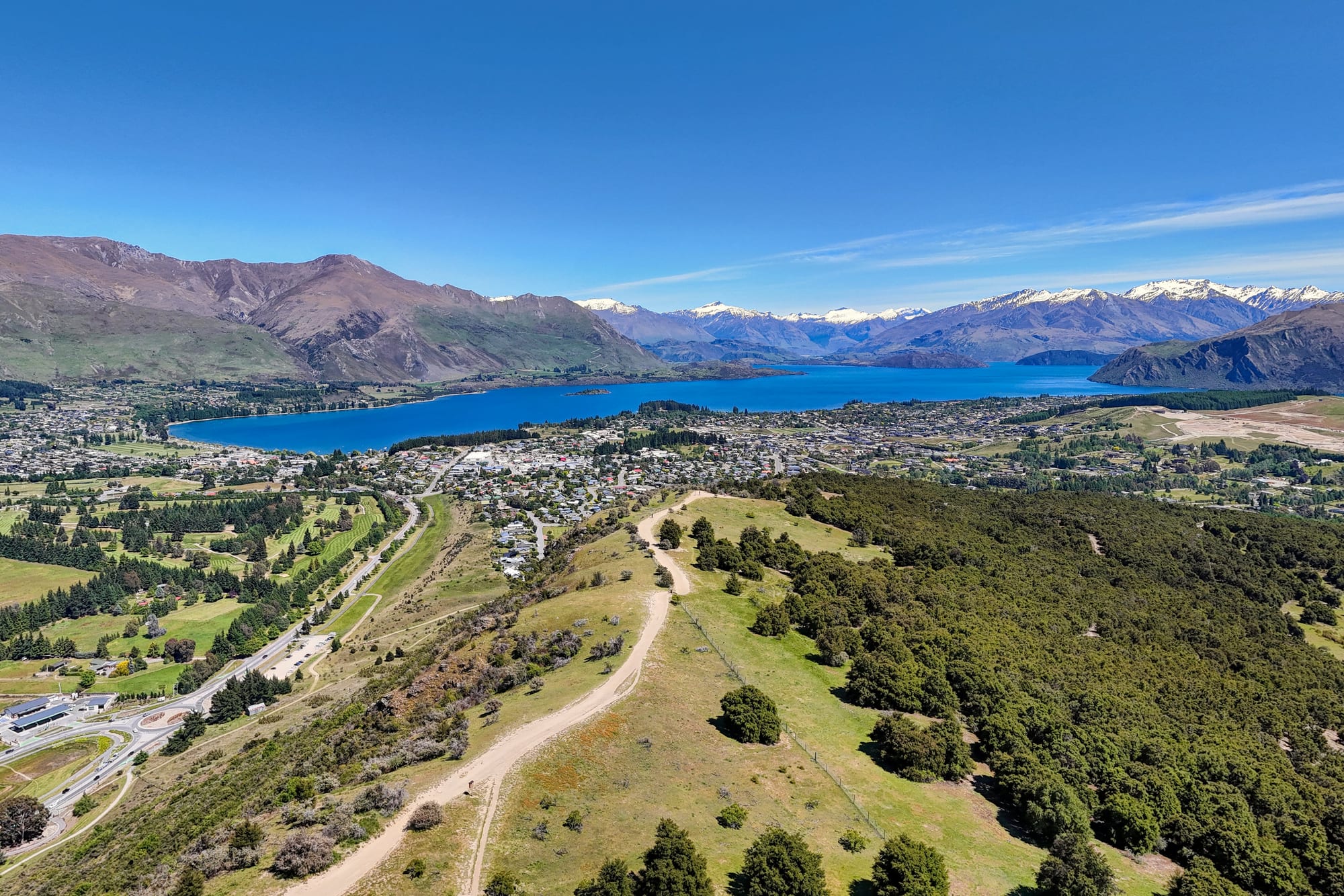
A deep blue lake seen from above, with brown hills in front and snow-covered mountains at the far end

Queenstown, Otago & Southland, New Zealand

Wānaka

Lake Wānaka, seen from the hills above the town at its southern end. (Hagai Agmon-Snir / Wikimedia Commons · CC BY-SA 4.0)

A lake town in Central Otago at the southern end of Lake Wānaka, an hour from Queenstown over the Crown Range and at the doorstep of Mount Aspiring National Park. A service settlement for sheep stations and goldfields that became a holiday town, it is quieter and more residential than Queenstown, and lives on walking, skiing, cycling and the lake.

Neighbourhoods

  • The town centre and lakefront
    • First-time visitors
    • Best for food
    • Walks

    Ardmore Street runs along the water with cafés, bars, outdoor shops and a cinema behind a grassy lakeside reserve, a beach and a jetty. Most of the town's restaurants and many of its hotels are within a few hundred metres, and the lakeside path leads out of town in both directions.

    Open in Maps
  • Beacon Point and the northern shore
    • Quiet and residential
    • Lake views

    Houses and holiday homes on the low ridge north-east of the centre, above the beaches and shoreline tracks. It is a walk or cycle of twenty minutes or so into town along the water, with a small shop at Roys Bay.

    Open in Maps
  • Albert Town
    • Quiet and residential
    • Camping
    • Families

    A settlement about five kilometres east at the confluence of the Clutha and Hāwea rivers, with a campsite on the river terrace, a school, a small shopping strip and easy access to the river tracks and the Hāwea road.

    Open in Maps
  • Glendhu Bay and the Mount Aspiring road
    • Camping
    • Boating
    • Mountain views

    West of the town the road follows the lake to Glendhu Bay, with a long-established lakeside holiday park, and continues into the Matukituki Valley towards Mount Aspiring National Park. Baches and lodges are scattered along it.

    Open in Maps
  • Lake Hāwea
    • Quiet and residential
    • Boating
    • Camping

    A smaller township on a separate lake about 15 kilometres north, with a hotel, a store, a holiday park and a long shingle foreshore. It is cheaper than Wānaka and a common base for the Hāwea and Makarora valleys.

    Open in Maps
  • Cardrona Valley
    • Skiing
    • Historic district

    The valley road south of the town climbs past a gold-rush hotel and settlement to the Cardrona ski field and the Snow Farm, then over the Crown Range to Queenstown. Chalets and lodges line the lower valley.

    Open in Maps

Things to do

The lake and the shore

  • Lake Wānakaattraction

    A long glacial lake of nearly 200 square kilometres, 42 kilometres long and more than 300 metres deep in places, with islands, cold clear water and mountains at its northern end.

    Open in Maps
  • That Wānaka Treelandmark

    A willow growing alone in the shallows at the lake's southern end, one of the most photographed trees in New Zealand, a few minutes' walk west of the town centre.

    Open in Maps
  • Wānaka lakefront tracktrail

    A flat walking and cycling path along the shore from the centre past beaches and the willow tree towards Waterfall Creek and Glendhu Bay.

    Open in Maps
  • The lakefront beachesbeach

    Sheltered swimming bays along the shore a short walk or ride from the centre, with lawns, shade and views down the lake.

    Open in Maps

Walks and viewpoints

  • Roys Peaktrail

    A steep, exposed full-day climb from the Glendhu Bay road to a ridge with the well-known view over the lake and its islands.

    Open in Maps
  • Mount Irontrail

    A rounded rock knoll on the edge of the town, an hour's loop walk to a summit looking over Wānaka, Albert Town and the Cardrona Valley.

    Open in Maps

Mount Aspiring and the valleys

  • Mount Aspiring National Parkpark

    A park of glaciers, beech forest and river valleys west and north of the town, part of the Te Wāhipounamu World Heritage Site.

    Open in Maps
  • Tititea / Mount Aspiringviewpoint

    The high pyramid peak at the head of the Matukituki, 3,033 metres and the highest mountain in New Zealand outside the Aoraki / Mount Cook National Park region.

    Open in Maps
  • Rob Roy Glacier Tracktrail

    A day walk up a side valley of the West Matukituki through beech forest to a hanging glacier and waterfalls, reached by a gravel road with fords.

    Open in Maps
  • Blue Poolsattraction

    Clear, pale-blue pools where the Blue River meets the Makarora, reached by a short forest walk and a swing bridge from the Haast Pass highway at the head of Lake Wānaka.

    Open in Maps

Skiing and the Cardrona Valley

  • Treble Coneattraction

    One of the South Island's largest ski fields, with the longest vertical rise in the Southern Lakes district, on steep terrain above the lake west of the town and known for its off-piste basins and lake views.

    Open in Maps
  • Cardrona Alpine Resortattraction

    A ski field on a high plateau in the Cardrona Valley, the largest commercial ski field in New Zealand, with wide beginner terrain, terrain parks and its own accommodation.

    Open in Maps
  • Cardrona Hotellandmark

    A gold-rush hotel of the 1860s with a preserved timber facade, almost all that is left of the mining settlement in the valley.

    Open in Maps

Museums and attractions

  • Puzzling Worldattraction

    A long-running attraction on the Cromwell road with a large outdoor maze, tilted rooms and illusion galleries, a fixture for families since the 1970s.

    Open in Maps
  • National Transport and Toy Museummuseum

    A very large private collection of vehicles, aircraft and toys in hangars beside Wānaka Airport, east of the town.

    Open in Maps
  • Ripponattraction

    A vineyard on the slopes above the lake west of the centre, known as much for its view over the water as for its wine, and the site of a biennial music festival.

    Open in Maps

Seasonal events

  • Warbirds Over WanakaEaster, in even-numbered years

    An international airshow at Wānaka Airport featuring historic military aircraft, held every second Easter since 1988.

  • Wānaka A&P Showautumn

    The district's agricultural and pastoral show, held since 1934, with stock judging, shearing, wood chopping and sideshows on the showgrounds.

  • Festival of Colourautumn, in alternate years

    A festival of theatre, music, dance and talks staged in the town's venues, with a companion programme for children.

  • Ski seasonJune to September

    Treble Cone, Cardrona and the Snow Farm open as the snow builds, and the town fills with skiers, snowboarders and seasonal staff.

Eat and drink

Long-standing places and food districts in Wānaka. Hours, ratings and directions come from your maps app, always current.

Where to eat in Wānaka

  • Ardmore Street and the lakefrontneighborhood

    The waterfront strip and the lanes behind it hold most of the town's cafés, bakeries, pizza places, brewpubs and restaurants, several with tables facing the lake.

    Open in Maps
  • Cardrona Hotelrestaurant

    The 1860s hotel in the Cardrona Valley, a long-standing stop for a meal or a drink in its garden on the way to or from the ski fields.

    Open in Maps

Vineyards and provisions

  • Wānaka cellar doorsneighborhood

    A small group of vineyards on the terraces around the lake and on the Cromwell road, pouring Central Otago pinot noir, riesling and pinot gris, several with food to match.

    Open in Maps
  • Cromwell fruit stallsmarket

    Roadside stalls and orchard gates in the Cromwell basin an hour south-east sell cherries, apricots, peaches and nectarines through the summer.

    Open in Maps
  • Wānaka supermarkets and butchersmarket

    The town has full supermarkets and butchers selling Central Otago lamb, beef and venison — the usual stop before a valley road or a hut trip.

    Open in Maps

Experience Wānaka

History

Kāi Tahu travelled to the lakes on seasonal journeys, camping at the outlet of Lake Wānaka and moving inland for eels, weka and other food and along trails towards the pounamu of the west coast. The name is the South Island dialect form of wānanga, meaning sacred knowledge or a place of learning; an early settler derivation from Oanaka is disputed by Ngāi Tahu, and the macron was restored to the spelling in recent years. European runholders took up the dry country around the lake from the late 1850s, and the Otago gold rush of the 1860s brought miners to the Cardrona Valley and the Clutha River, leaving hotels, stone cottages and water races behind.

For most of its first century the settlement, long called Pembroke, was a small service centre for sheep stations and a summer camping spot for Otago families. Boats carried timber and goods on the lake, roads were slow and the Haast Pass route north was not fully open to vehicles until the 1960s. The town dropped the name Pembroke in 1940 and its lakefront filled with baches, holiday houses and a camping ground on the reserve.

Skiing and climbing changed it. Mount Aspiring National Park was created in 1964 around the peak the surveyors called Aspiring and Kāi Tahu know as Tititea, drawing mountaineers to the Matukituki, and commercial ski fields opened in the Cardrona Valley and at Treble Cone in the 1970s and 1980s, giving the town a winter season. The airshow at the airport, first held in the late 1980s, and the tourism boom that followed Queenstown's brought steady growth, and since the 1990s Wānaka has been one of the fastest-growing towns in New Zealand, with new subdivisions spreading east over the flats.

Culture & Customs

Wānaka's identity is built on the outdoors and on not being Queenstown. There is no bungy operator in the middle of town and the nightlife is modest; instead the town is full of people who came for a season of skiing or climbing and stayed, of families who moved from the cities for the lake, and of visitors who walk, cycle, swim and ski. Mountaineering has deep roots here, with the Matukituki huts and Mount Aspiring as a training ground for generations of climbers, and the local search and rescue teams are a point of community pride.

The cultural calendar is small but distinct: a biennial airshow that brings historic aircraft and large crowds to a town of this size, a biennial arts festival, the agricultural and pastoral show held since 1934, and a long-standing cinema known for its sofas and home baking. Central Otago's gold-rush heritage survives in the Cardrona Valley, where an 1860s hotel and a few cottages are all that remain of a mining settlement.

Residents are protective of the lakefront and the views, and the growth of the town is the standing argument — over subdivisions, traffic, freedom camping and the number of visitors on tracks such as Roys Peak. Conservation groups run predator trapping and native planting around the lakes. The etiquette expected of visitors is simple and firmly held: stay on the tracks, pick up after dogs, take rubbish out, and do not park on the grass.

Daily Life

Wānaka's urban area has grown to about 13,000 residents, and with Albert Town, Lake Hāwea and the surrounding countryside the Upper Clutha holds several thousand more. Growth has been rapid for three decades, and the built-up area now runs well east of the old centre into new subdivisions with their own schools and shops. Visitor numbers in peak weeks and the share of houses used as holiday homes make the resident population feel smaller than it is.

The economy is tourism, construction and services, with farming on the terraces and vineyards and orchards towards Cromwell. The ski fields, activity operators, hotels, cafés and the airport employ a large share of the workforce, and building has been a constant industry as the town expands. Many households combine seasonal work with something else, and a significant number of residents work remotely or commute to Queenstown.

Housing cost is the dominant local issue: prices and rents are among the highest in the country relative to local wages, and seasonal staff struggle to find rooms. Traffic on the two roads into town, pressure on the lakefront and water quality in the lakes are debated alongside it. Everyday life is outdoors — school sport, swimming off the jetty in summer, skiing after work in winter, running and cycling on the tracks — with hospital care and larger shopping a drive to Queenstown, Cromwell or Dunedin.

Food

Wānaka eats well for its size, on Central Otago produce and with a strong café culture. The region's stone fruit is the great local ingredient: cherries, apricots, peaches and nectarines from the Cromwell basin, sold from roadside stalls through the summer and turned into tarts, ice cream and jam. Lamb and merino from the high-country stations, farmed red deer venison, salmon from the Mackenzie canals and Central Otago vegetables fill the restaurant menus, and Bluff oysters and blue cod come up from the south in season.

Everyday food is New Zealand casual — bakery pies, fish and chips, burgers, brunches of eggs and sourdough, and flat whites taken seriously. A few restaurants on and behind Ardmore Street work at a higher level, and there are Thai, Japanese and Italian kitchens, pizza places and brewpubs. Mountain food matters too: the bakeries and supermarkets are where walkers and climbers stock up before the Matukituki valleys and the huts.

Drink is Central Otago's strength. The district is part of the world's southernmost commercial wine region, and vineyards on the lake terraces around Wānaka and in the Cromwell basin make pinot noir, riesling, pinot gris and sparkling wine; several cellar doors are a short drive from the town. Craft breweries operate in and near the town, cider is pressed from Central Otago orchards, and a distillery or two produce gin and whisky. Mulled wine and hot chocolate belong to the ski season.

Planning tools

Budget

Wānaka is expensive by New Zealand standards but usually a little less than Queenstown, and it has more self-contained houses and holiday parks than hotels. Peak prices come at New Year, in the school holidays and in the ski season. Many of the best things to do — the lakefront, Mount Iron, Roys Peak, the beaches and the valley roads — cost nothing beyond transport.

Daily Budget Midrange
USD 170–310 (motel, apartment or lodge, restaurant meals, a hire car, one paid activity)
Daily Budget Shoestring
USD 60–100 (hostel bed or holiday park, supermarket food, walking and local buses)

Beds are scarce and dear at New Year and in July and August, and Lake Hāwea, Albert Town and Cromwell are cheaper alternatives.

Best Time to Visit

December to March for the lake, the long evenings and the high tracks, with the warmest water in February. April brings autumn colour and settled, cool weather; June to September is the ski season, cold and often bright, with frost and occasional snow in the town. Late spring can still have snow on the ridges and cold water.

Suggested Number of Days

Two or three days suits the town, the lake and a long walk. Five or six allow for the national park valleys, the neighbouring lake and Central Otago, or for several days on the ski fields. Weather on the tops is the main reason to allow spare time.

First Visit
2–3 days
With Surroundings
5–6 days

Transportation

The centre is small and flat, and a network of lakeside and river tracks links the town to Albert Town, the airport area and Glendhu Bay for walkers and cyclists. There is a local bus service and a connection over the Crown Range to Queenstown, and ski buses run in winter, but most visitors have a car, which is needed for the Matukituki and Hāwea valleys. Bikes, kayaks and paddleboards are hired in the town.

Roads to the national park valleys are gravel with unbridged fords that rise quickly in rain, and hire-car agreements often exclude them; chains may be required on the ski-field roads in winter.

Airport & Station Connections

Wānaka is about 70 kilometres from Queenstown by the Crown Range road, an hour and a quarter in good conditions, or about 120 kilometres by the Cromwell highway, which is the safer winter route. Cromwell is about 50 kilometres south-east and Christchurch around five and a half hours by road. Wānaka Airport, east of the town, handles scenic flights and general aviation rather than scheduled airline services, so most arrivals fly into Queenstown and drive or take a shuttle.

Walkability

The town centre is compact and level: the lakefront, the shops, the cinema and the park are all within a few blocks, and the willow tree is a twenty-minute walk along the shore. Residential areas spread up the slopes to the east and north, so some accommodation involves a climb. Footpaths and separated cycle tracks are good near the lake and thin out on the highways.

Safety

The town is safe and crime is low, with theft from parked cars at trailheads the main nuisance. The hazards are outdoors: the lake is cold and deep, Roys Peak and the high tracks are exposed with no shade or water, river fords in the Matukituki can become impassable, and the ski fields have avalanche terrain. Summer sun at this altitude burns quickly.

Water, sun protection and a warm layer belong in any day pack, trailhead cars should be left empty, river levels and avalanche forecasts are worth checking before setting out, and intentions should be left with someone. Check current official travel advice before travelling.

Climate

A dry, sunny inland climate with wide daily swings, sheltered by the mountains to the west. Summer is December to February in the southern hemisphere. Frosts are frequent from autumn to spring, and the lake moderates the town a little compared with Central Otago's inland basins.

Summer
warm and dry, with days often 22–27°C and cool nights; light until after nine o'clock
Winter
cold and often clear, with days around 5–10°C, hard frosts, some snow in the town and much more on the ski fields

Local Customs

Wānaka thinks of itself as the quieter, more residential alternative to Queenstown, with a strong outdoor culture of climbers, skiers, cyclists and runners, and a settled community of families and retirees alongside seasonal staff. Dress is outdoor casual, dogs are everywhere on the lakefront, and the tracks have an etiquette of greeting and giving way. Kāi Tahu history runs through the lakes and the pounamu trails, and place names across the district are Māori.

Tipping is not expected. Identification is required to buy alcohol, freedom camping is restricted and enforced around the lake, drones are limited near the lakefront and the airport, and farm gates on walking tracks should be left as they were found.

Common Payment Methods

The currency is the New Zealand dollar. Cards and contactless payment are accepted in shops, cafés, ski fields and activity offices, and ATMs are in the town centre. A small amount of cash is useful for roadside fruit stalls, honesty boxes at farm gates and Department of Conservation campsites.