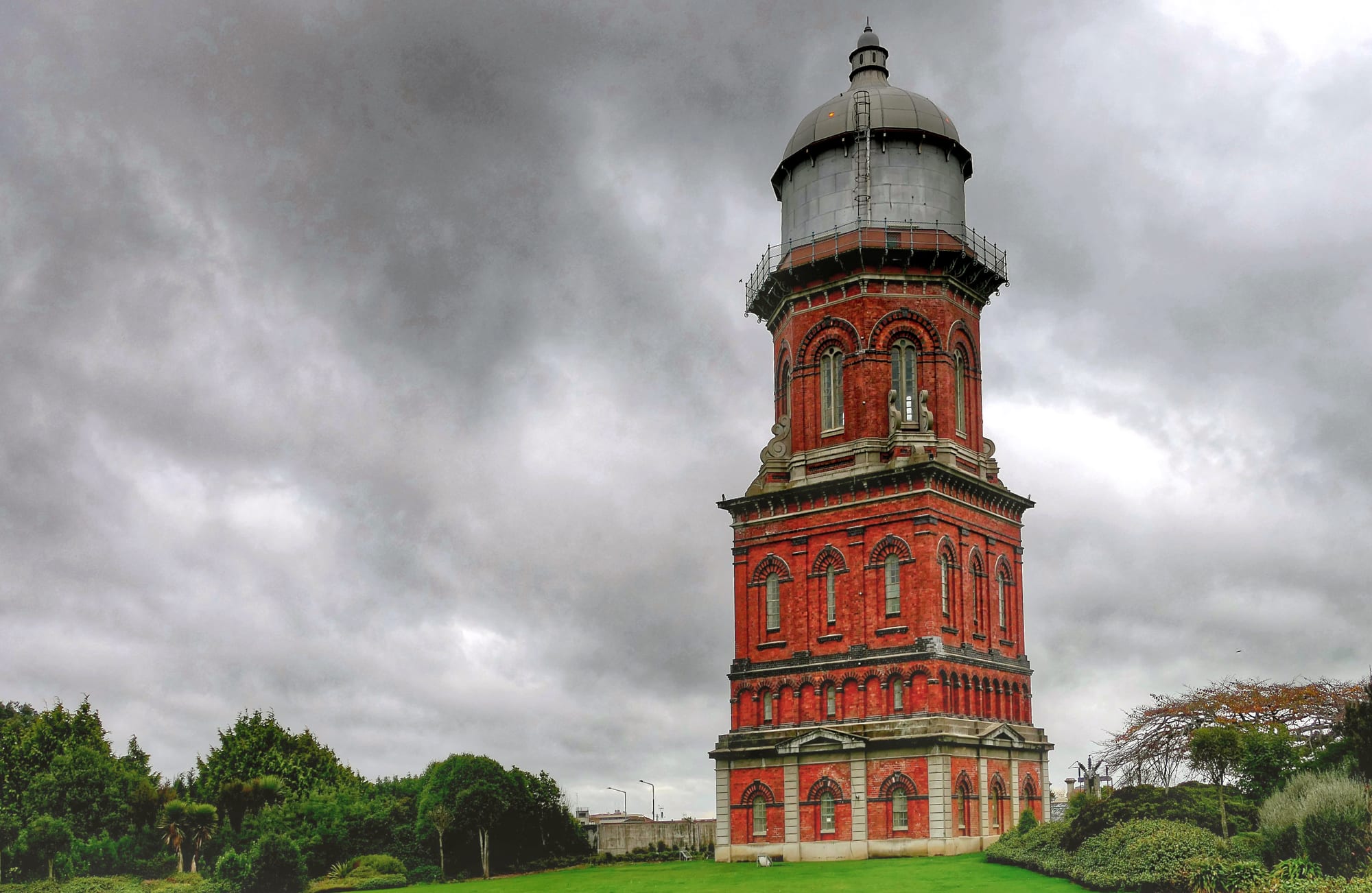
A tall octagonal red-brick Victorian water tower with a domed metal top, standing on mown grass under heavy grey cloud

Queenstown, Otago & Southland, New Zealand

Invercargill

The 1889 water tower, Invercargill's best-known landmark. (Bernard Spragg. NZ / Wikimedia Commons · Public domain)

New Zealand's southernmost city and the commercial centre of Southland, with about 55,000 people on the flat plain behind Oreti Beach. Founded in the 1850s and laid out on a wide grid of streets named after Scottish rivers, it lives on farming, meat and dairy processing and the aluminium smelter at Tiwai Point near Bluff, and is the mainland gateway to Stewart Island.

Neighbourhoods

  • City centre
    • First-time visitors
    • Shops
    • Close to public transport

    The grid around Dee and Tay streets, unusually wide and flat, with Edwardian brick and stone frontages, the transport museums, department stores, cafés and most of the city's hotels and motels. Bus routes and long-distance coaches use the centre, and the water tower stands a few blocks away.

    Open in Maps
  • Queens Park and Gladstone
    • Families
    • Parks
    • Quiet and residential

    The large central park and the streets of older villas and bungalows around it, north of the shopping district. The park holds a botanical garden, an aviary, an animal reserve, an 18-hole golf course and stands of mature trees, and the neighbouring suburb is one of the city's most settled.

    Open in Maps
  • Windsor and Waikiwi
    • Quiet and residential
    • Local life

    Northern suburbs along the road out towards Queenstown, with small shopping strips, schools and post-war housing. They are convenient for the airport side of the city and for driving north without crossing the centre.

    Open in Maps
  • Otatara and Sandy Point
    • Nature
    • Quiet and residential
    • Beaches

    A leafy semi-rural area west of the city across the New River Estuary, where houses sit among native bush, next to the reserve and walking tracks of Sandy Point and the long sweep of Oreti Beach.

    Open in Maps
  • Ascot and the south
    • Sport
    • Budget stays

    The southern approach to the city, with motels along the highway, the racecourse and sports grounds, and the road running on towards Bluff, the smelter and the Stewart Island ferry.

    Open in Maps

Things to do

Landmarks and parks

  • Invercargill Water Towerlandmark

    An ornate brick tower of 1889 built to hold the city's first high-pressure water tank, designed by the consulting engineer William Sharp.

    Open in Maps
  • Queens Parkpark

    About 80 hectares of park just north of the city centre, part of the original 1856 town plan, with a botanical garden, an aviary, an animal reserve of wallabies and alpacas, an observatory and sports grounds.

    Open in Maps
  • St Mary's Basilicalandmark

    A Catholic basilica in Tyne Street designed by Francis Petre and opened in 1905, rising 37 metres and one of the city's most prominent landmarks.

    Open in Maps
  • Invercargill Civic Theatrelandmark

    An Edwardian Neo-Baroque building of 1906 in Tay Street, a Category I historic place, used for touring productions and local performance.

    Open in Maps

Motoring museums

  • Bill Richardson Transport Worldmuseum

    A very large private collection of trucks, cars and petrol-station memorabilia assembled by a Southland transport family, displayed in a complex of some 15,000 square metres opened to the public in 2015.

    Open in Maps
  • Classic Motorcycle Meccamuseum

    A city-centre collection of more than 300 motorcycles, mostly British and American, the largest motorcycle display in New Zealand, run by Transport World.

    Open in Maps
  • Burt Munro's Indian at E Hayes and Sonsattraction

    The 1920 Indian Scout that the Invercargill engineer Burt Munro modified and rode to a land-speed record at Bonneville in 1967, displayed with about a hundred other vehicles among the stock of a working hardware store.

    Open in Maps

Coast, estuary and nature

  • Oreti Beachbeach

    A 26-kilometre sweep of exposed sand about ten kilometres west of the city, firm enough to drive on, where Burt Munro practised riding the Indian he later took to Bonneville.

    Open in Maps
  • Sandy Pointtrail

    A reserve of native bush, dunes and estuary edge between the city and Oreti Beach, with walking, running and mountain-bike tracks and a rowing course on the Oreti River.

    Open in Maps
  • Waituna Lagoonattraction

    A coastal lagoon east of the city, part of the Awarua Wetland Ramsar site, with more than seventy bird species recorded.

    Open in Maps
  • New River Estuaryattraction

    The broad tidal estuary on the city's western edge, a feeding ground for shorebirds at low tide, with the airport built on land reclaimed from it in 1938.

    Open in Maps

Sport and events venues

  • ILT Stadium Southlandattraction

    The city's indoor arena at Surrey Park, home ground of the Southern Steel netball and Southland Sharks basketball teams, with the velodrome opened in 2006 alongside it that has made Southland a centre for track cycling.

    Open in Maps
  • Rugby Parkattraction

    The ground where Southland's provincial rugby team plays, opened in 1908, a serious matter in a farming province.

    Open in Maps

Short trips from the city

  • Bluffattraction

    The port town about half an hour south by road, with the oyster fleet, Bluff Hill / Motupohue above the harbour and the ferry to Stewart Island.

    Open in Maps
  • Stirling Pointviewpoint

    The southern end of State Highway 1 at Bluff, marked by a much-photographed signpost and an anchor-chain sculpture, and the southern end of the Te Araroa trail.

    Open in Maps
  • Rivertonattraction

    A small fishing and holiday town on an estuary west of the city, the oldest permanent settlement in Southland, with beaches and a local heritage museum.

    Open in Maps
  • Curio Bayattraction

    A bay on the Catlins coast east of the city where a petrified forest some 180 million years old is exposed at low tide and yellow-eyed penguins come ashore.

    Open in Maps
  • Goreattraction

    A Southland town north-east of the city on the Mataura River, the home of New Zealand's country music awards.

    Open in Maps

Seasonal events

  • Burt Munro Challengesummer

    Several days of motorcycle racing and events, run by the Invercargill Motorcycle Club since 2006 in memory of the city's record-breaking rider.

  • Bluff Oyster and Food Festivalautumn

    The annual oyster festival at Bluff, down the road from the city, with seafood stalls and the strait's most famous shellfish at the centre of it.

  • Gold Guitar AwardsJune

    New Zealand's country music awards, held at Gore north-east of the city every June since 1974 as part of the town's Tussock Country festival.

Eat and drink

Long-standing places and food districts in Invercargill. Hours, ratings and directions come from your maps app, always current.

Southland specialities

  • Bluff oystersrestaurant

    Dredged from Foveaux Strait between March and August and sold at fish shops and restaurants in the city; they are eaten raw, crumbed and fried, or in a pie.

    Open in Maps
  • Cheese rollscafe

    The Southland snack sometimes called southern sushi — bread spread with a mixture of grated cheese, onion soup mix and cream, rolled and toasted, served hot with butter.

    Open in Maps
  • Blue cod and whitebaitrestaurant

    Blue cod is the standard fish in a Southland takeaway, and whitebait fritters appear in spring when the season opens on the local rivers.

    Open in Maps

Where people eat and drink

  • Dee and Tay streetsneighborhood

    The central grid holds most of the city's cafés, bakeries, pubs and Asian, Indian and Italian restaurants, several in old bank and warehouse buildings.

    Open in Maps
  • Bluff seafoodneighborhood

    Fish shops and a few restaurants at the port south of the city, the source of the oysters and much of the region's catch.

    Open in Maps

Experience Invercargill

History

Waihōpai, the estuary and river at the site, was part of the country used by southern Māori, and Kāi Tahu travelled the coast and the Ōreti River for fish, tītī and shellfish long before Europeans arrived. Sealers and whalers worked Foveaux Strait from the early nineteenth century, and the settlement at Riverton, west along the coast, predates the city. In 1856 the Otago provincial government had a town surveyed on the swampy plain behind the New River Estuary, naming it after Captain William Cargill, then Superintendent of Otago. The surveyor laid out very wide streets and named most of them after rivers in Scotland — Dee, Tay, Esk, Tweed, Yarrow, Forth — which is why the grid still reads like a gazetteer of Britain.

The town grew as the port and market for Southland's grass and grain country, though its own harbour on the shallow estuary never worked well and trade moved to Bluff. Drainage turned wet plains into farmland, railways carried wool and frozen meat, and freezing works, timber mills and engineering shops gave the city industry. Southland seceded from Otago as a separate province in 1861, but rising debt forced it to rejoin in 1870.

Twentieth-century Invercargill was a prohibition town for decades: the district voted local prohibition in December 1905, and when prohibition ended the city was given a monopoly on liquor sales through the Invercargill Licensing Trust, set up under its own Act of 1944, which still returns profits to community projects. The Tiwai Point aluminium smelter opened across the harbour from Bluff in 1971 and has been one of the region's largest employers since. The city lost young people to the north for much of the late 20th century, answered in part by a zero-fees scheme at its polytechnic, and has since rebuilt its centre around new retail blocks and the transport museums.

Culture & Customs

Invercargill's culture is Southland's: farming, machinery, sport and an attachment to the province that outsiders underestimate. The best-known local figure is Burt Munro, the engineer who spent decades modifying a 1920 Indian motorcycle in a shed here and set speed records with it on the Bonneville salt flats in the 1960s, a story told in the film The World's Fastest Indian. His machine sits in a hardware shop in the city, and the motorcycle festival named after him fills the city each summer.

Scottish descent shows in the street names, pipe bands, Highland dancing and Burns suppers, and above all in the Southland burr — the rolled r that marks the province's speech and is a point of quiet pride. The liquor trust model, whereby profits from hotels and bottle stores fund stadiums, parks and community buildings, is an unusual civic arrangement that locals explain to visitors with some satisfaction.

Sport is the main shared activity: provincial rugby at Rugby Park, netball, speedway, and track cycling at the indoor velodrome, which has produced national and international riders. Hunting, fishing, whitebaiting and trips to the Catlins, Fiordland or the family crib at Riverton fill weekends. Cultural life runs through the theatre, a strong choral and brass band tradition, art at the city's galleries and the marae and Kāi Tahu organisations that anchor Māori life in Murihiku, the Māori name for Southland.

Daily Life

About 55,000 people live in Invercargill, just over half of Southland's population, and it is the province's hospital, shopping, education and administrative centre. The economy is built on what the land and sea produce: sheep, beef and dairy farming, meat processing and dairy factories, fishing and oysters out of Bluff, forestry, engineering and freight, with the Tiwai Point smelter across the harbour from Bluff a large employer whose future was argued over for years until twenty-year electricity contracts signed in 2024 secured it until 2044. The Southern Institute of Technology's low-fee scheme brings students from elsewhere in New Zealand.

Housing is mostly single-storey and detached on quarter-acre sections, and prices are among the lowest of any New Zealand city, which has attracted people from more expensive centres. Most households run a car, and driving anywhere in the city takes ten minutes. Shops close early, the centre is quiet by evening, and social life happens in clubs, sports grounds and homes.

The rhythm of the year is agricultural: lambing and calving in spring, silage and shearing in summer, the works at full pace in autumn. Daylight dominates mood at this latitude — long light evenings in January, darkness by late afternoon in June. Current issues are keeping young people and skilled workers in the province, water quality in the estuary and rivers after decades of intensified farming, and a city centre being rebuilt block by block.

Food

Southland's delicacy is the Bluff oyster, dredged from Foveaux Strait during a season that runs from March into winter and landed at Bluff, half an hour from the city. They are large, mineral and usually eaten raw or lightly crumbed, and their arrival is treated as an event. Blue cod, crayfish, paua and whitebait in spring come from the same waters, and muttonbird, the salted tītī harvested by Rakiura Māori, is sold in season to those who know how to prepare it.

The everyday speciality is the cheese roll: a slice of white bread spread with grated cheese mixed with onion soup powder and cream or evaporated milk, rolled up and toasted until it browns, then buttered. Southlanders claim it as their own, cafés and school fundraisers sell them by the dozen, and the joking name southern sushi has stuck. Alongside it sit the staples of a farming province — lamb and mutton, roast dinners, swedes and potatoes, venison from the bush and trout brought home from the rivers.

Dairy country supplies milk, cream and cheese, and Southland's cold soils and long autumns make good root vegetables and berries. The city has craft brewing, coffee roasting and a growing number of cafés serving the same brunch food as larger cities, while the pubs and clubs of the liquor trust remain the traditional places for a beer.

Planning tools

Budget

Invercargill is among the cheapest cities in New Zealand for both beds and meals, with plenty of motels along the highway approaches and a holiday park. Rooms tighten and rise during the motorcycle festival, big rugby matches and the oyster festival. Costs rise when hiring a car, which most visitors do, since the interesting places are spread across Southland.

Daily Budget Midrange
USD 130–240 (motel or hotel room, restaurant meals, a hire car, museum entry)
Daily Budget Shoestring
USD 50–85 (hostel bed or holiday park, supermarket food, city buses)

Queens Park, Oreti Beach, the estuary path and Stirling Point cost nothing; the transport museums are the main paid attractions.

Best Time to Visit

December to March gives the longest days, with light lingering late into the evening, and is the time for the beach, the Catlins and Stewart Island crossings. Autumn brings the oyster season and settled weather. Winter is cold, wet and dark by mid-afternoon, though the museums, rugby and the velodrome carry on and prices are at their lowest.

Suggested Number of Days

A day or two covers the city itself, and three to five suit it as a base for the wider province and the ferry south. Anyone crossing to Stewart Island usually adds a night here at each end, because sailings and flights depend on the weather.

First Visit
1–2 days
With Surroundings
3–5 days

Transportation

A car is the normal way to get around: the city is flat, spread out and easy to drive, with free or cheap parking almost everywhere. The city bus network covers the main suburbs on weekdays with a limited Saturday service and little in the evenings. Taxis operate from the centre and the airport. Shuttles run south to Bluff for the Stewart Island ferry, and long-distance coaches link Dunedin, Te Anau and Queenstown.

Southland roads carry farm traffic and stock trucks, and one-lane bridges and gravel side roads are common outside the city.

Airport & Station Connections

Invercargill Airport is under two kilometres west of the centre, a five-minute drive, with flights to Christchurch and Auckland and small aircraft to Stewart Island. State Highway 1 runs north-east to Dunedin, a drive of some two and a half to three hours, and State Highway 6 north to Queenstown in about two and a half hours; Te Anau is roughly two hours away. Coaches serve all three routes, and the Bluff ferry wharf is half an hour south by road.

Walkability

The centre is flat, the grid is generous and the blocks are long, so walking is easy but distances feel greater than they look on a map; the water tower, Queens Park and the transport museums are each within about twenty minutes of Dee Street. Beyond the centre the city is suburban and built for driving. The estuary path and the tracks at Sandy Point are the best walks, and the wind off the strait is the main obstacle.

Safety

A safe city with low levels of serious crime, where the usual care with valuables in parked cars is the main precaution. The hazards are outdoors: Oreti Beach has cold water, rips and vehicles on the sand, the estuary has fast tides and soft mud, and southerly weather can arrive quickly. Sea lions sometimes come ashore on southern beaches and must be given plenty of room.

Take care driving on Oreti Beach and check the tide first, swim only where it is patrolled, and keep well back from sea lions and penguins. Check current official travel advice before travelling.

Climate

Cool, windy and changeable, on the same latitude as parts of Patagonia, with rain spread through the year and frequent southerly changes. Frosts are common in winter and snow falls occasionally at sea level. Summer means December to February here, and winter June to August; in midsummer daylight lasts until nearly ten in the evening, and in midwinter it is dark before five.

Summer
mild rather than warm — daytime highs usually 17–20°C, often windy, with hot days rare
Winter
cold and damp — highs around 9–11°C, frequent frosts and short daylight

Local Customs

Southlanders are direct, practical and friendly once conversation starts, and the local accent is known for its rolled r, a trace of Scottish settlement heard in words like 'purple' and 'girl'. Tipping is not expected. Farming shapes manners and the calendar: gates are left as they are found, and gumboots are ordinary footwear. Kāi Tahu is the iwi of the south, and the southern dialect's k appears in local names.

Photo identification is needed to buy alcohol and the legal age is 18; ask before photographing people or private property, and dress in layers because the wind is cold in any season.

Common Payment Methods

The currency is the New Zealand dollar. Cards and contactless payment are taken almost everywhere, including on buses, and banks and ATMs are in the city centre. Small amounts of cash are worth carrying for rural markets, honesty boxes and small operators further out in Southland.