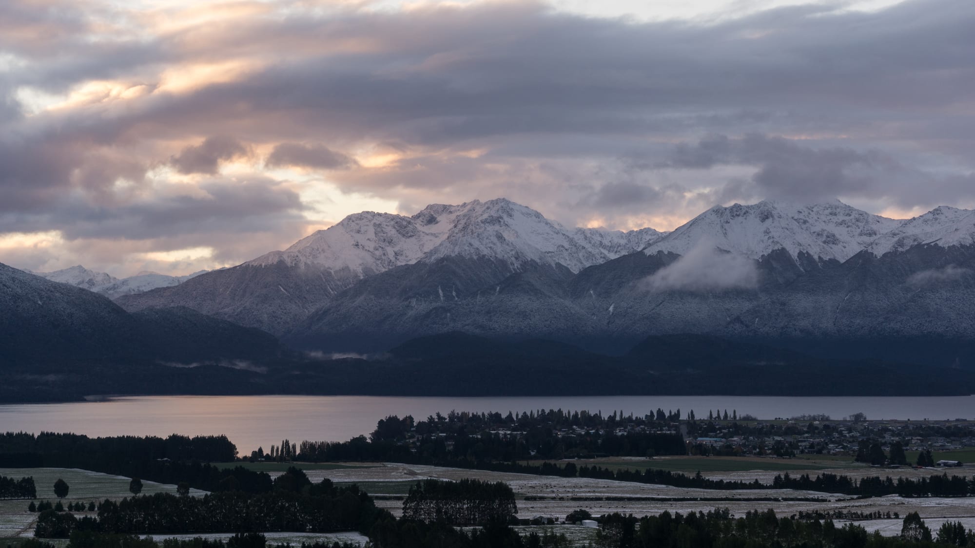
A low town strung along the far shore of a grey lake at dusk, with snow-dusted mountain ranges and heavy cloud behind it

Queenstown, Otago & Southland, New Zealand

Te Anau

Te Anau on the shore of its lake, with the Murchison Mountains behind after the first snow of the season. (Tim Burgess / Wikimedia Commons · CC BY-SA 4.0)

A small town on the eastern shore of Lake Te Anau in Southland, at the edge of Fiordland National Park. Farming country runs east from it and mountains and beech forest rise across the water, and it grew from a fishing and guiding settlement into the main base for Milford Sound, the Milford and Kepler tracks and the fiords beyond.

Neighbourhoods

  • The lakefront
    • First-time visitors
    • Best for food
    • Walks

    Lakefront Drive follows the shore for a kilometre or so past hotels, motels, cafés and tour offices, with a grassed reserve, a jetty and the boats for the glowworm caves and the cruises. The view across the water to the Kepler and Murchison ranges is the reason most rooms here cost more.

    Open in Maps
  • The town centre
    • Close to public transport
    • Practical stays

    A compact grid a block behind the lake around Town Centre and Milford Crescent, with the supermarket, the bakery, outdoor shops, the bus stop and the Department of Conservation visitor centre. Almost every service in Fiordland is in these few streets.

    Open in Maps
  • The eastern streets and the golf course
    • Quiet and residential
    • Camping

    Residential Te Anau spreads east towards the farmland, with holiday parks, cabins, self-contained houses and the golf course among the pine shelter belts. It is a flat walk or short cycle of ten to fifteen minutes into the centre and noticeably cheaper.

    Open in Maps
  • Te Anau Downs
    • Trampers
    • Quiet and residential

    A tiny lakeside stop about 30 kilometres north on the Milford road, where the boat leaves for the start of the Milford Track. There is a lodge, a campsite and little else, set against the mountains at the head of the lake.

    Open in Maps
  • Manapōuri
    • Quiet and residential
    • Boat trips

    A village on the shore of Lake Manapōuri about 20 kilometres south, with a handful of lodges and a boat launch. Trips to Doubtful Sound leave from here, and it is the quietest of the Fiordland bases.

    Open in Maps

Things to do

The lake and the caves

  • Lake Te Anauattraction

    The largest lake in the South Island, glacier-carved and as much as 425 metres deep, with three long arms — North, Middle and South Fiords, the only inland fiords in New Zealand — reaching west into the mountains.

    Open in Maps
  • Te Anau Glowworm Cavesattraction

    A limestone cave system on the far shore of the lake, reached by boat, where a small underground river and a grotto of glowworms are visited by walkway and punt.

    Open in Maps
  • Punanga Manu o Te Anauattraction

    The town's bird sanctuary on the southern shore of the lake, where takahē, kākā, Antipodes Island parakeets and whio, the blue duck, can be seen.

    Open in Maps

Walks and viewpoints

  • Kepler Tracktrail

    A Great Walk of about 60 kilometres that loops from near the town over a high ridge above the bush line, with huts and long views over the lake and Fiordland.

    Open in Maps
  • Lakeside Track to the control gatestrail

    An easy, flat walking and cycling path along the lake shore from the town to the gates where the Waiau River leaves the lake, the start of the Kepler Track.

    Open in Maps
  • Murchison Mountainsviewpoint

    The range across the lake where the takahē, thought extinct, was rediscovered in 1948; much of it is a restricted special area closed to casual visitors.

    Open in Maps

Fiordland and the Milford road

  • Fiordland National Parkpark

    The country's largest national park, part of the Te Wāhipounamu World Heritage Site, beginning at the edge of the town and running west to the coast.

    Open in Maps
  • Milford Tracktrail

    A Great Walk from the head of Lake Te Anau over McKinnon Pass to Milford Sound, walked in one direction on booked huts in the regulated season from late October to late April.

    Open in Maps
  • Mirror Lakesattraction

    Small still ponds in the Eglinton Valley on the Milford road, known for reflecting the Earl Mountains on a calm morning.

    Open in Maps
  • Lake Gunnpark

    A forest-ringed lake beside the Milford road, with a loop walk through old beech forest and a Department of Conservation campsite on the shore.

    Open in Maps

Short trips from the town

  • Milford Soundattraction

    The best-known fiord in New Zealand, with Mitre Peak and high waterfalls, reached by a drive of about two hours from the town through the Homer Tunnel.

    Open in Maps
  • Lake Manapōuriattraction

    A deep lake of wooded islands south of the town, the starting point for boat and coach trips over Wilmot Pass to Doubtful Sound.

    Open in Maps
  • Manapouri Power Stationattraction

    An underground hydro-electric station in the rock at West Arm, built in the 1960s and the focus of a national conservation campaign over the level of the lake.

    Open in Maps

Seasonal events

  • Great Walks seasonlate October to April

    The months when huts on the Milford and Kepler tracks are booked and serviced, and when the town is fullest with trampers.

  • Kepler ChallengeDecember

    A long-running mountain run over the Kepler Track, held early in the summer.

Eat and drink

Long-standing places and food districts in Te Anau. Hours, ratings and directions come from your maps app, always current.

Where to eat in Te Anau

  • The lakefront stripneighborhood

    Most of the town's kitchens face the water along Lakefront Drive — pub meals, pizza, Indian and Thai food and a couple of restaurants working with Southland lamb, venison and blue cod.

    Open in Maps
  • Town Centre bakeries and caféscafe

    The block behind the lake has the bakery, coffee and takeaway counters that feed trampers before the early buses to the tracks, and sells the pies and filled rolls that go into packs.

    Open in Maps
  • Fiordland cheese rollsrestaurant

    Southland's signature snack — a slice of bread spread with a cheese and onion mixture, rolled and toasted — appears on almost every café board in the town.

    Open in Maps

Self-catering

  • Te Anau supermarket and butchersmarket

    The last full supermarket before Milford Sound, and the place trampers buy several days of food; local butchers sell Southland lamb, beef and venison sausages.

    Open in Maps

Experience Te Anau

History

Kāi Tahu knew the lake and its arms as part of the network of trails that led west to the pounamu of the coast and to seasonal food-gathering grounds, and the name Te Ana-au — the cave of swirling water — refers to the limestone caves on the far shore, rediscovered by a local guide in the 1940s after being described in tradition. European surveyors reached the lake in the early 1850s, and runholders took up the grassland to the east soon afterwards.

Tourism arrived with the Milford Track. Quintin McKinnon and a companion crossed the pass at the head of the Clinton Valley in 1888, opening a walking route to Milford Sound, and guided parties were soon travelling by boat up the lake to begin it. A hotel, boatmen and guides made a small settlement at the lake's south-eastern corner, but until the road from Lumsden and Mossburn improved, Te Anau remained remote and seasonal.

Two projects made the modern town. The Milford road, begun in the Depression and completed when the Homer Tunnel opened in 1953, turned the fiord into a day trip and gave the town its reason for existing. Then the Manapouri hydro scheme of the 1960s brought hundreds of workers to the district, and the proposal to raise Lake Manapōuri drew a petition signed by 264,907 New Zealanders, almost a tenth of the population — the Save Manapouri campaign of 1969 to 1972, which succeeded and is remembered as one of the country's hardest-fought environmental campaigns. Te Anau has grown steadily since, on walking, cruising and flying into Fiordland.

Culture & Customs

The culture here is built around the national park on the doorstep. A large part of the working population guides, skippers, flies, cooks for or transports visitors into Fiordland, and another part works for the Department of Conservation on huts, tracks, traps and bird recovery. Conversation runs to weather windows, river levels, hut bookings and which road is open, and there is a shared, slightly proprietorial pride in the place.

Conservation is the local creed rather than an abstraction. The takahē, a large flightless rail believed extinct, was found again in the Murchison Mountains across the lake in 1948, and its recovery programme is run from near the town; the bird sanctuary on the lakefront introduces it to visitors. Predator trapping, whio recovery in the fiords and the memory of the Save Manapouri campaign all reinforce it. Biosecurity rules about cleaning boots and boats are followed closely.

Beyond that, this is Southland: farming families, a rugby club, an A&P show, hunting and fishing for deer, trout and salmon, and a dry humour about rain and sandflies. The seasonal workforce is international, so the cafés in summer sound like Queenstown in miniature, while winter returns the town to a few thousand residents, dark evenings and quiet streets. Visitors are expected to be competent outdoors and honest about their limits; guides are direct about turning parties back.

Daily Life

About 2,900 people live in Te Anau, which makes it the largest settlement in Fiordland and the service centre for a very large, nearly empty district. Numbers swell in summer with seasonal staff and visitors, and the town's accommodation, supermarket and health services are all sized for peaks rather than for the resident population.

Work divides between tourism, farming and conservation. Cruise companies, helicopter and light-aircraft operators, lodges, motels, holiday parks and transport firms employ most people; sheep, beef and dairy farms and deer farms run on the flats towards Mossburn and Manapōuri; the power station at West Arm and the Department of Conservation provide steady year-round jobs. The local school, health centre and trades round it out.

The rhythm is set by departures. Buses and vans leave for the Milford road, the Kepler trailhead and Te Anau Downs early in the morning, the town is calm in the middle of the day, and the lakefront fills again when the cruises and walkers return. Winter thins out the population, some businesses close for weeks, and households drive to Invercargill or Queenstown for larger shopping and hospital care. Local issues are the shortage of housing for seasonal workers, how many visitors the Milford road and the fiord itself can carry, and long-standing proposals for new transport links into the park.

Food

Eating in Te Anau is straightforward and portion-heavy, aimed at people who have spent the day outdoors. Southland lamb and beef, farmed red deer venison, and blue cod brought up from the southern coast anchor the restaurant menus, often alongside Fiordland crayfish and green-lipped mussels. Brown and rainbow trout from the lakes and the Waiau River are a local catch, usually eaten by those who catch them rather than bought.

The regional speciality is the cheese roll, bread spread with a cheese, onion and evaporated-milk mixture, rolled up and toasted, and known in the south as southern sushi. Bakeries sell mince, steak and cheese pies by the trayload, particularly early in the morning when trampers are assembling food for several days on a track. Dried and freeze-dried meals, muesli bars and chocolate fill a surprising amount of shelf space in the supermarket for the same reason.

Drinks come mostly from the wider south. Central Otago pinot noir and riesling appear on wine lists an hour or two from where they are made, Invercargill and Queenstown breweries supply craft beer, and Bluff oysters arrive in autumn and winter when the season in Foveaux Strait opens. Coffee is taken as seriously as anywhere in New Zealand, and a flask of tea remains standard equipment on the lake boats.

Planning tools

Budget

Te Anau is cheaper than Queenstown for beds and food and is the usual value base for Fiordland, though prices still rise through the summer. The costs that matter are the trips: a Milford or Doubtful Sound cruise, a scenic flight, the boats and buses at either end of the Great Walks, and hut fees. Walking the lakeside track, the bird sanctuary and the shorter Milford road stops cost nothing or very little.

Daily Budget Midrange
USD 160–300 (motel or lodge, restaurant meals, a hire car, a fiord cruise)
Daily Budget Shoestring
USD 55–95 (hostel bed or holiday park, supermarket food, bus transfers)

Book Great Walk huts as soon as bookings open for the season, and buy food here rather than on the Milford road, where there are no shops.

Best Time to Visit

November to April, when the Great Walks season runs, the huts are serviced and the Milford road is least likely to be closed. December to February is warmest and busiest, and March and April are quieter with settled weather and fewer sandflies. Winter is cold and very quiet, with snow on the tops, short days and avalanche closures possible on the road to Milford.

Suggested Number of Days

Two nights is the common length of stay, since the main fiord trip takes most of a day and the weather may force a change of plan. Four or five nights suit longer walks, a second fiord or a spell of rain, and a multi-day Great Walk needs its own week.

First Visit
2 days
With Surroundings
4–5 days

Transportation

The town is small and flat, and everything in it is walkable. Coaches and shuttles link it to Queenstown and Invercargill and run day trips to Milford Sound; track transport services take walkers to the Kepler trailhead, Te Anau Downs and the Routeburn. Most independent visitors drive, and a car is needed for the Milford road stops and for Manapōuri. Fuel is available in the town and at Milford but almost nowhere between.

Carry chains in winter for the Milford road, check its status before setting out, and allow far longer than the distance suggests, as the stops are the point of the drive.

Airport & Station Connections

Te Anau is about 170 kilometres from Queenstown, a drive of two to two and a half hours, and roughly 160 kilometres from Invercargill. Milford Sound lies about 120 kilometres north by the only road, which takes around two hours each way. Scheduled coaches connect the town with Queenstown, Invercargill and Dunedin; the nearest airports with airline flights are Queenstown and Invercargill, and a small local aerodrome handles scenic flights.

Walkability

One of the easiest towns in the country to manage without a car: the lakefront, the shops, the visitor centre and the bird sanctuary are all within about a kilometre, and the lakeside track continues for several kilometres in each direction on the flat. Footpaths give way to gravel verges at the edges of town, and the highway through it carries coaches and campervans.

Safety

The town is safe and crime is minor, mostly theft from vehicles at trailheads. The real hazards are in the national park: Fiordland's weather changes very fast, rivers rise within hours of heavy rain, tracks are exposed above the bush line, and avalanche paths cross the Milford road in winter and spring. Lake water is cold all year, and mobile coverage disappears a short way out of town.

Intentions should be left with someone or logged at the visitor centre, warm and waterproof clothing carried on any walk, river crossings avoided in flood, and a locator beacon hired for overnight trips. Check current official travel advice before travelling.

Climate

Cool, changeable and wet, on the dry side of Fiordland but far wetter than Central Otago. Rain can arrive at any time of year and is heaviest in the mountains to the west. Summer is December to February in the southern hemisphere, with very long evenings this far south.

Summer
mild rather than hot, with days usually 17–22°C, cool nights and frequent showers
Winter
cold, with days around 5–9°C, hard frosts, snow on the surrounding ranges and occasional snow in the town

Local Customs

This is a working Southland town whose business happens to be the national park: early starts, boots and raincoats in every doorway, and conversation about the weather forecast and track conditions. The Southland accent, with its rolled 'r', is noticeable. Kāi Tahu hold the lakes and the pounamu trails in their history, and the name Te Ana-au, the cave of swirling water, refers to the caves across the lake. Biosecurity matters here: boots and gear are cleaned to keep didymo out of the waterways.

Tipping is not expected. Sandflies are relentless near the water, so repellent is part of local etiquette; take all rubbish out of the park, keep to formed tracks, and never feed keas, which will damage cars and packs.

Common Payment Methods

The currency is the New Zealand dollar. Cards and contactless payment are taken in the town's shops, cafés and tour offices, and there are ATMs in the centre. Some hut fees, campsites and small operators prefer cash or advance online payment, and there are no banking services on the Milford road, so it is worth arranging money before leaving town.