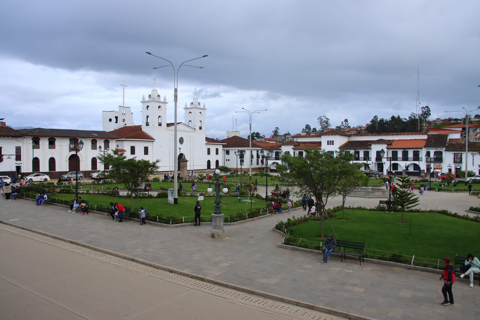
A green plaza with lawns and lamp posts, a white twin-towered church and white colonial houses with tiled roofs under a grey sky

Chachapoyas, Iquitos & the Northern Amazon, Peru

Chachapoyas

The Plaza de Armas of Chachapoyas, with its whitewashed colonial houses. (Draceane / Wikimedia Commons · CC BY-SA 4.0)

The small capital of Peru's Amazonas region, set at about 2,300 metres in the cloud-forested mountains of the north-east. Founded by the Spanish in 1538 in the land of the Chachapoya people, it is known for the large houses with inner courtyards of its historic centre, and today it is the quiet base for the fortress of Kuélap, the Gocta falls and the cliff tombs of the Utcubamba valley.

Neighbourhoods

  • Plaza de Armas and the historic centre
    • First-time visitors
    • Historic district

    A grid of whitewashed colonial houses with tiled roofs, wooden balconies and large inner courtyards around a square about 100 metres on each side. The cathedral, the bishop's house, most hotels and the tour agencies that run trips to the ruins and waterfalls are all within a couple of blocks.

    Open in Maps
  • Luya Urco
    • Quiet and residential
    • Local legends

    One of the old barrios, on the hill on the western side of town. It holds the Pozo de Yanayacu, the spring that legend says the saint Toribio de Mogrovejo brought out of a rock to end a drought.

    Open in Maps
  • Santo Domingo and Plaza Independencia
    • Historic district
    • Local life

    The eastern side of the centre, around the square that commemorates the town's heroes of the battle of Higos Urco in 1821. Nearby Plaza Santa Ana is said to be the town's first square and the site of its first church.

    Open in Maps

Things to do

In town

  • Chachapoyas Cathedrallandmark

    The cathedral of St John the Baptist on the main square, rebuilt after the 1928 earthquake and restored to its earlier style in 2010.

    Open in Maps
  • Pozo de Yanayacuattraction

    A spring on Luya Urco hill tied to a legend of Toribio de Mogrovejo; it is said that a stranger who drinks from it will stay in Chachapoyas for ever.

    Open in Maps
  • Plaza Independencialandmark

    The square on the east side of town with a monument to the local fighters of the battle of Higos Urco, fought on 6 June 1821.

    Open in Maps

Close to town

  • Huancasattraction

    A village just north of the town, known for pottery made by its women, with a natural viewpoint over the Sonche river canyon.

    Open in Maps
  • Sarcophagi of Karajíalandmark

    Large pre-Inca Chachapoya sarcophagi, up to 2.5 metres tall, standing in a row on a cliff ledge north-west of the town, left almost intact by their hard-to-reach position.

    Open in Maps

Short trips from the town

  • Kuélaplandmark

    The walled Chachapoya settlement on a limestone ridge at about 3,000 metres, with ramparts 10 to 20 metres high around more than 400 mostly round buildings; part of its perimeter wall collapsed in April 2022, and the Ministry of Culture launched emergency conservation measures.

    Open in Maps
  • Gocta Cataractspark

    A two-tiered waterfall in Bongará province, made known to the outside world after an expedition in 2002 and reached on foot through cloud forest from Cocachimba or San Pablo.

    Open in Maps
  • Gran Vilayatrail

    A wide area of Chachapoya ruins west of Kuélap, crossed by multi-day treks on foot and horseback that end at the fortress.

    Open in Maps
  • Levantoattraction

    An early site of the Spanish town, with a stretch of old Inca road and the ruins of Yalape in the district.

    Open in Maps
  • Revashlandmark

    A funerary complex of small house-like tombs built into a limestone cliff at about 2,800 metres, south of the town.

    Open in Maps
  • Leymebambaattraction

    A village in the upper Utcubamba valley whose museum holds many of the mummies found at the Laguna de los Cóndores, where more than 200 mummy bundles were discovered.

    Open in Maps

Seasonal events

  • CarnivalFebruary or March, before Lent

    The town's carnival includes the humisha, a decorated tree that dancers bring down; whoever fells it must raise and decorate the next year's.

  • Semana Turísticafirst week of June

    Tourist Week, with a large Sunday parade of villages from all the provinces of Amazonas in traditional dress.

  • Danza del Levantolate June

    A traditional dance whose performers wear dark grey ponchos and rattles of dried seed pods on their ankles.

  • Virgen Asuntafirst half of August

    The festival of the town's patron, whose image is kept in its own sanctuary until the celebrations begin.

Eat and drink

Long-standing places and food districts in Chachapoyas. Hours, ratings and directions come from your maps app, always current.

Food districts and markets

  • Mercado Centralmarket

    The town's central market, a few blocks from the main square, selling produce from the surrounding valleys alongside simple food stalls.

    Open in Maps
  • Restaurants around the Plaza de Armasneighborhood

    The blocks around the main square hold most of the town's restaurants, from set-menu lunch places to cafés catering to travellers back from the ruins.

    Open in Maps

Experience Chachapoyas

History

Chachapoyas takes its name from the Chachapoya, the "Warriors of the Clouds", who lived in the cloud forests of what is now the Amazonas region and were conquered by the Inca shortly before the Spanish arrived. Their settlements, burial cliffs and the fortress of Kuélap, built on a ridge above the Utcubamba, surround the town on every side. Because the Inca and the conquistadors were the main early sources on them, much about the Chachapoya remains uncertain.

The Spanish town was founded on 5 September 1538 by the conquistador Alonso de Alvarado as San Juan de la Frontera de los Chachapoyas. It was first set up near La Jalca and then near Levanto, but these sites were abandoned because of the climate, disease and attacks by local groups, and the town is believed to have moved to its present location in about 1545. It grew into a provincial centre of large colonial houses, and was the birthplace of Toribio Rodríguez de Mendoza, an academic counted among the forerunners of Peruvian independence. On 6 June 1821 local fighters won the battle of Higos Urco, remembered in the Plaza Independencia.

The diocese based in the town took the name of Chachapoyas in 1843, and the town is the capital of the Amazonas region. An earthquake in 1928 almost completely destroyed the town, and the cathedral had to be rebuilt. For most of its history the town was cut off from the rest of the country by its mountains; only recently have better roads linked it with the northern coast, and a cable car to Kuélap, finished in 2017, has made the fortress much easier to reach.

Culture & Customs

The town's own dance is the chumaichada, which no local festival can end without. Its music is probably of Indigenous origin, while its figures come from Los Lanceros, a French dance introduced by Emilio Lissón, a bishop of the diocese. Villages nearby keep other dances, among them the Danza del Levanto, performed in dark grey ponchos with dried seed pods rattling at the ankles. At carnival dancers bring down the humisha, a tree hung with gifts, and whoever fells it must put up a better one the following year.

Religious life follows the Catholic calendar. The Virgen Asunta is the town's patron, and her festival fills the first half of August; in neighbouring Huancas the patron is the Señor de los Milagros, kept there as a statue rather than as a painting as in Lima. Huancas is also known for its pottery, traditionally made by women while the men work the fields.

Local legends are part of the town's identity. The Pozo de Yanayacu, on Luya Urco hill, is said to have been opened by Toribio de Mogrovejo to end a drought, and whoever drinks its water is said to stay for ever. Football is the most popular sport, and Tourist Week in June brings villages from across Amazonas into town in traditional dress.

Daily Life

The town had about 32,000 people at the 2017 census, and its population was estimated at around 36,000 by 2023. As regional capital it lives largely from government offices, schools, the diocese and the Universidad Nacional Toribio Rodríguez de Mendoza, as well as trade with the surrounding farming districts, which grow sugar cane, coffee, cassava, cereals and orchids. Tourism, centred on Kuélap and Gocta, has grown into an important source of work for agencies, drivers, guides and guesthouses.

The oldest barrios — La Laguna, Yance, Santo Domingo, Luya Urco and Higos Urco — form the historic core, while newer housing estates have spread around them. The former lagoon in the centre, once ringed with reeds and palms used to build the early churches, is now the site of the Kuélap stadium.

Life is unhurried. Mornings start early, with vans leaving for the villages before dawn and the market busy by first light; the main square fills with families and students in the evening. The town remains far from Peru's big cities, and long, slow roads shape its economy and the cost of everything brought in.

Food

Chachapoyas sits between the Andes and the Amazon, and its food draws on both. The valleys around it grow cereals, cassava, sugar cane and coffee, and trout from mountain streams appears on menus in the villages of the Utcubamba valley. Highland staples found across Peru — hearty soups, roast cuy (guinea pig) and dishes of potato and maize — are everyday fare.

Most eating is simple and local. Set lunches, the menú, of soup and a main course are the everyday meal, served in small restaurants around the main square and near the central market, where farmers bring in produce from the surrounding valleys. Coffee and sugar cane are among the crops of the district around the town.

The town's cafés serve visitors returning from Kuélap and Gocta, and the restaurants in Cocachimba and Tingo feed walkers on the way to the falls and the fortress. María, a village on the road to Kuélap where visitors can stay overnight, has several small restaurants known for trout.

Planning tools

Budget

Chachapoyas is an inexpensive town. Rooms, set lunches and local minibuses cost little; the main expenses are the agency day tours to Kuélap, Gocta and the tombs, the Kuélap cable car and entry fees, and getting there, since flights are few and the buses are long.

Daily Budget Midrange
USD 70–150 (mid-range hotel in a colonial house, agency day tours, restaurant dinners)
Daily Budget Shoestring
USD 25–45 (hostel or guesthouse, set lunches, minibuses to the villages)

Agencies on the main square sell similar tours at similar prices, but guides vary — meeting the guide first and checking the language spoken is worthwhile.

Best Time to Visit

The drier months, roughly May to September, are best for Kuélap, Gocta and the trails, when paths are firmer and views clearer. The rest of the year brings more rain and mist, and muddy walks, though the waterfalls run full. June has Tourist Week and August the patron festival.

Suggested Number of Days

Two or three days cover the town and the two main excursions. Four to six allow for the cliff tombs, the southern valley and a night in a village, and longer treks need more. Long road journeys in and out add time at both ends.

First Visit
2–3 days
With Surroundings
4–6 days

Transportation

The centre is walked. Agency vans run the day tours, and shared vans and taxis leave from stations a few blocks from the main square for Kuélap's cable-car station, Leymebamba, Luya and other villages. Mountain roads are slow and winding, so even short distances take time.

Ask agencies or the van stations about departure times the day before; early starts are normal for the villages and the southern valley.

Airport & Station Connections

Chachapoyas Airport, on a mesa just north of the town, has a small number of flights from Lima. More travellers fly to Jaén, about four hours away by road, or to Tarapoto, about eight hours to the east, or come by overnight bus from Chiclayo on the coast; direct buses from Lima take about 22 hours. A long, spectacular road also runs south via Leymebamba and Celendín to Cajamarca.

Walkability

The compact grid of the centre is easy to walk, with most hotels, restaurants and agencies within a few blocks of the Plaza de Armas. The town sits at about 2,300 metres and some streets climb steeply, so visitors arriving from the coast may tire quickly at first.

Safety

Cajamarca, Chachapoyas, Tarapoto and Iquitos are generally calm, with petty theft the usual risk. The real hazards are on the roads and trails: narrow mountain roads, steep and slippery paths to Gocta and the tombs in the rainy season, and the altitude of Kuélap.

Wear proper footwear for the walks, carry rain gear, and use established agencies and bus companies. Check current official travel advice before travelling.

Climate

A mild, humid highland climate on the edge of the Amazon. The average maximum is about 20°C and the average minimum about 9°C, and nights can fall close to freezing in exposed places. Rainfall is moderate compared with the jungle further east, and mist often covers the hills in the rainy season.

Summer
the rainy season, roughly October to April, brings frequent rain, mist and muddy trails, with mild days around 20°C
Winter
the drier months, about May to September, bring more sun by day, with daytime highs near 20°C and cool nights around 9°C

Local Customs

Chachapoyas is a conservative, Catholic provincial town with a strong sense of its own history and its Chachapoya heritage. Dress modestly in churches, greet shopkeepers and guides before asking for anything, and treat the tombs and burial sites as the graves they are.

Do not touch or climb on ruins, sarcophagi or remains, and ask before photographing people, especially in the villages.

Common Payment Methods

The currency is the Peruvian sol. Cards are accepted in some hotels and agencies, but cash is used for most meals, minibuses, village entry fees, horse hire and small purchases, so it is best to arrive with enough soles before heading out to the villages and sites.