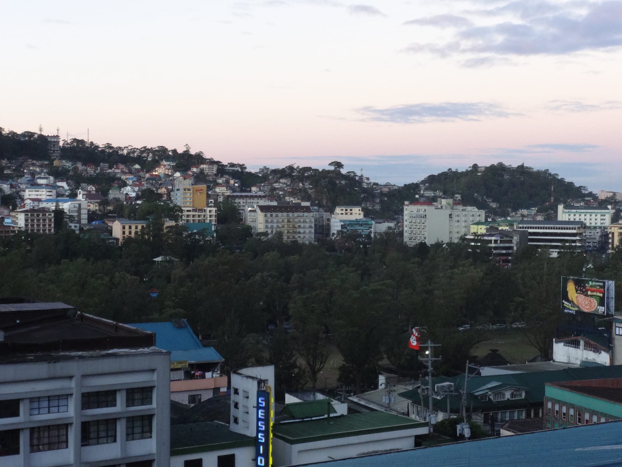
Closely packed houses and low buildings climbing pine-covered ridges above a wooded park, under a pale dusk sky

Northern Luzon, Philippines

Baguio

Baguio's ridges and rooftops above the trees of Burnham Park at dusk. (patrickroque01 / Wikimedia Commons · CC BY-SA 4.0)

The main city of the Cordillera highlands, laid out by American planners from 1904 at about 1,500 metres as a summer capital away from the lowland heat. Pine ridges, a cool damp climate, universities, markets and a long-established artistic scene define it, and Filipino visitors fill it at every holiday.

Neighbourhoods

  • Central Business District and Session Road
    • First-time visitors
    • Shopping
    • Close to public transport

    The commercial core on the ridge, built around Session Road's slope of shops, bakeries, cinemas and restaurants, with the cathedral above it and the public market below. Most hotels, jeepney terminals and taxis are here, and so is most of the traffic.

    Open in Maps
  • Burnham Park and Harrison Road
    • Parks
    • Families
    • Markets

    The flat ground at the bottom of the city, where the planned park holds a boating lake, gardens and skating rink, and Harrison Road's night market spreads out along the pavement after dark. Guesthouses and budget hotels ring the park.

    Open in Maps
  • Camp John Hay
    • Quiet and residential
    • Walks
    • Golf

    The former American rest and recreation base on the southern ridges, now a development of hotels, pine trails, a golf course and cafés. It is wooded, cool and considerably quieter than the centre, but a ride from the shops.

    Open in Maps
  • Mines View and Gibraltar
    • Viewpoints
    • Souvenirs

    The north-eastern ridge, where a viewing deck looks over old mining country towards the Benguet mountains and stalls sell woven goods, strawberries and knitwear. The road up is lined with lodges and small hotels.

    Open in Maps
  • Quezon Hill and the northern ridges
    • Local life
    • Arts and crafts

    Dense residential slopes above the market, with houses stacked on hairpin roads and the city's clearest sense of how most Baguio residents actually live. An artists' village of reassembled Cordillera houses sits on the edge of this side of town.

    Open in Maps

Things to do

Parks and viewpoints

  • Burnham Parkpark

    The city's central park, named after the American planner Daniel Burnham, with a man-made boating lake, lawns, gardens and rented bicycles.

    Open in Maps
  • Mines View Parkviewpoint

    A viewing platform on the north-eastern edge of the city looking down into the old Benguet mining valley, backed by a lane of souvenir stalls.

    Open in Maps
  • Wright Parkpark

    A long reflecting pool lined with pines opposite the presidential summer residence, with a riding area where ponies are hired at the bottom of the steps.

    Open in Maps
  • Baguio Botanical Gardenpark

    Terraced gardens on the way to Mines View, with Cordillera house replicas, sculpture and shaded paths.

    Open in Maps
  • Camp John Haypark

    The wooded former American base, with pine trails, a golf course, an eco-trail and the Bell House amphitheatre among the trees.

    Open in Maps

Landmarks

  • Baguio Cathedrallandmark

    The rose-pink twin-towered cathedral of Our Lady of Atonement, reached by a long flight of steps from Session Road, which sheltered civilians during the bombing of 1945.

    Open in Maps
  • Session Roadlandmark

    The sloping main street of the business district, lined with bakeries, restaurants, shops and old cinemas, and closed to traffic for street fairs during festivals.

    Open in Maps
  • The Mansionlandmark

    The official summer residence of the president of the Philippines, built in 1908, seen through an ornamental gate opposite Wright Park.

    Open in Maps
  • Philippine Military Academylandmark

    The country's officer academy at Fort del Pilar on the southern edge of the city, whose grounds, parade ceremonies and small museum are open to visitors.

    Open in Maps
  • Lourdes Grottolandmark

    A hillside shrine west of the centre reached by a long staircase, busy with pilgrims during Holy Week.

    Open in Maps

Museums, crafts and markets

  • BenCab Museummuseum

    The museum of the painter Benedicto Cabrera on the Asin road south-west of the city, showing his work, Cordillera carvings and contemporary Philippine art above a garden and pond.

    Open in Maps
  • Tam-awan Villageattraction

    A cluster of relocated Ifugao and Kalinga houses on a hillside in the north of the city, run as an artists' village with workshops, galleries and a café.

    Open in Maps
  • Baguio City Public Marketmarket

    A large covered market below Session Road selling highland vegetables, strawberries, coffee, woven cloth, brooms and preserves.

    Open in Maps
  • Harrison Road night marketmarket

    An evening street market of second-hand clothes, knitwear and street food that takes over the road beside Burnham Park after dark.

    Open in Maps

Short trips from the city

  • La Trinidadneighborhood

    The Benguet capital immediately north, a vegetable-trading valley known for its strawberry farms and a painted hillside of coloured houses.

    Open in Maps
  • Mount Pulagtrail

    The highest peak in Luzon, east of the city in Benguet, climbed overnight for sunrise above a sea of clouds and requiring permits and guides.

    Open in Maps

Seasonal events

  • Panagbenga Flower FestivalFebruary, into early March

    The city's best-known festival, a month of street dancing, marching bands and a parade of flower-covered floats, ending with a street fair along Session Road.

  • Ibagiw Creative Festivalannually

    A festival of crafts, weaving, tattooing, art and design, tied to the city's place in the UNESCO Creative Cities Network for crafts and folk art.

  • Holy WeekMarch or April

    Pilgrims climb to the Lourdes Grotto and the city fills with lowland visitors escaping the hottest weeks of the year.

  • Christmas and New Yearlate December to early January

    The coldest and busiest stretch of the year, with lights through the parks, heavy traffic on the mountain roads and hotels booked out.

Eat and drink

Long-standing places and food districts in Baguio. Hours, ratings and directions come from your maps app, always current.

Baguio classics

  • Strawberry tahomarket

    Warm soft tofu with tapioca pearls and strawberry syrup instead of the usual caramel, sold by vendors around the parks and viewpoints.

    Open in Maps
  • Ube jam and highland preservesmarket

    Purple yam jam, strawberry preserves and peanut brittle are the standard things carried home, made by convents, cooperatives and market stalls.

    Open in Maps
  • Pinikpikan and etagrestaurant

    Cordillera cooking served in a handful of city eateries: chicken soup flavoured with etag, pork salted and smoked for months, alongside highland rice.

    Open in Maps
  • Baguio coffeecafe

    Arabica from Benguet and Sagada is roasted and served across the city, which has a dense café culture built around students and artists.

    Open in Maps

Markets and food streets

  • Baguio City Public Marketmarket

    Sections for vegetables, strawberries, sausages, coffee, dried goods and cheap cooked-food stalls, and the city's main food landmark.

    Open in Maps
  • Harrison Road night marketmarket

    Grilled skewers, fishballs, noodles and sweets among the clothing stalls that fill the road beside Burnham Park in the evening.

    Open in Maps
  • Session Roadneighborhood

    The main street's bakeries, long-running restaurants and cafés, from Filipino rice meals to Chinese noodle houses.

    Open in Maps

Experience Baguio

History

The plateau was Ibaloi land, grazed and gold-panned long before the city existed, and the small settlement of Kafagway lay where the central park now stands. Spain established a comandancia in the area in the 19th century but never developed it. The Americans did. Looking for a cool station away from lowland heat and disease, they identified the site around 1900, pushed Kennon Road up the gorge at heavy cost in workers' lives, and in 1904 commissioned Daniel Burnham to plan a hill town of parks, civic axes and low buildings on the ridges. Baguio was chartered in 1909 and served as the summer capital of the Philippines, with a presidential residence, a rest camp for the American military and schools that drew families from across the archipelago.

The land deals that created the city dispossessed Ibaloi families, a grievance that has never entirely faded and still surfaces in land cases. In 1945 Baguio was destroyed almost completely: it was bombed heavily during the campaign against Japanese forces holding the Cordillera, and the Japanese surrender in the Philippines was formally signed in the city that September.

Rebuilt through the 1950s, Baguio grew far beyond the plan — universities, a mining and vegetable trade, an export-processing zone and waves of migration from the lowlands and the mountains filled the ridges with houses. The July 1990 Luzon earthquake struck it severely, collapsing hotels and cutting the roads for weeks. Recovery was rapid, and the problem since has been growth itself: traffic, water supply, tree cover and the survival of the original plan are permanent subjects of argument.

Culture & Customs

Baguio is the meeting place of the Cordillera. Ibaloi and Kankanaey families are the original highland population of the area, joined over a century by Ifugao, Kalinga, Bontoc, Ilocano and lowland migrants, and the result is a city where several languages are heard on one jeepney and Ilocano, Filipino and English do the work of a common tongue. The city holds Cordillera cultural institutions, and highland weaving, carving and gong music are as present here as in the villages, though in an urban setting.

It is also an arts city, unusually so for its size, with a long line of painters, sculptors, writers and musicians drawn by the climate and the cheap rents; galleries, artists' villages and craft workshops are spread across the ridges, and Baguio belongs to the UNESCO Creative Cities Network for crafts and folk art. The student population of its universities keeps cafés, bookshops and small music venues busy through the academic year.

The big public occasion is Panagbenga, the flower festival created in the 1990s partly to lift spirits after the earthquake, which fills February with float parades and street dancing and ends with Session Road given over to a fair. Manners are relaxed and slightly less formal than in the lowlands; the cold is a point of local pride; and residents have a well-known ambivalence about the holiday crowds that both sustain the city and clog it.

Daily Life

About 368,000 people live within the city limits, with many more in the surrounding Benguet towns that function as suburbs, and the population swells at every long weekend. Education is a pillar of the economy — several universities draw students from across the north — alongside government offices, tourism, a long-established electronics export zone at Loakan, and the vegetable and strawberry trade of the La Trinidad valley just over the ridge.

Housing has climbed every available slope. Whole neighbourhoods are stacked on hairpin roads where houses are entered from the roof of the one below, and the city's density, water supply and dwindling pine cover are constant political issues. Traffic in the central business district is severe, and jeepney routes radiating from the market are the daily reality for most residents.

The rhythm is set by the weather and the school calendar. Mornings are clear and cold, afternoons often cloud over and rain, and by evening the mist is in the pines. Students fill the centre on weekdays, lowland visitors on weekends, and the market and the night market beside Burnham Park are where the city mixes. Many families keep links to Benguet villages and return for planting, harvest and rituals.

Food

Baguio's food is the highlands brought to town. Vegetables grown in the Benguet terraces — cabbage, carrots, broccoli, lettuce — arrive daily at the public market, and the strawberries of La Trinidad turn up in jam, wine, ice cream and the taho sold by vendors at the viewpoints, where the usual caramel syrup is replaced by strawberry. Ube, the purple yam, is made into a thick jam that is the city's signature souvenir, sold alongside peanut brittle and lengua de gato biscuits.

Cordillera cooking is served in a small number of restaurants: pinikpikan, a chicken soup flavoured with etag, the salted and smoked pork that gives highland dishes their particular depth, and heirloom red and black rice from the mountain terraces. Ilocano staples are everywhere too — pinakbet, bagnet, longganisa and vinegar-heavy dipping sauces — reflecting the lowland origins of much of the population.

Coffee matters here. Arabica from Benguet and Sagada is roasted in the city and poured in cafés that double as student and artist hangouts, a scene that has grown steadily since the 1990s. In the evening the night market on Harrison Road adds grilled skewers, fishballs and noodle stalls, and the Chinese restaurants of the business district supply noodles and hot soup, which is what the climate asks for most of the year.

Planning tools

Budget

Baguio is moderately priced for the Philippines: rooms cost more than in surrounding provincial towns, especially at weekends, during Panagbenga and over Christmas, while food is cheap and the parks, viewpoints and pine trails cost nothing. Transport within the city is inexpensive, and the main extras are taxis to the outlying ridges and day trips into Benguet.

Daily Budget Midrange
USD 60–130 (hotel, restaurant meals, taxis, museum entries and a day trip into Benguet)
Daily Budget Shoestring
USD 25–45 (guesthouse or transient room, market and stall food, jeepneys)

Book months ahead for February, Holy Week and Christmas, when rooms and mountain roads both fill, and bring a jacket whatever the season.

Best Time to Visit

November to May is the drier half of the year, with December to February the coolest and clearest and February taken up by the flower festival. March to May is the traditional escape from lowland heat and therefore crowded. June to September brings the southwest monsoon, which is exceptionally wet here, with landslide risk on the access roads, and the typhoon season runs roughly from June to November.

Suggested Number of Days

Two or three days cover the city comfortably, allowing for slow traffic between ridges. Four to six suit a wider highland trip taking in Benguet and the mountain towns further north. Weekends are the busiest and slowest time to move around.

First Visit
2–3 days
With Surroundings
4–6 days

Transportation

Jeepneys are the backbone of city transport, running fixed routes from terminals around the market and the business district to every ridge, and taxis are plentiful, metered and cheap by national standards. The city is steep and traffic in the centre is heavy, so short distances can take a long time. Buses to the surrounding provinces leave from terminals near the park.

Baguio's one-way system and hills make walking between districts slow; taxis charge little for the climbs, and drivers here generally do use the meter.

Airport & Station Connections

Most people arrive by bus from Manila, four to six hours away by expressway and then Marcos Highway; overnight and hourly daytime services run from several Manila terminals. Kennon Road, the steep original approach, is closed at times in bad weather, while Naguilian Road leads down to the La Union coast. The Halsema Highway runs north to Sagada and the mountain towns, and Loakan Airport has had no regular commercial service since 2024.

Walkability

The central business district is walkable if the gradients are accepted: Session Road, the cathedral, the market and Burnham Park are within a kilometre or so of each other, though steps and steep pavements are constant. Outlying districts such as Camp John Hay, Mines View and the northern ridges are too far and too hilly to walk between comfortably, and traffic fumes in the centre are noticeable at peak hours.

Safety

Baguio is one of the safer Philippine cities, with the usual risk of pickpocketing in crowded markets, festivals and jeepney terminals. The more serious hazards are natural and structural: heavy monsoon rain brings landslides on the surrounding slopes and access roads, and the city sits in an active earthquake zone — the 1990 Luzon earthquake killed many people here.

Monitor PAGASA for storms, keep away from volcanic danger zones, take dengue precautions year-round, and do not travel to the Sulu provinces or the Zamboanga peninsula. Check current official travel advice before travelling.

Climate

A subtropical highland climate that sets Baguio apart from the rest of the country: cool, cloudy and damp, with mist rolling through the pines and a rainy season of remarkable intensity. Daytime temperatures rarely pass the mid-twenties Celsius, and nights are cold enough for blankets year-round.

Summer
mild and extremely wet, generally 18–26°C, with the heaviest rain of any Philippine city from June to September
Winter
cool and mostly dry, about 14–24°C by day, with December to February nights that can approach 10°C

Local Customs

The city is a meeting point of Cordillera peoples — Ibaloi, Kankanaey and others — alongside Ilocano and lowland settlers, and Indigenous identity is taken seriously: carvings, textiles and rituals are cultural property, not props. It is also a university city, informal in dress and manner, and warm clothing is normal in a way it is nowhere else in the country.

Ask before photographing market vendors or people in traditional dress, do not haggle aggressively over handwoven goods, and carry a jacket and umbrella year-round.

Common Payment Methods

The currency is the Philippine peso. Cards work in hotels, malls, larger restaurants and supermarkets, and cash machines are easy to find in the business district. Market stalls, jeepneys, taxis, the night market and small eateries are cash only, so small notes are worth carrying.