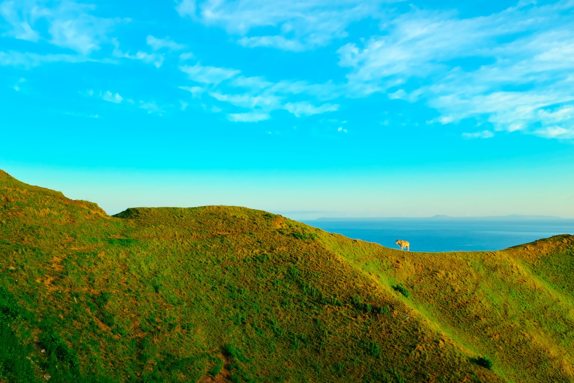
Rounded green grassy hills falling to a blue sea, with a single cow on the ridge and a faint island on the horizon

Northern Luzon, Philippines

Basco

Grazed hills above the sea at Vayang, on the western edge of Basco. (Johnkevinreglos / Wikimedia Commons · CC BY-SA 4.0)

The capital of Batanes, the Philippines' northernmost province, on Batan Island below the volcano Mount Iraya and closer to Taiwan than to most of Luzon. A small Ivatan town of stone houses, pastures running to sea cliffs and a lighthouse on a green headland, it is reached by flights that the weather regularly cancels.

Neighbourhoods

  • The town centre
    • First-time visitors
    • Close to transport

    A few flat blocks around the cathedral, the municipal hall, the market and the airport runway, which sits at the edge of town. Almost all the lodges, homestays and eateries are here, and everything can be reached on foot.

    Open in Maps
  • Naidi Hills
    • Viewpoints
    • Sunsets

    The grassy headland just north-west of the centre, topped by a stone lighthouse, a little over a kilometre on foot from the port. Paths run along the cliff edge, and the hill is the usual place to watch the sun go down over the sea.

    Open in Maps
  • Vayang and the western pastures
    • Walks
    • Quiet and residential

    Open grazing land on the ridges west of town where cattle and goats are kept and the ground drops to the water. Houses are scattered and the road is quiet, with the northern islands visible on clear days.

    Open in Maps
  • Tukon and the upper slopes
    • Views
    • Architecture

    The higher ground towards Mount Iraya, with a chapel in Ivatan-inspired style, the hilltop site of an old weather station and the road up through fields. Cooler and more exposed than the town, with long views over Batan.

    Open in Maps

Things to do

Around the town

  • Basco Lighthouselandmark

    A six-storey lighthouse on Naidi Hills, completed in 2003 on the site of the town's first lighthouse, with a viewing deck on the fifth floor looking over Batan Island and the sea.

    Open in Maps
  • Basco Cathedrallandmark

    The Cathedral of the Immaculate Conception, known as the Santo Domingo de Guzmán church, seat of the prelature of Batanes, established by Dominican missionaries in 1783 and rebuilt in stone from the 1790s after fires and typhoons.

    Open in Maps
  • Tukon Chapellandmark

    Our Lady of Mount Carmel Chapel at Chanarian, on the hill above the town: a modern chapel of stone designed with Ivatan-inspired architecture, looking over rolling ground and the sea.

    Open in Maps
  • Vayang Rolling Hillsviewpoint

    Grazed hills west of the centre where the grassland ends in sea cliffs, with Mount Iraya behind and the northern islands visible in clear weather.

    Open in Maps
  • Valugan Boulder Beachbeach

    A shore of smooth volcanic boulders on the exposed eastern side of Batan, facing the Pacific, rolled smooth by the surf.

    Open in Maps
  • Mount Irayatrail

    The forested stratovolcano of 1,009 metres that rises behind the town, the highest point in Batanes, climbed as a long guided day walk; it last erupted in 1454 and is still counted among the country's active volcanoes.

    Open in Maps

Short trips from the town

  • Mahataoneighborhood

    The next town south along the coast, with a stone church and high pastures where cattle graze above the sea.

    Open in Maps
  • Ivananeighborhood

    A small coastal town south of Basco with a fortress-like church, old Ivatan stone houses, and an unattended roadside shop of the kind where customers weigh their purchases and leave the money.

    Open in Maps
  • Sabtangneighborhood

    The island across the strait from Ivana, reached by open boat in calm weather, whose stone-house villages at Chavayan and Savidug are what the island is known for.

    Open in Maps
  • Uyuganneighborhood

    The southern town of Batan Island, with terraced fields, roofless stone-house ruins and a coastal road cut into the cliffs.

    Open in Maps

Seasonal events

  • Founding anniversary of Bascolate June

    The establishment of the town on 26 June 1783 is marked with civic, sporting and cultural programmes.

  • Kapayvanuvanuamid-March

    The opening of the flying-fish season, marked at the launching places at the start of the main fishing months.

  • Town fiesta of Santo Domingo de GuzmánAugust

    Basco's patronal feast, with mass at the cathedral, processions and community meals, held in the middle of the typhoon season.

  • Holy WeekMarch or April

    Processions and services in a deeply Catholic province, falling in the calmest weeks for sea and air travel.

  • Christmas and New Yearlate December to early January

    Families return from Manila and abroad, filling flights and lodges, and the town keeps a long round of church services and gatherings.

Eat and drink

Long-standing places and food districts in Basco. Hours, ratings and directions come from your maps app, always current.

Ivatan classics

  • Uvud ballsrestaurant

    Balls of minced banana corm mixed with meat or fish, fried or simmered in broth — the dish most associated with Ivatan cooking.

    Open in Maps
  • Coconut crab and seafoodrestaurant

    Flying fish, dorado and lobster come from the surrounding waters in season; coconut crab appears on some menus, though it is increasingly protected and scarce.

    Open in Maps
  • Luñis and root cropsrestaurant

    Pork preserved in its own fat and salt, eaten with turmeric rice, yams, sweet potato and garlic — island food built to keep without refrigeration.

    Open in Maps

Markets and food streets

  • Basco public marketmarket

    A small market for fish, root crops, vegetables and supplies brought in by plane or cargo boat, where stock depends on the weather.

    Open in Maps
  • Town-centre eateriesneighborhood

    A handful of family-run restaurants and lodge kitchens around the centre serve Ivatan dishes alongside standard Filipino rice meals.

    Open in Maps

Experience Basco

History

The Batanes islands were settled by Austronesian voyagers whose descendants, the Ivatan, built fortified hilltop settlements called idjang on defensible outcrops, fished the rough channels in open boats and farmed root crops on terraces. Their language and their seafaring link them closely to the peoples of Taiwan to the north, and the islands sat on trading routes long before Europeans reached them.

Spain claimed Batanes as part of the Philippines in 1783, under the governor-general José Basco y Vargas, after earlier contact and a visit by the English explorer and privateer William Dampier, who named the islands in 1687. The town established that June took the governor-general's name, and Dominican missionaries followed, building churches of lime and stone. Spanish rule brought resettlement from the hilltop idjang to coastal towns, a tobacco monopoly, and the lime-mortar techniques that Ivatan builders combined with their own methods to produce the thick-walled, thatched stone houses that still stand.

A Japanese task force from Taiwan landed on the Batan Islands on 8 December 1941, in one of the first landings of the Pacific war, and were among the quieter theatres thereafter. Isolation defined the decades that followed: electricity, regular air links and mobile signal came late, and migration to Luzon and abroad drew many young Ivatan away. Air service and, with it, tourism grew in recent decades, and the islands' position between Luzon and Taiwan has given them renewed strategic attention in recent years.

Culture & Customs

Ivatan culture is shaped by wind and water. Houses were built with metre-thick walls of stone and lime, small windows and thatch bound down hard, designed to survive typhoons that would flatten ordinary construction; many survive and are still lived in, and newer houses copy their proportions in concrete. Against sun and rain, women wear the vakul, a headgear of stripped and dried plant fibre covering head and shoulders — working dress rather than costume, though they appear at festivals too.

The Ivatan language is distinct from Ilocano and Tagalog and remains the everyday speech, with Filipino and English used in school and government. Catholic practice is strong, and the church calendar governs the year, with traditions of communal labour — neighbours helping build, harvest or move a house — still recognised. The province is known nationally for its low crime and for honesty stores, and Ivatan tend to find the attention slightly amusing.

Fishing has its own customs, particularly the flying-fish season, which runs from about March to May and opens with a festival called kapayvanuvanua, and the open boats that work the strait are built to local patterns. Conservation matters here too: the province is a declared protected area, rules on collecting coconut crab and other species tighten as stocks fall, and communities discuss how much tourism the islands should carry.

Daily Life

The municipality of Basco had about 9,600 residents at the 2024 census, out of roughly 19,000 in the whole province, and everyone functions at that scale: the town is the seat of provincial government, the airport, the market, the cathedral, the hospital and the college, and the rest of Batan Island revolves around it. Government work, teaching, fishing, small-scale farming — garlic, yams, sweet potato, cattle and goats — and tourism are the main livelihoods.

Supplies arrive by plane and cargo ship, so shelves reflect the weather, and fuel, building materials and fresh goods from Luzon cost more than on the mainland. Power, water and connectivity have improved but remain vulnerable to storms. When a typhoon is forecast, the island prepares in ways that are practised rather than dramatic: shutters closed, livestock moved, boats hauled up, and, afterwards, roofs repaired and fields replanted.

Days are unhurried. Children walk to school, offices keep regular hours, fishers go out when the sea allows, and evenings are quiet — there is little nightlife beyond a few small bars and the lodge dining rooms. Many families have members working in Manila or abroad, and the flights around Christmas and fiesta time are full of people coming home.

Food

Ivatan cooking is unlike the rest of the Philippines: less sweet, less soy-heavy, and built on what the islands produce. Uvud balls, made from the minced corm at the base of the banana plant bound with meat or fish and either fried or dropped into broth, are the dish visitors are most often given. Luñis is pork belly cooked slowly in its own fat with rock salt and served crisp with turmeric rice, a method that predates refrigeration and still appears on tables today.

The sea provides the rest. Dorado, tuna and flying fish are caught in season, the last often split and dried in the wind; lobster and, more rarely, coconut crab appear on menus, the latter subject to tightening protection as numbers fall. Turmeric-yellow rice, known locally as supas, is cooked with pork or fish, and root crops — yams, taro and sweet potato — do much of the work that rice does elsewhere in the country. Garlic is among the crops the islands are known for.

Drink and sweets are simple. Palek, a wine fermented from sugarcane, is served at celebrations; coffee is widely drunk; and small bakeries supply the usual Philippine breads. Restaurants are few and family-run, lodges often cook for their guests, and menus depend on what the boats and planes have brought and on what the weather allowed the fishers to catch.

Planning tools

Budget

Batanes is one of the more expensive destinations in the Philippines, not because of luxury but because of isolation. The flight from Manila is the single largest cost, supplies arrive by air or cargo ship so food and fuel cost more than on Luzon, accommodation is limited, and most visitors hire a tricycle, van or guide for the day to cover the island roads.

Daily Budget Midrange
USD 70–150 (small hotel or inn, restaurant meals, a hired van with driver, the Sabtang boat and guide)
Daily Budget Shoestring
USD 35–60 (homestay, lodge meals, a hired bicycle or shared tricycle)

Book flights and rooms months ahead, carry enough cash for the whole trip, and budget spare days in case weather cancels flights or boats.

Best Time to Visit

March to May is the calmest and clearest window, with the smoothest seas for the Sabtang crossing and the fewest cancelled flights. June to November is the typhoon season, when Batanes lies directly on the storm track, and the northeast monsoon from December to February brings wind, cloud and rough water. The hills are greenest after the rains.

Suggested Number of Days

Three or four days is the usual length, since the island roads are short but the pace is slow. Add a day or two for the outer islands and, more importantly, as insurance against weather that can close the airport for days at a time.

First Visit
3–4 days
With Surroundings
4–6 days

Transportation

Tricycles are the local transport in and around the town, and hiring one for the day, or a van with a driver, is how most visitors see North Batan. Bicycles and motorbikes can be rented, though the hills are steep and the wind constant. A jeepney runs between the towns of Batan Island on a limited daily schedule, and boats cross to Sabtang from Ivana when the sea allows.

Distances are small — the circuit of North Batan is a morning's drive — but fuel, spare parts and repairs are limited, so plan around what the island has.

Airport & Station Connections

Basco Airport, on the edge of the town, handles short domestic flights from Luzon and is one of only two airports in the islands, the other being on Itbayat. Services are small aircraft, limited in number and often delayed or cancelled by wind, cloud and storms; there is no regular passenger ferry, and cargo ships that carry occasional passengers take days from northern Luzon.

Walkability

The town itself is small and flat enough to cross in fifteen minutes on foot, taking in the cathedral, the market, the lodges and the airport fence. Naidi Hills is a short walk and climb from the centre. Everything beyond that involves hills, wind and open roads with no shade, so most visitors walk in the town and ride elsewhere.

Safety

Batanes has a reputation as one of the safest provinces in the country, with very little crime and a long-standing habit of leaving goods and property unattended. The hazards are the sea and the weather: typhoons, strong currents, sudden squalls, unfenced cliff edges and slippery boulder shores. Medical facilities are basic, and serious cases must be flown to Luzon, which weather can prevent.

Monitor PAGASA for storms, keep away from volcanic danger zones, take dengue precautions year-round, and do not travel to the Sulu provinces or the Zamboanga peninsula. Check current official travel advice before travelling.

Climate

Cooler, windier and wetter than most of the Philippines, with a subtropical feel and no genuinely hot season. Rain falls in every month, the wind is almost constant, and the islands sit directly on the typhoon track, which shapes everything from house building to flight schedules.

Summer
warm and humid, generally 25–30°C, with typhoons possible from June onwards
Winter
cool, wet and very windy under the northeast monsoon, often 18–25°C, with rough seas from December to February

Local Customs

Ivatan society is close-knit, church-centred and known nationally for honesty: unattended roadside stalls where customers weigh their purchases and leave the money are an ordinary local practice rather than a performance, and visitors are expected to treat them the same way. Doors are often left unlocked, help is offered readily, and elders are greeted first. Stone houses are private homes, not exhibits.

Ask before entering or photographing traditional houses and their owners, carry rubbish out, since disposal on the islands is difficult, and dress warmly against the wind even in summer.

Common Payment Methods

The currency is the Philippine peso. Cash is essential: the islands have very few cash machines, they can run out or lose connection for days, and most lodges, guides, boats, tricycles and shops accept nothing else. Withdraw what is needed in Manila before flying.