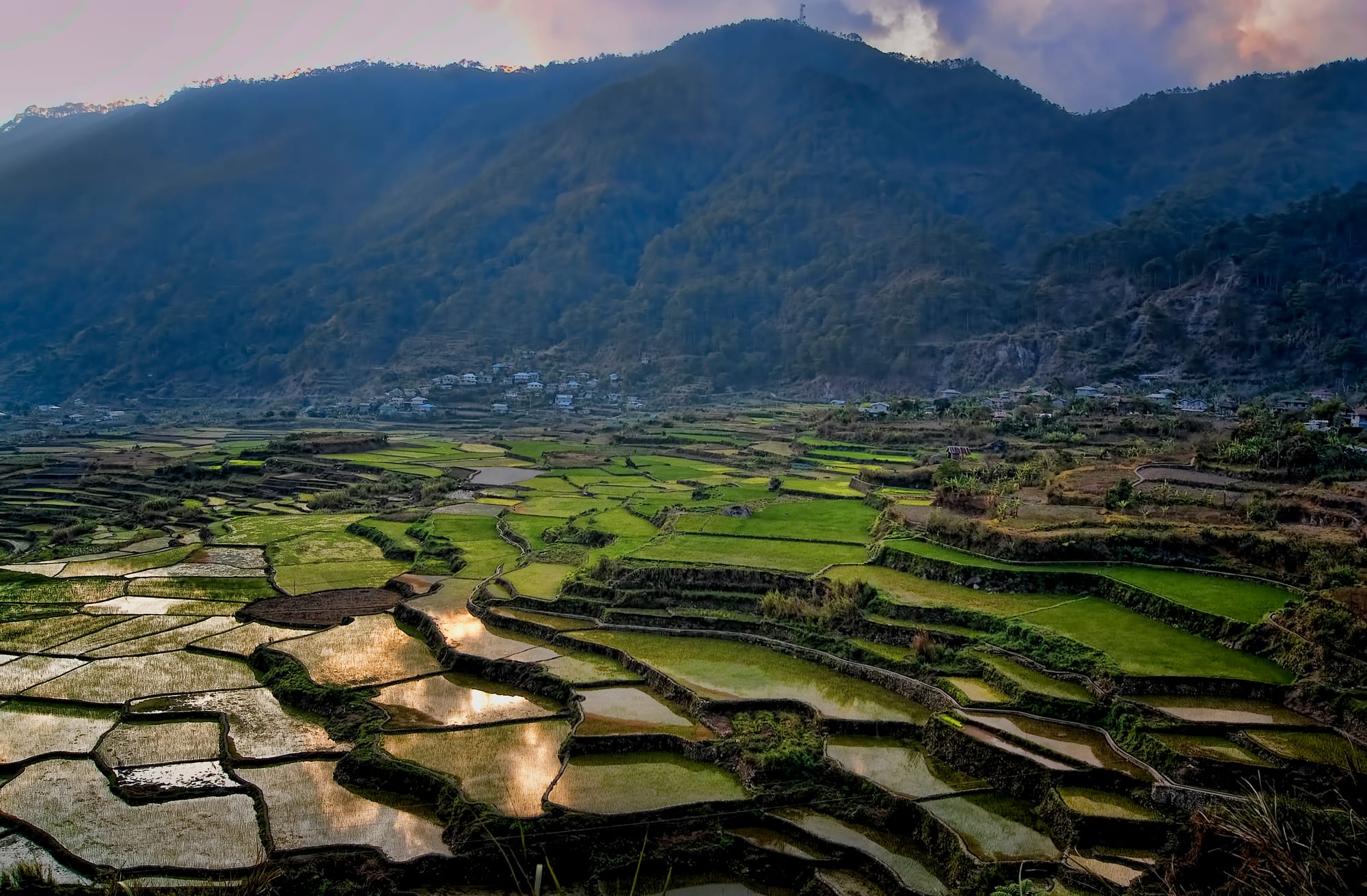
Stone-walled rice terraces, some flooded and reflecting the sky, filling a valley below forested mountains and scattered houses

Northern Luzon, Philippines

Sagada

Rice terraces in the valley below Sagada, in Mountain Province. (Philip Nalangan / Wikimedia Commons · CC BY-SA 4.0)

A small mountain town in Mountain Province, in the Cordillera highlands of northern Luzon, at around 1,500 metres among pine ridges and limestone cliffs. Long an Episcopalian mission centre among the Kankanaey, it is known for burial caves and coffins hung on rock faces, for caving and waterfall walks, and for cool weather, coffee and quiet.

Neighbourhoods

  • Poblacion
    • First-time visitors
    • Cafés
    • Close to transport

    The town centre, a short grid of lodges, cafés, craft shops and the tourism office on the main road. Almost everything a visitor arranges starts here, and the churchyard, the market and the bus and van stops are all within a few minutes' walk.

    Open in Maps
  • Demang
    • Local life
    • Quiet and residential

    An old ward just south of the centre, with houses stepped down the slope and customary community grounds still used for rituals. It is residential rather than commercial, and close enough to the Poblacion to walk.

    Open in Maps
  • Ambasing
    • Caves
    • Walks

    The area south of town on the road towards the burial caves and the valley below Echo Valley. Guesthouses here are quieter than those in the centre, and the cave and cliff walks begin nearby.

    Open in Maps
  • Fidelisan and Aguid
    • Rice terraces
    • Waterfalls

    Farming barangays north of the town, reached by a rough road through pine ridges. Their stone-walled rice terraces step down the valley, and the path to the big waterfall drops steeply from the village edge.

    Open in Maps
  • Balugan
    • Viewpoints
    • Quiet and residential

    A hillside settlement east of the centre where limestone outcrops break through pine forest. It sits above the town with long views over the valley, and is a starting point for ridge walks.

    Open in Maps

Things to do

Caves and burial sites

  • Echo Valley hanging coffinslandmark

    Wooden coffins fastened to limestone cliffs above a small valley behind the town, part of a Kankanaey burial custom that some families still follow.

    Open in Maps
  • Lumiang Caveattraction

    A cave mouth stacked with old wooden coffins, and the start of the long underground traverse through the limestone to Sumaguing.

    Open in Maps
  • Sumaguing Caveattraction

    A deep limestone cave whose walls hold fossil seashells, entered on a wet descent past flowstone formations and pools and visited with a guide registered at the tourism office.

    Open in Maps

Walks and viewpoints

  • Kiltepan viewpointviewpoint

    A ridge east of the town looking over terraces and the valley, best known for the cloud that fills the valley below at dawn.

    Open in Maps
  • Bomod-ok Fallsattraction

    A tall waterfall below Fidelisan, reached by a long stepped path through rice terraces north of the town.

    Open in Maps
  • Lake Danumattraction

    A small upland lake in the pines west of the centre, a short ride or a long walk from town, known for its sunsets.

    Open in Maps

In and around the town

  • Saint Mary the Virgin Churchlandmark

    The stone Episcopal church at the centre of the town, built by the American mission that shaped Sagada from the early 20th century.

    Open in Maps
  • Calvary Hillviewpoint

    The cemetery ridge above the churchyard, where crosses stand among the pines and the All Saints' fire ritual is held.

    Open in Maps

Short trips from the town

  • Bontocneighborhood

    The provincial capital about an hour east down the mountain road, and the transport link onward to Banaue and the Ifugao terraces.

    Open in Maps
  • Banaue Rice Terraceslandmark

    The Ifugao terraces carved up whole mountainsides, a few hours east by van through Bontoc.

    Open in Maps

Seasonal events

  • All Saints' Day1 November

    Families gather at the cemetery on Calvary Hill after an evening service and light pine-wood fires on the graves, a custom particular to the town.

  • Rice-cycle ritualsseveral times a year, around the rice cycle

    Community rituals tied to planting and harvest, held at customary ward grounds, with rest days on which villagers ask visitors not to enter the fields.

  • Holy Week and ChristmasMarch or April, and late December

    The town's busiest weeks, when Filipino visitors fill the lodges, roads are slow and rooms need booking well in advance.

Eat and drink

Long-standing places and food districts in Sagada. Hours, ratings and directions come from your maps app, always current.

Sagada classics

  • Pinikpikanrestaurant

    The Cordillera chicken soup, cooked with etag, salted and smoked pork, and served in small eateries around the centre.

    Open in Maps
  • Lemon piecafe

    A tart lemon pie with meringue that has become the town's sweet speciality, sold by several bakeries and cafés in the Poblacion.

    Open in Maps
  • Sagada arabica coffeecafe

    Arabica grown on the surrounding slopes, roasted locally and served in the cafés along the main road.

    Open in Maps

Markets and food streets

  • Sagada public marketmarket

    A small market for highland vegetables, heirloom rice, coffee beans and etag, busiest on the town's market day.

    Open in Maps
  • Poblacion eateriesneighborhood

    The short main street holds most of the town's cooking, from rice-and-viand carinderias to guesthouse kitchens serving highland vegetables and yoghurt.

    Open in Maps

Experience Sagada

History

Sagada sits in Kankanaey country, high in the limestone belt of the western Cordillera, and its earliest history is written in its caves: wooden coffins stacked in rock shelters and fixed to cliffs, a burial practice that in some families continued into recent generations. Spain never brought the area under firm control, and the settlement remained a cluster of wards with their own customary law, irrigated terraces and ritual grounds.

The change came with American rule. Episcopal missionaries arrived in the first years of the 20th century, and under the priest John Staunton the mission built the Church of Saint Mary the Virgin and founded St Mary's School in 1904, introduced new trades and made Sagada one of the strongholds of the Episcopal Church in the Philippines — which is why the town's older buildings are stone-walled and mission-plain rather than Spanish colonial. A road eventually linked it to Bontoc and, over the mountains, to Baguio.

For much of the 20th century Sagada was remote and little visited. Backpackers found it from the 1970s, drawn by the caves and the cool air, and it grew slowly into one of the best-known destinations in the Cordillera; a Filipino romantic comedy filmed here, released in 2014 and given a wide cinema run the following year, brought a further surge of domestic visitors. The municipality has since had to balance that traffic against its water supply, its waste and the privacy of its burial sites, regulating guides through the tourism office and limiting access to some places.

Culture & Customs

The people of Sagada are Kankanaey, one of the Cordillera peoples who kept their own institutions through the Spanish period. Wards retain customary community grounds, and rituals tied to the rice cycle are still called at planting and harvest, with rest days on which work in the fields stops and outsiders are asked to stay clear. Elders' councils continue to settle local matters alongside the municipal government.

Christianity, in its Episcopalian form, sits alongside all this rather than replacing it. Church weddings and funerals follow older mourning customs, and on All Saints' Day families climb to the cemetery on Calvary Hill and light fires of resinous pine wood on the graves, filling the ridge with smoke. Death customs are the town's best-known feature and its most sensitive: the hanging coffins are family graves, and guides set the rules about approach and photography.

Weaving on backstrap and pedal looms produces the striped and geometric cloth used for bags, blankets and clothing, and is one of the town's older trades. Music at gatherings uses flat gongs and drums, and dancing is done in the round at weddings and feasts. The atmosphere the town is known for — quiet evenings, early nights, mist, coffee and woodsmoke — is partly enforced: local rules restrict late-night noise, and the town has long discouraged the loud bar culture found in other destinations.

Daily Life

About 11,000 people live in the municipality, spread across barangays that run from the Poblacion down steep valleys to farming hamlets such as Fidelisan, Aguid and Ambasing. Farming remains the base of the economy: irrigated rice in terraces, along with vegetables, root crops and arabica coffee grown on the slopes, much of it sold through Bontoc and Baguio.

Tourism is the other pillar, and it has reshaped the Poblacion into a street of guesthouses, cafés and craft shops where guides register and visitors sign in. The work is seasonal, peaking at Christmas, Holy Week and long weekends, when the town's small water system and narrow roads come under pressure — a recurring subject of local debate, along with waste management and proposals to cap visitor numbers. Younger residents often leave for Baguio, Manila or work abroad, and send money back.

Days start early and end early. Mornings are for fields, school and the market; afternoons cloud over and often rain; by nine in the evening the streets are quiet. Sundays are church days for much of the town. Nights are cold enough for blankets and fires year-round, a novelty in a tropical country and a large part of why Filipinos come.

Food

Cordillera cooking here is plain, smoky and built on what the slopes produce. Pinikpikan is the dish most associated with the mountains, a chicken soup traditionally prepared in a ritual manner and flavoured with etag — pork salted and smoked for months, whose strong taste also seasons vegetable dishes and soups. Heirloom highland rice, often red or purple-grained, is grown in the valley terraces and sold by the sack in the market.

Vegetables dominate the everyday table: beans, squash, chayote, cabbage and sweet potato, cooked simply and eaten with rice. Wild berries and fruit appear seasonally, and the local arabica, grown on surrounding farms and roasted in town, is served in almost every café — Sagada coffee is one of the region's better-known products. Tapuy, rice wine, is drunk at celebrations and rituals rather than casually.

The town has also acquired a set of visitor foods that locals now make as well as anyone: yoghurt with fruit and honey, made in guesthouse kitchens, and a sharp lemon meringue pie that has become the thing people carry home. Bakeries in the Poblacion sell it alongside the pies and breads of ordinary Philippine bakery culture, and small eateries serve rice meals of grilled pork, vegetables and broth from late morning until early evening.

Planning tools

Budget

Sagada is inexpensive by Philippine standards. Rooms in guesthouses and inns are cheap, meals in local eateries cheaper still, and the main additional costs are the compulsory guide fees arranged through the tourism office, the environmental fee charged on arrival, and hired vehicles or tricycles to trailheads outside the centre. Prices and availability tighten at Christmas, Holy Week and long weekends.

Daily Budget Midrange
USD 55–110 (comfortable inn, restaurant meals, caving and waterfall guides, a hired van or jeepney)
Daily Budget Shoestring
USD 25–40 (guesthouse room, carinderia meals, shared tricycles, one guided walk)

Bring enough cash: cash machines in the town are few and unreliable, and most lodges, guides and eateries deal in cash only.

Best Time to Visit

December to May is the drier half of the year and the easiest time for caves, waterfalls and mountain roads. December to February brings the coldest nights and the clearest mornings for cloud views over the valley. The southwest monsoon from June to September is wet, with landslides possible on the approach roads, and the typhoon months run roughly from June to November.

Suggested Number of Days

Two or three days suit the town itself, since walks and caves take half a day each and guides need arranging in advance. Four or five allow the outlying barangays and a continuation deeper into the Cordillera. Long travel times in and out add a day at each end.

First Visit
2–3 days
With Surroundings
4–5 days

Transportation

The town is small enough to cross on foot. Tricycles and jeepneys run to the outlying barangays and trailheads, and jeepneys serve villages such as Fidelisan on set departures rather than frequently. Hiring a van or a tricycle for the day is the usual way to reach the viewpoints, the lake and the far terraces.

Caves and several of the walks may only be done with a registered guide booked through the municipal tourism office, which sets the rates and group sizes.

Airport & Station Connections

There is no airport or railway. Most visitors come by bus from Baguio along the Halsema Highway, a winding mountain drive of roughly five to six hours, or on overnight services from Manila that take twelve hours or more. From the east, vans and jeepneys connect through Bontoc, about an hour away, which is also the link to Banaue and the Ifugao terraces.

Walkability

The Poblacion is compact and walkable, with lodges, eateries, the church and the tourism office within a few minutes of each other. Beyond it everything is steep: paths to the coffins, the caves and the waterfalls involve long descents and climbs on uneven stone, slippery after rain, and the thin mountain air and gradients make short distances feel longer.

Safety

Crime against visitors is rare and the town is quiet at night. The real risks are physical: slippery cave passages and river crossings, steep unfenced paths near the cliffs, and landslides or closed roads on the mountain highways during heavy rain. Mobile signal and medical facilities are limited, and the nearest hospital of any size is in Bontoc.

Monitor PAGASA for storms, keep away from volcanic danger zones, take dengue precautions year-round, and do not travel to the Sulu provinces or the Zamboanga peninsula. Check current official travel advice before travelling.

Climate

A cool highland climate at about 1,500 metres, far milder than the lowlands. Days are generally in the high teens or low twenties Celsius, nights are cold by Philippine standards, and cloud and mist sit in the valleys for much of the year. Rain is heaviest under the southwest monsoon.

Summer
mild and often wet, about 15–25°C, with heavy monsoon rain from June to September
Winter
cool and mostly dry, about 12–22°C by day and close to 10°C on the coldest December to February nights

Local Customs

This is a Kankanaey town with living burial and farming customs, and the coffins, caves and cemeteries are graves rather than exhibits. Guides explain what may be approached and photographed; during rest days declared for community rituals, villagers ask that fields and certain grounds are left alone. Dress warmly and modestly, and greet elders first. Most of the town is Episcopalian, and Sunday services are well attended.

Ask before photographing people, burial sites or rituals, take litter back out of the caves and valleys, and keep noise down in the town at night, when many lodges observe a quiet hour.

Common Payment Methods

The currency is the Philippine peso. Cash is used for almost everything — guides, fees, tricycles, eateries and most lodges — and the few cash machines in town can run empty at busy weekends. Cards are accepted by only a handful of businesses, so withdraw in Baguio or Bontoc before arriving.